It looks like you're using an Ad Blocker.
Please white-list or disable AboveTopSecret.com in your ad-blocking tool.
Thank you.
Some features of ATS will be disabled while you continue to use an ad-blocker.

Hurricane Irma strengthening in the Atlantic
page: 28share:
I wasn't laughing because I think a 1-2ft surge is funny, I was laughing because the linked map is so garbage it projected a 1-2 ft surge for Miami
beach, and everything else suggests a far worse surge.
edit on 8-9-2017 by MysticPearl because: (no reason given)
originally posted by: MysticPearl
I wasn't laughing because I think a 1-2ft surge is funny, I was laughing because the linked map is so garbage it projected a 1-2 ft surge for Miami beach, and everything else suggests a far worse surge.
Oh ok.
Maybe because it was a watch zone in that? It gets upgraded as time closes in, being they are tied into how many hours in advance they can issue warnings. I'll post an updated map . You can see if that looks right
a reply to: MysticPearl
The national hurricane Center said it might be 10 ft
Do you mean this Map ?
Perhaps so then
They have a Facebook page, you should post the pic and ask them what's up
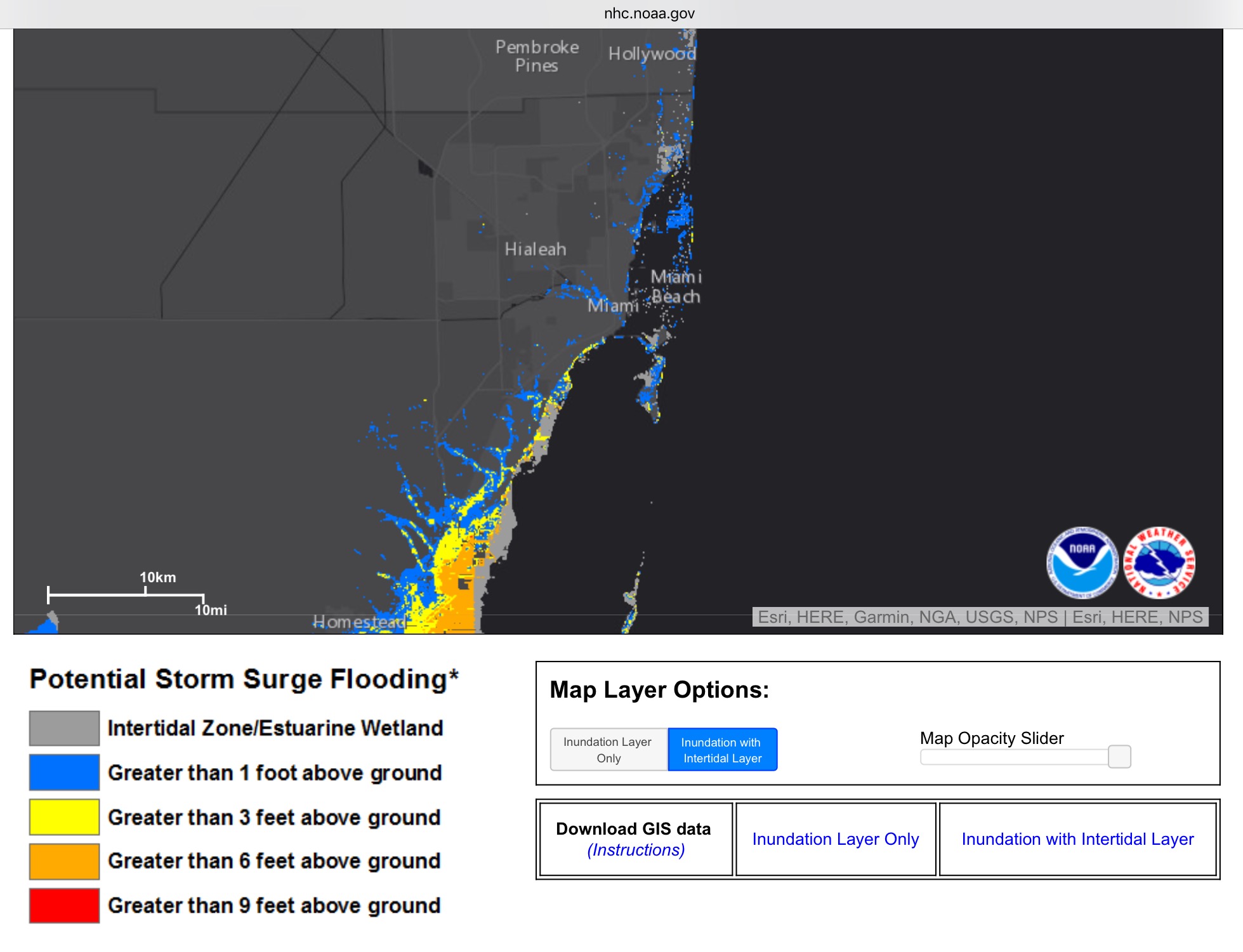
There was a click to agree disclaimer thing before viewing the map, i of course did not read
The national hurricane Center said it might be 10 ft
Do you mean this Map ?
Perhaps so then
edit on 8-9-2017 by violet because: (no reason given)
edit on 8-9-2017 by violet because: (no reason
given)
They have a Facebook page, you should post the pic and ask them what's up
edit on 8-9-2017 by violet because: (no reason given)
edit on 8-9-2017 by violet because: (no reason
given)
There was a click to agree disclaimer thing before viewing the map, i of course did not read
edit on 8-9-2017 by violet because: (no reason
given)
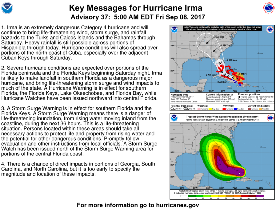
IRMA MOVING THROUGH THE SOUTHEASTERN BAHAMAS AS AN EXTREMELY DANGEROUS CATEGORY 4 HURRICANE...
Irma is forecast to remain in a favorable warm water, light shear
environment for the next 36-48 h. The intensity guidance shows a
slow weakening during this time, but Irma is expected to remain at
least a Category 4 hurricane until landfall in Florida. After
landfall, a fairly quick decay in maximum winds is expected due to
land interaction and increased shear, although Irma's large wind
field is likely to still produce hurricane-force winds over a large
area. There are two caveats to the intensity forecast. First, some
additional weakening could occur during the eyewall replacement,
followed by re-intensification as the cycle completes. Second, the
ECMWF, UKMET, and NAVGEM forecast a track over or close to the
coast of Cuba that is not currently a part of the track forecast.
If this occurs, Irma could be weaker than currently forecast along
the later parts of the track.
...................
Overall, the new forecast track is
similar to the previous forecast, with minor westward adjustments
at 36 and 48 h.
NHC
edit on 8-9-2017 by violet because: (no reason given)
edit on 8-9-2017 by violet because: (no reason
given)
originally posted by: NightSkyeB4Dawn
a reply to: Dumbass
I have seen some ugly pictures of the devastation wrecked on the islands, including St. Martin.
I still have not heard from my family over there, and no one else in the family has heard anything either. We are all texting and emailing because we know that we stand a better chance of making a connection that way, since the power is probably out across the island.
I hate Facebook but this is a time it would come in handy. But no connection there either.
No personal news here yet, but reports are dripping in through a local radio station located at St. Martin. Just saying what I heard on that. Mobile and internet mostly unavailable, landlines can receive international calls but can't call out. Extensive damages but luckily not many casualties reported. Efforts bring relief and help are slowly dripping in. There was a lot of looting but that is mostly under control now with the help of Dutch and French military. The spirit to rebuild is strong.
Rush Limbaugh will be evacuating South Florida, just days after the popular conservative radio host claimed that Hurricane Irma would not hit the United States and that scientists and the liberal media were hyping up the hurricane as proof of their global warming “lie.”
Link
lol X 10^3
I think it would be better if he sat on Miami Beach and broadcasted to demonstrate there is no reason to be alarmed.
edit on 9/8/2017 by
roadgravel because: typo
Hurricane Jose is now a Cat 4.
Katia, Irma and Jose
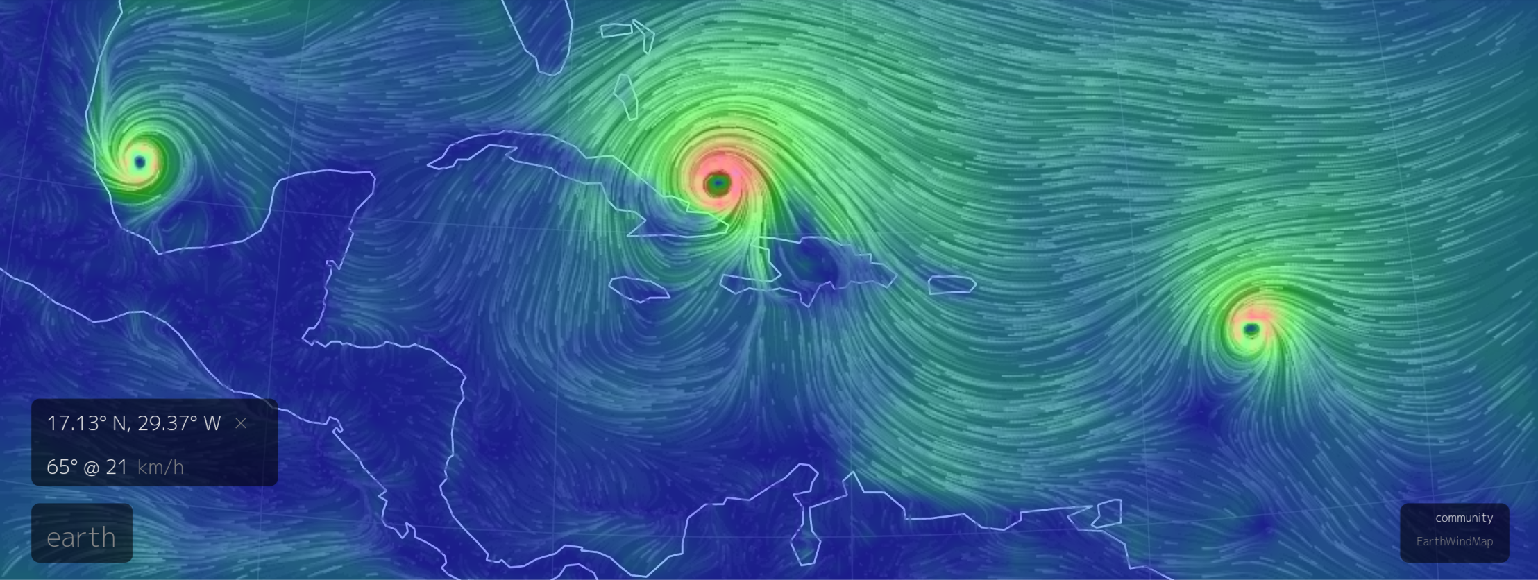
Source
Source
Jose strengthened to a Category 4 hurricane, with maximum sustained winds of 150 mph, in the central Atlantic Ocean – the third major hurricane of the 2017 season – and may threaten portions of the Leeward Islands this weekend.
Katia, Irma and Jose
Source
Source
edit on 8-9-2017
by DancedWithWolves because: (no reason given)
If you guys wanta set up your own personal map, this is pretty close to what we have with a few less whistles and bells.
www.ventusky.com...
www.ventusky.com...
edit on 8-9-2017 by flatbush71 because: (no reason given)
Okay, so how do you prepare if you can't get out of Florida?
This is your enemy as of 11AM EST, 9/8/2017. Note that it is getting stronger, not weaker.
How To Not Die (Or Suffer More Than You Have To)
(See post about 3/4 of the way down the page)
***SNIP***
Important Note:
.
This is your enemy as of 11AM EST, 9/8/2017. Note that it is getting stronger, not weaker.
How To Not Die (Or Suffer More Than You Have To)
(See post about 3/4 of the way down the page)
***SNIP***
Important Note:
15d.) Cross-Posting: You will not cross-post content from other discussion boards (unless you receive advance written permission from TAN or their agents).
.
edit on 8/9/2017 by ProphetZoroaster because: (no reason given)
edit on 8/9/2017 by ProphetZoroaster because: (no reason
given)
edit on 9/8/2017 by Blaine91555 because: Snipped cross posted content and edited in link to material.
Does anyone know approximately WHEN hurricane Irma is supposed to start the right-hand/northward turn?
originally posted by: flatbush71
If you guys wanta set up your own personal map, this is pretty close to what we have with a few less whistles and bells.
www.ventusky.com...
Interesting....
From that model it looks like Irma will not break NE but swing over into the Gulf. That being the case, the warmer gulf water could really increase the danger in the Gulf coastal states.
This truly a popcorn eating event.
As all you can do is sit and watch.
There satellite data is a little off, but hey its a free browser program.
But in general it is pretty good.
You can advance the time with realtime info.
As all you can do is sit and watch.
There satellite data is a little off, but hey its a free browser program.
But in general it is pretty good.
You can advance the time with realtime info.
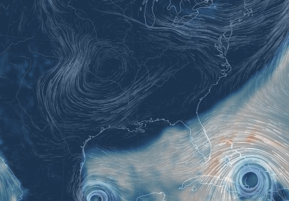
If you look at Nashville ,Tenn you'll see a circle.
That's the pressure system that counts.
That's the pressure system that counts.
edit on 8-9-2017 by flatbush71 because: (no reason given)
originally posted by: olaru12
originally posted by: flatbush71
If you guys wanta set up your own personal map, this is pretty close to what we have with a few less whistles and bells.
www.ventusky.com...
Interesting....
From that model it looks like Irma will not break NE but swing over into the Gulf. That being the case, the warmer gulf water could really increase the danger in the Gulf coastal states.
My main concern is that IRMA will NOT turn north at the time predicted. The toughest thing to predict with IRMA is when that will happen.
Larger hurricanes often "push back" against steering currents. If the turn north is delayed, there will be a lot of MAD people, a lot of HAPPY people, and an entirely new batch of SCARED people in the Florida Panhandle, Mississippi, Alabama, and Louisiana.
That's why I asked WHEN this turn is expected to occur.. what time on Saturday. Start counting the hours that it doesn't happen, and watch the dismay, awe, and denial, mount with the media, and government officials.
edit on 9/8/2017 by carewemust because: (no reason given)
Latest Updates
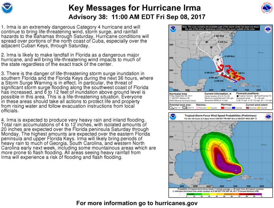
EYE OF HURRICANE IRMA MONITORED BY HURRICANE HUNTER PLANES AND CUBAN RADARS... ...HURRICANE CONDITIONS SPREADING WESTWARD OVER PORTIONS OF CUBA AND THE CENTRAL BAHAMAS.
11:00 AM EDT Fri Sep 8
Status Category 4
Location: 22.0°N 75.3°W
Moving: WNW at 14 mph
Min pressure: 927 mb
Max sustained: 150 mph
NHC
edit on 8-9-2017 by violet because: (no reason given)
a reply to: carewemust
Hurricanes have been known to go against every prediction. They have been known to do exactly as predicted and turn around for a do over.
That is why I am extremely respectful of hurricanes. I hate putting up shutters and taking them down, especially the ones on the top, but I would much rather grumble about the darn shutters than think about what could happen without them.
I keep hearing evacuation orders being put in place for new areas. Then I hear that it is taking two hours just to go 70 miles. In a situation where gas is scarce, I don't know if evacuating is a good option, unless you have no other choice.
I am praying for all of us. There is not much more we can do.
The hurricane should continue on this track for the next 24
hours.
After that time, Irma will reach the southwestern edge of
the subtropical high and begin to turn north-northwestward and
northward.
This turn will occur, but the precise moment is still
uncertain, and that is why NHC emphasizes that nobody should focus
on the exact track of the center.
www.nhc.noaa.gov...
Well I'm about as ready as I'm going to get. Few more things to move over to the main house. I don't think we will really have a good idea about what
it's going to do until a little later tomorrow. Being in Okeechobee I'll be watching just as others very closely.
There is just so much information to absorb of it going this way or that way. I'd much rather be on the west side of it as oppose to the east side. Sigh, time will tell.
Night Sky? I'd love to trade numbers with you just so we can know if we are ok or not. I know we aren't besties or anything, but we are ATSers! No harm no foul if you'd rather not.
new topics
-
A Warning to America: 25 Ways the US is Being Destroyed
New World Order: 1 hours ago -
America's Greatest Ally
General Chit Chat: 2 hours ago -
President BIDEN's FBI Raided Donald Trump's Florida Home for OBAMA-NORTH KOREA Documents.
Political Conspiracies: 7 hours ago -
Maestro Benedetto
Literature: 8 hours ago -
Is AI Better Than the Hollywood Elite?
Movies: 8 hours ago
top topics
-
President BIDEN's FBI Raided Donald Trump's Florida Home for OBAMA-NORTH KOREA Documents.
Political Conspiracies: 7 hours ago, 27 flags -
Weinstein's conviction overturned
Mainstream News: 16 hours ago, 8 flags -
Gaza Terrorists Attack US Humanitarian Pier During Construction
Middle East Issues: 13 hours ago, 8 flags -
Massachusetts Drag Queen Leads Young Kids in Free Palestine Chant
Social Issues and Civil Unrest: 15 hours ago, 7 flags -
Las Vegas UFO Spotting Teen Traumatized by Demon Creature in Backyard
Aliens and UFOs: 12 hours ago, 6 flags -
Meadows, Giuliani Among 11 Indicted in Arizona in Latest 2020 Election Subversion Case
Mainstream News: 15 hours ago, 5 flags -
2024 Pigeon Forge Rod Run - On the Strip (Video made for you)
Automotive Discussion: 13 hours ago, 4 flags -
Is AI Better Than the Hollywood Elite?
Movies: 8 hours ago, 3 flags -
A Warning to America: 25 Ways the US is Being Destroyed
New World Order: 1 hours ago, 3 flags -
Maestro Benedetto
Literature: 8 hours ago, 1 flags
active topics
-
Russia Ukraine Update Thread - part 3
World War Three • 5732 • : F2d5thCavv2 -
The Acronym Game .. Pt.3
General Chit Chat • 7751 • : F2d5thCavv2 -
Salvador Dali's Moustaches
People • 28 • : zosimov -
Is AI Better Than the Hollywood Elite?
Movies • 17 • : ThePsycheaux -
The best Rice dish i've ever tasted... Kimchi Rice
Food and Cooking • 26 • : lamhaocc -
A Warning to America: 25 Ways the US is Being Destroyed
New World Order • 1 • : 727Sky -
Massachusetts Drag Queen Leads Young Kids in Free Palestine Chant
Social Issues and Civil Unrest • 15 • : tarantulabite1 -
America's Greatest Ally
General Chit Chat • 1 • : BingoMcGoof -
How ageing is" immune deficiency"
Medical Issues & Conspiracies • 35 • : annonentity -
HORRIBLE !! Russian Soldier Drinking Own Urine To Survive In Battle
World War Three • 49 • : Freeborn