It looks like you're using an Ad Blocker.
Please white-list or disable AboveTopSecret.com in your ad-blocking tool.
Thank you.
Some features of ATS will be disabled while you continue to use an ad-blocker.

Hurricane Irma strengthening in the Atlantic
page: 26share:
originally posted by: Willtell
Here's my point
I’m talking about the odds of a hurricane in the wide open space just happening to fall on these major US cities wrecking havoc.
Then I guess most of the time Hurricanes just end up over unpopullated empty land, right?
Considering the same places generally get hit that would indicate their is probably a scientific reason why that happens.
originally posted by: carewemust
originally posted by: violet
originally posted by: Willtell
What amazes me is what are the chances or odds of these hurricanes so exactly hitting these major cities.
Is that a little fishy?
Nothing fishy about it. Its peak hurricane season. They originate off the coast of Africa this time of year and form into tropical depressions in the Atlantic, then a tropical storm and once entering warmer water get fuelled and become hurricanes
Really it's to be expected and it has been forewarned storms around the planet will intensify
One day, mankind will be technologically advanced enough to disrupt the tropical depressions enough to prevent them from becoming stronger.
Yeah, can’t they nuke these storms while their in the middle of the ocean. I’m being facetious, of course, I think.
I mean would that be like using a jackhammer to kill a roach?
Maybe we aught to unleash some of Kim’s nukes at em.
edit on 7-9-2017 by Willtell because: (no reason given)

originally posted by: ProphetZoroaster
The fact that the eye wall replacement cycle is progressing does not sound good at all.
What are the ramifications of that?
Latest update:
www.nhc.noaa.gov...
...HURRICANE AND STORM SURGE WARNINGS ISSUED FOR SOUTH FLORIDA AND THE FLORIDA KEYS...
11:00 PM EDT Thu Sep 7
Status Category 5
Location: 21.3°N 72.4°W
Moving: WNW at 16 mph
Min pressure: 920 mb
Max sustained: 165 mph
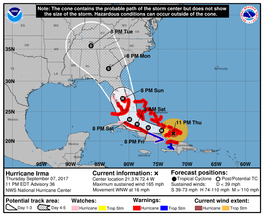
Keep in mind tornadoes will be in the mix
Irma is a potentially catastrophic category 5 hurricane and will
continue to bring life-threatening wind, storm surge, and rainfall
hazards to the Turks and Caicos Islands and the Bahamas through
Saturday. Heavy rainfall is still possible across portions of
Hispaniola through Friday. Hurricane conditions will also
spread over portions of the north coast of Cuba, especially over
the adjacent Cuban Keys through Saturday.
2. Severe hurricane conditions are expected over portions of the
Florida peninsula and the Florida Keys beginning late Saturday.
Irma could make landfall in southern Florida as a dangerous major
hurricane, and bring life-threatening storm surge and wind impacts
to much of the state. A Hurricane Warning is in effect for southern
Florida, the Florida Keys, Lake Okeechobee, and Florida Bay, while
Hurricane Watches have been issued northward into central Florida.
3. A Storm Surge Warning is in effect for southern Florida and the
Florida Keys. A Storm Surge Warning means there is a danger of
life-threatening inundation, from rising water moving inland from
the coastline, during the next 36 hours in the indicated locations.
For a depiction of areas at risk, please see the National Weather
Service Storm Surge Watch/Warning Graphic, available at
hurricanes.gov. This is a life-threatening situation. Persons
located within these areas should take all necessary actions to
protect life and property from rising water and the potential for
other dangerous conditions. Promptly follow evacuation and other
instructions from local officials. A Storm Surge Watch has been
issued north of the Storm Surge Warning for portions of the central
Florida coast.
4. There is a chance of direct impacts in portions of Georgia,
South Carolina, and North Carolina, but it is too early to specify
the magnitude and location of these impacts.
www.nhc.noaa.gov...
...HURRICANE AND STORM SURGE WARNINGS ISSUED FOR SOUTH FLORIDA AND THE FLORIDA KEYS...
11:00 PM EDT Thu Sep 7
Status Category 5
Location: 21.3°N 72.4°W
Moving: WNW at 16 mph
Min pressure: 920 mb
Max sustained: 165 mph
Keep in mind tornadoes will be in the mix
Irma is a potentially catastrophic category 5 hurricane and will
continue to bring life-threatening wind, storm surge, and rainfall
hazards to the Turks and Caicos Islands and the Bahamas through
Saturday. Heavy rainfall is still possible across portions of
Hispaniola through Friday. Hurricane conditions will also
spread over portions of the north coast of Cuba, especially over
the adjacent Cuban Keys through Saturday.
2. Severe hurricane conditions are expected over portions of the
Florida peninsula and the Florida Keys beginning late Saturday.
Irma could make landfall in southern Florida as a dangerous major
hurricane, and bring life-threatening storm surge and wind impacts
to much of the state. A Hurricane Warning is in effect for southern
Florida, the Florida Keys, Lake Okeechobee, and Florida Bay, while
Hurricane Watches have been issued northward into central Florida.
3. A Storm Surge Warning is in effect for southern Florida and the
Florida Keys. A Storm Surge Warning means there is a danger of
life-threatening inundation, from rising water moving inland from
the coastline, during the next 36 hours in the indicated locations.
For a depiction of areas at risk, please see the National Weather
Service Storm Surge Watch/Warning Graphic, available at
hurricanes.gov. This is a life-threatening situation. Persons
located within these areas should take all necessary actions to
protect life and property from rising water and the potential for
other dangerous conditions. Promptly follow evacuation and other
instructions from local officials. A Storm Surge Watch has been
issued north of the Storm Surge Warning for portions of the central
Florida coast.
4. There is a chance of direct impacts in portions of Georgia,
South Carolina, and North Carolina, but it is too early to specify
the magnitude and location of these impacts.
edit on Thu Sep 7 2017 by DontTreadOnMe because: SOURCE ADDED
originally posted by: Willtell
originally posted by: carewemust
originally posted by: violet
originally posted by: Willtell
What amazes me is what are the chances or odds of these hurricanes so exactly hitting these major cities.
Is that a little fishy?
Nothing fishy about it. Its peak hurricane season. They originate off the coast of Africa this time of year and form into tropical depressions in the Atlantic, then a tropical storm and once entering warmer water get fuelled and become hurricanes
Really it's to be expected and it has been forewarned storms around the planet will intensify
One day, mankind will be technologically advanced enough to disrupt the tropical depressions enough to prevent them from becoming stronger.
Yeah, can’t they nuke these storms while their in the middle of the ocean. I’m being facetious, of course, I think.
I mean would that be like using a jackhammer to kill a roach?
Maybe we aught to unleash some of Kim’s nukes at em.
If there was a bomb that could make the clouds cool, a tropical depression would not become a hurricane. Some kind of bomb that produces extreme cold over the tropical depression would do it.


a reply to: sligtlyskeptical
I'm sure you are correct and that everyone will find enough resources and fuel to evacuate in plenty of time. Ironically though, Google shows more need than help for people who don't have a thousand or more liquid, right now. That must be a glitch. Thanks though... how did that not occur to me? Google...wow. We don't need no ready.gov. But it would be nice if that website they keep naming had a link, or three. Thanks for the assist.
Peace
WATCHES AND WARNINGS
NHC
HURRICANE IRMA FORECAST/ADVISORY NUMBER 36
NWS NATIONAL HURRICANE CENTER MIAMI FL AL112017
0300 UTC FRI SEP 08 2017
CHANGES IN WATCHES AND WARNINGS WITH THIS ADVISORY...
A STORM SURGE WARNING HAS BEEN ISSUED FROM JUPITER INLET SOUTHWARD
AROUND THE FLORIDA PENINSULA TO BONITA BEACH... AS WELL AS FOR THE
FLORIDA KEYS.
A HURRICANE WARNING HAS BEEN ISSUED FROM JUPITER INLET SOUTHWARD
AROUND THE FLORIDA PENINSULA TO BONITA BEACH... AS WELL AS FOR THE
FLORIDA KEYS... LAKE OKEECHOBEE... AND FLORIDA BAY.
A STORM SURGE WATCH HAS BEEN ISSUED FOR THE EAST COAST OF FLORIDA
NORTH OF JUPITER INLET TO SEBASTIAN INLET AND FOR THE WEST COAST OF
FLORIDA NORTH OF BONITA BEACH TO VENICE.
A HURRICANE WATCH HAS BEEN ISSUED FOR THE EAST COAST OF FLORIDA
NORTH OF JUPITER INLET TO SEBASTIAN INLET AND FOR THE WEST COAST OF
FLORIDA NORTH OF BONITA BEACH TO ANNA MARIA ISLAND.
THE GOVERNMENT OF THE DOMINICAN REPUBLIC HAS DISCONTINUED THE
HURRICANE WARNING FOR THE NORTH COAST OF THE DOMINICAN REPUBLIC.
SUMMARY OF WATCHES AND WARNINGS IN EFFECT...
A STORM SURGE WARNING IS IN EFFECT FOR...
* JUPITER INLET SOUTHWARD AROUND THE FLORIDA PENINSULA TO BONITA
BEACH
* FLORIDA KEYS
A STORM SURGE WATCH IS IN EFFECT FOR...
* NORTH OF JUPITER INLET TO SEBASTIAN INLET
* NORTH OF BONITA BEACH TO VENICE
A HURRICANE WARNING IS IN EFFECT FOR...
* JUPITER INLET SOUTHWARD AROUND THE FLORIDA PENINSULA TO BONITA
BEACH
* FLORIDA KEYS
* LAKE OKEECHOBEE
* FLORIDA BAY
* HAITI FROM THE NORTHERN BORDER WITH THE DOMINICAN REPUBLIC TO LE
MOLE ST. NICHOLAS
* SOUTHEASTERN BAHAMAS AND THE TURKS AND CAICOS ISLANDS
* CUBAN PROVINCES OF CAMAGUEY... CIEGO DE AVILA... SANCTI
SPIRITUS... AND
VILLA CLARA
* CENTRAL BAHAMAS
* NORTHWESTERN BAHAMAS
A HURRICANE WATCH IS IN EFFECT FOR...
* NORTH OF JUPITER INLET TO SEBASTIAN INLET
* NORTH OF BONITA BEACH TO ANNA MARIA ISLAND
* CUBAN PROVINCES OF GUANTANAMO... HOLGUIN... LAS TUNAS AND
MATANZAS.
A TROPICAL STORM WARNING IS IN EFFECT FOR...
* HAITI FROM SOUTH OF LE MOLE ST. NICHOLAS TO PORT-AU-PRINCE
* CUBAN PROVINCES OF GUANTANAMO... HOLGUIN... AND LAS TUNAS
edit on 7-9-2017 by violet because: (no reason given)
a reply to: violet
Thank-you. That 11:00pm update shows a path that's far more realistic than what's been predicted up until now. A more gradual curve to the north is more believable, than the hard right turn just before Havana, Cuba. Huge/powerful storms don't turn on a dime like that, any more than an aircraft carrier could.
But the 11:00pm update you posted is very believable. In fact, the turn north could be even more gradual...with Irma going up Florida's west coast. I'll have to check the accuweather discussion forum and see what the meteorologists are saying.
a reply to: ProphetZoroaster
Eyewall replacements are apparently something hurricanes DO.
www.wunderground.com...
I know it's wiki....but at least it's not too over my head
en.wikipedia.org...
Eyewall replacements are apparently something hurricanes DO.
Hurricane hunter observations on Thursday evening showed lower winds in Irma than earlier in the day, and found a distinct double wind maximum, caused by concentric eyewalls. By my count, this may be Irma’s 7th eyewall replacement cycle, and appears to be the first one that has notably degraded the hurricane’s maximum winds. The Air Force hurricane hunter plane in the storm Thursday night found top surface winds near 165 mph on their first pass through the eye near 7:35 pm EDT, but only 140 mph on their second pass through near 9 pm EDT. The pressure stayed nearly constant in the two passes, at 920 and 921 mb, respectively.
www.wunderground.com...
I know it's wiki....but at least it's not too over my head
en.wikipedia.org...
a reply to: DontTreadOnMe
Looks like Irma is reducing herself to a Category-4 storm, as predicted. Would be nice if the land interactions took her down another notch before the turn north occurs.
Looks like Irma is reducing herself to a Category-4 storm, as predicted. Would be nice if the land interactions took her down another notch before the turn north occurs.
a reply to: carewemust
Please keep in mind there's still no idea on where it makes landfall. It can still shift left or right.
This thing is so wide it's affecting a widespread area. Hardly matters at this point ( the track I mean)
The storm surge is very dangerous and people can die from drowning. 5-10 foot rise in water near the coast with damaging waves pushing inland
It will be a cat 4 or 5 once it makes its way up the peninsula
Where the Center comes ashore you're looking at 10 hours of hurricane force winds
originally posted by: Willtell
a reply to: carewemust
Oh really, in the end maybe the nukes will save us
Irony
Not the current nukes. They create HEAT. What's needed is a bomb that produces COLD. It explodes ABOVE the tropical depression. That cold would sink down into the depression and disrupt it badly.
a reply to: violet
Shifting right would be better for Florida, since most intense destruction from wind and storm surge occurs on the Northeast/East side of Hurricanes in the northern hemisphere.
p.s. The odds of a shift right/east for Irma are looking less likely with each computer projection, however.
Shifting right would be better for Florida, since most intense destruction from wind and storm surge occurs on the Northeast/East side of Hurricanes in the northern hemisphere.
p.s. The odds of a shift right/east for Irma are looking less likely with each computer projection, however.
edit on 9/7/2017 by carewemust
because: (no reason given)
new topics
-
Where should Trump hold his next rally
2024 Elections: 1 hours ago -
Shocking Number of Voters are Open to Committing Election Fraud
US Political Madness: 2 hours ago -
Gov Kristi Noem Shot and Killed "Less Than Worthless Dog" and a 'Smelly Goat
2024 Elections: 3 hours ago -
Falkville Robot-Man
Aliens and UFOs: 3 hours ago -
James O’Keefe: I have evidence that exposes the CIA, and it’s on camera.
Whistle Blowers and Leaked Documents: 4 hours ago -
Australian PM says the quiet part out loud - "free speech is a threat to democratic dicourse"...?!
New World Order: 4 hours ago -
Ireland VS Globalists
Social Issues and Civil Unrest: 5 hours ago -
Biden "Happy To Debate Trump"
2024 Elections: 5 hours ago -
RAAF airbase in Roswell, New Mexico is on fire
Aliens and UFOs: 6 hours ago -
What is the white pill?
Philosophy and Metaphysics: 7 hours ago
top topics
-
A Warning to America: 25 Ways the US is Being Destroyed
New World Order: 15 hours ago, 21 flags -
Blast from the past: ATS Review Podcast, 2006: With All Three Amigos
Member PODcasts: 8 hours ago, 11 flags -
James O’Keefe: I have evidence that exposes the CIA, and it’s on camera.
Whistle Blowers and Leaked Documents: 4 hours ago, 10 flags -
Biden "Happy To Debate Trump"
2024 Elections: 5 hours ago, 10 flags -
Australian PM says the quiet part out loud - "free speech is a threat to democratic dicourse"...?!
New World Order: 4 hours ago, 9 flags -
Mike Pinder The Moody Blues R.I.P.
Music: 8 hours ago, 8 flags -
What is the white pill?
Philosophy and Metaphysics: 7 hours ago, 5 flags -
RAAF airbase in Roswell, New Mexico is on fire
Aliens and UFOs: 6 hours ago, 5 flags -
Ireland VS Globalists
Social Issues and Civil Unrest: 5 hours ago, 4 flags -
Putin, Russia and the Great Architects of the Universe
ATS Skunk Works: 11 hours ago, 4 flags
active topics
-
The Acronym Game .. Pt.3
General Chit Chat • 7756 • : bally001 -
RAAF airbase in Roswell, New Mexico is on fire
Aliens and UFOs • 8 • : Skinnerbot -
Putin, Russia and the Great Architects of the Universe
ATS Skunk Works • 27 • : KnowItAllKnowNothin -
Falkville Robot-Man
Aliens and UFOs • 5 • : Ophiuchus1 -
Biden "Happy To Debate Trump"
2024 Elections • 42 • : JadedGhost -
Gold and silver prices....woo hoo
History • 86 • : lilzazz -
Mood Music Part VI
Music • 3110 • : TheDiscoKing -
University of Texas Instantly Shuts Down Anti Israel Protests
Education and Media • 308 • : cherokeetroy -
Meadows, Giuliani Among 11 Indicted in Arizona in Latest 2020 Election Subversion Case
Mainstream News • 29 • : Threadbarer -
Where should Trump hold his next rally
2024 Elections • 7 • : spacedoubt