It looks like you're using an Ad Blocker.
Please white-list or disable AboveTopSecret.com in your ad-blocking tool.
Thank you.
Some features of ATS will be disabled while you continue to use an ad-blocker.

Hurricane Irma strengthening in the Atlantic
page: 23share:
Total oh # mode in ATL. Not sure my house can handle sustained winds of 40 to 50 for so long, not to mention the gusts. And that's if the eye stays
east of us.
Cheap -ass beige box in the burbs, nothing but builder grade crap.
Cheap -ass beige box in the burbs, nothing but builder grade crap.
Thread was closed, so here it is again.
I live in Northwest FL, and I feel that we might be out of the path of Irma for now... Looks like south FL is gonna get hammered, and I wish you guys luck. Might want to get out if you haven't already.
It appears that there is tons of coverage by the media on Irma, but most of them seem to be hyping the crap out of it.. and they kind of should considering its an insane storm. But I found that the other media agencies covering Irma are more about the fear mongering than they are about actual tracking and coverage forecasts.
I have found a source that has been my goto since I found it for the latest coverage. Its a news station out of Virginia doing the coverage, and they don't sit around and fear monger the crap out of this.. One of their meteorologists has kind of become a celebrity since Irma because he provides very good graphic models, and actually explains the situation in a calm and clear manner. It appears this guy is a straight shooter, has a vast array of knowledge and graphics to help explain exactly why Irma is what it is. His name is Tim Pandajis from 13News Now out of Virginia, and I figured I'd share the latest video that he has put out so you guys can get some better coverage.
Not sure if you care about the past videos, but you can go back and watch them if you need to learn anything else. I feel this guy is better than the weather channel on the coverage of Irma. Hope you guys find this source helpful.
I can not believe the people who are refusing to evacuate... one woman was gloating about her 15 month supply of baby formula..... what about fresh
water... cant make formula with out water.... when the reporter said " what if it gets bad and you cant leave, then what ? " the look on the womans
face said it all. My infant and i are #ed....
Who do you call if, for some reason, you don't have the means or a way to evacuate? Who do you contact for help getting a way out? Asking for a
friend.
650,000 Ordered to Flee Miami-Dade in County's Largest Evacuation Ever
Source
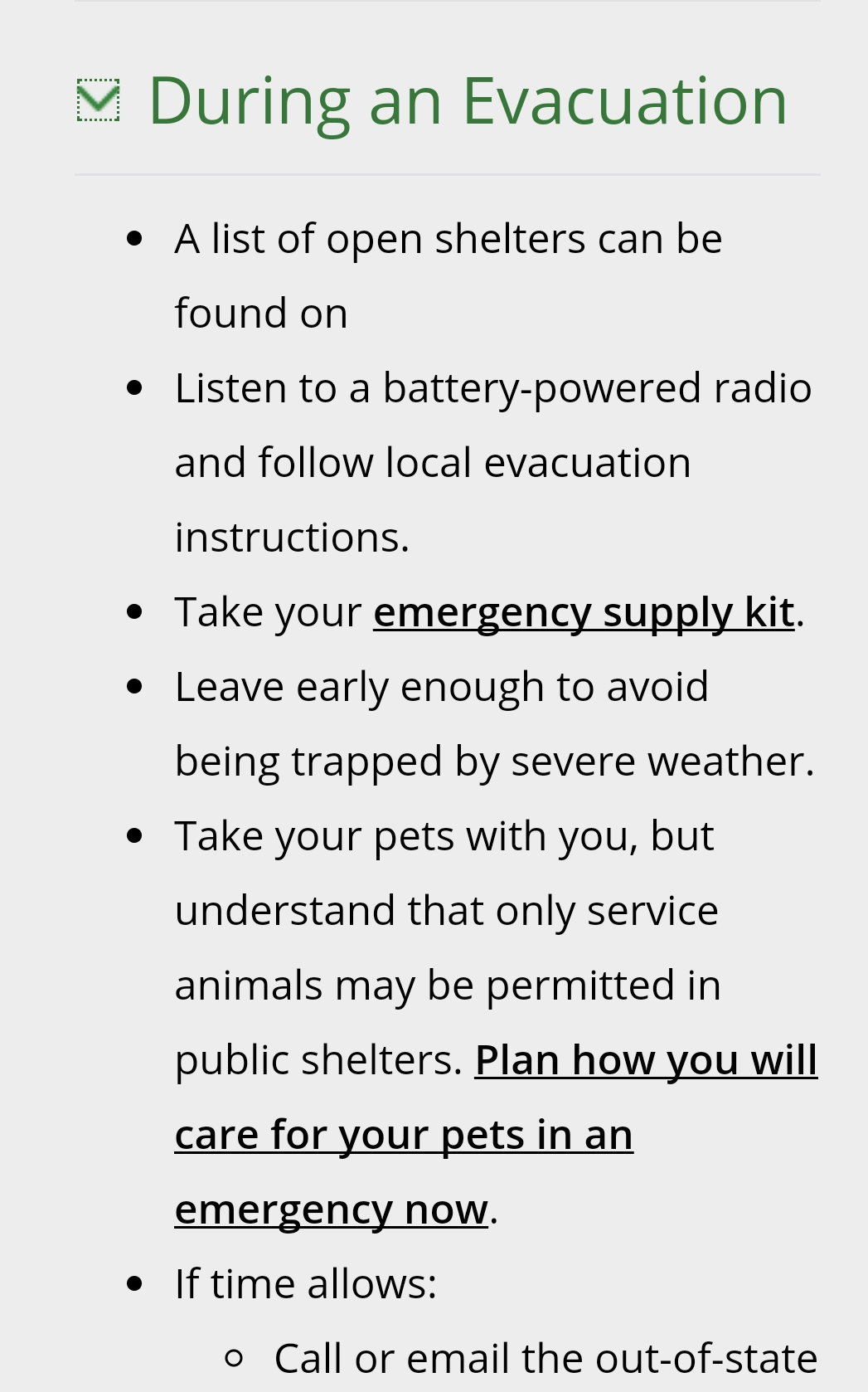
The ready.gov site checklist for During Evacuations has a "blank" on where to look for shelters or help.
Gas shortages are further complicating evacuations.
All of Florida... could be next. That's a lot of people. Not everyone has seven dollars in their pocket every day. Irma is massive.
Hotel rooms are reportedly full throughout. Where are people going and is there help to get there? Thanks all.
650,000 Ordered to Flee Miami-Dade in County's Largest Evacuation Ever
Source
The ready.gov site checklist for During Evacuations has a "blank" on where to look for shelters or help.
Gas shortages are further complicating evacuations.
All of Florida... could be next. That's a lot of people. Not everyone has seven dollars in their pocket every day. Irma is massive.
Hotel rooms are reportedly full throughout. Where are people going and is there help to get there? Thanks all.
edit on 7-9-2017 by DancedWithWolves because: (no reason given)
a reply to: violet
People tire of the news hype for sure. I know I did living there, but always had a plan in case but might not be the best if evacuation is the safest option. At the very least there's a certain sense of community that happens which of course is positive. ............................................................... Similar here as last Dec. Or so the news hyped the typhoon remnants coming shore in the New with a 100 mph or so wind warning. Many places instead had about 50 to 60 mph that was still enough to isolate areas due to bridge and ferry closures.
People tire of the news hype for sure. I know I did living there, but always had a plan in case but might not be the best if evacuation is the safest option. At the very least there's a certain sense of community that happens which of course is positive. ............................................................... Similar here as last Dec. Or so the news hyped the typhoon remnants coming shore in the New with a 100 mph or so wind warning. Many places instead had about 50 to 60 mph that was still enough to isolate areas due to bridge and ferry closures.
edit on 7-9-2017 by dreamingawake because: (no reason given)
we just got those instructions too. However; when it does hit, it will be a lesser hurricane. I'm going to ride it out, because once you leave, they
won't let you back in.
a reply to: violet
Hi, I live near Disney, in cement block house with hurricane 'prepped' windows, so we're not planning to evacuate -
- but I am starting to get a bit more worried now that the projections show the storm coming right over Orlando...
...what I wanted to ask is if you've heard anything about the cold front (which seems to be visible in the satellite image) that was supposed to be 'steering' Irma more into the Atlantic?
a reply to: Diabolical1972
One if my friends is headed back to Fl after being out of state which is also a possible landfall location. I am worried about that as is their concern for not being able to return home. Confusing and scary times for you guys...stay safe.
One if my friends is headed back to Fl after being out of state which is also a possible landfall location. I am worried about that as is their concern for not being able to return home. Confusing and scary times for you guys...stay safe.
originally posted by: eXia7
Thread was closed, so here it is again.
I live in Northwest FL, and I feel that we might be out of the path of Irma for now... Looks like south FL is gonna get hammered, and I wish you guys luck. Might want to get out if you haven't already.
It appears that there is tons of coverage by the media on Irma, but most of them seem to be hyping the crap out of it.. and they kind of should considering its an insane storm. But I found that the other media agencies covering Irma are more about the fear mongering than they are about actual tracking and coverage forecasts.
I have found a source that has been my goto since I found it for the latest coverage. Its a news station out of Virginia doing the coverage, and they don't sit around and fear monger the crap out of this.. One of their meteorologists has kind of become a celebrity since Irma because he provides very good graphic models, and actually explains the situation in a calm and clear manner. It appears this guy is a straight shooter, has a vast array of knowledge and graphics to help explain exactly why Irma is what it is. His name is Tim Pandajis from 13News Now out of Virginia, and I figured I'd share the latest video that he has put out so you guys can get some better coverage.
Not sure if you care about the past videos, but you can go back and watch them if you need to learn anything else. I feel this guy is better than the weather channel on the coverage of Irma. Hope you guys find this source helpful.
That's the best way of explaining it - clearly and calmly. A hurricane releases more energy every second with strong winds than the shockwave of a nuclear explosion. If you said the state was going to be "nuked", everyone would flee or seek shelter. but show them pictures of a big white fluffy cloud with a hole in the center, and they'll go down to the supermarket and buy out all the beer kegs and crates to watch the show. People go down to the DIY store to get chipboard to put over the windows of their beach-house. When they come back, there isn't a beach left.
It's really hard for some to comprehend that a hurricane is the atmospheric equivalent of a black hole. All the air at the ground level rises upwards and out through the "eye" of the storm. Everything else gets torn apart by the high speed winds (180+ mph). That's practically the speed of air undergoing explosive decompression in an aircraft.
...what I wanted to ask is if you've heard anything about the cold front (which seems to be visible in the satellite image) that was supposed to be 'steering' Irma more into the Atlantic?
That's the 64 dollar question.
Everyone is waiting for that fronts effect.
It will determine how far east Irma will turn.
edit on 7-9-2017 by flatbush71 because: (no reason given)
a reply to: dreamingawake
I can certainly understand that, then people become complacent.
I'd get sick of boarding up my house repeatedly if it ended up being for nothing. Especially having to leave. I'd also not enjoy being in a shelter being told what to do. You miss your own bed too much, so I can see wanting to stay in your own home. Also there's looting to worry about if you leave it. Lots of things to consider.
originally posted by: flatbush71
...what I wanted to ask is if you've heard anything about the cold front (which seems to be visible in the satellite image) that was supposed to be 'steering' Irma more into the Atlantic?
That's the 64 dollar question.
Everyone is waiting for that fronts effect.
It will determine how far east Irma will turn.
I think it's a High pressure ridge steering it now. Not sure though. Then there's the jet stream giving it a nudge.
It's not done Cuba yet as far as I know so that will be another factor coming into play.
Latest updates... not all are in yet
www.nhc.noaa.gov...
"IRMA PUMMELING THE TURKS AND CAICOS ISLANDS"
The wind is not going down much
8:00 PM EDT Thu Sep 7
Status Category 5
Location: 21.1°N 71.8°W
Moving: WNW at 16 mph
Min pressure: 919 mb
Max sustained: 175 mph
WATCHES AND WARNINGS IN EFFECT:
A Storm Surge Watch is in effect for...
* Jupiter Inlet southward around the Florida peninsula to Bonita
Beach
* Florida Keys
A Hurricane Warning is in effect for...
* Dominican Republic from Cabo Frances Viejo to the northern border
with Haiti
* Haiti from the northern border with the Dominican Republic to Le
Mole St. Nicholas
* Southeastern Bahamas and the Turks and Caicos Islands
* Cuban provinces of Camaguey, Ciego de Avila, Sancti Spiritus, and
Villa Clara
* Central Bahamas
* Northwestern Bahamas
A Hurricane Watch is in effect for...
* Jupiter Inlet southward around the Florida peninsula to Bonita
Beach
* Florida Keys
* Lake Okeechobee
* Florida Bay
* Cuban provinces of Guantanamo, Holguin, Las Tunas and Matanzas.
A Tropical Storm Warning is in effect for...
* Haiti from south of Le Mole St. Nicholas to Port-Au-Prince
* Cuban provinces of Guantanamo, Holguin, and Las Tunas
edit on 7-9-2017 by violet because: (no reason given)
edit on 7-9-2017
by violet because: (no reason given)
edit on 7-9-2017 by violet because: (no reason given)
edit on Thu Sep 7 2017 by
DontTreadOnMe because: SOURCE ADDED
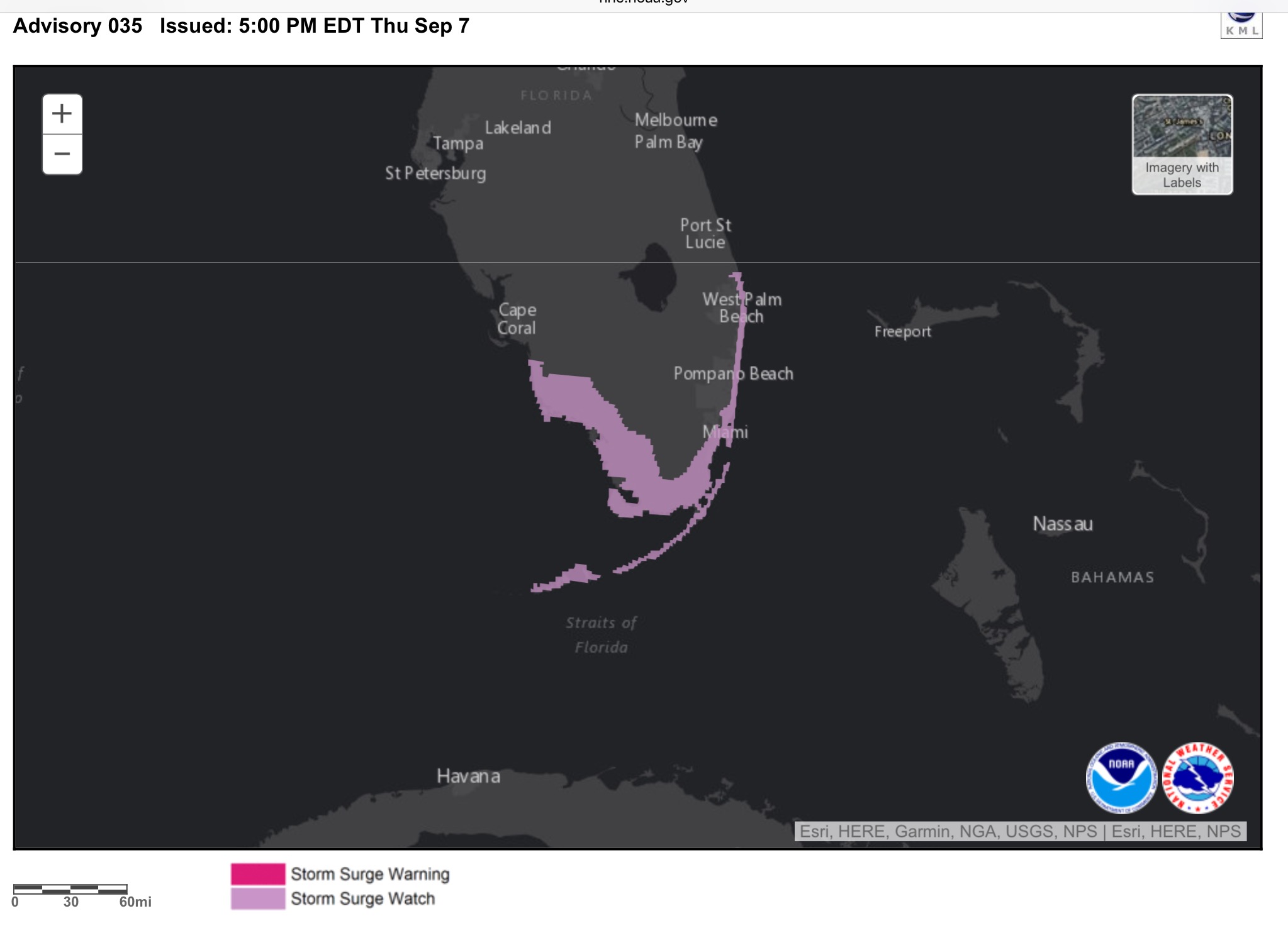
STORM SURGE WATCHES/ WARNINGS
** As it gets closer this information may change **
This is what MOAA has determined to be a "life threatening storm surge"
View interactive map here
** As it gets closer this information may change **
This is what MOAA has determined to be a "life threatening storm surge"
View interactive map here
edit on 7-9-2017 by violet because: (no reason given)
edit on 7-9-2017 by violet because: (no reason
given)
edit on 7-9-2017 by violet because: (no reason given)
edit on 7-9-2017 by violet because: (no reason
given)
Here's the model error scale.
We are give or take 60Hrs. +/- out.
Note high probability rating at 48 hours.
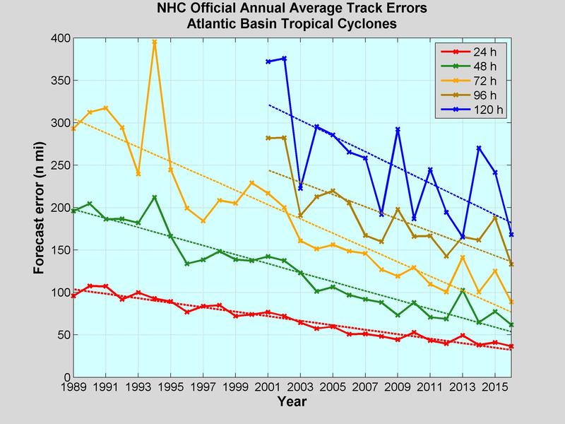
Buck
We are give or take 60Hrs. +/- out.
Note high probability rating at 48 hours.
Buck
originally posted by: lostgirl
a reply to: violet
Hi, I live near Disney, in cement block house with hurricane 'prepped' windows, so we're not planning to evacuate -
- but I am starting to get a bit more worried now that the projections show the storm coming right over Orlando...
...what I wanted to ask is if you've heard anything about the cold front (which seems to be visible in the satellite image) that was supposed to be 'steering' Irma more into the Atlantic?
I'm sorry I can't answer your question.
I think you are better prepped than others being in a concrete house though.
Stay safe and our prayers and thought are with all of you
originally posted by: violet
STORM SURGE WATCHES/ WARNINGS
** As it gets closer this information may change **
View interactive map here
With the advancements in prediction sciences, would it make sense to extend the timeline restrictions for issuing watches and warnings? It seems like adding more preparation time on the front end, would make sense, especially when most models are close to one another.
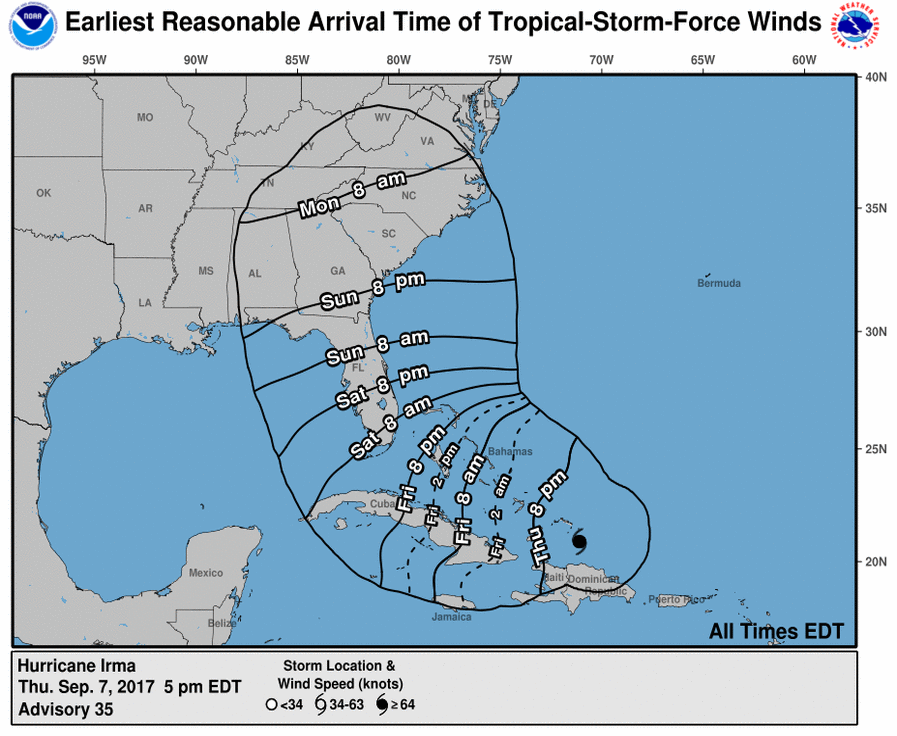
Because outside preparedness activities become difficult once winds reach tropical storm force, watches are issued 48 hours in advance of the anticipated onset of tropical-storm-force winds.
Action: During a watch, prepare your home and review your plan for evacuation in case a Hurricane or Tropical Storm Warning is issued. Listen closely to instructions from local officials.
Tropical Storm Warning: An announcement that tropical-storm conditions are expected within the specified area.Hurricane Warning: An announcement that hurricane conditions are expected within the specified area.
Because outside preparedness activities become difficult once winds reach tropical storm force, warnings are issued 36 hours in advance of the anticipated onset of tropical-storm-force winds.
48 and 36 seems a bit tight when its incoming with mandatory evacuations...anticipated.
Source
new topics
-
Maestro Benedetto
Literature: 8 minutes ago -
Is AI Better Than the Hollywood Elite?
Movies: 16 minutes ago -
Las Vegas UFO Spotting Teen Traumatized by Demon Creature in Backyard
Aliens and UFOs: 3 hours ago -
2024 Pigeon Forge Rod Run - On the Strip (Video made for you)
Automotive Discussion: 4 hours ago -
Gaza Terrorists Attack US Humanitarian Pier During Construction
Middle East Issues: 4 hours ago -
The functionality of boldening and italics is clunky and no post char limit warning?
ATS Freshman's Forum: 6 hours ago -
Meadows, Giuliani Among 11 Indicted in Arizona in Latest 2020 Election Subversion Case
Mainstream News: 6 hours ago -
Massachusetts Drag Queen Leads Young Kids in Free Palestine Chant
Social Issues and Civil Unrest: 6 hours ago -
Weinstein's conviction overturned
Mainstream News: 8 hours ago -
Supreme Court Oral Arguments 4.25.2024 - Are PRESIDENTS IMMUNE From Later Being Prosecuted.
Above Politics: 9 hours ago
top topics
-
Krystalnacht on today's most elite Universities?
Social Issues and Civil Unrest: 9 hours ago, 9 flags -
Supreme Court Oral Arguments 4.25.2024 - Are PRESIDENTS IMMUNE From Later Being Prosecuted.
Above Politics: 9 hours ago, 8 flags -
Weinstein's conviction overturned
Mainstream News: 8 hours ago, 7 flags -
University of Texas Instantly Shuts Down Anti Israel Protests
Education and Media: 12 hours ago, 6 flags -
Massachusetts Drag Queen Leads Young Kids in Free Palestine Chant
Social Issues and Civil Unrest: 6 hours ago, 6 flags -
Gaza Terrorists Attack US Humanitarian Pier During Construction
Middle East Issues: 4 hours ago, 6 flags -
Meadows, Giuliani Among 11 Indicted in Arizona in Latest 2020 Election Subversion Case
Mainstream News: 6 hours ago, 5 flags -
Las Vegas UFO Spotting Teen Traumatized by Demon Creature in Backyard
Aliens and UFOs: 3 hours ago, 3 flags -
2024 Pigeon Forge Rod Run - On the Strip (Video made for you)
Automotive Discussion: 4 hours ago, 2 flags -
Any one suspicious of fever promotions events, major investor Goldman Sachs card only.
The Gray Area: 14 hours ago, 2 flags
active topics
-
University of Texas Instantly Shuts Down Anti Israel Protests
Education and Media • 210 • : DBCowboy -
Is AI Better Than the Hollywood Elite?
Movies • 1 • : 5thHead -
British TV Presenter Refuses To Use Guest's Preferred Pronouns
Education and Media • 164 • : Annee -
VP's Secret Service agent brawls with other agents at Andrews
Mainstream News • 56 • : CarlLaFong -
Maestro Benedetto
Literature • 0 • : BrotherKinsMan -
Massachusetts Drag Queen Leads Young Kids in Free Palestine Chant
Social Issues and Civil Unrest • 11 • : marg6043 -
Electrical tricks for saving money
Education and Media • 7 • : chr0naut -
Definitive 9.11 Pentagon EVIDENCE.
9/11 Conspiracies • 424 • : Zanti Misfit -
Las Vegas UFO Spotting Teen Traumatized by Demon Creature in Backyard
Aliens and UFOs • 8 • : Macenroe82 -
SHORT STORY WRITERS CONTEST -- April 2024 -- TIME -- TIME2024
Short Stories • 23 • : DontTreadOnMe