It looks like you're using an Ad Blocker.
Please white-list or disable AboveTopSecret.com in your ad-blocking tool.
Thank you.
Some features of ATS will be disabled while you continue to use an ad-blocker.

Vast and Impressive City Ruins in Antarctica!!!
page: 6share:
Originally posted by mangust69
there is also a painter 800000 to 6 minutes total 9 + years took www.youtube.com...
I'd like those 6 minutes back please.....
Originally posted by kdog1982
General coordinates are 76 degrees 45' 59.15" s and 126 degrees 26' 49.57"w. I found it using RSOE EDIS map and matched it up with google earth.It appears to be mountain tops.
Good doggy, I've been wading through three full pages to find this utmost relevant piece of information.
EDIT:
I've checked out these coordinates, but the area does not resemble the pictures in the OP in the slightest way.
What am I missing, and how hard can it be to mention the friggin' coordinates when you discover something on Google-Earth. This is madness.
edit on 13-5-2013 by H1ght3chHippie because: (no reason given)
Originally posted by H1ght3chHippie
Originally posted by kdog1982
General coordinates are 76 degrees 45' 59.15" s and 126 degrees 26' 49.57"w. I found it using RSOE EDIS map and matched it up with google earth.It appears to be mountain tops.
Good doggy, I've been wading through three full pages to find this utmost relevant piece of information.
EDIT:
I've checked out these coordinates, but the area does not resemble the pictures in the OP in the slightest way.
What am I missing, and how hard can it be to mention the friggin' coordinates when you discover something on Google-Earth. This is madness.
edit on 13-5-2013 by H1ght3chHippie because: (no reason given)
The coordinates are off. While I know it can be a chore, if you had read through the posts, you would have found my post:
Here
with the correct coordinates.
Originally posted by Wrabbit2000
Originally posted by Hijinx
reply to post by Wrabbit2000
see
You'll be disappointed to know under all that ice, is much less land than you think. Think of it more as a cluster of islands, rather than one massive land mass.
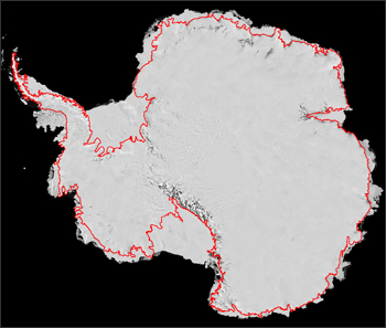
Well, with respect..I'm going to disagree with you on that one. This being one of my personal passions, I'm very familiar with what is in the public domain and science about the Continent and land mass. This is one of the most recent and accurate studies of the true land lines for the shoreline to Antarctica.
(Source:NASA / Landsat Data )
Of course, they are discovering a very complex and perhaps, actively flowing set of waterways and lakes beneath that giant sheet of ice, following the incredible discoveries around the Russian Vostok Station and Lake Vostok beneath it.
Map Characterizes Active Lakes Below Antarctic Ice (w/ Video)
The source on that last one is a sometimes dry but often times interesting site covering Physics, Earth Sciences and general Scientific topics. I've found it to be a solid source in the past.
It's a mystery Continent to be sure. Someday, I hope we have the technology to properly core down beneath the ice and start doing some exploring where the evidence indicates ice sheet movement may be little to none over the years. Seeing a landscape beneath that has been scraped like a clean sheet of stone may not hold much....but if areas exist with clear features and where the freeze came as a 'freeze in place' event to just keep piling on? Who knows... There could be some real great finds to be made. One of the final places on Earth to hold such promise. ......if only we can get to it without destroying what makes it special, of course.
edit on 13-5-2013 by Wrabbit2000 because: fixing first link
Youll be saddend to know that there has been pretty extensive mapping of topography under the ice. The current concensus is that it is mostly and archipeligo. The coast lines you posted are correct but rare is it to find interior elevation mappings which is where most f the breakup is. You also have to take into consideration that if the ice wrre to melt you have account for the increased sea levels which would totaly change the coast line
edit on 13-5-2013 by vind21 because: (no reason given)
yea i think those things are rocks covered by snow, but you might be on to something who knows, thanks for posting
This is fascinating. I don't doubt there could have been a lost civilization here before the land mass was in its current latitude.
However, other than the orthogonal lines you put in that picture, I don't see anything that looks like an ancient city.
I see rocks with a wind swept pattern of snow.
However, other than the orthogonal lines you put in that picture, I don't see anything that looks like an ancient city.
I see rocks with a wind swept pattern of snow.
Originally posted by AFewGoodWomen
Vast and Impressive City Ruins in Antarctica!!!
Thanks for sharing those rock formations. I bet those rocks are ancient.
Now...on which page can I find the IMPRESSIVE CITY your thread title promises?
reply to post by eriktheawful
Those coords I gave was just a general area from where the op had the red box in the second picture.Yours where more accurate.
Those coords I gave was just a general area from where the op had the red box in the second picture.Yours where more accurate.
reply to post by Wrabbit2000
I'm not going to challenge your knowledge of the continent wrabbit, but there are low laying areas of Antarctica that would become covered with water given the ice melted away from it's surface. There are areas where that ice is nearly a mile thick. You can't tell me you believe it wouldn't be under water if it melted.
I've never given huge devotion to antarctica but a lot of that land would at the very least turn into a giant marsh.
Originally posted by Hanslune
reply to post by Wrabbit2000
Success and being right is part of the formula - we have lots of 'no-go' threads on ATS. One can support new contributors without uncritically swallowing what they offer up.
You have to be wrong a bunch of times before you get it right. Thomas Edison didn't just wake up and say "hey, you know what?! I just realized something! Success and being right is a part of the formula! Why didn't I think of that before!???!?!?!" and then go and invent hundreds of things on the first try, every time!
Mother nature didn't just send one drop of water and say "oh, I didn't create the Grand Canyon, I guess I will give up because success and being right are a part of the formula and I failed to get it right." No, she sent a stream that, thanks to her constant efforts, became a river that sliced through the rock over the years.
I've personally known millionaires who filed for bankruptcy well over 5 times before they made it big, and any successful person will tell you- You know what? I shouldnt have to explain this to someone like you. You clearly know better and you clearly know exactly what you're doing. I don't even thing wrabbit was referring to your initial post anyway, but you can take your success and your being right and you can just... just... go sit on a tack, you!!!
Harumph! No go threads indeed...
I seen an interesting documentary on youtube about early man and it was talking about maps of the world thousands of years old of the Antarctica
before it was covered with ice and they think this was were Atlantis was! They think that a polar shift happen 12000 years ago! just watch the link at
36mins, it seem interesting!
www.youtube.com...
www.youtube.com...
Wow! It's funny that when a female posts, the replies are so...nice. I mean if a male posted this, there would be a public humiliation thread going
on here.
Anyway...as you were, metropolis err something.
Anyway...as you were, metropolis err something.
Sorry I hadn't gotten back to reply or add more after merely showing land outlines for the Continent. I know that wasn't much and speaks nothing to
the actual level of land itself.
It's also true, as noted, that the average 'over land' ice thickness is around 1 mile in thickness with areas exceeding 3 miles. If it melts, we'll all be redefining beach front property, world wide. Fortunately, there seems to be little threat of that in our lifetimes, at least.
In terms of actual land elevation. Technology and survey methods have come leaps and bounds in showing such details in ways that make the ice nearly transparent...for data readings anyway. Now, if only they could take surveys to show surface features in high enough resolution to be helpful.
Anyway, in the interests of furthering knowledge on one of my favorite mysterious places, I brought eye candy.
Behold, the Continent of Antarctica...as I'm sure you've never quite seen it before! (drum roll......)
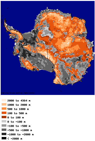
Elevations are in meters. What is grey to black is at or below sea elevation at current levels. What has color, is above it. As once can see, it's a land of real contrasts. What is deep..is VERY deep in places. Conversely, there are some flat out incredible mountain ranges, if it were possible to see them without the endless Tundra which encases them.
By comparison, here is Greenland in a similar elevation relief.
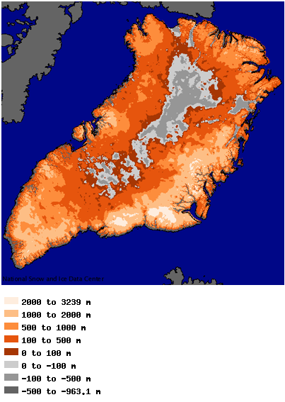
(Image Source: National Snow and Ice Data Center / NSIDC
That's also a scientific oriented data site, since we're in a forum that leans heavy toward fact vs. other forms of info. There is a great deal on other areas of it that I'm sure everyone would find interesting with similar displays and information from around the world on Snow/Ice and Ice Pack data.
It's also true, as noted, that the average 'over land' ice thickness is around 1 mile in thickness with areas exceeding 3 miles. If it melts, we'll all be redefining beach front property, world wide. Fortunately, there seems to be little threat of that in our lifetimes, at least.
In terms of actual land elevation. Technology and survey methods have come leaps and bounds in showing such details in ways that make the ice nearly transparent...for data readings anyway. Now, if only they could take surveys to show surface features in high enough resolution to be helpful.
Anyway, in the interests of furthering knowledge on one of my favorite mysterious places, I brought eye candy.
Behold, the Continent of Antarctica...as I'm sure you've never quite seen it before! (drum roll......)
Elevations are in meters. What is grey to black is at or below sea elevation at current levels. What has color, is above it. As once can see, it's a land of real contrasts. What is deep..is VERY deep in places. Conversely, there are some flat out incredible mountain ranges, if it were possible to see them without the endless Tundra which encases them.
By comparison, here is Greenland in a similar elevation relief.
(Image Source: National Snow and Ice Data Center / NSIDC
That's also a scientific oriented data site, since we're in a forum that leans heavy toward fact vs. other forms of info. There is a great deal on other areas of it that I'm sure everyone would find interesting with similar displays and information from around the world on Snow/Ice and Ice Pack data.
reply to post by Wrabbit2000
I would like to see that in a 3D rendered map; my brain doesn't always do well with the color reliefs.
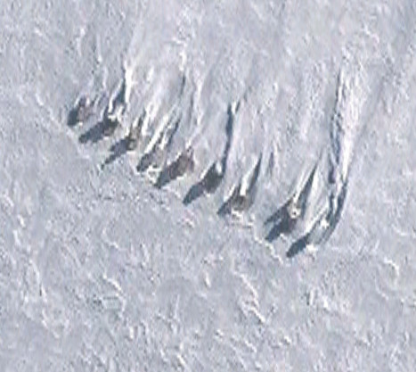
This photo by the OP:

is the one I find most interesting, and the rectangle one above it piques my curiousity (post can be found on 2nd page).
It 'feels' a bit too crafted by a being, than just windswept stuff (like the mushrooms shaped wind or water erosion picture earlier in the thread).
To the OP; just post and have fun. Don't let the grumps kill your passion and fun. If they were really interested, they'd find it, like some others have. People today think it is 'cool' to berate people, instead of being supportive. It is a shame our internet culture has basically become a bunch of trolls and very rude people, who I guarantee wouldn't take kindly to having the same grief brought to them in return. Continue to love yourself, and your life ... and in the end, these people will end up having only their self to dish out the hate to.
I would like to see that in a 3D rendered map; my brain doesn't always do well with the color reliefs.
This photo by the OP:
is the one I find most interesting, and the rectangle one above it piques my curiousity (post can be found on 2nd page).
It 'feels' a bit too crafted by a being, than just windswept stuff (like the mushrooms shaped wind or water erosion picture earlier in the thread).
To the OP; just post and have fun. Don't let the grumps kill your passion and fun. If they were really interested, they'd find it, like some others have. People today think it is 'cool' to berate people, instead of being supportive. It is a shame our internet culture has basically become a bunch of trolls and very rude people, who I guarantee wouldn't take kindly to having the same grief brought to them in return. Continue to love yourself, and your life ... and in the end, these people will end up having only their self to dish out the hate to.
reply to post by FreeThinkerIdealist
Let me get back to you on that 3-d rendering for an overland simulation. I have a feeling it's there or can be made with GIS software and the data available...but it's a few levels above my current skill level to even say that for sure. What better way to learn the software though eh?
As for the data? If someone wants the literal raw data for GIS analysis, I believe I found a pretty solid source for at least a % of the Continent. It's seasonal for even making the flights ..and remember, the entire US can fit within it's boundaries and still have a fair portion left over for good measure...not counting the flight/fuel from nearest land to get there. So, I'm impressed they have this much.
Enjoy though! I know I will be. All summer long by the look of this.
Operation Ice Bridge - Ice Bridge Data Portal
Okay, I'd like to recommend something here:
Stop using RSOE as your map to explore Antarctica.
Instead, please use Google Earth.
Here is why I (and others) should be requesting this:
1) With Google Earth, you can quickly write down the Lat and Long coordinates and share those with everyone here on ATS. It's MUCH better than drawing a box on a map. Especially when the map is stretched out like it is on RSOE and is not showing the true shape of Antarctica.
2) If you had been using Google Earth, the OP would have realized that she did in fact discover Man Made artifacts in her pictures! Google Earth will indicate these spots, and even have links to surface pictures of these areas. That way you are not "discovering" something that is already known.
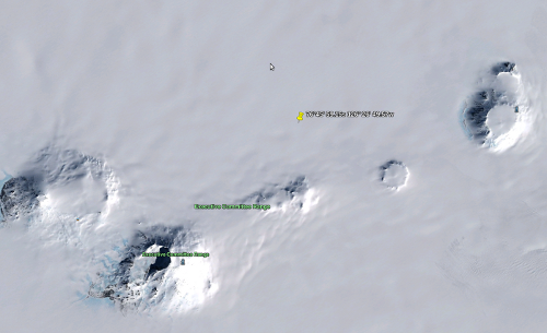
Specifically, the OP imaged several areas as strange or interesting, and in fact they are interesting, because that is where the ALE Patriot Hills Base Camp is. specifically these photos: (lat and long can be found in the link)
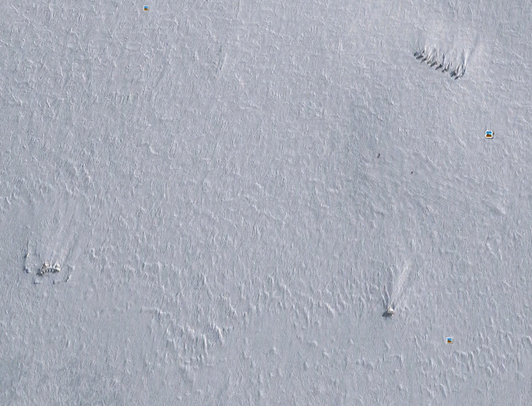
The OP noticed how these objects are evenly spaced. There's a good reason for that. They're tents that were left there:
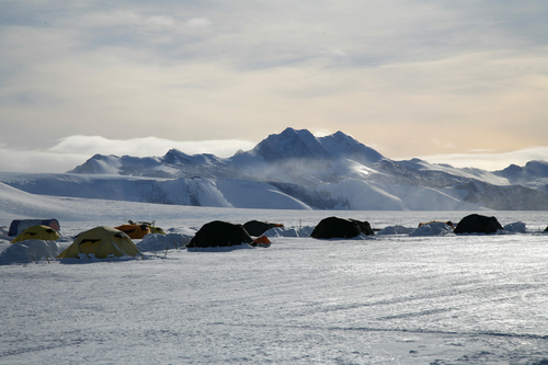
In 2010, ALE moved and left this camp there. They are now at Union Glacier. But they did leave thing behind. If you zoom in, you can see shacks too.
While I applaud the OP's effort, and others enthusiasm, remember, Antarctica is not like searching images of the moon or Mars. Humans have left their mark there quite a bit over the last 100 years You will find all sorts of artificial structures or things that do not look natural.
The key is being able to find out if what you have found is something that was put there in that last 100 years, or if it is truly a ancient find.
In order to do that, you need to look at images that may have marks (such as Google Earth) that can indicate this, or if even with Google Earth there is none, do some research on the area. The internet is filled with vast amounts of information on Antarctica including expeditions and research stations, especially those that may have been abandoned and will be partially buried by snow and ice.
Stop using RSOE as your map to explore Antarctica.
Instead, please use Google Earth.
Here is why I (and others) should be requesting this:
1) With Google Earth, you can quickly write down the Lat and Long coordinates and share those with everyone here on ATS. It's MUCH better than drawing a box on a map. Especially when the map is stretched out like it is on RSOE and is not showing the true shape of Antarctica.
2) If you had been using Google Earth, the OP would have realized that she did in fact discover Man Made artifacts in her pictures! Google Earth will indicate these spots, and even have links to surface pictures of these areas. That way you are not "discovering" something that is already known.
Specifically, the OP imaged several areas as strange or interesting, and in fact they are interesting, because that is where the ALE Patriot Hills Base Camp is. specifically these photos: (lat and long can be found in the link)
The OP noticed how these objects are evenly spaced. There's a good reason for that. They're tents that were left there:
In 2010, ALE moved and left this camp there. They are now at Union Glacier. But they did leave thing behind. If you zoom in, you can see shacks too.
While I applaud the OP's effort, and others enthusiasm, remember, Antarctica is not like searching images of the moon or Mars. Humans have left their mark there quite a bit over the last 100 years You will find all sorts of artificial structures or things that do not look natural.
The key is being able to find out if what you have found is something that was put there in that last 100 years, or if it is truly a ancient find.
In order to do that, you need to look at images that may have marks (such as Google Earth) that can indicate this, or if even with Google Earth there is none, do some research on the area. The internet is filled with vast amounts of information on Antarctica including expeditions and research stations, especially those that may have been abandoned and will be partially buried by snow and ice.
edit on 13-5-2013 by eriktheawful
because: (no reason given)
edit on 13-5-2013 by eriktheawful because: (no reason given)
So 6 pages later and we have deduced that the same ancient builders responsible for the Mars city formations (rocks) are responsible in Antarctica?
Check.
✓
Great news!
✓
Great news!
Any cities that might have been are crushed under than much ice, flattened with the rest of the continental topography.
edit on 13-5-2013 by
Syrus Magistus because: (no reason given)
new topics
-
A Warning to America: 25 Ways the US is Being Destroyed
New World Order: 1 hours ago -
America's Greatest Ally
General Chit Chat: 1 hours ago -
President BIDEN's FBI Raided Donald Trump's Florida Home for OBAMA-NORTH KOREA Documents.
Political Conspiracies: 6 hours ago -
Maestro Benedetto
Literature: 8 hours ago -
Is AI Better Than the Hollywood Elite?
Movies: 8 hours ago -
Las Vegas UFO Spotting Teen Traumatized by Demon Creature in Backyard
Aliens and UFOs: 11 hours ago
top topics
-
President BIDEN's FBI Raided Donald Trump's Florida Home for OBAMA-NORTH KOREA Documents.
Political Conspiracies: 6 hours ago, 27 flags -
Supreme Court Oral Arguments 4.25.2024 - Are PRESIDENTS IMMUNE From Later Being Prosecuted.
Above Politics: 17 hours ago, 8 flags -
Weinstein's conviction overturned
Mainstream News: 16 hours ago, 8 flags -
Gaza Terrorists Attack US Humanitarian Pier During Construction
Middle East Issues: 13 hours ago, 8 flags -
Massachusetts Drag Queen Leads Young Kids in Free Palestine Chant
Social Issues and Civil Unrest: 15 hours ago, 7 flags -
Las Vegas UFO Spotting Teen Traumatized by Demon Creature in Backyard
Aliens and UFOs: 11 hours ago, 6 flags -
Meadows, Giuliani Among 11 Indicted in Arizona in Latest 2020 Election Subversion Case
Mainstream News: 14 hours ago, 5 flags -
2024 Pigeon Forge Rod Run - On the Strip (Video made for you)
Automotive Discussion: 12 hours ago, 4 flags -
Is AI Better Than the Hollywood Elite?
Movies: 8 hours ago, 3 flags -
Maestro Benedetto
Literature: 8 hours ago, 1 flags
active topics
-
The Acronym Game .. Pt.3
General Chit Chat • 7751 • : F2d5thCavv2 -
Salvador Dali's Moustaches
People • 28 • : zosimov -
Is AI Better Than the Hollywood Elite?
Movies • 17 • : ThePsycheaux -
The best Rice dish i've ever tasted... Kimchi Rice
Food and Cooking • 26 • : lamhaocc -
A Warning to America: 25 Ways the US is Being Destroyed
New World Order • 1 • : 727Sky -
Massachusetts Drag Queen Leads Young Kids in Free Palestine Chant
Social Issues and Civil Unrest • 15 • : tarantulabite1 -
America's Greatest Ally
General Chit Chat • 1 • : BingoMcGoof -
How ageing is" immune deficiency"
Medical Issues & Conspiracies • 35 • : annonentity -
HORRIBLE !! Russian Soldier Drinking Own Urine To Survive In Battle
World War Three • 49 • : Freeborn -
Gaza Terrorists Attack US Humanitarian Pier During Construction
Middle East Issues • 30 • : Asher47