It looks like you're using an Ad Blocker.
Please white-list or disable AboveTopSecret.com in your ad-blocking tool.
Thank you.
Some features of ATS will be disabled while you continue to use an ad-blocker.

Quake Watch 2011
page: 332share:
The imsal.com is working now,but as I suppose there is some data missing ,flares for 24 October 2011,if they hide something then it's for long
term,something that they expect to happen,if is for short term then they shouldn't hide so....next 12 months probably they expect major event to come
maybe an x+maximum and beyond...!!!
Magnitude
4.7
Date-Time
Thursday, October 27, 2011 at 06:37:09 UTC
Wednesday, October 26, 2011 at 11:37:09 PM at epicenter
Time of Earthquake in other Time Zones
Location
39.605°N, 120.470°W
Depth
13.7 km (8.5 miles)
Region
NORTHERN CALIFORNIA
Distances
15 km (9 miles) SSE (153°) from Whitehawk, CA
17 km (11 miles) SSE (151°) from Valley Ranch, CA
18 km (11 miles) SSE (151°) from Clio, CA
37 km (23 miles) NW (322°) from Truckee, CA
56 km (35 miles) W (279°) from Reno, NV
145 km (90 miles) NE (36°) from Sacramento, CA
Location Uncertainty
horizontal +/- 0.3 km (0.2 miles); depth +/- 0.6 km (0.4 miles)
Parameters
Nph= 20, Dmin=2 km, Rmss=0.08 sec, Gp= 79°,
M-type=regional moment magnitude (Mw), Version=7
Source
California Integrated Seismic Net:
USGS Caltech CGS UCB UCSD UNR
Event ID
nc71671056
earthquake.usgs.gov...
reply to post by Moshpet
They already have one! One of the deepest underwater volcanoes around and belching out magma at a great rate of knots.
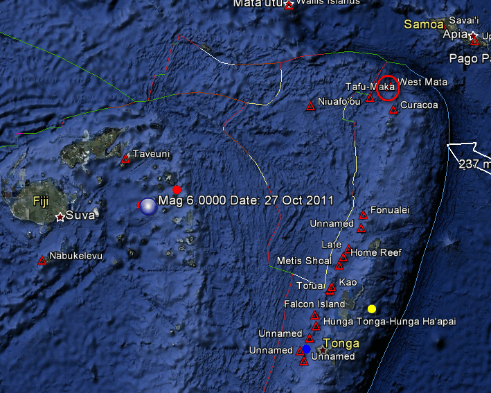
I have marked West Mata as the writing from another name obscures it. The volcano and the quakes are all part of the same subduction (or lens area) and therefore connected. Fiji as you are aware often has very deep quakes in this are, in fact I think I would be right in saying that it has more deep quakes than anywhere else but I need to study that one.
I kind of get the thought that they are due in the next 2-4 months to see precursors for volcano to form
They already have one! One of the deepest underwater volcanoes around and belching out magma at a great rate of knots.
Submarine eruptions account for about three-quarters of all of Earth’s volcanism, but the overlying ocean and the sheer vastness of the seafloor makes detecting and observing them difficult. The only active submarine eruptions that scientists had seen and analyzed until now were at the volcano NW Rota-1, near the island of Guam in the western Pacific
I have marked West Mata as the writing from another name obscures it. The volcano and the quakes are all part of the same subduction (or lens area) and therefore connected. Fiji as you are aware often has very deep quakes in this are, in fact I think I would be right in saying that it has more deep quakes than anywhere else but I need to study that one.
edit on 27/10/2011 by PuterMan because: (no reason given)
reply to post by diamondsmith
Could you possibly explain better what it is that you are trying to say?
The seismo plot to which to referred - Mail Ridge - is showing the earthquake posted by EMSC and USGS.
Forgive me but I just don't understand what your two posts were trying to say?
Could you possibly explain better what it is that you are trying to say?
The seismo plot to which to referred - Mail Ridge - is showing the earthquake posted by EMSC and USGS.
Forgive me but I just don't understand what your two posts were trying to say?
reply to post by diamondsmith
Just because the data is missing from one site that has been down for days does not a conspiracy make!
There are plenty of other sites that do have all the data.
Just because the data is missing from one site that has been down for days does not a conspiracy make!
There are plenty of other sites that do have all the data.
reply to post by PuterMan
Sorry I just saw at that time a big pick on that link..but maybe was nothing..
5.1 ?Quebec?" date: Thu, 27 Oct 2011 12:35:07 +0000 UTC
Initial UX,UY,V,A : 0.091507 -0.019379 10.691 281.957
Observed UX,UY,V,A : 0.058924 -0.046703 13.300 308.400 P
Calibrated UX,UY,V,A : 0.059635 -0.042080 13.701 305.208
Herrin-tab LatLon,Di,Az,H : 56.595 -76.964 42.581 305.208 33.0
Herrin-tab TT, xmag : 472.359 3.594 LOCATE P
Herrin-tab Phase, region : P 443 NORTHERN QUEBEC, CANADA
Magnitudes for Site : NOA_02B00_sz
Using amp(q.u.),per.(s),nm : 4629.61 0.850 26.471
MB : 5.1
Origin time :2011-300:12.21.50.991 482350
Onset time :2011-300:12.29.43.350 Oct 27 Thursday
Detection time :2011-300:12.29.32.000 C054 (CSEM-EMSC)"source
California is quite active.....
Magnitude
3.9
Date-Time
Thursday, October 27, 2011 at 12:36:44 UTC
Thursday, October 27, 2011 at 05:36:44 AM at epicenter
Location
37.873°N, 122.251°W
Depth
9.7 km (6.0 miles)
Region
SAN FRANCISCO BAY AREA, CALIFORNIA
Distances
2 km (1 miles) E (87°) from Berkeley, CA
4 km (3 miles) ESE (118°) from Albany, CA
4 km (3 miles) SSE (147°) from Kensington, CA
9 km (6 miles) NNW (347°) from Oakland, CA
Location Uncertainty
horizontal +/- 0.2 km (0.1 miles); depth +/- 0.4 km (0.2 miles)
Parameters
Nph= 83, Dmin=1 km, Rmss=0.17 sec, Gp= 29°,
M-type=local magnitude (ML), Version=3
Source
California Integrated Seismic Net:
USGS Caltech CGS UCB UCSD UNR
Event ID
nc71671256
earthquake.usgs.gov...
2 (2.9) in Southern California right before that one. Small, I know but still active this morning.edit on 27-10-2011 by MamaJ because: (no reason given)
Magnitude
3.6
Date-Time
Thursday, October 27, 2011 at 12:36:44 UTC
Thursday, October 27, 2011 at 05:36:44 AM at epicenter
Location
37.873°N, 122.251°W
Depth
9.7 km (6.0 miles)
Region
SAN FRANCISCO BAY AREA, CALIFORNIA
Distances
2 km (1 miles) E (87°) from Berkeley, CA
4 km (3 miles) ESE (118°) from Albany, CA
4 km (3 miles) SSE (147°) from Kensington, CA
9 km (6 miles) NNW (347°) from Oakland, CA
Location Uncertainty
horizontal +/- 0.2 km (0.1 miles); depth +/- 0.4 km (0.2 miles)
Parameters
Nph= 83, Dmin=1 km, Rmss=0.17 sec, Gp= 29°,
M-type=regional moment magnitude (Mw), Version=4
Source
California Integrated Seismic Net:
USGS Caltech CGS UCB UCSD UNR
Event ID
nc71671256
Anyhow, what I came on to say was no one has posted this 5.1 in Turkey complete with it's own little aftershock.
It probably just got lost in the mass of them but actually it is different.
EMSC
It is on the Turkey / Iraq border and not by Van, and is right on the plate boundary.
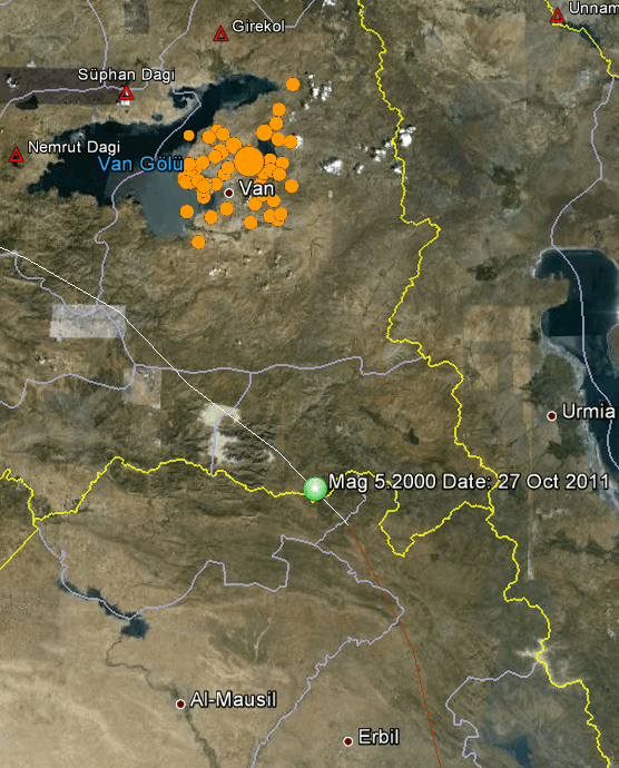
Could this be building for something bigger as that areas moves after stress relief at Van?
ETA: That is 5.2 on the map as that is the USGS value but I needed to list from EMSC as USGS do not have the 3.5
Date/Time UTC,Latitude,Longitude,Magnitude,Depth(Km),Location
2011-10-27 08:17:58, 37.457, 43.927, 3.5, 5.0, Turkey Iraq Border Region
2011-10-27 08:04:22, 37.216, 43.937, 5.1, 10.0, Turkey Iraq Border Region
It probably just got lost in the mass of them but actually it is different.
EMSC
Magnitude mb 5.1
Region TURKEY-IRAQ BORDER REGION
Date time 2011-10-27 08:04:22.0 UTC
Location 37.21 N ; 43.93 E
Depth 10 km
Distances 90 km NE Dahuk (pop 128,776 ; local time 11:04:22.3 2011-10-27)
43 km S Hakkari (pop 77,699 ; local time 11:04:22.3 2011-10-27)
29 km E Çukurca (pop 8,843 ; local time 11:04:22.3 2011-10-27)
It is on the Turkey / Iraq border and not by Van, and is right on the plate boundary.
Could this be building for something bigger as that areas moves after stress relief at Van?
ETA: That is 5.2 on the map as that is the USGS value but I needed to list from EMSC as USGS do not have the 3.5
edit on 27/10/2011 by PuterMan because: (no reason given)
reply to post by PuterMan
If you take 600 miles radius maybe you could determine something but where to put the center of the radius???
reply to post by PuterMan
I actually did see that one and thought about what you said the other day when Turkey had their big un. Didn't you say we need to keep an eye out and if it shifted to the border they may indeed be in for a bigger one? Ha! I could go back on this thread to find out but.....too lazy this morning. I need more coffee. hahaha
I actually did see that one and thought about what you said the other day when Turkey had their big un. Didn't you say we need to keep an eye out and if it shifted to the border they may indeed be in for a bigger one? Ha! I could go back on this thread to find out but.....too lazy this morning. I need more coffee. hahaha
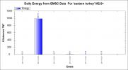
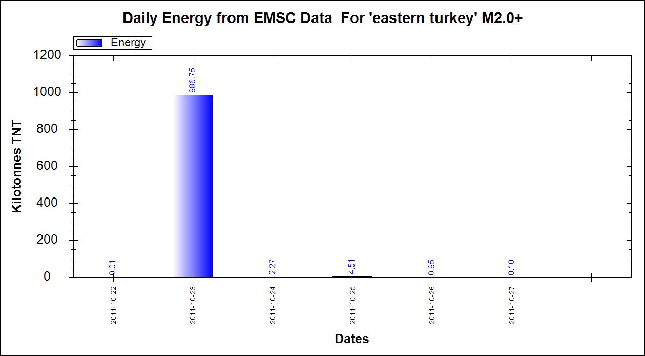
I hope that the daily energy released for Eastern Turkey is a good sign as it appears to be trending downwards. Over half way through the day now and
there is only 0.1 Kilotonnes of TNT released so far. I have noticed that the ones coming through are often sub 3.0 now so fingers crossed for the
people of the area.
edit on 27/10/2011 by PuterMan because: (no reason given)
California anyone?
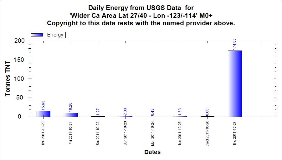
Just playing around with some changes to the program but you may as well see the results if they are interesting. Note the drop off before the 4.6. You would need to see if this was the case around the actual fault line since this is a fairly large spread.
Just playing around with some changes to the program but you may as well see the results if they are interesting. Note the drop off before the 4.6. You would need to see if this was the case around the actual fault line since this is a fairly large spread.
reply to post by PuterMan
earthquake.usgs.gov...
I told you this is strange.What in the world is this???
earthquake.usgs.gov...
I told you this is strange.What in the world is this???
reply to post by diamondsmith
Telemetry error most probably. It is difficult to say as the top of the error is 'off the page' and this is not a publicly available seismo so I can't check another version of it. It is certainly nothing to be concerned about.
Telemetry error most probably. It is difficult to say as the top of the error is 'off the page' and this is not a publicly available seismo so I can't check another version of it. It is certainly nothing to be concerned about.
reply to post by PuterMan
That internal energy what was released there save other sensitive places in last 4 days ..
In nature is we have many similar situations ..
Hope internal pressure was released there enough to have peaceful time in next months worldwide for strong eq ..
We have bad situation in Ca and area of US ..
For my it's now most active or vulnerable area after that very strong internal releases in Turkey, there happen strong eq now is only US with very active pressure without releasing strong earthquake ..
Think next time when internal pressure come to maximum we need to monitory there very closely, specially when external pressure be on maximum like very strong solar storms, supermoon, stronger planetary alignments etc ..
That combination of max internal and some stronger external is most dangerous time or days ..
This 4 days don't have enough internal pressure for stronger eq but external pressure is present ..
Don't want put some fear etc, is only some my research and order of similar situations so I want to post that maybe some one draw something useful from it ..
Peace ..
edit on 27-10-2011 by Dalke07 because: (no reason given)
reply to post by diamondsmith
Where are you sourcing that seismo? I don't see it on the NCA lists
earthquake.usgs.gov...
Note none of these show it.
Where are you sourcing that seismo? I don't see it on the NCA lists
earthquake.usgs.gov...
Note none of these show it.
reply to post by PuterMan
It's under the Tsunami/CREST network. Click on Alaska, from the main USGS seismo page. Or here is a link to the latest data for that network.
Link
About half way down the page
It's under the Tsunami/CREST network. Click on Alaska, from the main USGS seismo page. Or here is a link to the latest data for that network.
Link
About half way down the page
edit on 10/27/2011 by Olivine because: to add info
reply to post by PuterMan
,earthquake.usgs.gov...),It's bookmark but like with the imsal.com..I keep the link bookmarked .hope
you could open it!!
new topics
-
BIDEN Admin Begins Planning For January 2025 Transition to a New President - Today is 4.26.2024.
2024 Elections: 3 hours ago -
Big Storms
Fragile Earth: 4 hours ago -
Where should Trump hold his next rally
2024 Elections: 7 hours ago -
Shocking Number of Voters are Open to Committing Election Fraud
US Political Madness: 7 hours ago -
Gov Kristi Noem Shot and Killed "Less Than Worthless Dog" and a 'Smelly Goat
2024 Elections: 8 hours ago -
Falkville Robot-Man
Aliens and UFOs: 8 hours ago -
James O’Keefe: I have evidence that exposes the CIA, and it’s on camera.
Whistle Blowers and Leaked Documents: 9 hours ago -
Australian PM says the quiet part out loud - "free speech is a threat to democratic dicourse"...?!
New World Order: 10 hours ago -
Ireland VS Globalists
Social Issues and Civil Unrest: 10 hours ago -
Biden "Happy To Debate Trump"
2024 Elections: 11 hours ago
top topics
-
James O’Keefe: I have evidence that exposes the CIA, and it’s on camera.
Whistle Blowers and Leaked Documents: 9 hours ago, 17 flags -
Australian PM says the quiet part out loud - "free speech is a threat to democratic dicourse"...?!
New World Order: 10 hours ago, 15 flags -
Blast from the past: ATS Review Podcast, 2006: With All Three Amigos
Member PODcasts: 13 hours ago, 13 flags -
Biden "Happy To Debate Trump"
2024 Elections: 11 hours ago, 13 flags -
Ireland VS Globalists
Social Issues and Civil Unrest: 10 hours ago, 9 flags -
Mike Pinder The Moody Blues R.I.P.
Music: 13 hours ago, 8 flags -
BIDEN Admin Begins Planning For January 2025 Transition to a New President - Today is 4.26.2024.
2024 Elections: 3 hours ago, 7 flags -
What is the white pill?
Philosophy and Metaphysics: 13 hours ago, 6 flags -
Shocking Number of Voters are Open to Committing Election Fraud
US Political Madness: 7 hours ago, 6 flags -
Big Storms
Fragile Earth: 4 hours ago, 6 flags
active topics
-
James O’Keefe: I have evidence that exposes the CIA, and it’s on camera.
Whistle Blowers and Leaked Documents • 14 • : 19Bones79 -
BIDEN Admin Begins Planning For January 2025 Transition to a New President - Today is 4.26.2024.
2024 Elections • 18 • : rickymouse -
RAAF airbase in Roswell, New Mexico is on fire
Aliens and UFOs • 12 • : pianopraze -
A Warning to America: 25 Ways the US is Being Destroyed
New World Order • 29 • : 19Bones79 -
Big Storms
Fragile Earth • 15 • : Caver78 -
What is the white pill?
Philosophy and Metaphysics • 22 • : AlexandrosOMegas -
University of Texas Instantly Shuts Down Anti Israel Protests
Education and Media • 315 • : CriticalStinker -
Gov Kristi Noem Shot and Killed "Less Than Worthless Dog" and a 'Smelly Goat
2024 Elections • 58 • : cherokeetroy -
Biden "Happy To Debate Trump"
2024 Elections • 51 • : rickymouse -
Hate makes for strange bedfellows
US Political Madness • 53 • : 19Bones79