It looks like you're using an Ad Blocker.
Please white-list or disable AboveTopSecret.com in your ad-blocking tool.
Thank you.
Some features of ATS will be disabled while you continue to use an ad-blocker.

Quake Watch 2011
page: 331share:
Originally posted by muzzy
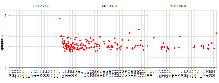
The last big quake on the White Creek Fault (at the southern end 58km away) was the Inangahua 1968 Mag 6.7, which interestingly enough had 6 x Mag 5.0 - 5.7 aftershocks within the first 3 days afterwards and further 6 x Mag 5.0 to 5.4 aftershocks within the 45 days following.[color=F87217] (Hmm, might look into that further, I remember it as a kid, first time helicopters were used to evacuate earthquake victims in NZ, seen it on (Black and White) TV News, about a day later)
Well I did.
Wasn't on the White Creek Fault after all, has its own fault, the Inagnahua Fault.
I got sidetracked yesterday afternoon and put together a bit of info on it for my 1968 page on NZMag5>
Couple of interesting things I found.
This was the last mag 7 on land in NZ before the 2010 Darfield
Back then they were also arguing about types of magnitudes, had 6.7ML to start with, then 7.1Mw or 7.2Mw depending on which report you read, but settled on 7.4Ms.
As has been dicussed on here before about grid patterns (I think it started when the swarm of quakes in Czechoslovakia was happening afew months ago), back in 1968 Geonet just had 2 decimal points to their Lat/Long, so if you click one + in on the aftershock map ( on that linked page) you get a nice tidy grid pattern .
I got to doing this because I was looking for a comparable quake on land about the same size as the Van, Turkey quake the other day, its pretty close, but the fault slip is different, Van being a oblique strike slip and thie Inangahua being reverse strike slip.
heres the aftershock rollout for Inangahua (50hrs) (I marked it as 6.7 on the graph rather than 7.1Mw, as all the aftershocks are in ML)
and the Van graph again (40hrs) (set at 7.1Mw, I can't be bothered changing it back to ML right now, but the same should apply as the Turks use ML and MD too for the aftershocks, I'll fix it later when I update the 48hrs timeline)
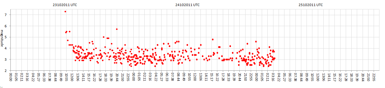
The Van aftershocks are indeed earlier and more intense.
Although back in 1968 they probably had more basic monitoring equipment and missed a few 3's. FWIW the data didn't show any aftershocks less than 2.7 so I'm guessing they did it all from Wellington and didn't have portable siesmographs back then to put in closer, like they do now.
edit on 26-10-2011 by muzzy because: (no reason given)
"By Michael Barajas
Published: October 26, 2011
Late last week, the region’s largest earthquake on record rattled the heart of South Texas oil and gas country, shaking the ground 47 miles southeast of San Antonio in Atascosa County and sending mild tremors as far north as Burnet. But the 4.8 magnitude earthquake also stirred up questions over oilfield activity and whether new processes involved could spark significant, damaging quakes in the future.From New York State to Texas, critics of natural-gas drilling in oil-rich shale formations, using a process known as hydraulic fracturing or “fracking,” have claimed the method, which injects massive amounts of chemical-laden water thousands of feet below the surface, contaminates local groundwater, damages the health of local communities, and may even cause increased seismic activity. While industry insists fracking hasn’t been linked to any instances of groundwater contamination (even though a laundry list of cases test the claim), a growing number of reports link the process to minor earthquakes.Within hours of Thursday’s South Texas quake, British researchers announced two minor earthquakes in northwest England with magnitudes of 2.3 and 1.5 “appeared to correlate closely” with fracking in the region. The Army Corps of Engineers has even requested a 3,000-foot buffer zone for drilling near dams, worried that fracking near fault lines could case earthquakes and geologic shifts that could weaken dams.Central Arkansas, teeming with oil and gas exploration, saw an outbreak of roughly 1,200 earthquakes near an active fault line in 2010 and 2011 — including one magnitude 4.7 — although University of Memphis seismologist Stephen Horton, who studied the Arkansas quakes, said fracking wasn’t to blame, not directly. Rather, he found the injection of chemical-infused fracking wastewater, also known as fracking mud, deep underground was stressing an already active fault. “We saw the earthquakes getting larger and more intense, the seismic activity there was growing,” he said. Some companies voluntarily shut down disposal wells nearest the fault in March 2011 amid fears that more activity could cause larger, more damaging quakes. The state’s oil and gas commission outright banned such disposal wells last month. Still, Horton said, the vast majority of the Arkansas quakes weren’t large enough to be widely felt, let alone cause damage.Another recent study by scientists with Southern Methodist University and the University of Texas at Austin linked fracking wastewater wells with an uptick in small earthquakes rattling the Barnett Shale region near Dallas-Fort Worth. Cliff Frohlich, a UT geophysicist who coauthored the study, said there needs to be more research and monitoring of seismic activity in and around Texas’ oil-shale plays. “When an earthquake big enough or in an urban area like Dallas happens, people feel it and it causes this fracas. But we need to look more systematically to see how common this phenomenon is and where it’s happening,” he said. “It’s in the interest of the public and also the industry – public concern can shut down an industry, even if it’s not warranted.”Following oil and gas exploration that began in the 1950s, long before fracking of the Eagle Ford got underway, the area southeast of San Antonio started to see minor earthquakes as early as the 1970s, occurring mostly within natural gas fields, Frohlich said.
Julie Dutton, a geophysicist with the U.S. Geological Survey, said last week the area has seen more than a dozen earthquakes over the past two decades. “At a 4.8, though, this is of course the largest that we’ve seen,” she said.Still, even before the Eagle Ford boom spiked drilling permits across the region, there have been number of known gas fields buzzing with activity in South Texas for decades, Frohlich said. Frohlich coauthored a study after a magnitude 4.3 earthquake, the region’s previous record-holder, rattled the region in 1993 and suggested the quake was tied to natural gas production. Both the 1993 earthquake and last week’s occurred across the Fashing gas field, just west of Karnes City, which has been actively exploited since the late 1950s — Houston-based Momentum Oil & Gas most recently announced buying up a swath of new property and wells in the Fashing in May. “It’s funny, the analogy I make is like smoking,” Frohlich said. “If your grandfather dies of lung cancer, it’s hard to prove smoking caused it, but on the other hand, you can run statistics for hundreds of people and say, ‘Yea, smokers are much more likely to have lung cancer.’ It’s a lot like that.” Looking southeast of San Antonio, historically most of the area’s earthquakes have occurred in active gas fields, Frohlich said. “We’re unaware of any earthquakes that occurred before gas development began in the 50s, and so a logical person would probably conclude it’s related to that,” he said.Of last week’s earthquake, Frohlich said,"My intuition is that ..."
reply to post by muzzy
Re the Van aftershocks, Muzzy...
Could it be that they are earlier and somewhat more intense simply because the whole region is still very unstable and has to settle? (I mean relatively unstanble.)
Just wondering over it. Because otherwise it makes me think that there could be another fairly major event more or less along the same line but more to the west.
By the way, "Czechoslovakia" doesn't exist and hasn't existed since 1/1/93. It's just called the Czech Republic now... Slovaks have their own.
Mike
"... that there is a relationship, but it's hard to prove."
Link to the original article.
sacurrent.com...
I just think this real important. And people who are having trouble link to the source that I am providing to support my neurotic, obsessive thesis. If you've missed the thrust of my argument, it's that fracking causes quakes.
Here's a slogan. If I actually write down the actual words. I could get in trouble.
_________ is good.
Fracking is bad.
What do you think is is the blank?
Could it be love???
reply to post by Robin Marks
img.abovetopsecret.com...
Is this the pad you are talking about by the 2.7? Looks to me like its in Faulkner County. Not sure of the current status, though.
Hope the link works...
img.abovetopsecret.com...
Is this the pad you are talking about by the 2.7? Looks to me like its in Faulkner County. Not sure of the current status, though.
Hope the link works...
reply to post by dragonlover12
Thank you. It's a well. And they don't always have a pond. It could be conventinal right now. When it starts to run dry, the crack it. Or they're planning on digging a pond and now yet at that stage.
I guess the point is they're fracking and drilling on an active fault.
Since that statement is so absurd all on it's own, how can I continue?
Did anyone notice this one?
Magnitude mb 4.9
Region OWEN FRACTURE ZONE REGION
Date time 2011-10-26 20:31:44.0 UTC
Location 14.31 N ; 54.01 E
Depth 1 km
Distances 301 km S Salalah (pop 163,140 ; local time 00:31:44.4 2011-10-27)
306 km S Taqah (pop 17,827 ; local time 00:31:44.4 2011-10-27)
291 km SE Al-gayd'ah (pop 2,676 ; local time 23:31:44.4 2011-10-26)
Source parameters not yet reviewed by a seismologist
and this one half an hour or so before
Magnitude mb 4.9
Region OWEN FRACTURE ZONE REGION
Date time 2011-10-26 19:54:12.5 UTC
Location 14.34 N ; 53.73 E
Depth 33 km
Distances 300 km S Salalah (pop 163,140 ; local time 23:54:12.5 2011-10-26)
309 km S Taqah (pop 17,827 ; local time 23:54:12.5 2011-10-26)
269 km SE Al-gayd'ah (pop 2,676 ; local time 22:54:12.5 2011-10-26)
Source parameters not yet reviewed by a seismologist
and this one
Magnitude mb 4.0
Region REVILLA GIGEDO ISLANDS REGION
Date time 2011-10-26 16:53:15.0 UTC
Location 19.22 N ; 108.80 W
Depth 10 km
Distances 404 km W Puerto vallarta (pop 187,134 ; local time 11:53:15.0 2011-10-26)
411 km SW Ixtapa (pop 18,717 ; local time 11:53:15.0 2011-10-26)
380 km W Tomatlán (pop 8,360 ; local time 11:53:15.0 2011-10-26)
Source parameters provided by another agency
EMSC
New one on me.
Rainbows
Jane
Magnitude mb 4.9
Region OWEN FRACTURE ZONE REGION
Date time 2011-10-26 20:31:44.0 UTC
Location 14.31 N ; 54.01 E
Depth 1 km
Distances 301 km S Salalah (pop 163,140 ; local time 00:31:44.4 2011-10-27)
306 km S Taqah (pop 17,827 ; local time 00:31:44.4 2011-10-27)
291 km SE Al-gayd'ah (pop 2,676 ; local time 23:31:44.4 2011-10-26)
Source parameters not yet reviewed by a seismologist
and this one half an hour or so before
Magnitude mb 4.9
Region OWEN FRACTURE ZONE REGION
Date time 2011-10-26 19:54:12.5 UTC
Location 14.34 N ; 53.73 E
Depth 33 km
Distances 300 km S Salalah (pop 163,140 ; local time 23:54:12.5 2011-10-26)
309 km S Taqah (pop 17,827 ; local time 23:54:12.5 2011-10-26)
269 km SE Al-gayd'ah (pop 2,676 ; local time 22:54:12.5 2011-10-26)
Source parameters not yet reviewed by a seismologist
and this one
Magnitude mb 4.0
Region REVILLA GIGEDO ISLANDS REGION
Date time 2011-10-26 16:53:15.0 UTC
Location 19.22 N ; 108.80 W
Depth 10 km
Distances 404 km W Puerto vallarta (pop 187,134 ; local time 11:53:15.0 2011-10-26)
411 km SW Ixtapa (pop 18,717 ; local time 11:53:15.0 2011-10-26)
380 km W Tomatlán (pop 8,360 ; local time 11:53:15.0 2011-10-26)
Source parameters provided by another agency
EMSC
New one on me.
Rainbows
Jane
edit on 26-10-2011 by angelchemuel because: (no reason given)
edit on 26-10-2011 by angelchemuel because: (no reason
given)
Hey Mike and Jaded.
Here is a map of crustal thicknesses.
earthquake.usgs.gov...
Here is a map of crustal thicknesses.
earthquake.usgs.gov...
edit on 26-10-2011 by kdog1982 because: (no reason given)
reply to post by angelchemuel
Yep,thanks.
I have been looking at that one and was searching to see if anyone posted it.
Yep,thanks.
I have been looking at that one and was searching to see if anyone posted it.
reply to post by Robin Marks
I'm sure you've seen this, but I was SHOCKED to see that Louisiana had so much! And it's all very close to the Arkansas border.
www.mnn.com... Click to enlarge
I'm sure you've seen this, but I was SHOCKED to see that Louisiana had so much! And it's all very close to the Arkansas border.
www.mnn.com... Click to enlarge
edit on 10/26/2011 by StealthyKat because: (no reason
given)
Earthquake Details
This event has been reviewed by a seismologist.
Magnitude 6.0
Date-Time
Thursday, October 27, 2011 at 00:15:25 UTC
Thursday, October 27, 2011 at 12:15:25 PM at epicenter
Location 17.914°S, 179.424°W
Depth 611.9 km (380.2 miles)
Region FIJI REGION
Distances
568 km (353 miles) NW (309°) from NUKU'ALOFA, Tonga
3159 km (1963 miles) W (265°) from PAPEETE, Tahiti, French Polynesia
Location Uncertainty horizontal +/- 15.9 km (9.9 miles); depth +/- 10.3 km (6.4 miles)
Parameters NST=372, Nph=472, Dmin=268.3 km, Rmss=0.95 sec, Gp= 76°,
M-type=regional moment magnitude (Mw), Version=4
Source
Magnitude: USGS NEIC (WDCS-D)
Location: USGS NEIC (WDCS-D)
Event ID usb0006edd
Source: USGS
VERY deep!
edit on 26/10/2011 by PuterMan because: (no reason given)
reply to post by kdog1982
Yup, check them out here
This has all the PB ones as well.
Nice map by the way. Thanks.
Yup, check them out here
This has all the PB ones as well.
Nice map by the way. Thanks.
edit on 26/10/2011 by PuterMan because: (no reason given)
reply to post by angelchemuel
Seems there is a 19:54 one as well Seems I am just stoopid and can't read. Apologies. I will leave the listing for posterior.
Date/Time UTC,Latitude,Longitude,Magnitude,Depth(Km),Location
2011-10-26 20:31:44, 14.310, 54.016, 4.9, 1.0, Owen Fracture Zone Region
2011-10-26 19:54:12, 14.345, 53.736, 4.9, 33.0, Owen Fracture Zone Region
edit on 26/10/2011 by PuterMan because: (no reason given)
Originally posted by PuterMan
Earthquake Details
This event has been reviewed by a seismologist.
Magnitude 6.0
Date-Time
Thursday, October 27, 2011 at 00:15:25 UTC
Thursday, October 27, 2011 at 12:15:25 PM at epicenter
Location 17.914°S, 179.424°W
Depth 611.9 km (380.2 miles)
Region FIJI REGION
Distances
568 km (353 miles) NW (309°) from NUKU'ALOFA, Tonga
3159 km (1963 miles) W (265°) from PAPEETE, Tahiti, French Polynesia
Location Uncertainty horizontal +/- 15.9 km (9.9 miles); depth +/- 10.3 km (6.4 miles)
Parameters NST=372, Nph=472, Dmin=268.3 km, Rmss=0.95 sec, Gp= 76°,
M-type=regional moment magnitude (Mw), Version=4
Source
Magnitude: USGS NEIC (WDCS-D)
Location: USGS NEIC (WDCS-D)
Event ID usb0006edd
Source: USGS
VERY deep!
edit on 26/10/2011 by PuterMan because: (no reason given)
I saw that come up on my FB from a friend. My initial thought was, 6.0 THAT deep?!?!?!?! My second thought(s) after looking at Google Earth was that they had a earlier hit 6.7 M at 521km in January... I dunno I kind of get the thought that they are due in the next 2-4 months to see precursors for volcano to form. I put a marker in Google Earth to mind me to look and keep an eye on it.
reply to post by JustMike
sorry about the Czech Republic thingy, slow learner here, to me Burma's still Burma not Myanmar and Celyon's still Ceylon not Sri Lanka.
As it happens I had a guy working for me for a few days last week from Slovakia, he was saying he left because after the breakup of Yugoslavia their country has gone to rack and ruin, no work there now, lots of corruption.
Hopefully the Van quake isn't the start of another westward sequence of 7's, they were expecting the next 7 to be at Istanbul (Constantinople to the die hards) but it has gone back eastward instead.
I may have to download Baja data or drag up Christchurch 2010 again and have a look at those as a comparison, the Van quake may "look" worse because the Turks are right on the ball with low magnitude data, if you just used USGS or EMSC data it probably wouldn't have so many events showing.
Will have a look at the first 36 hours of all 3 and see whats up
edit on 26-10-2011 by muzzy because: (no reason given)
I knew it since yesterday,9.60 N 120.47 W 13 Mw 4.8 M NORTHERN CALIFORNIA NEIR
2011-10-27 06:37:09.2 39.60 N 120.47 W 13 M 4.8 M NORTHERN CALIFORNIA NEIR,source (CSEM-EMSC)!!
2011-10-27 06:37:09.2 39.60 N 120.47 W 13 M 4.8 M NORTHERN CALIFORNIA NEIR,source (CSEM-EMSC)!!
Here is the proof,earthquake.usgs.gov... doesn't work but is the Mail RIdge plot!!!
edit on
27-10-2011 by diamondsmith because: Because the link doesn't work.
Hi all,
Just felt a tremor here in the foothills. The LOUD rumble was about 10 - 12 seconds long.
My sons friend who lives in Marysville felt it too, but stated her apartment shook.
anyone else feel that?
Just felt a tremor here in the foothills. The LOUD rumble was about 10 - 12 seconds long.
My sons friend who lives in Marysville felt it too, but stated her apartment shook.
anyone else feel that?
new topics
-
Intro once again
Introductions: 1 hours ago -
University student disciplined after saying veganism is wrong and gender fluidity is stupid
Education and Media: 2 hours ago -
Geddy Lee in Conversation with Alex Lifeson - My Effin’ Life
People: 3 hours ago -
God lived as a Devil Dog.
Short Stories: 3 hours ago -
Police clash with St George’s Day protesters at central London rally
Social Issues and Civil Unrest: 5 hours ago -
TLDR post about ATS and why I love it and hope we all stay together somewhere
General Chit Chat: 6 hours ago -
Hate makes for strange bedfellows
US Political Madness: 8 hours ago -
Who guards the guards
US Political Madness: 10 hours ago
top topics
-
Hate makes for strange bedfellows
US Political Madness: 8 hours ago, 16 flags -
Who guards the guards
US Political Madness: 10 hours ago, 13 flags -
whistleblower Captain Bill Uhouse on the Kingman UFO recovery
Aliens and UFOs: 17 hours ago, 12 flags -
Police clash with St George’s Day protesters at central London rally
Social Issues and Civil Unrest: 5 hours ago, 8 flags -
TLDR post about ATS and why I love it and hope we all stay together somewhere
General Chit Chat: 6 hours ago, 5 flags -
University student disciplined after saying veganism is wrong and gender fluidity is stupid
Education and Media: 2 hours ago, 5 flags -
Has Tesla manipulated data logs to cover up auto pilot crash?
Automotive Discussion: 12 hours ago, 2 flags -
God lived as a Devil Dog.
Short Stories: 3 hours ago, 2 flags -
Geddy Lee in Conversation with Alex Lifeson - My Effin’ Life
People: 3 hours ago, 2 flags -
Intro once again
Introductions: 1 hours ago, 2 flags
active topics
-
Deadpool and Wolverine
Movies • 5 • : WhitewaterSquirrel -
University student disciplined after saying veganism is wrong and gender fluidity is stupid
Education and Media • 12 • : HatesFreshAir -
-@TH3WH17ERABB17- -Q- ---TIME TO SHOW THE WORLD--- -Part- --44--
Dissecting Disinformation • 629 • : fringeofthefringe -
Terrifying Encounters With The Black Eyed Kids
Paranormal Studies • 63 • : Consvoli -
TLDR post about ATS and why I love it and hope we all stay together somewhere
General Chit Chat • 7 • : Consvoli -
Mood Music Part VI
Music • 3089 • : TheWoker -
Intro once again
Introductions • 1 • : Encia22 -
Hate makes for strange bedfellows
US Political Madness • 33 • : DBCowboy -
Breaking Baltimore, ship brings down bridge, mass casualties
Other Current Events • 466 • : IndieA -
Remember These Attacks When President Trump 2.0 Retribution-Justice Commences.
2024 Elections • 45 • : TzarChasm