It looks like you're using an Ad Blocker.
Please white-list or disable AboveTopSecret.com in your ad-blocking tool.
Thank you.
Some features of ATS will be disabled while you continue to use an ad-blocker.

Quake Watch 2011
page: 334share:
Originally posted by diamondsmith
reply to post by PuterMan
Wonder Japan+aftershocks=energy,turkey+aftershocks=energy,Japan how many aftershocks,turkey till now how many aftershocks?
You can't compare a 9.1 with a 7.1 regarding aftershocks, in fact numbers count for nothing when it comes to aftershocks, its all about "quality" (size).
If you are comparing quakes and aftershock sequences you at least have to start with the same sized mainshock, and also set a comparable timeline..
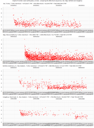
I did my best to compare 4 quakes of about the same size, and chose 72 hours as the timeline, and you can see from the Energy Released ( text above each graph) that number of a/s mean nothing i.e. look at Baja, 2046 aftershocks, but out of all four quakes the least released aftershock energy, because they were so small. Baja didn't have any Mag 5's so that ruined what looks like a monster aftershock sequence.
All up the Baja wins, but only because it was a Mag 7.2 Mainshock.
Its all in the mainshock, thats why we tustle over them here just after they happen, one decimal point either way and the power ( energy released) is reduced/increased by up to 30%
eg.
7.0 476,879 tonnes of TNT
7.1 673,610 tonnes of TNT
7.2 951,499 tonnes of TNT
Heres the Graph of four similar sized earthquakes, on land, comparing the aftershock sequences, Van, Baja, Darfield and Inangahua
thumbnail (but its not linked as the big pic is stored off site)
edit on 27-10-2011 by muzzy because: (no reason given)
Tools used to compile the event files behind the graphs
Van - KOERI events tagged (VAN) or (BITLIS)
Baja - ANSS Catalog Search Start date,time: 2010/04/04, End date,time: 201004/08, Min magnitude: 2.0 Min latitude: 31.75, Max latitude: 33, Min longitude: -116, Max longitude: -114
Darfield - GeonetQuakesearch From (UTC) Year 2010 Month Sep Day 3, To (UTC) Year 2010, Month Sep, Day 6, S Latitude -44, N Latitude -43, W Longitude 171.5, E Longitude 173.26, Min Magnitude 2.0
Inangahua - GeonetQuakesearch From (UTC) Year 1968, Month May, Day 23, To (UTC) Year1968, Month May, Day 26, S Latitude -42.2, N Latitude -41.3, W Longitude 171.5, E Longitude 172.3 Min Magnitude 2.0
Intially I downloaded USGS NIEC data 90km radius circular search for Baja 90km but the minimum mag was 2.7 and about half as many events so went to ANSS.
Also ran Haiti 7.0 through both ANSS and USGS NEIC , max number of events I got was 68 , so gave that a
edit on 27-10-2011 by muzzy because:
(no reason given)
Scientific American have an
interesting blog on Van tectonics. I started reading it, then decided it was way to complex for my tired little brain. I put the pic of the fault
lines up on the tv screen but it's still hard to define.
Good morning Peeps.
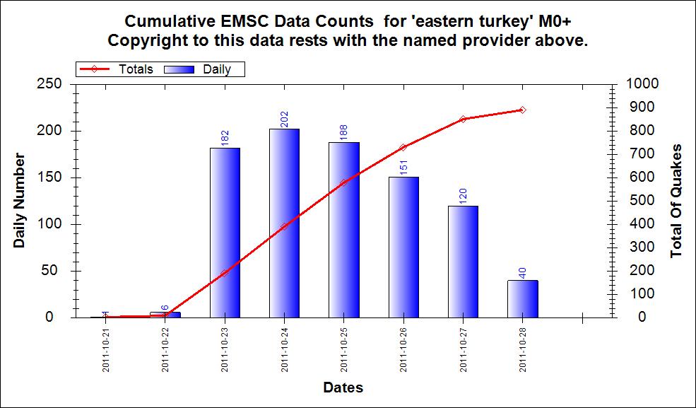
Turkey count of numbers. Yesterday was fewer quakes so this looks as if it is following a normal shock/aftershock pattern.
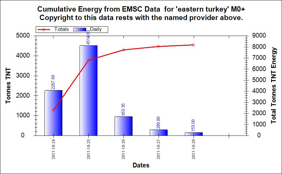
And the energy
Turkey count of numbers. Yesterday was fewer quakes so this looks as if it is following a normal shock/aftershock pattern.
And the energy
reply to post by muzzy
Interesting. Using your parameters I got a listing form my database, which is effectively any quakes issued over a 7 day period.
The number of lines returned was 1600 which mean 400+ quakes have been added to ANSS after the 7 day period!
As I steadfastly maintain, numbers do not matter. The only thing that matters is the energy release. I think that one of the problems is that people do not have a concept of the energy so you will no doubt have notice that for public display I have moved over to TNT as at least people have some idea of what that is. For most a petajoule
Baja - ANSS Catalog Search Start date,time: 2010/04/04, End date,time: 201004/08, Min magnitude: 2.0 Min latitude: 31.75, Max latitude: 33, Min longitude: -116, Max longitude: -114
Interesting. Using your parameters I got a listing form my database, which is effectively any quakes issued over a 7 day period.
The number of lines returned was 1600 which mean 400+ quakes have been added to ANSS after the 7 day period!
number of a/s mean nothing
As I steadfastly maintain, numbers do not matter. The only thing that matters is the energy release. I think that one of the problems is that people do not have a concept of the energy so you will no doubt have notice that for public display I have moved over to TNT as at least people have some idea of what that is. For most a petajoule
edit on 28/10/2011 by PuterMan because: (no reason given)
reply to post by Robin Marks
Not going to belabour this Robin but I think you missed the point. One should not apply any such epithets to mental illness.
A crazy amount of aftershocks has no association with mental illness. The word crazy has no association with mental illness as far as I am concerned.
Not going to belabour this Robin but I think you missed the point. One should not apply any such epithets to mental illness.
A crazy amount of aftershocks has no association with mental illness. The word crazy has no association with mental illness as far as I am concerned.
Region: SOUTH OF AUSTRALIA
Geographic coordinates: 40.633S, 126.422E
Magnitude: 4.7 Mb
Depth: 10 km
Universal Time (UTC): 28 Oct 2011 09:08:37
Time near the Epicenter: 28 Oct 2011 17:08:37
Local standard time in your area: 28 Oct 2011 19:38:37
Location with respect to nearby cities:
1242 km (772 miles) SW (236 degrees) of Adelaide, Australia
2071 km (1287 miles) WSW (247 degrees) of CANBERRA, Australia
usgs
Weird place.
edit on 28-10-2011 by zenius because: link
reply to post by PuterMan
Nice work man,wonder why intense activity between September and March,could be the gravitational attraction between the planets and sun or the
intense changes of the temperature between the surface,plates and magma?or both...But let's watch this movie named"West Coast"!!!
Speaking of West Coast. I thought of her this morning as I saw the two Earthquakes from Oklahoma this morning. If I remember correctly her attention
was focused on that state however I cannot remember why (mind must be getting old).
This one is bigger than the last (3.3) earthquake.usgs.gov...
This one is bigger than the last (3.3) earthquake.usgs.gov...
Magnitude
3.5
Date-Time
Friday, October 28, 2011 at 09:18:46 UTC
Friday, October 28, 2011 at 04:18:46 AM at epicenter
Time of Earthquake in other Time Zones
Location
35.532°N, 97.366°W
Depth
5 km (3.1 miles)
Region
OKLAHOMA CITY URBAN AREA, OKLAHOMA
Distances
15 km (9 miles) ENE of OKLAHOMA CITY, Oklahoma
34 km (21 miles) N of Norman, Oklahoma
39 km (24 miles) S of Guthrie, Oklahoma
46 km (28 miles) WNW of Shawnee, Oklahoma
Location Uncertainty
horizontal +/- 14.4 km (8.9 miles); depth +/- 2.1 km (1.3 miles)
Parameters
NST= 35, Nph= 45, Dmin=149.2 km, Rmss=0.46 sec, Gp= 61°,
M-type="Nuttli" surface wave magnitude (mbLg), Version=6
Source
Magnitude: USGS NEIC (WDCS-D)
Location: USGS NEIC (WDCS-D)
Event ID
usb0006fgu
[Date: Fri, 28 Oct 2011 11:28:46 +0000 UTC
Autoloc alert gfz2011vczf: determined by 41 stations, weight 41, type A
LocSAT solution (with start solution, 41 stations used, weight 41):
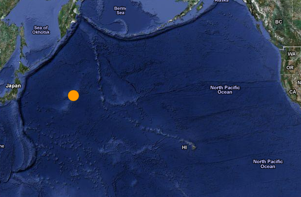
North Pacific Ocean M=5.8 2011/10/28 11:14:24.2 35.18 N 158.63 E 10 km]http://www.emsc-csem.org/Earthquake/seismologist.php?view=1
Sorry to ask but what is USGS?
Autoloc alert gfz2011vczf: determined by 41 stations, weight 41, type A
LocSAT solution (with start solution, 41 stations used, weight 41):
North Pacific Ocean M=5.8 2011/10/28 11:14:24.2 35.18 N 158.63 E 10 km]http://www.emsc-csem.org/Earthquake/seismologist.php?view=1
Sorry to ask but what is USGS?
Originally posted by diamondsmith
[Snip]
Sorry to ask but what is USGS?
Are you serious? You started a thread where you predict a possible mag 8.3 quake for Greece during the following week from the Turkey quake -- based on your "calculation" -- and now you say you don't know what the USGS is? The US Geological Survey?
Mike
edit on 28/10/11 by JustMike because: added a much needed smiley.
2011-10-28 11:06:58.0 28.56 S 175.93 W 35 M 5.4 M KERMADEC ISLANDS REGION NEIR
Magnitude 5.4
Date-Time
Friday, October 28, 2011 at 11:06:58 UTC
Friday, October 28, 2011 at 11:06:58 PM at epicenter
Time of Earthquake in other Time Zones
Location 28.559°S, 175.929°W
Depth 35.5 km (22.1 miles)
Region KERMADEC ISLANDS REGION
Distances 207 km (128 miles) ENE of Raoul Island, Kermadec Islands
428 km (265 miles) NE of L'Esperance Rock, Kermadec Islands
825 km (512 miles) S of NUKU`ALOFA, Tonga
1267 km (787 miles) NE of Auckland, New Zealand
earthquake.usgs.gov...
This is listing from, www.emsc-csem.org...
Many station report this eq but usgs did not, one eq around M 5.9 MIX ..
2011-10-28 11:14:27.7 33.96 N 154.93 E 27 mb 5.7 A NORTH PACIFIC OCEAN SC3
2011-10-28 11:14:24.2 35.18 N 158.63 E 10 M 5.8 A NORTH PACIFIC OCEAN GFZ
2011-10-28 11:14:18.1 A NORTH PACIFIC OCEAN LJU
2011-10-28 11:14:10.0 25.35 N 148.52 E 1 mb 5.9 A EAST OF THE VOLCANO ISLANDS MSO
2011-10-28 11:13:55.7 21.38 N 155.13 E 164 mb 5.9 A NORTH PACIFIC OCEAN BEO
2011-10-28 11:13:52.7 32.15 N 173.31 W 33 mb 6.0 A NORTH PACIFIC OCEAN LDG
2011-10-28 11:13:50.1 31.54 N 172.88 W 33 mb 6.1 A HAWAIIAN ISLANDS REGION LDG
2011-10-28 11:13:50.1 28.44 N 165.22 E 15 A NORTH PACIFIC OCEAN ZAMG
edit on 28-10-2011 by Dalke07 because: (no reason given)
reply to post by JustMike
Looks like he's using EMSC.
That's ok, we're all here to learn...now he knows about usgs I'm sure he will gain greatly.
Looks like he's using EMSC.
That's ok, we're all here to learn...now he knows about usgs I'm sure he will gain greatly.
reply to post by Dalke07
That list looks like a whole lot of
confusion
IRIS doesn't have it either, Puterman's QVS does.
That list looks like a whole lot of
confusion
IRIS doesn't have it either, Puterman's QVS does.
edit on 28-10-2011 by zenius because: add
reply to post by zenius
I was having a gentle dig. He even posted a link to a USGS-hosted seismogram here in his own thread two days ago, so I am sincerely hoping that his question was in jest.
Anyhow, I added a smiley in to my post so he knows I'm responding to what I suspect is a little joke on his part.
Mike
I was having a gentle dig. He even posted a link to a USGS-hosted seismogram here in his own thread two days ago, so I am sincerely hoping that his question was in jest.
Anyhow, I added a smiley in to my post so he knows I'm responding to what I suspect is a little joke on his part.
Mike
edit on 28/10/11 by JustMike because: (no reason given)
reply to post by Dalke07
2011-10-28 11:14:27.7 33.96 N 154.93 E 27 mb 5.7 A NORTH PACIFIC OCEAN SC3 2011-10-28 11:14:24.2 35.18 N 158.63 E 10 M 5.8 A NORTH PACIFIC OCEAN GFZ 2011-10-28 11:14:18.1 A NORTH PACIFIC OCEAN LJU 2011-10-28 11:14:10.0 25.35 N 148.52 E 1 mb 5.9 A EAST OF THE VOLCANO ISLANDS MSO 2011-10-28 11:13:55.7 21.38 N 155.13 E 164 mb 5.9 A NORTH PACIFIC OCEAN BEO 2011-10-28 11:13:52.7 32.15 N 173.31 W 33 mb 6.0 A NORTH PACIFIC OCEAN LDG 2011-10-28 11:13:50.1 31.54 N 172.88 W 33 mb 6.1 A HAWAIIAN ISLANDS REGION LDG 2011-10-28 11:13:50.1 28.44 N 165.22 E 15 A NORTH PACIFIC OCEAN ZAMG
That is a lot of North Pacific Ocean Eq's Dalke!! Is all of them from today and you are saying USGS doesn't have them listed? They don't .....I just checked but neither does the other link from EMSC. I am confused.
reply to post by Dalke07
Yes, as Zenius says, that list for the mystery North Pacific 5.8 (??) quake is all over the place. The EMSC has plenty of data on it but I think they're having trouble pinning down the precise location and magnitude. Could be a while before it gets put on the official list -- assuming, of course, that it was actually a quake and not something else.
There are other energy sources that could generate a strong enough trace to register on seismos in that mag range, after all. They're just rather rare.
Mike
reply to post by JustMike
Oh, yes, sorry forgot....aussie humour.
It's not just the energy output, but also the long/lat coordinates they can't seem to agree on.
Be careful, Mike, now you'll get all the conspiracy nuts going on about what caused the trace...
Oh, yes, sorry forgot....aussie humour.
It's not just the energy output, but also the long/lat coordinates they can't seem to agree on.
Be careful, Mike, now you'll get all the conspiracy nuts going on about what caused the trace...
reply to post by MamaJ
Hi MamaJ,
apparently, all that data is different possible locations/times/mags for one quake event. This is probably why it's not made it onto the official lists and maps yet. They have to work out the most precise time, location and magnitude.
It's an unusual location (relatively) and that could be adding to the issue.
Mike
reply to post by JustMike
Yap was a joke but still asking?Maybe they are aware of hiding something wasn't there a CME few days ago?So what is SOHO?
new topics
-
BIDEN Admin Begins Planning For January 2025 Transition to a New President - Today is 4.26.2024.
2024 Elections: 3 hours ago -
Big Storms
Fragile Earth: 5 hours ago -
Where should Trump hold his next rally
2024 Elections: 8 hours ago -
Shocking Number of Voters are Open to Committing Election Fraud
US Political Madness: 8 hours ago -
Gov Kristi Noem Shot and Killed "Less Than Worthless Dog" and a 'Smelly Goat
2024 Elections: 9 hours ago -
Falkville Robot-Man
Aliens and UFOs: 9 hours ago -
James O’Keefe: I have evidence that exposes the CIA, and it’s on camera.
Whistle Blowers and Leaked Documents: 10 hours ago -
Australian PM says the quiet part out loud - "free speech is a threat to democratic dicourse"...?!
New World Order: 11 hours ago -
Ireland VS Globalists
Social Issues and Civil Unrest: 11 hours ago
top topics
-
James O’Keefe: I have evidence that exposes the CIA, and it’s on camera.
Whistle Blowers and Leaked Documents: 10 hours ago, 17 flags -
Australian PM says the quiet part out loud - "free speech is a threat to democratic dicourse"...?!
New World Order: 11 hours ago, 15 flags -
Blast from the past: ATS Review Podcast, 2006: With All Three Amigos
Member PODcasts: 14 hours ago, 13 flags -
Biden "Happy To Debate Trump"
2024 Elections: 12 hours ago, 13 flags -
Ireland VS Globalists
Social Issues and Civil Unrest: 11 hours ago, 10 flags -
Mike Pinder The Moody Blues R.I.P.
Music: 14 hours ago, 8 flags -
BIDEN Admin Begins Planning For January 2025 Transition to a New President - Today is 4.26.2024.
2024 Elections: 3 hours ago, 7 flags -
What is the white pill?
Philosophy and Metaphysics: 14 hours ago, 6 flags -
Shocking Number of Voters are Open to Committing Election Fraud
US Political Madness: 8 hours ago, 6 flags -
Big Storms
Fragile Earth: 5 hours ago, 6 flags
active topics
-
-@TH3WH17ERABB17- -Q- ---TIME TO SHOW THE WORLD--- -Part- --44--
Dissecting Disinformation • 703 • : 777Vader -
University of Texas Instantly Shuts Down Anti Israel Protests
Education and Media • 316 • : Schmoe3755 -
Gov Kristi Noem Shot and Killed "Less Than Worthless Dog" and a 'Smelly Goat
2024 Elections • 63 • : GENERAL EYES -
Mood Music Part VI
Music • 3113 • : MRTrismegistus -
BIDEN Admin Begins Planning For January 2025 Transition to a New President - Today is 4.26.2024.
2024 Elections • 20 • : BustedBoomer -
One Flame Throwing Robot Dog for Christmas Please!
Weaponry • 12 • : worldstarcountry -
RAAF airbase in Roswell, New Mexico is on fire
Aliens and UFOs • 13 • : Ophiuchus1 -
President BIDEN's FBI Raided Donald Trump's Florida Home for OBAMA-NORTH KOREA Documents.
Political Conspiracies • 40 • : BingoMcGoof -
Australian PM says the quiet part out loud - "free speech is a threat to democratic dicourse"...?!
New World Order • 7 • : 19Bones79 -
It takes One to Be; Two to Tango; Three to Create.
Philosophy and Metaphysics • 8 • : Compendium