It looks like you're using an Ad Blocker.
Please white-list or disable AboveTopSecret.com in your ad-blocking tool.
Thank you.
Some features of ATS will be disabled while you continue to use an ad-blocker.

Quake Watch 2011
page: 337share:
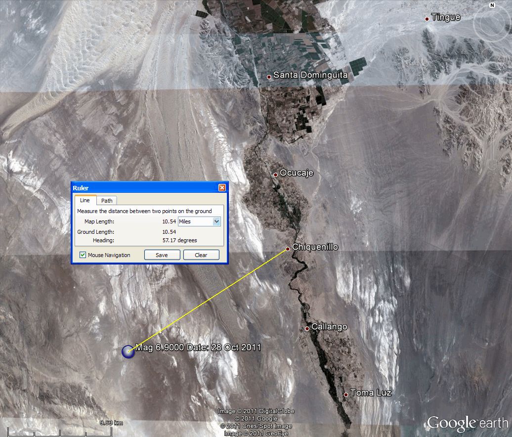
Originally posted by PuterMan
reply to post by MamaJ
Probably 6.9 looking at Geofon.
Folks this is a YELLOW PAGER ALERT event
earthquake.usgs.gov...
Yes it is!!! And according to the map there are a lot of people who live in the area. I sure hope everyone is ok. I was thinking it was more off the coast than what it actually is.
edit on 28-10-2011 by MamaJ because: (no reason given)
fast aftershock[ate: Fri, 28 Oct 2011 19:29:18 +0000 UTC
Autoloc alert gfz2011vdox: determined by 19 stations, weight 19, type M
LocSAT solution (with start solution, 19 stations used, weight 19):
Near Coast of Peru M=5.2 2011/10/28 19:10:35.7 14.66 S 76.36 W 22 km]http://www.emsc-csem.org/Earthquake/alert/?id=KAL43;GFZ&date=2011-10-28
Autoloc alert gfz2011vdox: determined by 19 stations, weight 19, type M
LocSAT solution (with start solution, 19 stations used, weight 19):
Near Coast of Peru M=5.2 2011/10/28 19:10:35.7 14.66 S 76.36 W 22 km]http://www.emsc-csem.org/Earthquake/alert/?id=KAL43;GFZ&date=2011-10-28
Originally posted by diamondsmith
fast aftershock[ate: Fri, 28 Oct 2011 19:29:18 +0000 UTC
Autoloc alert gfz2011vdox: determined by 19 stations, weight 19, type M
LocSAT solution (with start solution, 19 stations used, weight 19):
Near Coast of Peru M=5.2 2011/10/28 19:10:35.7 14.66 S 76.36 W 22 km]http://www.emsc-csem.org/Earthquake/alert/?id=KAL43;GFZ&date=2011-10-28
I don't see a listed aftershock yet....just Eastern Turkey(4) and now one small one in Greece on EMSC....still nothing on USGS in regards to aftershock.
reply to post by diamondsmith
Isn't that according to just one network though which is GFZ? I really wish other networks would get with the program.
Isn't that according to just one network though which is GFZ? I really wish other networks would get with the program.
Originally posted by TribeOfManyColours
reply to post by MamaJ
hisz.rsoe.hu... When you zoom in on this map it doesnt seem populated
Yeah it doesn't seem like it but apparently it is. I am off to see if there is any news feed so we can tell if there is any loss of life because of this possibly 7 mag eq.
ETA: Seems like people were panicked and running in the streets. I always like to see what the area is saying and this site is good for that. They update regularly so stay tuned to this site if you are concerned for the people in the area.
earthquake-report.com...
edit on 28-10-2011 by MamaJ because: (no reason
given)
reply to post by MamaJ
If it is, then i hope damage is minimal. I don't know how the structure of the way they build home's there are designed to take something like this, lets hope for the best
If it is, then i hope damage is minimal. I don't know how the structure of the way they build home's there are designed to take something like this, lets hope for the best
wonder where those two are[Date: Fri, 28 Oct 2011 19:11:08 +0000 UTC
Autoloc alert beo2011vdfg: determined by 14 stations, type A
LocSAT solution (with start solution, 14 stations used, weight 14):
North Atlantic Ocean mb=5.6 2011/10/28 18:58:56.3 17.30 N 41.44 W 10 km.......Date: Fri, 28 Oct 2011 19:15:37 +0000 UTC
Autoloc alert beo2011vdfl: determined by 13 stations, type A
LocSAT solution (with start solution, 13 stations used, weight 13):
North Atlantic Ocean mb=5.5 2011/10/28 19:03:35.6 19.89 N 39.77 W 10 km]http://www.emsc-csem.org/Earthquake/alert/?id=KAL56;BEO&date=2011-10-28
reply to post by TribeOfManyColours

Zoom in with GE rather than Google Maps. That never gets close enough. There are a whole raft of towns/cities above that as well.
Zoom in with GE rather than Google Maps. That never gets close enough. There are a whole raft of towns/cities above that as well.
reply to post by diamondsmith
I am wondering as well. They are not on the listings, and along with the North Pacific one earlier I am wondering what they are picking up?
It seems only EMSC has them. The North Pacifc one made it to the lists and got deleted. Looks as if these never got there.
I suspect that these two are probably erroneous readings from the Peru quake.
edit on 28/10/2011 by PuterMan because: (no reason given)
reply to post by Tzavros
Different system.
USGS PAGER is still Yellow
From the GDACS link.
Don't think much of the quality of their data. You see plain as a pike staff there are two town closer than that.
From USGS PAGER linked above
Different system.
USGS PAGER is still Yellow
The nearest populated places are Faro del Infiernillo (20km). It is a mountainous region with a maximum altitude of 3356 m.
From the GDACS link.
Don't think much of the quality of their data. You see plain as a pike staff there are two town closer than that.
From USGS PAGER linked above
Selected Cities Exposedfrom GeoNames Database of Cities with 1,000 or more residents.
MMI City Population
VI Santiago 10k
VI Ica 247k
VI Hacienda Vista Alegre 10k
VI Subtanjalla 9k
VI San Juan Bautista 7k
VI Los Aquijes 8k
IV Huancavelica 42k
IV Lima 7,737k
III Ayacucho 140k
III Huancayo 377k
III Callao 813k
edit on 28/10/2011 by PuterMan because: (no reason given)
reply to post by PuterMan
That's what I thought, thanks for clarifying. Has there been any aftershocks yet? I can't see any at all yet.
That's what I thought, thanks for clarifying. Has there been any aftershocks yet? I can't see any at all yet.
reply to post by diamondsmith
Yes because they are errors.
May I remind you of what it says on those pages.
www.emsc-csem.org...
(Emphasis by me)
In other words "this information may be bad and if you don't know what you are doing with it you should not be doing anything with it at all, and you certainly should not be telling others"
Yes because they are errors.
May I remind you of what it says on those pages.
This page provides information for use by seismologists. The information contained is of uncertain quality and should not be reported or linked to from other websites.
The hypocentral coordinates and magnitude estimates are obtained using the data available at the time of the estimate. New data or analyses may change the actual estimates of the earthquake location and magnitude. Earthquake parameters may be derived through automatic analysis, and no further quality check is done by EMSC.
EMSC does not provide any implicit or explicit guarantee. Any risk derived from the improper use of the data is assumed by the user.
www.emsc-csem.org...
(Emphasis by me)
In other words "this information may be bad and if you don't know what you are doing with it you should not be doing anything with it at all, and you certainly should not be telling others"
This is what earthquake-report.com... is saying about the Peru Earthquake.
Update : The last deadly earthquake in the area was in 2007, which killed more than 500 people
Update : The MMI VI zones below are at risk for damages and at least minor injuries
Update : MMI values for nearby locations (K= 1000 inhabitants)
VI Santiago 10k
VI Ica 247k
VI Hacienda Vista Alegre 10k
VI Subtanjalla 9k
VI San Juan Bautista 7k
VI Los Aquijes 8k
IV Huancavelica 42k
IV Lima 7,737k
III Ayacucho 140k
III Huancayo 377k
III Callao 813k
Update : The earthquake is also reported to be felt in Arequipa, Cusco and Pisco, where many citizens refused to go back in their homes. The quake has caused power outages in many locations.
Update : Damage is expected in Ica because more than 3,000 houses are built of mud. Rescue groups are on their way to the affected area.
Update : The earthquake was felt with great intensity in Canete, Chincha, Huancavelica and Cuzo Huamanga. There are reports of smaller aftershocks felt in Huancavelica and Huamanga.
Update : earthquakes are very common in this area but are rarely tis powerful
Update : This earthquake is a subduction earthquake, which means that the Nazca plate (oceanic plate) is subducting the South American plate. Sometimes the gliding is not smooth enough and the plates are cracking with the accumulated energy. This event makes these massive earthquakes.
Update : Panicked people rushed into the streets. The earthquake was well felt in Lima too
Update : Earthquake-report.com is labeling this earthquake as EXTREMELY DANGEROUS
Update : USGS has calculated that the max. MMI is VII (very strong shaking) which will be experienced by 373 people only, however 334,000 people will have felt a strong shaking
Update : Ica is a city with 247,000 inhabitants (latest census)
Update : The earthquake happened right on the coastline near Ica, Peru
latino.foxnews.com... is saying everyone is panicking but no injuries reported so
far. They also say in the article that the jolt only lasted 30 seconds so not as near the intensity as the one that killed 66,000 in 1970. So....good
news so far.
Re Peru
Another cliff-hanger eh
I don't think its a 7.0, well maybe, oh I don't know
1. Peru has it at 6.7ML
based on Turkey, Inangahua and Darfield ML it might make 7.0Mw on conversion, but of course the geology in Peru is different
www.igp.gob.pe... (took ages for the page toload for me, and the link to the event page doesn't work)
2. Its not showing anywhere near as much trace as the Turkey quake did on LISS SNZO, despite being half the distance away, or only 1/4 of a World away compared with 1/2 a World
aslwww.cr.usgs.gov... (I'll grab a screenshot in a couple of hours once the trace moves up a bit)
SNZO 23102011 showing Turkey quake
ETA
Couple of Aftershocks
geofon.gfz-potsdam.de...
Geofon's got the handle on this one, others are way behind
Another cliff-hanger eh
I don't think its a 7.0, well maybe, oh I don't know
1. Peru has it at 6.7ML
2011-10-28 18:54:25 14.78 76.53 30 6.7 V Ica, Nazca
based on Turkey, Inangahua and Darfield ML it might make 7.0Mw on conversion, but of course the geology in Peru is different
www.igp.gob.pe... (took ages for the page toload for me, and the link to the event page doesn't work)
2. Its not showing anywhere near as much trace as the Turkey quake did on LISS SNZO, despite being half the distance away, or only 1/4 of a World away compared with 1/2 a World
aslwww.cr.usgs.gov... (I'll grab a screenshot in a couple of hours once the trace moves up a bit)
SNZO 23102011 showing Turkey quake
ETA
Couple of Aftershocks
2011-10-28 19:10:35 5.2 14.66°S 76.36°W 22 M Near Coast of Peru
2011-10-28 20:26:48 4.9 14.61°S 76.44°W 10 A Near Coast of Peru
geofon.gfz-potsdam.de...
Geofon's got the handle on this one, others are way behind
edit on 28-10-2011 by muzzy because: (no reason given)
Forgot to mention yesterday, USGS are still not showing any Phase Data for Baja 2010 quake
I wonder why?
earthquake.usgs.gov...
I wonder why?
earthquake.usgs.gov...
new topics
-
Las Vegas UFO Spotting Teen Traumatized by Demon Creature in Backyard
Aliens and UFOs: 7 minutes ago -
2024 Pigeon Forge Rod Run - On the Strip (Video made for you)
Automotive Discussion: 56 minutes ago -
Gaza Terrorists Attack US Humanitarian Pier During Construction
Middle East Issues: 1 hours ago -
The functionality of boldening and italics is clunky and no post char limit warning?
ATS Freshman's Forum: 2 hours ago -
Meadows, Giuliani Among 11 Indicted in Arizona in Latest 2020 Election Subversion Case
Mainstream News: 3 hours ago -
Massachusetts Drag Queen Leads Young Kids in Free Palestine Chant
Social Issues and Civil Unrest: 3 hours ago -
Weinstein's conviction overturned
Mainstream News: 4 hours ago -
Supreme Court Oral Arguments 4.25.2024 - Are PRESIDENTS IMMUNE From Later Being Prosecuted.
Above Politics: 6 hours ago -
Krystalnacht on today's most elite Universities?
Social Issues and Civil Unrest: 6 hours ago -
Chris Christie Wishes Death Upon Trump and Ramaswamy
Politicians & People: 6 hours ago
top topics
-
Krystalnacht on today's most elite Universities?
Social Issues and Civil Unrest: 6 hours ago, 8 flags -
Weinstein's conviction overturned
Mainstream News: 4 hours ago, 6 flags -
Supreme Court Oral Arguments 4.25.2024 - Are PRESIDENTS IMMUNE From Later Being Prosecuted.
Above Politics: 6 hours ago, 5 flags -
University of Texas Instantly Shuts Down Anti Israel Protests
Education and Media: 8 hours ago, 5 flags -
Massachusetts Drag Queen Leads Young Kids in Free Palestine Chant
Social Issues and Civil Unrest: 3 hours ago, 4 flags -
Meadows, Giuliani Among 11 Indicted in Arizona in Latest 2020 Election Subversion Case
Mainstream News: 3 hours ago, 4 flags -
Chris Christie Wishes Death Upon Trump and Ramaswamy
Politicians & People: 6 hours ago, 2 flags -
Any one suspicious of fever promotions events, major investor Goldman Sachs card only.
The Gray Area: 11 hours ago, 2 flags -
Gaza Terrorists Attack US Humanitarian Pier During Construction
Middle East Issues: 1 hours ago, 2 flags -
2024 Pigeon Forge Rod Run - On the Strip (Video made for you)
Automotive Discussion: 56 minutes ago, 1 flags
active topics
-
Candidate TRUMP Now Has Crazy Judge JUAN MERCHAN After Him - The Stormy Daniels Hush-Money Case.
Political Conspiracies • 779 • : Vermilion -
Supreme Court Oral Arguments 4.25.2024 - Are PRESIDENTS IMMUNE From Later Being Prosecuted.
Above Politics • 60 • : Annee -
University of Texas Instantly Shuts Down Anti Israel Protests
Education and Media • 183 • : Threadbarer -
Las Vegas UFO Spotting Teen Traumatized by Demon Creature in Backyard
Aliens and UFOs • 0 • : FlyersFan -
Breaking Baltimore, ship brings down bridge, mass casualties
Other Current Events • 489 • : Threadbarer -
-@TH3WH17ERABB17- -Q- ---TIME TO SHOW THE WORLD--- -Part- --44--
Dissecting Disinformation • 679 • : McTech2 -
Gaza Terrorists Attack US Humanitarian Pier During Construction
Middle East Issues • 15 • : Irishhaf -
Massachusetts Drag Queen Leads Young Kids in Free Palestine Chant
Social Issues and Civil Unrest • 9 • : theatreboy -
Meadows, Giuliani Among 11 Indicted in Arizona in Latest 2020 Election Subversion Case
Mainstream News • 5 • : Disgusted123 -
God's Righteousness is Greater than Our Wrath
Religion, Faith, And Theology • 29 • : Topcraft