It looks like you're using an Ad Blocker.
Please white-list or disable AboveTopSecret.com in your ad-blocking tool.
Thank you.
Some features of ATS will be disabled while you continue to use an ad-blocker.

Quake Watch 2011
page: 329share:
reply to post by diamondsmith
Have never seen it like this,
not that I know how to read it.
Could you tell us what you
see here? Also, is there a
link or program that tells
how to read the graphs?
I always feel left behind when
I see these, even tho I can
tell is looks active.
Have never seen it like this,
not that I know how to read it.
Could you tell us what you
see here? Also, is there a
link or program that tells
how to read the graphs?
I always feel left behind when
I see these, even tho I can
tell is looks active.
reply to post by crazydaisy
Thanks to Olivine she give us a link,there you can find day to hour data,as about reading use USGS and Applied math!
reply to post by diamondsmith
Have to say my friend that there is not one signature on that which looks like an earthquake.
I don't think I can pull a waveform for that but I know what I would hear if I listened to it. I will see if I can get one.
ETA: I can get a waveform for that so I will download one. In the meantime look at a different version of the same thing.
MEGW.UW..BHZ
That looks like engines to me, as for example you see at PAYL where the trains run past. I am also currently investigating A04D which exhibits the same features and is right next to s channel where boats pass.
edit on 25/10/2011 by PuterMan because: (no reason given)
reply to post by PuterMan
Could be though this is happening for weeks so....they should be there before.I think that the margins are not high for what you are say to
be!Think how all could begin...trains and boats through their throats...
reply to post by diamondsmith
I have had a listen, and I consider this to be heavy engines. Looking on GE I can see that coastal container ships use the area.
Unfortunately the signal is very broken (probably the solar blast) so it has been extremely difficult to find a section that has a complete 'pattern' in it. This is the closest I can get
UW_MEGW_SNZ_20111025-163722_500sps.wav
That is at 10x speed.
In addition the pattern exhibits classic cultural noise traits of being most apparent from 1100 UTC to 2400 UTC, so from 0400 to 1700 (?) for this area which definitely puts it in line for being cultural. On top of that it has the classic 'not normally there on Sunday' feature as well, which for me pin-pints it as being man made.
reply to post by PuterMan
Oh yeah, I did have trouble putting the links in, tried to do it by typing the code rather than using the button
didn't work, obviously
will try harder next time ( at least check it before moving on )
Oh yeah, I did have trouble putting the links in, tried to do it by typing the code rather than using the button
didn't work, obviously
will try harder next time ( at least check it before moving on )
reply to post by diamondsmith
There really is not any similarity between those signals at all in any way shape of form. Starting with the sound, the Japan sound is played a at 100 times speed, so lets hear the one I put up before at 100x instead of 10x speed as it was.
UW_MEGW_SNZ_20111025-163722_5000sps.wav
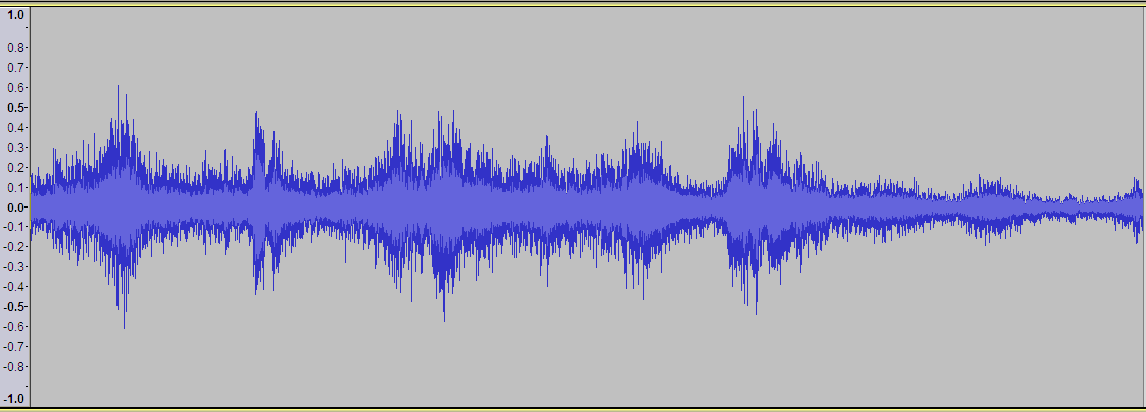
Then there is the waveform. Top Japan, bottom MEGW
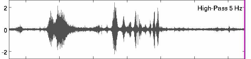
No that does not look anything like, so let's take a look at the spectrum.
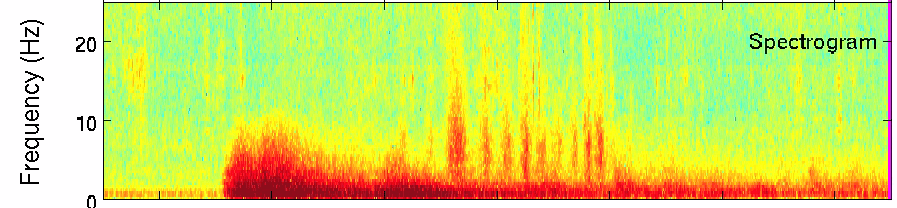
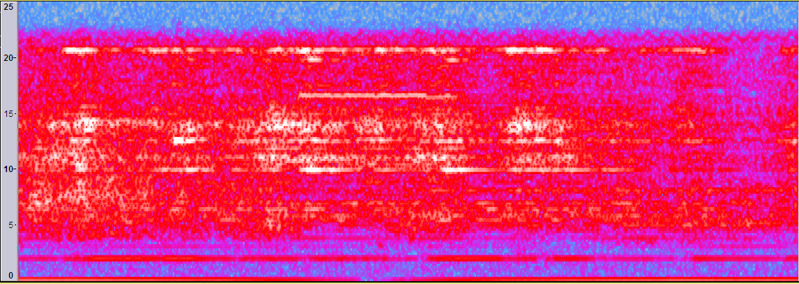
Now with the best will in the world that just is NOT the same type of signal. For a start the Japan spectrum is heavily below 5 Hz (partially because of the 5 Hz filter) where as MEGW has little or no content below 5 Hz and if I was to high pass filter on 5 Hz there would be nothing left.
Chalk and cheese, but thanks for the link to the Japan data and sound.
There really is not any similarity between those signals at all in any way shape of form. Starting with the sound, the Japan sound is played a at 100 times speed, so lets hear the one I put up before at 100x instead of 10x speed as it was.
UW_MEGW_SNZ_20111025-163722_5000sps.wav
Then there is the waveform. Top Japan, bottom MEGW
No that does not look anything like, so let's take a look at the spectrum.
Now with the best will in the world that just is NOT the same type of signal. For a start the Japan spectrum is heavily below 5 Hz (partially because of the 5 Hz filter) where as MEGW has little or no content below 5 Hz and if I was to high pass filter on 5 Hz there would be nothing left.
Chalk and cheese, but thanks for the link to the Japan data and sound.
edit on 25/10/2011 by PuterMan because: (no reason given)
Arizona anyone???
Magnitude
3.6
Date-Time
Tuesday, October 25, 2011 at 18:20:24 UTC
Tuesday, October 25, 2011 at 11:20:24 AM at epicenter
Location
34.814°N, 112.539°W
Depth
5 km (3.1 miles)
Region
ARIZONA
Distances
10 km (6 miles) NW (307°) from Chino Valley, AZ
11 km (7 miles) SSW (207°) from Paulden, AZ
15 km (10 miles) N (357°) from Williamson, AZ
132 km (82 miles) N (349°) from Peoria, AZ
287 km (178 miles) ESE (122°) from Las Vegas, NV
Location Uncertainty
horizontal +/- 14.7 km (9.1 miles); depth +/- 3.1 km (1.9 miles)
Parameters
NST= 17, Nph= 17, Dmin=131.4 km, Rmss=0.79 sec, Gp= 68°,
M-type=local magnitude (ML), Version=5
Source
Magnitude: USGS NEIC (WDCS-D)
Location: USGS NEIC (WDCS-D)
Event ID
usb0006czh
earthquake.usgs.gov...
reply to post by diamondsmith
Great link! Was going to reply yesterday, but I got swept up in Robin's video of the 'Big Wave', & then got company!
geosurvey.state.co.us...
A lot of information in there that's new to me, pages 6 & 7 especially. I can't believe that they've known since the 1960's that injection causes earthquakes!!! And being able to turn them off & on! The chart that compares Rocky Mountain Arsenal to Trinidad is interesting.
*********Spoiler Alert********* Robin don't read this, you will get more upset! You've probably seen it before, how many barrels a day they were injecting even back then! (1981?) Don't refresh your memory! Fair warning!
The chart they show with differences & similarities is really apples to oranges.
Rocky Mountain Arsenal used as high as 550 psi pressure, in rock, up to 3X the depth & up to 2X the amount of fluid / day, of Trinidad.
Trinidad, gravity fed, in sand, at times 1/3 the depth, & 1/2 the amount of fluid /day!
Not really a fair comparison, but very interesting.
I also didn't know that only 14 states have experienced an earthquake larger than M 6.0. (2002 stats) Bait...anybody game?
AFP - Quake survivors protest backlash against Kurds
25/10/2011 5:07 pm
www.muscatdaily.com/Archive/Gcc/Quake-survivors-protest-backlash-against-Kurds
Barzani donates $1 million for quake victims, help offers continue
25 October 2011, Tuesday / TODAY'S ZAMAN, ANKARA
www.todayszaman.com/news-260888-barzani-donates-1-million-to-turkeys-kizilay-for-quake-victims.html
25/10/2011 5:07 pm
www.muscatdaily.com/Archive/Gcc/Quake-survivors-protest-backlash-against-Kurds
Dozens of survivors in the quake-hit Turkish city of Van hurled stones at journalists and police on Tuesday after some reports hailed the tremor as payback for a recent Kurdish rebel attack.
(...)
Barzani donates $1 million for quake victims, help offers continue
25 October 2011, Tuesday / TODAY'S ZAMAN, ANKARA
www.todayszaman.com/news-260888-barzani-donates-1-million-to-turkeys-kizilay-for-quake-victims.html
Massoud Barzani, the leader of northern Iraq's autonomous Kurdish government, donated $1 million to the Turkish Red Crescent (Kızılay) on Tuesday for the victims of a deadly earthquake that hit eastern Turkey on Sunday.
News reports said a delegation from the Kurdistan Democratic Party (KDP), led by Barzani, visited the Turkish Consulate in Arbil early Tuesday and expressed solidarity with quake victims in the eastern Turkish province of Van. The delegation presented the Turkish consulate general with a $1 million check to be delivered to Kızılay.
(...)
edit on 25-10-2011 by jjjtir because: (no reason given)
Ho Hum another dreary Spring Day, 60kmph winds, drizzle turning to rain in the afternoon., no work today
Oh well, some time to do some more geology study at the desk
I was having a look at these two quakes and thought I would share
Two Mag 4.5 quakes yesterday UTC in New Zealand, one in the NE North Island (moderately deep) and one in the NW South Island (shallow). One had 3 aftershocks (the shallow one), the other didn't have any(the deep one).
Interactive NZ Map
The Max MMIntensity recorded of the shallow SI one was MM4, the deep NI one, was MM5
Why? You would think it would be the other way around eh.?
So I had a closer look at the geology of the two different areas.
The Quakes/Geology comparison
[color=F76541]Lake Waikaremoana Area, North Island
4.52ML, 3599623, -38.67447, 177.1405, 2011/10/24 17:15:19, 45, N of Lake Waikareiti, Urewera National Park 4195, Energy Released 90.867 tonnes of TNT
Epicenter east of the Waimana Fault which is a dextral (right handed) fault with a recurrence Interval of 2000-3500 years and slip rate of 1 -10mmyr
The geology (lithology) of the area where the quake occured is Calcareous sandstone and siltstone (partly alternating with graded sandstone), pumiceous and andesitic tuff, limestone, of Early Miocene age, whereas on the west of the Fault the geology is Sandstone and siltstone (partly alternating with graded sandstone), dark argillite, minor spilitic tuff and lava of Early Cretaceous age (146 to 100 million years ago)
[color=78C7C7]Kahurangi National Park, South Island
4.497ML, 3599335, -41.31572, 172.39122, 2011/10/24 4:30:60, 5, N of Mt. Kendall, Kahurangi National Park 7893, 83.928 tonnes of TNT
and 2 aftershocks
2.489ML, 3599336, -41.31299, 172.40227, 2011/10/24 4:38:37, 5, N of Mt. Kendall, Kahurangi National Park 7893, 0.082 tonnes of TNT
3.35ML, 3599340, -41.30635, 172.38499, 2011/10/24 4:49:43, 5, N of Mt. Kendall, Kahurangi National Park 7893,1.597 tonnes of TNT
Total energy released 85.607 tonnes of TNT
Epicenterswere between the White Creek fault which is a reverse (dip-slip, or up and down) and the Karamea Fault (no data) the geology is predominantly granite and granodiorite; quartz diorite, diorite, aplite of Devonian-Cretaceous age (359-416 mya to 146 mya) .
The last big quake on the White Creek Fault (at the southern end 58km away) was the Inangahua1968 Mag 6.7, which interestingly enough had 6 x Mag 5.0 - 5.7 aftershocks within the first 3 days afterwards and further 6 x Mag 5.0 to 5.4 aftershocks within the 45 days following. (Hmm, might look into that further, I remember it as a kid, first time helicopters were used to evacuate earthquake victims in NZ, seen it on (Black and White) TV News, about a day later)
So sandstone (NI one) allows the shock wave to travel to the surface (to the intruments) with more intensity, despite having to travel 40km further up than the SI quake.
The SI quake which only had 5km to travel, was through granite, and had aftershocks so there was more fracturing?
Makes sense.
or maybe the difference is in the extra 5.26 tonnes of TNT @ the NI one
raises more questions than it answered.
[color=00FF00]sources:
NZFaults DataBase (DB web Map)
Geological Map of NZ (Interactive Map)
Geonet Quake Search
Geological Time Scale (wiki)
edit on 25-10-2011 by muzzy because: (no reason given)
Arkansas ringing in. Definately 2.5M ish. I'm guessing more than 3M. Depends on location. Will post when it shows up on list.
reply to post by Robin Marks
Robin, it was big enough for a few things to fall from shelves here between Hot Springs and Little Rock.
No noise with this one here.
Robin, it was big enough for a few things to fall from shelves here between Hot Springs and Little Rock.
No noise with this one here.
reply to post by dragonlover12
MAP 2.7 2011/10/25 23:24:52 35.360 -92.266 6.1 5 km ( 3 mi) WSW of Quitman, AR
MAP 2.7 2011/10/25 23:24:52 35.360 -92.266 6.1 5 km ( 3 mi) WSW of Quitman, AR
reply to post by jjjtir
Thanks for the image......doesn't seem like they get them often. Definitely cracka lackin'!!
Just saw Arkansas too....and noticed New Madrid had a couple of small ones yesterday.
I'm aware...what can I say.
Thanks for the image......doesn't seem like they get them often. Definitely cracka lackin'!!
Just saw Arkansas too....and noticed New Madrid had a couple of small ones yesterday.
I'm aware...what can I say.
following what we know, when should we see turkey aftershocks slow down?
i know they will continue for ages but im talking about the rate they are happening.
these guys are getting earthquakes like they are being fired from a gattling gun.
i know they will continue for ages but im talking about the rate they are happening.
these guys are getting earthquakes like they are being fired from a gattling gun.
reply to post by ShortMemory
The 4's should taper off in about a month or two to one or two a day, with the odd Mag 5 thrown in to frazzle peoples nerves, the Mag 3 's will go on for 12-18 months, possibly longer as Turkey gets a lot of 3's anyway, 2's ? well I guess until the next big one.
Based on similar sized Mag 6.6ML ( 7.0 - 7.3Mw )quakes on land elsewhere in the world.
Van reminds me of Baja a bit, but I didn't save any data for Baja so can't compare directly.
reply to post by muzzy
Muzzy - I'm thinking out loud here = When envisioning hitting sandstone etal in comparison with hitting granite etal with a hammer = I see the sandstone etal cracking with an easier strike then fracture and having crumbs and dust - whereas granite etal would have to have a more serious blow to crack, then fracture and have sharp edge chips with no crumbs/dust.
So then, the density of the of the subject rock must have an effect of course of the quakes. I would imagine that you would experience more liquefaction in an area with the sandstone etal than the granite etal.
new topics
-
BIDEN Admin Begins Planning For January 2025 Transition to a New President - Today is 4.26.2024.
2024 Elections: 3 hours ago -
Big Storms
Fragile Earth: 5 hours ago -
Where should Trump hold his next rally
2024 Elections: 8 hours ago -
Shocking Number of Voters are Open to Committing Election Fraud
US Political Madness: 8 hours ago -
Gov Kristi Noem Shot and Killed "Less Than Worthless Dog" and a 'Smelly Goat
2024 Elections: 9 hours ago -
Falkville Robot-Man
Aliens and UFOs: 9 hours ago -
James O’Keefe: I have evidence that exposes the CIA, and it’s on camera.
Whistle Blowers and Leaked Documents: 10 hours ago -
Australian PM says the quiet part out loud - "free speech is a threat to democratic dicourse"...?!
New World Order: 11 hours ago -
Ireland VS Globalists
Social Issues and Civil Unrest: 11 hours ago
top topics
-
James O’Keefe: I have evidence that exposes the CIA, and it’s on camera.
Whistle Blowers and Leaked Documents: 10 hours ago, 17 flags -
Australian PM says the quiet part out loud - "free speech is a threat to democratic dicourse"...?!
New World Order: 11 hours ago, 15 flags -
Blast from the past: ATS Review Podcast, 2006: With All Three Amigos
Member PODcasts: 14 hours ago, 13 flags -
Biden "Happy To Debate Trump"
2024 Elections: 12 hours ago, 13 flags -
Ireland VS Globalists
Social Issues and Civil Unrest: 11 hours ago, 10 flags -
Mike Pinder The Moody Blues R.I.P.
Music: 14 hours ago, 8 flags -
BIDEN Admin Begins Planning For January 2025 Transition to a New President - Today is 4.26.2024.
2024 Elections: 3 hours ago, 7 flags -
What is the white pill?
Philosophy and Metaphysics: 13 hours ago, 6 flags -
Shocking Number of Voters are Open to Committing Election Fraud
US Political Madness: 8 hours ago, 6 flags -
Big Storms
Fragile Earth: 5 hours ago, 6 flags
active topics
-
-@TH3WH17ERABB17- -Q- ---TIME TO SHOW THE WORLD--- -Part- --44--
Dissecting Disinformation • 703 • : 777Vader -
University of Texas Instantly Shuts Down Anti Israel Protests
Education and Media • 316 • : Schmoe3755 -
Gov Kristi Noem Shot and Killed "Less Than Worthless Dog" and a 'Smelly Goat
2024 Elections • 63 • : GENERAL EYES -
Mood Music Part VI
Music • 3113 • : MRTrismegistus -
BIDEN Admin Begins Planning For January 2025 Transition to a New President - Today is 4.26.2024.
2024 Elections • 20 • : BustedBoomer -
One Flame Throwing Robot Dog for Christmas Please!
Weaponry • 12 • : worldstarcountry -
RAAF airbase in Roswell, New Mexico is on fire
Aliens and UFOs • 13 • : Ophiuchus1 -
President BIDEN's FBI Raided Donald Trump's Florida Home for OBAMA-NORTH KOREA Documents.
Political Conspiracies • 40 • : BingoMcGoof -
Australian PM says the quiet part out loud - "free speech is a threat to democratic dicourse"...?!
New World Order • 7 • : 19Bones79 -
It takes One to Be; Two to Tango; Three to Create.
Philosophy and Metaphysics • 8 • : Compendium