It looks like you're using an Ad Blocker.
Please white-list or disable AboveTopSecret.com in your ad-blocking tool.
Thank you.
Some features of ATS will be disabled while you continue to use an ad-blocker.

Quake Watch 2011
page: 326share:
reply to post by zenius
You have to uninstall first until this is out of Beta.
Transfer any further queries here please rathe than me cluttering up quake watch.
www.abovetopsecret.com...
You have to uninstall first until this is out of Beta.
Transfer any further queries here please rathe than me cluttering up quake watch.
www.abovetopsecret.com...
Interesting that this shows what I assume are three different defaults, or is this just rounding. Maybe.
As about energy hard to say.... Nuclear Test Sites
From 1945 until 1998, there have been over 2,000 nuclear tests conducted worldwide.
Click on a red square to learn more about that nuclear test site.
Amchitka Island, Alaska, USA
Site of three underground nuclear tests in the 1960's and early 1970s, the Amchitka facility was closed in 1971.
Pacific Ocean
Site of various French nuclear tests.
Nevada Test Site, Nevada, USA
Established by President Truman in 1950 and now operated by the Department of Energy, the NTS has been the site of over 900 atmospheric and underground nuclear tests.
Fallon, Nevada
Site of an American test.
Trinity Site, New Mexico, USA
Site of first nuclear weapon test on July 16, 1945.
Carlsbad, New Mexico
Site of an American test.
Green Valley, CO
Site of an American nuclear test.
Rifle, CO
Site of a American nuclear test.
Hattiesburg, Mississippi
Site of several American tests.
Open Sea, South Atlantic Ocean
Site of three American nuclear rocket tests in 1958.
Reggan, Sahara Desert, Algeria
The first French nuclear device was detonated at Reggan on February 13, 1960. At the time, Algeria was a protectorate of France.
Ekker, Algeria
Site of French testing.
Novaya Zemlya Island, C.I.S.
Site of extensive Soviet atmospheric and underground testing, Novaya Zemlya was the site of the largest thermonuclear device ever tested, a 58 megaton bomb detonated on October 23, 1961.
Semipalatinsk, C.I.S.
Site of hundreds of Soviet atmospheric and underground nuclear tests. Also the site of the first Soviet nuclear test on August 29, 1949.
Prince Edward Island, Indian Ocean
Site of the South African/Israeli nuclear test.
Lop Nur, Western China
Primary nuclear test site. Site of the first Chinese atomic explosion on October 16, 1964 and first Chinese thermonuclear detonation on December 27, 1968.
Chagai Hills, Baluchistan, Pakistan
Site of the first Pakistani nuclear detonations on May 28, 1998.
Pokharan, Rajastan Desert, India
Site of the first Indian nuclear detonation on May 18, 1974. This bomb was exploded 100 meters beneath the surface. The site of the 5 nuclear tests in 1998.
Monte Bello Islands, Australia
Site of the first British nuclear weapons tests in 1952. Used for atmospheric tests until 1956.
Nagasaki, Japan
Site of the second nuclear weapon used in wartime. The Nagasaki bomb, Fat Man, was dropped three days after the bomb on Hiroshima, on August 9, 1945. It is yield was about 22 kilotons.
Hiroshima, Japan
Site of the first nuclear weapon used in wartime. The Hiroshima bomb, Little Boy, was dropped on August 6, 1945. It is yield was about 12 kilotons.
Emu Field, Australia
Site of two British nuclear weapons tests.
Maralinga and Woomera Test Sites, Australia
Used in the 1950's by the British for atmospheric testing.
Eniwetok Atoll, Marshall Islands
Administered by the U.S., this island was used for nuclear testing in the late 1940's and 50's. Eniwetok was the site of the world's first thermonuclear detonation MIKE in 1952.
Bikini Atoll, Marshall Islands
Administered by the U.S., this island was used for nuclear testing in the late 1940's and 50's. Bikini Atoll was the site of BRAVO test.
Johnston Island
Administered by the United States. Site of a number of tests during the late 1950's and early 1960's.
Pacific Ocean
Site of American testing.
CEP , Mururoa and Fangatau Atolls, French Polynesia
(Le Centre d' experimentation du Pacifique) Operated by the French, the CEP is used for nuclear testing. Site of first French thermonuclear device on August 24, 1968.
Christmas Island, Kiribati
Used for British and American nuclear testing in the 1950's and early 1960's. Site of the first British thermonuclear detonation on May 15, 1957.
Related Products
Related Sections
Nuclear Testing Yields
Nuclear Testing Chronology
Nuclear Testing Locations
Related Reading
Atomic Audit: The Costs and Consequences of U. S. Nuclear Weapons Since 1940
by Stephen Schwartz (Editor)
Related Sites
Natural Resources Defense Council
More from the UK. Starting to sit up and take notice of what's happening around Caernarfon now.....but then that's just me
2011/10/24 00:24:45.7 53.193 -4.290 16 1.0 CAERNARFON,GWYNEDD
2011/10/22 08:54:16.4 52.632 -2.867 12 1.1 SHREWSBURY,SHROPS 10KM SW OF SHREWSBUR
From BGS
Rainbows
Jane
2011/10/24 00:24:45.7 53.193 -4.290 16 1.0 CAERNARFON,GWYNEDD
2011/10/22 08:54:16.4 52.632 -2.867 12 1.1 SHREWSBURY,SHROPS 10KM SW OF SHREWSBUR
From BGS
Rainbows
Jane
Hello knowledgable quake watchers
I was wondering if anyone else thought the lack of aftershocks from the 20 Oct 2011, m4.8 Texas earthquake was strange?
I searched for a similiar quake to compare and found this mid Texas EQ from September:
This Rotan series was smaller magnitude, yet still had aftershocks. Does it sometimes happen that a small/moderate quake, in a relatively stable continental area, occurs as a one-off event? Just curious. It's only been 4 days--maybe there is more on the way?
I was wondering if anyone else thought the lack of aftershocks from the 20 Oct 2011, m4.8 Texas earthquake was strange?
I searched for a similiar quake to compare and found this mid Texas EQ from September:
Source of above data
MAG DATE LOCAL-TIME LAT LON DEPTH LOCATION
y/m/d h:m:s deg deg km
2.5 2011/09/13 02:21:35 32.797N 100.842W 5.1 36 km (22 mi) W of Rotan, TX
3.4 2011/09/12 09:18:34 32.822N 100.871W 7.9 39 km (24 mi) W of Rotan, TX
2.7 2011/09/12 04:26:12 32.688N 100.863W 5.0 23 km (14 mi) ESE of Forsan, TX
2.6 2011/09/12 04:19:46 32.787N 100.858W 4.8 37 km (23 mi) W of Rotan, TX
2.3 2011/09/11 21:29:30 32.693N 100.860W 5.3 34 km (21 mi) N of Colorado City, TX
2.8 2011/09/11 19:31:49 32.810N 100.892W 4.3 40 km (25 mi) W of Rotan, TX
2.7 2011/09/11 15:31:58 32.892N 100.848W 5.0 36 km (22 mi) W of Rotan, TX
2.5 2011/09/11 13:36:34 32.887N 100.807W 5.0 32 km (20 mi) W of Rotan, TX
4.4 2011/09/11 07:27:45 32.874N 100.804W 10.3 32 km (20 mi) W of Rotan, TX
2.5 2011/07/14 05:29:13 32.945N 100.821W 4.9 35 km (22 mi) WNW of Rotan, TX
This Rotan series was smaller magnitude, yet still had aftershocks. Does it sometimes happen that a small/moderate quake, in a relatively stable continental area, occurs as a one-off event? Just curious. It's only been 4 days--maybe there is more on the way?
edit on 10/24/2011 by Olivine because: to add source link
reply to post by Olivine
Basically it is my impression that you get few if any aftershocks from an injection/fracking induced earthquake, but Robin may have info on that score.
Basically it is my impression that you get few if any aftershocks from an injection/fracking induced earthquake, but Robin may have info on that score.
reply to post by diamondsmith
I think you are possibly misunderstanding me.
What I was asking was are the percentages based on magnitudes or released energy because it would need to be released energy to be relevant I feel. Since you have not linked your source for those figures I can't go look see for myself.
I think you are possibly misunderstanding me.
What I was asking was are the percentages based on magnitudes or released energy because it would need to be released energy to be relevant I feel. Since you have not linked your source for those figures I can't go look see for myself.
reply to post by diamondsmith
Nuclear test..Now that makes since...So lets kill the earth..Wow..Thank you for the info I didn't know Nevada had anything like this..(nuclear testing)
Nuclear test..Now that makes since...So lets kill the earth..Wow..Thank you for the info I didn't know Nevada had anything like this..(nuclear testing)
reply to post by PuterMan
Thanks for your reply PM--I'm curious to read what Robin thinks.
Diamondsmith, I read your link--thanks for that.
geosurvey.state.co.us...
I whole-heartedly agree that fluid injection causes quakes--is that what you wanted me to get? That document states that Mag 4+ injection-induced quakes in Colorado were followed by thousands of small tremors.
I haven't seen any reported aftershocks from this past Thursday's Mag 4.8 in Texas. Maybe there have been microseisms, that just aren't reported. I can't seem to find a close station to monitor.
reply to post by Olivine
I have a love-hate relationship with the concept of foreshock, mainshock, and aftershock.
"How soon is now?" The Texas earthquake isn't acting normal because it's not. It's artificial. Synthesized. So, it's characteristics are abnormal. There are no plates grinding past each other. There is no ancient fault groaning because it's being squeezed. It is either a new crack, or it is an ancient fault that's been reawakened. There could be no aftershocks because it was a total rupture. Like a balloon popping. One big bang.
Please turn down the volume on your computer. I am now screaming. I will not put on the Caps Lock. But know that I am hysterical and screaming at the top of my soul. Warning. When excited, I will use profanity.
Mother, umm, mother ma. Fracking. Rudd Muckers. I love you all.
It is hard for me to focus on Texas, Oklahoma, etc. I am convinced that fracking and injection are the cause. But that's not the epicenter. That's not where the real danger lies.
There has been two recent quakes in Arkansas. So what right? They've had an average of two a day for the last few weeks. And so what. They're a little north of the "main faultline" As Scott Ausbrook states, the new quakes, which are leftovers- aftershocks- from the old swarm which was caused by injections, they are at the northern tip of the 10 mile long fault. Now I'm giggling. Because I'm manical. If I don't laugh- I cry. Crying hurts my head. Then I'll get a migraine.
These two newest aftershocks are even further north. Shut up robin. So what?
The fault is longer than thought. It is not 10 miles long. It is 15 miles long. Longer by one third. Like the "new-ancient fault" found near Marrianna, I suspect the maxium of the Arkansas manmade fault is 7M.
So. So What>>?>?? So muther fruck what. sososososososoososoosoososoosoososooso
That means the citizens of Arkansas are sitting on a mid-continental fault which has the capacity of prodcuing a 7M earthquake. And.............. Th
They are fracking right on top of it. Connect the dots. It's really child's play. There is no doubt about what's going to happen.
Now. I'm shaking. Now I'm manic. Now i'm me.
No advice. That's my new request. I'm having a meltdown. But I'm damned strong and damned stubborn. I know this rant will mystify you if nothing else. Don't worry. Be happey,. Dododododoooodoodoodododododododododddoo
I am Ok.
Arkansas is not...
reply to post by Robin Marks
No advice. That's my new request. I'm having a meltdown. But I'm damned strong and damned stubborn. I know this rant will mystify you if nothing else. Don't worry. Be happey,. Dododododoooodoodoodododododododododddoo I am Ok. Arkansas is not...
HAHAHA!!!
Robin,
You crack me up (pun intended)
I'm sorry to say I love watching you talk yourself out of having a melt down.
This is serious and I know your heart is in it 100%. Being powerless over fracking can be a hell, especially when you know in your heart it is not only wrong, but the implications are HUGE!
((((HUGS))))) for ya!!!!
On the up again?
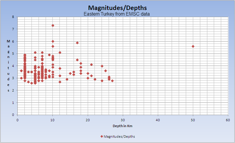
Magnitude mb 5.0
Region EASTERN TURKEY
Date time 2011-10-24 15:28:09.0 UTC
Location 38.80 N ; 43.39 E
Depth 15 km
Distances 34 km NW Van (pop 371,713 ; local time 18:28:09.3 2011-10-24)
26 km S Ercis (pop 91,915 ; local time 18:28:09.3 2011-10-24)
Source parameters reviewed by a seismologist
EMSC
Rainbows
Jane
I"m sure this isn't the first time you guys have seen this:
USGS
How often does this happen?
This is a computer-generated message -- this event has not yet been reviewed by a seismologist.
Magnitude
? (uncertain or not yet determined)
Date-Time
Monday, October 24, 2011 at 17:42:13 UTC
Monday, October 24, 2011 at 10:42:13 AM at epicenter
Location
37.106°N, 119.980°W
Depth
9.3 km (5.8 miles)
Region
CENTRAL CALIFORNIA
Distances
14 km (9 miles) NE (39°) from Madera Acres, CA
18 km (11 miles) NNE (26°) from Madera, CA
19 km (12 miles) NNE (12°) from Parksdale, CA
40 km (25 miles) NNW (335°) from Fresno, CA
171 km (106 miles) E (98°) from San Jose City Hall, CA
Location Uncertainty
horizontal +/- 1 km (0.6 miles); depth +/- 1 km (0.6 miles)
Parameters
Nph= 19, Dmin=8 km, Rmss=0.37 sec, Gp= 83°,
M-type="Nuttli" surface wave magnitude (mbLg), Version=0
Source
California Integrated Seismic Net:
USGS Caltech CGS UCB UCSD UNR
Event ID
nc71669821
USGS
How often does this happen?
reply to post by jadedANDcynical
You talking 'bout the question mark? California automatically posts quakes. It happens frequently.
You talking 'bout the question mark? California automatically posts quakes. It happens frequently.
reply to post by jadedANDcynical
Hi J&C,
yes -- as Robin says, it happens quite often. I often have the USGS map just set to "worldwide" and when I see one of the little "crossed squares" come up I click on it then take a guess at what the number will be. This time I guessed a 2.5. I wuz ronng... I came in at a 2.2.
Seems to me that it mainly happens with little quakes, though. I am not sure why that is.
Robin, forgive me for putting your name in such bright color but wanted to be better sure you might see this. Hope that makes modicums of sense.
I'm concerned about the Gulf of Mexico (GOM). I recall that occasionally there are quakes there that get up around a mag 5.0 but usually few or no aftershocks from them. (Someone please correct me if wrong. Not having good day for personal reasons and I might sound a bit odd.)
Any thoughts why that might be? I ask because I'm thinking of possible connections between GOM seismic activity and the southern US states, perhaps even up into the regions closer to the NMZ.
And please, anyone can respond. I dont mind. Just it worries me, you see. The GOM. I don't like what I think about it. Sorry. I'll shuddup now.
Mike
edit on 24/10/11 by JustMike because: anyone can respond. That's it.
reply to post by JustMike
Hello Mike,
In searching for rare Gulf of Mexico quakes I found only this ?
news.nationalgeographic.com...
Not sure if it will help much. Hope you feel better soon.
Hello Mike,
In searching for rare Gulf of Mexico quakes I found only this ?
The magnitude 6.0 temblor, centered about 330 miles (530 kilometers) southeast of New Orleans, Louisiana, occurred at 8:56 a.m. local time (map of Louisiana). It was felt in parts of Florida, Georgia, Alabama, Louisiana, and Mississippi.
news.nationalgeographic.com...
Not sure if it will help much. Hope you feel better soon.
reply to post by LorraineRKO
Yes I remember that one
Was in the first year of my quakewatching disease
2006 EQ Blog Sept 11
A one off, and no aftershocks
Yes I remember that one
Strong EQ Report:
Region: Gulf of Mexico
Date time 2006-09-10 at 14:56:04.8 UTC
Location 26.35 N ; 86.58 W
Magnitude: 6.0mw (later downgraded to 5.9mw)
Depth: 2 km
Distances:
418 km SW Clearwater, Florida (pop 108,064)
409 km W Saint Pete Beach, Florida (pop 10,065)
404 km W Anna Maria (pop 1,826)
Was in the first year of my quakewatching disease
2006 EQ Blog Sept 11
A one off, and no aftershocks
edit on 24-10-2011 by muzzy because: (no reason given)
new topics
-
The Tories may be wiped out after the Election - Serves them Right
Regional Politics: 7 minutes ago -
So I saw about 30 UFOs in formation last night.
Aliens and UFOs: 2 hours ago -
Do we live in a simulation similar to The Matrix 1999?
ATS Skunk Works: 3 hours ago -
BREAKING: O’Keefe Media Uncovers who is really running the White House
US Political Madness: 3 hours ago -
Biden--My Uncle Was Eaten By Cannibals
US Political Madness: 4 hours ago -
"We're All Hamas" Heard at Columbia University Protests
Social Issues and Civil Unrest: 4 hours ago -
The good, the Bad and the Ugly!
Diseases and Pandemics: 6 hours ago -
Russian intelligence officer: explosions at defense factories in the USA and Wales may be sabotage
Weaponry: 8 hours ago -
African "Newcomers" Tell NYC They Don't Like the Free Food or Shelter They've Been Given
Social Issues and Civil Unrest: 9 hours ago -
Russia Flooding
Fragile Earth: 11 hours ago
top topics
-
BREAKING: O’Keefe Media Uncovers who is really running the White House
US Political Madness: 3 hours ago, 17 flags -
Biden--My Uncle Was Eaten By Cannibals
US Political Madness: 4 hours ago, 15 flags -
African "Newcomers" Tell NYC They Don't Like the Free Food or Shelter They've Been Given
Social Issues and Civil Unrest: 9 hours ago, 12 flags -
Elites disapearing
Political Conspiracies: 17 hours ago, 11 flags -
Pro Hamas protesters at Columbia claim hit with chemical spray
World War Three: 15 hours ago, 11 flags -
911 emergency lines are DOWN across multiple states
Breaking Alternative News: 12 hours ago, 7 flags -
Two Serious Crimes Committed by President JOE BIDEN that are Easy to Impeach Him For.
US Political Madness: 12 hours ago, 7 flags -
A Personal Cigar UFO/UAP Video footage I have held onto and will release it here and now.
Aliens and UFOs: 17 hours ago, 5 flags -
Russia Flooding
Fragile Earth: 11 hours ago, 5 flags -
Former NYT Reporter Attacks Scientists For Misleading Him Over COVID Lab-Leak Theory
Education and Media: 14 hours ago, 5 flags
active topics
-
So I saw about 30 UFOs in formation last night.
Aliens and UFOs • 6 • : andy06shake -
The Tories may be wiped out after the Election - Serves them Right
Regional Politics • 0 • : gortex -
Russian intelligence officer: explosions at defense factories in the USA and Wales may be sabotage
Weaponry • 153 • : andy06shake -
Two Serious Crimes Committed by President JOE BIDEN that are Easy to Impeach Him For.
US Political Madness • 13 • : TheSemiskepticII -
The Fight for Election Integrity Continues -- Audits, Criminal Investigations, Legislative Reform
2024 Elections • 4134 • : IndieA -
MULTIPLE SKYMASTER MESSAGES GOING OUT
World War Three • 18 • : Zaphod58 -
Ashley Biden's 'INAPPROPRIATE SHOWERS WITH DADDY' Diary is Real--DOJ
US Political Madness • 135 • : visitedbythem -
Candidate TRUMP Now Has Crazy Judge JUAN MERCHAN After Him - The Stormy Daniels Hush-Money Case.
Political Conspiracies • 329 • : Threadbarer -
BREAKING: O’Keefe Media Uncovers who is really running the White House
US Political Madness • 6 • : 19Bones79 -
Gotta watch - Israeli Comedy Show Mocking American College Students Supporting Hamas
Education and Media • 11 • : FlyersFan