It looks like you're using an Ad Blocker.
Please white-list or disable AboveTopSecret.com in your ad-blocking tool.
Thank you.
Some features of ATS will be disabled while you continue to use an ad-blocker.

Quake Watch 2011
page: 330share:
reply to post by Anmarie96
Yes, what you are saying is right about the fracturing of sandstone in theory, however we don't know the thickness of the sandstone in this case and it may be on the top of base granite anyway, I doubt the sandstone would be 40km thick, even 5km. And it was the granite area (the other quake area] that cracked with the 2 aftershocks right away.
Just wondering why the NI (sandstone one) had no aftershocks, did the lateral movement get absorbed in the sandstone layer?
Same problem with Canterbury geology, everyone forgot the land was basically sitting on a layer of marbles ( alluvial plain).
ETA.
one aftershock in now from the Waikaremoana, NI, quake,7km shallower than the 4.5
Mag, Ref, Lat, Long, Date/Time UTC, Depth
2.022, 3600005, -38.68, 177.13708, 2011/10/25 09:53:06, 38
edit on 26-10-2011 by muzzy because: (no reason given)
Did you feel this one Muzzy?
5.2 nr Taupo
www.geonet.org.nz...
Region Taupo - epicentre is on the sw side of Lake Taupo.
20 km north-west of Turangi
30 km east of Owhango
50 km south-west of Taupo
240 km south of Auckland
5.2 nr Taupo
www.geonet.org.nz...
Region Taupo - epicentre is on the sw side of Lake Taupo.
20 km north-west of Turangi
30 km east of Owhango
50 km south-west of Taupo
240 km south of Auckland
reply to post by diamondsmith
Because it is produced by GeoNet and GeoNet magnitudes are often larger than USGS calculated ones which means it would be below the 4.5 magnitude threshold needed to be included if no felt reports are received.
It is quite possible however that it may eventually find it's way into the NEIC catalogue but that could take several weeks.
reply to post by PuterMan
Ya I guess it's hard to find that one.By the way still cannot access imsal.com,you..?
sacurrent.com...
www.ksat.com...
Yeehaw. Looks like we got some fighting words.
The first report reminds us that geologists in England have now linked fracking to earthquakes. And, it's interesting to note. two Texas schools were involved in studies and they say they're finding a link. Not concrete. But definately a trail that leds them to a real connection.
But in the second report, a geologist says we're talking apples and oranges. Or, horses and assess. Everything's bigger in Texas. I guess that's true. I've never seen a bigger pile of horse hmmm - in my life.
Do you know what I'd like to see. A bunch of geologists wrassling.
A geologist grudge match. A cage match.
In the Red Corner, we have the The Texan Terrors. Able to ignore anything so long as the grant money keeps propping up his school. Grant money so graciously given by Oil Companies.
In the Blue Corner, The Blimey Brits. Sorry. I'll have to wait to announce them. It's tea time.
And to make the match interesting. The floor will simulate a 6.M earthquake as they square off.
First team to bore the specators into comas wins.
reply to post by Robin Marks
Mr. Marks you are hilarious!!!! I love your tenacity when it comes to this entire issue, and previously you had sent me some extremely excellent links to EQ info, and I am not sure I ever thanked you.. I am extremely interested in what goes on in Arkansas as it pertains to the New Madrid. The entire reason that I even found this website in the 1st place was researching recently online about Earthquakes. I've just had an uneasy feeling for quite sometime and live in TN. Anyway I can't stand these MotherFrackers and what they are doing!!! We definitely need more awareness out there of the issue, I READ everything constantly and I'd never heard of it prior to this website and your threads..keep up your work and keep on informing us all, it is much appreciated.
Mr. Marks you are hilarious!!!! I love your tenacity when it comes to this entire issue, and previously you had sent me some extremely excellent links to EQ info, and I am not sure I ever thanked you.. I am extremely interested in what goes on in Arkansas as it pertains to the New Madrid. The entire reason that I even found this website in the 1st place was researching recently online about Earthquakes. I've just had an uneasy feeling for quite sometime and live in TN. Anyway I can't stand these MotherFrackers and what they are doing!!! We definitely need more awareness out there of the issue, I READ everything constantly and I'd never heard of it prior to this website and your threads..keep up your work and keep on informing us all, it is much appreciated.
reply to post by Robin Marks
Obviously Dr. Alan Dutton is not aware of the various places where USGS state quite categorically that injection causes earthquakes and even have been playing with turning them on and off again.
I am afraid your first link did not work for me. Did anyone save the contents. Has this been 'removed' as it is contentious?
edit on 26/10/2011 by PuterMan because: (no reason given)
reply to post by PuterMan
That linky of Robin's is working fine for me, but maybe it glitched for you because of something in the Irish air ( )
Anyhow here it is again: Natural-gas production linked to quakes in England, Arkansas, and North Texas, but more study needed. (From sacurrent [dot] com ).
What rather grimly amuses me is Dr Dutton's take on it in the other linked article:
The source of the above quote is Geologist: Fracking Not To Blame For Quake from the ksat [dot] com website. (Thanks to Robin for originally supplying this source. I am giving it again because T&Cs require sources to be given and linked to in any post.)
Okay, so Dr Dutton says earlier in that article that the quake wasn't due to fracking as it was too deep. Instead, he considers it was caused by removing oil and water from beneath the earth's surface.
Sweet. So in other words, if there are drilling ops in a region that remove oil, water (and I guess gas), then it should not surprise us if the region then gets quakes.
This relates direrctly to what I was saying the other night re. why I was concerned about the GOM.
Mike
That linky of Robin's is working fine for me, but maybe it glitched for you because of something in the Irish air ( )
Anyhow here it is again: Natural-gas production linked to quakes in England, Arkansas, and North Texas, but more study needed. (From sacurrent [dot] com ).
What rather grimly amuses me is Dr Dutton's take on it in the other linked article:
Dutton said that earthquakes, such as Wednesday's event, while uncommon in South Texas, are not surprising.
He said that the likely cause is induced activity below the earth's surface, such as the removal of oil and water which can cause faults to shift slightly.
The source of the above quote is Geologist: Fracking Not To Blame For Quake from the ksat [dot] com website. (Thanks to Robin for originally supplying this source. I am giving it again because T&Cs require sources to be given and linked to in any post.)
Okay, so Dr Dutton says earlier in that article that the quake wasn't due to fracking as it was too deep. Instead, he considers it was caused by removing oil and water from beneath the earth's surface.
Sweet. So in other words, if there are drilling ops in a region that remove oil, water (and I guess gas), then it should not surprise us if the region then gets quakes.
This relates direrctly to what I was saying the other night re. why I was concerned about the GOM.
Mike
edit on 26/10/11 by JustMike because: of rephrasing.
reply to post by PuterMan
It pulled up for me - have to do it in 2 posts though as it is giving me issues -
Took out my ex text as to not have issues - sorry
[url=http://sacurrent.com/news/natural-gas-production-linked-to-quakes-in-england-arkansas-and-north-texas-but-more-study-needed-1.1223327]Source[/url ]
It pulled up for me - have to do it in 2 posts though as it is giving me issues -
Took out my ex text as to not have issues - sorry
[url=http://sacurrent.com/news/natural-gas-production-linked-to-quakes-in-england-arkansas-and-north-texas-but-more-study-needed-1.1223327]Source[/url ]
edit on 26-10-2011 by Anmarie96 because: (no reason given)
edit on 26-10-2011 by Anmarie96 because: (no reason given)
reply to post by PuterMan
Here's the rest of it -
Source is giving me issues
[url=http://sacurrent.com/news/natural-gas-production-linked-to-quakes-in-england-arkansas-and-north-texas-but-more-study-needed-1.1223327]Source[/url ]
Here's the rest of it -
“It’s funny, the analogy I make is like smoking,” Frohlich said. “If your grandfather dies of lung cancer, it’s hard to prove smoking caused it, but on the other hand, you can run statistics for hundreds of people and say, ‘Yea, smokers are much more likely to have lung cancer.’ It’s a lot like that.” Looking southeast of San Antonio, historically most of the area’s earthquakes have occurred in active gas fields, Frohlich said. “We’re unaware of any earthquakes that occurred before gas development began in the 50s, and so a logical person would probably conclude it’s related to that,” he said.
Of last week’s earthquake, Frohlich said, “My intuition is that there is a relationship, but it’s hard to prove.” •
Source is giving me issues
[url=http://sacurrent.com/news/natural-gas-production-linked-to-quakes-in-england-arkansas-and-north-texas-but-more-study-needed-1.1223327]Source[/url ]
reply to post by MoorfNZ
no didn't feel it, very windy here at the time, but some did in our area
www.geonet.org.nz...
quite deep, not on any known active fault, right next to Kuharua Dome, and just outside the Mt. Tihia area which I been watching since 2009
must be volcanic
Geonet's location
Mt. Tihia swarms
no didn't feel it, very windy here at the time, but some did in our area
www.geonet.org.nz...
quite deep, not on any known active fault, right next to Kuharua Dome, and just outside the Mt. Tihia area which I been watching since 2009
must be volcanic
Geonet's location
Mt. Tihia swarms
reply to post by JustMike
From your link.
and
and Opera
and IE7
Can't even get the cache copy! But can see previews of several pages from the site, but if you click one it is server not found. It is like the web address sacurrent has been blacklisted.
reply to post by Anmarie96
Thanks for doing that Anmarie.
Think she may be related to Dr Dutton?
UPDATE: My ISPs servers cannot reach that address either. The DNS resolver stops short at the sacurrent DNS servers. I think it is a conspiracy against the Irish!
Server not found
Firefox can't find the server at sacurrent.com.
Check the address for typing errors such as
ww.example.com instead of
www.example.com
If you are unable to load any pages, check your computer's network
connection.
If your computer or network is protected by a firewall or proxy, make sure
that Firefox is permitted to access the Web.
From your link.
and
Oops! Google Chrome could not find sacurrent.com
and Opera
Could not locate remote server
Check that the address is spelled correctly, or try searching for the site.
and IE7
Internet Explorer cannot display the webpage
Can't even get the cache copy! But can see previews of several pages from the site, but if you click one it is server not found. It is like the web address sacurrent has been blacklisted.
reply to post by Anmarie96
Thanks for doing that Anmarie.
Julie Dutton, a geophysicist with the U.S. Geological Survey
Think she may be related to Dr Dutton?
edit on 26/10/2011 by PuterMan because: (no reason given)
UPDATE: My ISPs servers cannot reach that address either. The DNS resolver stops short at the sacurrent DNS servers. I think it is a conspiracy against the Irish!
edit on 26/10/2011 by PuterMan because: (no reason given)
reply to post by JustMike
Mike, would this be the reason for your concern with the GOM?
And for anyone doubting whether or not the USGS is aware of fractured induced earthquakes, they might want to take a look at this presentation. It would seem as though they are quite well aware.
Mike, would this be the reason for your concern with the GOM?
And for anyone doubting whether or not the USGS is aware of fractured induced earthquakes, they might want to take a look at this presentation. It would seem as though they are quite well aware.
reply to post by PuterMan
Sounds like a local issue for your part of the world, matey... Ooo-arrr...
Strange, that. But it happens here sometimes, too. Can't access linkies that others can. Most annoying.
We can't post the whole text publicly due to copyright issues under the T&Cs, but AnMarie has a fair-use extract in one of her posts. If you want more details then one of us can fill you in, I'm sure.
AnMarie: in your linky code, you've got a space in the last bit: [/url ]. If you remove that space between the "l" and the end bracket "]", the link should work okay.
Mike
reply to post by jadedANDcynical
Hi J&C,
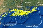
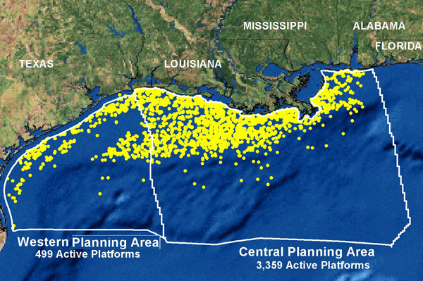
the answer is partly yes and partly no. Most of those active platforms are in the shelf region, where the water is shallower and the sea bed is also thicker. I'm more concerned about the smaller number of wells that are either being drilled a little further out where the converse holds true.
Deeper water and in many cases a thinner sea floor concerns me as sea floor is often more brittle than land-based -- ummm -- land. (Sorry. Getting tired again.) But you get what I mean, I expect.
On the other hand, there is the fact that (as they say), that map shows active wells and doesn't give us the full picture of the wells that have already gone dry and been capped. I don't have the reference to hand but it's a huge number, I believe.
I would be most interested to see figures for how many tons/barrels/any standard unit of liquid hydrocarbons have been removed from the GOM region over the years, along with the number of cu ft/m of gas. Would like to know how it all works out in terms of net volume of virtually incompressible liquids and the assumed pre-release volume of naturally-pressurized gas at an averaged pressure of (X) psi. I expect it would work out to a pretty big number. Has to be in the millions of tons at least, surely.
If anyone knows of a scientific survey or study that has such figures I'd be glad for a link to it.
Put it this way: if we (the non-specific we) remove millions of tons of liquids from rock strata under a sea bed which has massive pressure from deep water sitting on top of it, is it unreasonable to assume sooner or later, something will have to give to bring things back into balance again? After all, that's the thinking of Dr Dutton re the quake in Texas, so if it's relevant to removing "oil and water" via drilling on dry land, is it not equally relevant in the scenario of land that's sitting under deep water?
I think it is.
Mike
Hi J&C,
the answer is partly yes and partly no. Most of those active platforms are in the shelf region, where the water is shallower and the sea bed is also thicker. I'm more concerned about the smaller number of wells that are either being drilled a little further out where the converse holds true.
Deeper water and in many cases a thinner sea floor concerns me as sea floor is often more brittle than land-based -- ummm -- land. (Sorry. Getting tired again.) But you get what I mean, I expect.
On the other hand, there is the fact that (as they say), that map shows active wells and doesn't give us the full picture of the wells that have already gone dry and been capped. I don't have the reference to hand but it's a huge number, I believe.
I would be most interested to see figures for how many tons/barrels/any standard unit of liquid hydrocarbons have been removed from the GOM region over the years, along with the number of cu ft/m of gas. Would like to know how it all works out in terms of net volume of virtually incompressible liquids and the assumed pre-release volume of naturally-pressurized gas at an averaged pressure of (X) psi. I expect it would work out to a pretty big number. Has to be in the millions of tons at least, surely.
If anyone knows of a scientific survey or study that has such figures I'd be glad for a link to it.
Put it this way: if we (the non-specific we) remove millions of tons of liquids from rock strata under a sea bed which has massive pressure from deep water sitting on top of it, is it unreasonable to assume sooner or later, something will have to give to bring things back into balance again? After all, that's the thinking of Dr Dutton re the quake in Texas, so if it's relevant to removing "oil and water" via drilling on dry land, is it not equally relevant in the scenario of land that's sitting under deep water?
I think it is.
Mike
edit on 26/10/11 by JustMike because: minor syntax korekshun .
If point A is around Trinidad, Colorado. I don't know. Wherever that 5.8 hit. abouts
If point B is Mineral, Virignia.
What would the arc it makes looks like?
Would it produce a circle or an elipse?
Don't ask me.
If I think about it too long it starts to look like a submarine. A yellow one.
Edit. You idiot. The arc should try and follow the activity near Arkansas. Sorry. There's just many things that are bugging me. I know there's something to the band that runs from West to East from Colorado to Virgina.
It's Mama's fault cause she called the line of quakes the Bible Belt.
I may as well try to salvage this post- here's the last two quakes. There were three. But the USGS is prejudiced against the small ones. They are lonely. And misunderstood. I love them. They should start a band.
MAP 2.2 2011/10/26 17:06:09 35.354 -92.272 5.4 6 km ( 4 mi) WSW of Quitman, AR
MAP 2.2 2011/10/26 16:07:54 35.356 -92.275 6.1 6 km ( 4 mi) WSW of Quitman, AR
What the hell is that near the 2.7M quake? I thought it was a frack pad. But there's no pond. Pipeline Pad?
Injection? Is it the one outside Guy they've already closed?
When you think about drilling and what's it gonna do, you need to consider the crust. It's pretty much brittle and new. It's sediments. Sands. Full of gas and goo. Not exactly stable.
edit on 26-10-2011 by Robin Marks because: (no reason given)
new topics
-
Bobiverse
Fantasy & Science Fiction: 2 hours ago -
Florida man's trip overseas ends in shock over $143,000 T-Mobile phone bill
Social Issues and Civil Unrest: 2 hours ago -
Former Labour minister Frank Field dies aged 81
People: 4 hours ago -
SETI chief says US has no evidence for alien technology. 'And we never have'
Aliens and UFOs: 6 hours ago -
This is our Story
General Entertainment: 8 hours ago -
President BIDEN Vows to Make Americans Pay More Federal Taxes in 2025 - Political Suicide.
2024 Elections: 11 hours ago
top topics
-
President BIDEN Vows to Make Americans Pay More Federal Taxes in 2025 - Political Suicide.
2024 Elections: 11 hours ago, 14 flags -
Should Biden Replace Harris With AOC On the 2024 Democrat Ticket?
2024 Elections: 17 hours ago, 6 flags -
One Flame Throwing Robot Dog for Christmas Please!
Weaponry: 15 hours ago, 6 flags -
Florida man's trip overseas ends in shock over $143,000 T-Mobile phone bill
Social Issues and Civil Unrest: 2 hours ago, 5 flags -
Don't take advantage of people just because it seems easy it will backfire
Rant: 16 hours ago, 4 flags -
Ditching physical money
History: 15 hours ago, 4 flags -
SETI chief says US has no evidence for alien technology. 'And we never have'
Aliens and UFOs: 6 hours ago, 4 flags -
Former Labour minister Frank Field dies aged 81
People: 4 hours ago, 4 flags -
Ode to Artemis
General Chit Chat: 12 hours ago, 3 flags -
This is our Story
General Entertainment: 8 hours ago, 3 flags
active topics
-
President BIDEN Vows to Make Americans Pay More Federal Taxes in 2025 - Political Suicide.
2024 Elections • 55 • : CriticalStinker -
VirginOfGrand says hello
Introductions • 3 • : F2d5thCavv2 -
"We're All Hamas" Heard at Columbia University Protests
Social Issues and Civil Unrest • 272 • : WeMustCare -
The Acronym Game .. Pt.3
General Chit Chat • 7743 • : F2d5thCavv2 -
SETI chief says US has no evidence for alien technology. 'And we never have'
Aliens and UFOs • 25 • : Cvastar -
Suspended Nigerian Poverty Minister had $24M in her Bank Accounts
Political Issues • 11 • : malamarabi -
Should Biden Replace Harris With AOC On the 2024 Democrat Ticket?
2024 Elections • 47 • : Cvastar -
Florida man's trip overseas ends in shock over $143,000 T-Mobile phone bill
Social Issues and Civil Unrest • 2 • : mysterioustranger -
Post A Funny (T&C Friendly) Pic Part IV: The LOL awakens!
General Chit Chat • 7133 • : underpass61 -
Thousands Of Young Ukrainian Men Trying To Flee The Country To Avoid Conscription And The War
Other Current Events • 128 • : twistedpuppy