It looks like you're using an Ad Blocker.
Please white-list or disable AboveTopSecret.com in your ad-blocking tool.
Thank you.
Some features of ATS will be disabled while you continue to use an ad-blocker.

What's this off the coast of Ventura California?
page: 3share:
reply to post by schuyler
I thought I notice white caps too, but it's the shadow that's got me puzzled. I've seen images where there is a cloud shadow but no cloud and that's from updated images of a clear day from the neighboring section, but I don't think that's what's happening here.
If it is a decomissioned oil rig, it it possibe that the grating is open enough to allow the sea to show through without casting a shadow over the area?
By now, I would have hoped that someone who lives on the coast would have recognized it and cleared this up for us. But I'm glad to see that others think it's interesting too. So until someone officially burst my bubble, I claim this to be a UFO, Unidentifed (possibly) Floating Object
reply to post by paraclete1
Sorry to burst your bubble, this could easily be a naturally formed Bubble Ring.
Sorry to burst your bubble, this could easily be a naturally formed Bubble Ring.
A bubble ring is an underwater ring vortex where an air bubble occupies the core of the vortex, forming a ring shape. The ring of air as well as the nearby water spins toroidially as it travels through the water, much like a flexible bracelet might spin when it is rolled off a person's arm. Some scuba divers can create bubble rings by blowing air out of their mouth in a particular manner. Long bubble rings also can form spontaneously in turbulent water such as in heavy surf. Bubble rings and smoke rings are both forms of vortex rings, and are sometimes studied in the field of fluid dynamics. Dolphins and humpback whales have also been seen to create bubble rings.
Its the same as a lenticular cloud, but underwater!!!! Or perhaps a whale farted causing a massive carbon dioxide bubble which held still while the
satellite snapped its picture!
You cant fool the skeptics they always have a theory down their shorts
You cant fool the skeptics they always have a theory down their shorts
This anomaly has some strangeness to it, this section of ocean and waves and beach area is a CUT AND PASTE repeated area, both repeated areas have the
bubble anomaly, the same wave areas etc.
The repeated section is just north of the area in question:
It could be a bubble, an image artifact, especially since it is shown to be an area that has been used in an image manipulation...Why was this area duplicated? Was there missing data in this duplicated area, or is it an area that needs to be hidden?
Nothing to see here, some 13 year old hacked google and is just messing with us.
[edit on 22-9-2007 by wildone106]
Originally posted by greatlakes
This anomaly has some strangeness to it, this section of ocean and waves and beach area is a CUT AND PASTE repeated area, both repeated areas have the bubble anomaly, the same wave areas etc.
The repeated section is just north of the area in question:
It could be a bubble, an image artifact, especially since it is shown to be an area that has been used in an image manipulation...Why was this area duplicated? Was there missing data in this duplicated area, or is it an area that needs to be hidden?
[edit on 22-9-2007 by wildone106]
Originally posted by schuyler
it looks to be about 75 feet in diameter according to the legend at the bottom left of Goggle Earth.
I don't know that it's terribly important, but I've carefully measured it, and it's about 12 meters in diameter, or about 40 feet. My original guess of an oil platform was based on the closeup picture posted. After downloading Google Earth and seeing the proximity to the shore, obviously that's not what it is.
I wonder if there is there anyone reading this living in Oxnard or Ventura? Tomorrow is forecast to be sunny (it's raining right now). Go to McGrath Beach, and standing between the access path and the sewage outlet, look straight out. It's about 800 feet from the shoreline. I should think if there's anything there rising above sea level, it should be visible. Refer to the location using Google maps (look right between Ventura and Oxnard, just off the southern tip of McGrath Lake). Low tide is around 1 p.m., so time your arrival for sometime in the early afternoon. Don't forget binoculars and camera.
Please post if you're willing to take on this project for us and see what's what. If no one volunteers, I'll do it.
Ugh! I wish I paid more attention beforehand. The object further up the coast is identical. This is a photographic artifact of some kind. The trip is
off.
Originally posted by yuefo
Ugh! I wish I paid more attention beforehand. The object further up the coast is identical. This is a photographic artifact of some kind. The trip is off.
Given that the images are probably not recent, you most likely would have been wasting your time anyway.
The images from where I live, though copyrighted as 2007, date back to May/Jun 2004. I can tell this from the the houses built/not built in my neighbourhood and the aircraft that are shown at the nearby airbase. They would only be there during Ex Maple Flag, which occurs in May/Jun.
Originally posted by yuefo
Originally posted by schuyler
it looks to be about 75 feet in diameter according to the legend at the bottom left of Goggle Earth.
I don't know that it's terribly important, but I've carefully measured it, and it's about 12 meters in diameter, or about 40 feet. My original guess of an oil platform was based on the closeup picture posted. After downloading Google Earth and seeing the proximity to the shore, obviously that's not what it is.
I wonder if there is there anyone reading this living in Oxnard or Ventura? Tomorrow is forecast to be sunny (it's raining right now). Go to McGrath Beach, and standing between the access path and the sewage outlet, look straight out. It's about 800 feet from the shoreline. I should think if there's anything there rising above sea level, it should be visible. Refer to the location using Google maps (look right between Ventura and Oxnard, just off the southern tip of McGrath Lake). Low tide is around 1 p.m., so time your arrival for sometime in the early afternoon. Don't forget binoculars and camera.
Please post if you're willing to take on this project for us and see what's what. If no one volunteers, I'll do it.
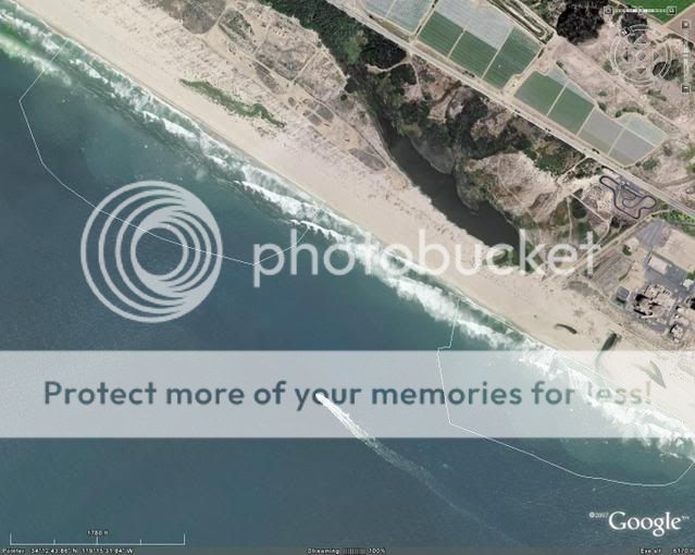
I believe what your're talking about is the water outlet for Mandalay Generating station in Ventura, California.
I grew up there and did a lot of sailing off the coast.
As well as worked for Southern California Edison Company and dispatched the electrical end of the plant.
A few miles down the beach is Ormond Beach generating station.
It has a similar water outlet.
We used to anchor the sailboat near the Ormond Beach water outlet and fish.
Good fishing because some of the fish that go into the intake canal are drawn into the plant water intake where they desalinize it and use the pure water in the plant boilers.
(True for both plants.)
The chopped up fish parts attract a lot of fish to the outlet.
On calm days the ring of water welling up is easy to find.
The ring proper is 6' - 12' or so in diameter.
Easy to see from the generating plant's catwalks as well.
At Mandalay you can be 100' above ground level standing on expanded metal catwalks - which means you can see straight down through the catwalk.
A little unnerving till you get used to it.
As noted, the outlets are about 800' - 1320' off the beach.
The middle green part is another water outlet and not a sewage outlet.
An interesting hobby my pal's wife used to take part in was looking for broken glass bottle pieces that had been washed back and forth over the sand in that area.
Where the outlet water meets the sea is about the best area to look.
Low tide being the best time.
The sharp corners of the glass wear dull and the glass surface wears dull.
Get enough of the 'sand-blasted' glass pieces, put them in a clear wine bottle, fill with water and seal.
Makes for a very beautiful display to set on the table.
You'll find many colors of glass and the colors come through quite well when immersed in water.
Or simply put the glass pieces in a shallow bowl and leave dry.
Other fun stuff, give your kids a strong magnet and have them sweep it through the sand.
They'll pick up lots of black sand/iron stuff and most kids are fascinated by it.
Originally posted by Desert Dawg
On calm days the ring of water welling up is easy to find.
The ring proper is 6' - 12' or so in diameter.
Thanks for posting Dawg. You seem to know what you're talking about, but I'm confused on a point--if the ring is what you say, how do you account for the identical object further up the shore? By identical, I mean that the surface features on it and in the surrounding water are exactly the same. On the basis of that, I concluded it was a photographic glitch of some sort.
Originally posted by yuefo
Originally posted by Desert Dawg
On calm days the ring of water welling up is easy to find.
The ring proper is 6' - 12' or so in diameter.
... By identical, I mean that the surface features on it and in the surrounding water are exactly the same. On the basis of that, I concluded it was a photographic glitch of some sort....
IMHO, are the same object repeated (i.e. some kind of copy-paste);
we could explane the similarities between the two objects, but not the ones between the surroundings.

[edit on 22/9/2007 by internos]
Originally posted by internos
IMHO, are the same object repeated (i.e. some kind of copy-paste);
we could explane the similarities between the two objects, but not the ones between the surroundings.
And that, to me, is odder than the ring itself. If you look at the images posted by Greatlakes, while the area surrounding the rings are identical, the waves breaking on the shoreline are not. Moreover, the speedboat reveals that further out, the images aren't repeated. What could account for this small, localized repetition? Unless Google utilizes this effect intentionally, it's a coincidence that the repeated image meshes so well in two areas, yet retains the unique characteristics of the two shorelines. Very puzzling.
i just hapened to notice this while investigating a little further with google earth
this is just a little NNE of where the original two blips are,also pretty close to the coastline

it's a screenshot i took of google earth so the coordinates and altitude should be on there too
if you look carefully,you'll notice an almost perfectly square shaped repeating pattern

here's the same picture with the repeating pattern outlined
you'll notice that the blips on the left side of the square ar tilted sligtly to the left and pose in a near 90° angle as opposed to the blips in the right
now the way i see it,there's three options:
1.the boys and girls at google got lazy and did the copy paste thingy in stead of inserting the real pictures.
2.somthing's going on over there.
3.i should realy get some sleep,or maybe lay of the coffee...
which one it realy is is what i'd like to know...
this is just a little NNE of where the original two blips are,also pretty close to the coastline
it's a screenshot i took of google earth so the coordinates and altitude should be on there too
if you look carefully,you'll notice an almost perfectly square shaped repeating pattern
here's the same picture with the repeating pattern outlined
you'll notice that the blips on the left side of the square ar tilted sligtly to the left and pose in a near 90° angle as opposed to the blips in the right
now the way i see it,there's three options:
1.the boys and girls at google got lazy and did the copy paste thingy in stead of inserting the real pictures.
2.somthing's going on over there.
3.i should realy get some sleep,or maybe lay of the coffee...
which one it realy is is what i'd like to know...
I gathered 3 maps:
but i fear it's useless, because are based on pics taken in three different years:
the yahoo one is the oldest, the google one is the most recent.

but i fear it's useless, because are based on pics taken in three different years:
the yahoo one is the oldest, the google one is the most recent.
Hi interesting objects for sure. I found something on Google earth as well. It is most likely an oil platform but just for the sake of other opinions
you can check it out at 57'55'45.64 N 6'40'48.41 W I am sorry I have no clue of how to do this properly either as far as providing a picture. I
hope some good Samaritan can help me out there as well . thanks in advance. M,O
May or may not be relevant, but if you look a little further down, not quite a mile south of the lower circle, there looks to be a small plane in the
ocean. I say in the ocean, as opposed to flying, because for one the only shadow I can see is directly under the nose, like it is floating on top of
the water. Two, it appears that the boat just left from there. If you trace the wake back, it originates at the plane. I know that some small planes
are equipped to take off and land in the water, but I didn't think they were generally used in the ocean being that it is much more choppier than a
lake. Plus this plane looks bigger than that, and the tail looks like it might be submerged a little. But like I said, it may or may not have anything
to do with the circular objects, but interesting either way.
Good find Evilod. I'll be danged if that doesn't look like a downed plane in the water. What an odd thread this has turned out to be!
We actually have two questions, what the object is, and why did google do a duplication. Or why did sat company do it.
The duplication is not an accident, it matches to well. I suggest somebody should contact google, find the satalite source and contact them. It would be interesting to hear what they say caused in.
The duplication is not an accident, it matches to well. I suggest somebody should contact google, find the satalite source and contact them. It would be interesting to hear what they say caused in.
Originally posted by ModisOperandi
Hi interesting objects for sure. I found something on Google earth as well. It is most likely an oil platform but just for the sake of other opinions you can check it out at 57'55'45.64 N 6'40'48.41 W I am sorry I have no clue of how to do this properly either as far as providing a picture. I hope some good Samaritan can help me out there as well . thanks in advance. M,O
Here:

bit strange shape though.
Oh and to evilod, well spotted.
reply to post by apex
That photo looks to me like a giant piece of Honeycomb cereal..
In all seriousness, I do find it strange that there would be apparent editing in the google images. Perhaps, as said earlier in the thread, because it is a military area, something has been edited out of the photos. Perhaps some sort of military platform or large ship that needed to be removed from the photo for the sake of confidentiality, just a thought.
Strange indeed..
new topics
-
A Warning to America: 25 Ways the US is Being Destroyed
New World Order: 1 hours ago -
America's Greatest Ally
General Chit Chat: 2 hours ago -
President BIDEN's FBI Raided Donald Trump's Florida Home for OBAMA-NORTH KOREA Documents.
Political Conspiracies: 7 hours ago -
Maestro Benedetto
Literature: 8 hours ago -
Is AI Better Than the Hollywood Elite?
Movies: 8 hours ago
top topics
-
President BIDEN's FBI Raided Donald Trump's Florida Home for OBAMA-NORTH KOREA Documents.
Political Conspiracies: 7 hours ago, 27 flags -
Weinstein's conviction overturned
Mainstream News: 16 hours ago, 8 flags -
Gaza Terrorists Attack US Humanitarian Pier During Construction
Middle East Issues: 13 hours ago, 8 flags -
Massachusetts Drag Queen Leads Young Kids in Free Palestine Chant
Social Issues and Civil Unrest: 15 hours ago, 7 flags -
Las Vegas UFO Spotting Teen Traumatized by Demon Creature in Backyard
Aliens and UFOs: 12 hours ago, 6 flags -
Meadows, Giuliani Among 11 Indicted in Arizona in Latest 2020 Election Subversion Case
Mainstream News: 15 hours ago, 5 flags -
2024 Pigeon Forge Rod Run - On the Strip (Video made for you)
Automotive Discussion: 13 hours ago, 4 flags -
Is AI Better Than the Hollywood Elite?
Movies: 8 hours ago, 3 flags -
A Warning to America: 25 Ways the US is Being Destroyed
New World Order: 1 hours ago, 3 flags -
Maestro Benedetto
Literature: 8 hours ago, 1 flags
active topics
-
HORRIBLE !! Russian Soldier Drinking Own Urine To Survive In Battle
World War Three • 50 • : F2d5thCavv2 -
Russia Ukraine Update Thread - part 3
World War Three • 5732 • : F2d5thCavv2 -
The Acronym Game .. Pt.3
General Chit Chat • 7751 • : F2d5thCavv2 -
Salvador Dali's Moustaches
People • 28 • : zosimov -
Is AI Better Than the Hollywood Elite?
Movies • 17 • : ThePsycheaux -
The best Rice dish i've ever tasted... Kimchi Rice
Food and Cooking • 26 • : lamhaocc -
A Warning to America: 25 Ways the US is Being Destroyed
New World Order • 1 • : 727Sky -
Massachusetts Drag Queen Leads Young Kids in Free Palestine Chant
Social Issues and Civil Unrest • 15 • : tarantulabite1 -
America's Greatest Ally
General Chit Chat • 1 • : BingoMcGoof -
How ageing is" immune deficiency"
Medical Issues & Conspiracies • 35 • : annonentity