It looks like you're using an Ad Blocker.
Please white-list or disable AboveTopSecret.com in your ad-blocking tool.
Thank you.
Some features of ATS will be disabled while you continue to use an ad-blocker.

Is this Atlantis?
page: 3share:
reply to post by schrodingers dog
And all of the photos they showed there did in fact look like sonar tracks...
However, this one doesn't look like any other sonar tracks...
Sorry I'm still not seeing it...
How can you say that the first image is anything like the second?
If those are sonar tracks, I want to know what sonar tech was dragging them in that pattern in that area of the ocean and why...
And all of the photos they showed there did in fact look like sonar tracks...
However, this one doesn't look like any other sonar tracks...
Sorry I'm still not seeing it...
How can you say that the first image is anything like the second?

If those are sonar tracks, I want to know what sonar tech was dragging them in that pattern in that area of the ocean and why...
reply to post by HunkaHunka
As it explains on the page there many different types of sonar tracks.
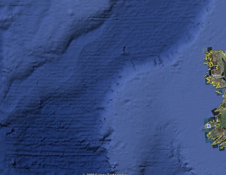
Here's another example I just found by browsing the ocean floor west of Ireland on GE:
If you look at the tracks at the bottom of the picture they are quite similar to the ones in the OP.
I don't want to get into a thing here as I'm not an expert on this by any means, but surely this seems a more plausible explanation than believing that not only was Atlantis bigger than LA, but it was also gridded the same way.
[edit on 19 Feb 2009 by schrodingers dog]
As it explains on the page there many different types of sonar tracks.
Here's another example I just found by browsing the ocean floor west of Ireland on GE:
If you look at the tracks at the bottom of the picture they are quite similar to the ones in the OP.
I don't want to get into a thing here as I'm not an expert on this by any means, but surely this seems a more plausible explanation than believing that not only was Atlantis bigger than LA, but it was also gridded the same way.
[edit on 19 Feb 2009 by schrodingers dog]

reply to post by HunkaHunka
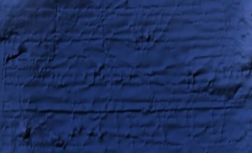
Yeah, I'm not completely sold, yet. I don't think the first image posted bears resemblance to the second more symmetrical image. I think the key to this mystery is in lines from this image:
img8.imageshack.us...[/img]
Lining up with this image:
img18.imageshack.us...[/img]
A user named Hill posted this image on the keyhole site. Apparently, the UK generated these tracks to if the ocean basins were a good place to dump nuclear waste. Not all of the tracks show up in Google Earth's Bathymetry. The one's that did show created the symmetrical square shape which is in the second image. The latitude and longitude in the first image also lines up to where the square shape off of Africa is located.
Ok, maybe now I'm sold.
*edited because I can seem to get my images to be embedded into my post
[edit on 19-2-2009 by frailty]
[edit on 19-2-2009 by frailty]
reply to post by frailty
So, what's not being said here, is if this is the case, where did all the other parts of the tracks disappear to?
I can see how one can suggest the other, However i don't see what the answer would be to where the others are.
But yes, I can see how it could be a very odd sonar track... but I still think it should be checked out.
The one thing I haven't seen yet is what could explain the right angles on the corners of this thing.
I haven't seen any examples of sonar tracks making right angles on the ocean floor
[edit on 19-2-2009 by HunkaHunka]
1981 World Ocean Floor Map
This beautiful physical world map, first published in December 1981, captures the oceans and land of the Earth as only National Geographic can. Stunning relief shading accentuates the drama of the Earths underwater world. See the ocean floor, mountain ranges, river valleys, deserts, and continental shelves, in amazing detail and beauty. The 1981 World Ocean Floor map features: Dramatic ocean floor topography, showing major underwater rifts, trenches, and "mountains;" physical features for all seven continents; mountain ranges with beautiful relief shading; major vegetation zones to easily visualize everything from the densest forests to the most barren deserts.
shop.nationalgeographic.com...
reply to post by zorgon
Heh... that was pretty funny. Looking at the ocean floor through early 80's resolution.
Thanks for the laugh!
Heh... that was pretty funny. Looking at the ocean floor through early 80's resolution.
Thanks for the laugh!
Originally posted by HunkaHunka
reply to post by frailty
So, what's not being said here, is if this is the case, where did all the other parts of the tracks disappear to?
I can see how one can suggest the other, However i don't see what the answer would be to where the others are.
But yes, I can see how it could be a very odd sonar track... but I still think it should be checked out.
The one thing I haven't seen yet is what could explain the right angles on the corners of this thing.
I haven't seen any examples of sonar tracks making right angles on the ocean floor
[edit on 19-2-2009 by HunkaHunka]
Yeah dude, if you look closely at the supposed Atlantis, you're right about the right-angles. Not only that, but look even more closely at the lines. Some of them are not perfectly linear. Like they were drawn by hand, so to speak. I thought sonar tracks were perfectly linear.
reply to post by HunkaHunka
Honestly, I don't know what else to say on this other than the explanation I provided is but one alternative explanation to the claim that Atlantis has been discovered.
I'm actually not trying to "debunk" anything, imo the size and shape of the artifact pretty much achieves that on its own.
It would be interesting to find out the correct answer one way or the other, the probability that that answer will satisfy the Atlantis seekers however, is very slim.
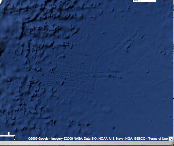
I've been interested in the legend of Atlantis for a long time. This formation does not look like a natural geological formation, but who knows. I
agree with the archaeologist that said it deserves a closer look.
Here is a map of the area:
maps.google.com... ...
...That's quite large - around 100 miles wide, by Google's scale. There are many formations in its vicinity as well.
Also, I was scanning around and found this:
maps.google.com... ...
...whatever it is it's larger than Britain itself. I don't know what to make of this.
reply to post by schrodingers dog
I agree with what you say about "Atlantis Seekers".
However, "Atlantis Agnostics", such as myself only seek decent debunking of these "finds". I agree there are many suggestions for what this might be.
I also feel that we should find out, beyond the shadow of a doubt, what this is.
Could it be sonar tracks? Sure... however I have yet to see sonar tracks which look like this. For example, right angles?
Could it be marks put on a map by the map maker? Sure, but I highly doubt these are the types of a marks a cartographer would use, especially when valid ones are typically letters.
Could it be Atlantis? If you mean a city spoken of in ancient literature which was huge and was also destroyed by volcanoes and flooding, but has also yet to be found yet. Sure... I don't think this is a far fetched thing. Hellenic cities described by Homer were long thought to be simply fables until larger than expected cities were in fact found.
I think all three of these possibilities are equally plausible.
reply to post by HunkaHunka
Remember the GE picture I posted earlier from sonar scans off the coast of Ireland?
Here's a close up of one section of it:
As you can see there are lines intersecting at many different angles including right ones.
And though anything is possible, to say that all explanations including this being Atlantis are equally plausible is imo erroneous.

reply to post by HunkaHunka
Gleaning from what I read in the UK document. They specifically sonar tracked this area with all the different markings and patterns (found in my first image of my last post) to test the conditions of the area to see if it contained a suitable environment for what they wanted it for, which in this case was to dump nuclear waste. Some the things that they tested for were geochemistry, sedimentary and fault lines around this location. So basically, the reason that these marking are different from regular sonar markings is because they are not regular sonar markings. They were done for a specific purpose.
Apparently, the reason that not of all of the markings from my first image posted above are seen on Google Earth is because some of the markings were done to be read by sonar at different frequencies. So, Google Earth only picked up on the marks that it could "see" at the frequency that their sonar equipment was working at and not the rest.
reply to post by schrodingers dog
Yes there are intersections forming right angles, however on the artifact in question there are right angles without intersections.
Why do you believe that it is not plausible to find atlantis?
We found Troy... and many thought that was completely legend as well.
Why not Atlantis?
Yes there are intersections forming right angles, however on the artifact in question there are right angles without intersections.
Why do you believe that it is not plausible to find atlantis?
We found Troy... and many thought that was completely legend as well.
Why not Atlantis?
Originally posted by HunkaHunka
reply to post by schrodingers dog
Why do you believe that it is not plausible to find atlantis?
That is not the case at all, though since I am of Greek origin I want to be there.
Seriously, it would be great if Atlantis was found anywhere. But you called yourself a skeptic and as a skeptic there are numerous steps between a few lines on a digital map and the declaration of the finding of Atlantis.
Don't you think?
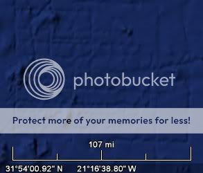
This is very interesting, however the scale of the grid at 108 miles kind of defeats it as being an ancient city, as the scale alone is irrational to
think a city of that scale could exist at that time.
Also, it's to perfectly rectangular... sonar lines does make the explanation more believable... after all... this is digital imagery, not the real thing we are seeing... all sorts of artifacts man made can exist.
A very cool google artifact, but not Atlantis, at least... not at that scale.
Also, it's to perfectly rectangular... sonar lines does make the explanation more believable... after all... this is digital imagery, not the real thing we are seeing... all sorts of artifacts man made can exist.
A very cool google artifact, but not Atlantis, at least... not at that scale.
new topics
-
America's Greatest Ally
General Chit Chat: 10 minutes ago -
President BIDEN's FBI Raided Donald Trump's Florida Home for OBAMA-NORTH KOREA Documents.
Political Conspiracies: 5 hours ago -
Maestro Benedetto
Literature: 6 hours ago -
Is AI Better Than the Hollywood Elite?
Movies: 6 hours ago -
Las Vegas UFO Spotting Teen Traumatized by Demon Creature in Backyard
Aliens and UFOs: 10 hours ago -
2024 Pigeon Forge Rod Run - On the Strip (Video made for you)
Automotive Discussion: 11 hours ago -
Gaza Terrorists Attack US Humanitarian Pier During Construction
Middle East Issues: 11 hours ago
top topics
-
President BIDEN's FBI Raided Donald Trump's Florida Home for OBAMA-NORTH KOREA Documents.
Political Conspiracies: 5 hours ago, 26 flags -
Krystalnacht on today's most elite Universities?
Social Issues and Civil Unrest: 16 hours ago, 9 flags -
Gaza Terrorists Attack US Humanitarian Pier During Construction
Middle East Issues: 11 hours ago, 8 flags -
Supreme Court Oral Arguments 4.25.2024 - Are PRESIDENTS IMMUNE From Later Being Prosecuted.
Above Politics: 16 hours ago, 8 flags -
Weinstein's conviction overturned
Mainstream News: 14 hours ago, 8 flags -
Massachusetts Drag Queen Leads Young Kids in Free Palestine Chant
Social Issues and Civil Unrest: 13 hours ago, 7 flags -
Las Vegas UFO Spotting Teen Traumatized by Demon Creature in Backyard
Aliens and UFOs: 10 hours ago, 6 flags -
Meadows, Giuliani Among 11 Indicted in Arizona in Latest 2020 Election Subversion Case
Mainstream News: 13 hours ago, 5 flags -
2024 Pigeon Forge Rod Run - On the Strip (Video made for you)
Automotive Discussion: 11 hours ago, 4 flags -
Is AI Better Than the Hollywood Elite?
Movies: 6 hours ago, 3 flags
active topics
-
Hate makes for strange bedfellows
US Political Madness • 48 • : Terpene -
Is AI Better Than the Hollywood Elite?
Movies • 15 • : 5thHead -
America's Greatest Ally
General Chit Chat • 0 • : 19Bones79 -
President BIDEN's FBI Raided Donald Trump's Florida Home for OBAMA-NORTH KOREA Documents.
Political Conspiracies • 17 • : BingoMcGoof -
Gaza Terrorists Attack US Humanitarian Pier During Construction
Middle East Issues • 29 • : 19Bones79 -
Supreme Court Oral Arguments 4.25.2024 - Are PRESIDENTS IMMUNE From Later Being Prosecuted.
Above Politics • 90 • : Lumenari -
Las Vegas UFO Spotting Teen Traumatized by Demon Creature in Backyard
Aliens and UFOs • 12 • : KrustyKrab -
SHORT STORY WRITERS CONTEST -- April 2024 -- TIME -- TIME2024
Short Stories • 23 • : DontTreadOnMe -
Truth Social goes public, be careful not to lose your money
Mainstream News • 130 • : Astyanax -
-@TH3WH17ERABB17- -Q- ---TIME TO SHOW THE WORLD--- -Part- --44--
Dissecting Disinformation • 689 • : daskakik