It looks like you're using an Ad Blocker.
Please white-list or disable AboveTopSecret.com in your ad-blocking tool.
Thank you.
Some features of ATS will be disabled while you continue to use an ad-blocker.

Uncensored NASA Moon Images!!
page: 41share:
I simply mean that most links do not have an image attached. Just a little x. No longer available?
Yes, I see what you mean. If I am careful, I can force my eyes to see the image correctly.
Object from AS15-M-1720_LRG rotated 90 degrees. (256 colors)

Image from before rotation. This image really threw me. I could have sworn the lunar dust was scooped out instead of mounded. Now I am satisfied there is no 'object' there, just lots of dust. (256 colors)
Yes, I see what you mean. If I am careful, I can force my eyes to see the image correctly.
Object from AS15-M-1720_LRG rotated 90 degrees. (256 colors)
Image from before rotation. This image really threw me. I could have sworn the lunar dust was scooped out instead of mounded. Now I am satisfied there is no 'object' there, just lots of dust. (256 colors)
reply to post by SPreston
Could you give me an example of one of those images?
All the images I tried appeared correctly, although I usually do not see the images, I use Free Download Manager to download them.
Could you give me an example of one of those images?
All the images I tried appeared correctly, although I usually do not see the images, I use Free Download Manager to download them.
Originally posted by Willbert
Originally posted by thrashee
reply to post by ArMaP
That's not the track picture that was posted originally.
I'm looking for the originals of these:
Actually... ArMaP gave you the right file. The location is near the bottom right corner of that photo...
I found a lot of other "tracks" in that file pointing towards that crater.
Anyone know the name of that crater?
At first I thought "scratches". Still do... but find it interesting that the seem to be pointing to the crater.
lo3-72-h2c
PP Latitude -0.8
PP Longitude 24.3
Altitude (km) 49.9
I think the crater is La Caille which you can locate with this:
Apollo Mission 16 Lunar Photography Index Map
Originally posted by ArMaP
reply to post by SPreston
Could you give me an example of one of those images?
All the images I tried appeared correctly, although I usually do not see the images, I use Free Download Manager to download them.
Now they are opening just fine. I tried the exact same large images I tried before. They must have been in the middle of some down time or something.
Index of /data/metric/AS15/png
Originally posted by SPreston
Originally posted by Willbert
Actually... ArMaP gave you the right file. The location is near the bottom right corner of that photo...
I found a lot of other "tracks" in that file pointing towards that crater.
Anyone know the name of that crater?
At first I thought "scratches". Still do... but find it interesting that the seem to be pointing to the crater.
lo3-72-h2c
PP Latitude -0.8
PP Longitude 24.3
Altitude (km) 49.9
I think the crater is La Caille which you can locate with this:
Apollo Mission 16 Lunar Photography Index Map
La Caille
Diameter: 67 km
Lat: -23.8º Long: 1.1º
Origin of Name: Nicholas-Louis De; French astronomer (1713-1762).
With this mapper, you can search for a certain crater and other things, zoom in and out, mark lunar details and click on the pins for info, and other features. Resolution is not good.
Clementine Lunar Map 2.0
The 'tracks' images were taken and are visible from 49.9 km (31 miles) altitude. So they must be parallel roads or pipelines or trenches or aqueducts or something large enougn to be seen from 31 miles up. Or they are nothing but accidental marks on the image.
Assuming they are continuous construction, then the 'tracks' are partially covered in some areas and totally hidden in other areas by lunar dust. This 'track' seems to go down into the crater a short way. The 'tracks' are not perfectly straight nor perfecly spaced apart and to the left of this image, one set spreads apart.
reply to post by SPreston
You have the coordinates mixed up.
The Lunar Orbiter photo is from 0.8º S, 24.3º E, crater "La Caille" is 23.8º S, 1.1º E.
As I said before, I think that crater is Moltke, located at 0.6º S, 24.2º E.
[edit on 29/8/2008 by ArMaP]
You have the coordinates mixed up.
The Lunar Orbiter photo is from 0.8º S, 24.3º E, crater "La Caille" is 23.8º S, 1.1º E.
As I said before, I think that crater is Moltke, located at 0.6º S, 24.2º E.
[edit on 29/8/2008 by ArMaP]
Originally posted by ArMaP
reply to post by SPreston
You have the coordinates mixed up.
The Lunar Orbiter photo is from 0.8º S, 24.3º E, crater "La Caille" is 23.8º S, 1.1º E.
As I said before, I think that crater is Moltke, located at 0.6º S, 24.2º E.
Yes, my error. The Clementine Lunar Map agrees with you.
However that crater looks far bigger than 6 km in diameter don't you think? Could that be the Rimae Hypatia I next to the tracks?
Lunar Orbiter photo Lat: -0.8º (S) Long: 24.3º (E)
La Caille
Diameter: 67 km
Lat: -23.8º (S)
Long: 1.1º (E)
Moltke
Diameter: 6 km
Lat: -0.6º (S)
Long: 24.2º (E)
Rimae Hypatia
Diameter: 206 km
Lat: -0.4º (S)
Long: 22.4º (E)
Origin of Name: Named from nearby crater.
Moltke and Rima Hypatia AS10-29-4324HR
[edit on 8/29/08 by SPreston]
Nearby was the alleged Apollo 11 landing site on July 20, 1969.
Lunar Orbiter photo Lat: -0.8º (S) Long: 24.3º (E)
[edit on 8/29/08 by SPreston]
Statio Tranquillitatis
Diameter: 0 km
Lat: 0.8º (N) Long: 23.5º (E)
Origin of Name: "Tranquility Base, Apollo 11 landing site."
Lunar Orbiter photo Lat: -0.8º (S) Long: 24.3º (E)
Moltke
Diameter: 6 km
Lat: -0.6º (S)
Long: 24.2º (E)
Rimae Hypatia
Diameter: 206 km
Lat: -0.4º (S)
Long: 22.4º (E)
Origin of Name: Named from nearby crater.
[edit on 8/29/08 by SPreston]
reply to post by SPreston
I like the detail of the "alleged".
The problem with this photo is that, apparently, is the highest resolution photo that exists of that area, so we may not be able to see another image with those "tracks", even if they are on the Moon and are not just something on the photo.
The second best photo I found of Moltke was this one, from Apollo 10.
I tried to find some common features on both photos but I found none.
Originally posted by ArMaP
...
The second best photo I found of Moltke was this one, from Apollo 10.
...
The landscape in the upper left of that photo looks very much like it is patterned with square grids, you see that too? The image looks fake imho, weird...
[edit on 29-8-2008 by Acharya]
reply to post by Acharya
Yes, I noticed that, but I don't think it looks fake.
Also, why should it be fake? It would be easier not to publish it, along with the hundreds of unpublished Apollo photos.
Yes, I noticed that, but I don't think it looks fake.
Also, why should it be fake? It would be easier not to publish it, along with the hundreds of unpublished Apollo photos.
reply to post by ArMaP
To me it looks like a picture of a moon model. If I was to make me a large moon model I would first take a globe and add a mesh with squares mapped to longitude and latitude of the moon and then use moon photos to add the plaster to it according to the mesh squares. If I was a bit clumsy it would look like the upper left of that picture where it is obvious. to me at least, that there is a mesh underneath the plaster. I have seen som pictures of such a large moon model made by NASA, perhaps the picture is from the model and not from the actual moon and just mis-labeled?
[edit on 29-8-2008 by Acharya]
reply to post by Acharya
I have seen those models too, but I think nobody today would be fooled by photos of those models.
People today are accustomed (at least I am) to see special effects made using various methods, and photos of models is one of the most easy to spot, and I have never seen a photo from NASA that looks like a model, unlike the videos from the supposed Apollo 20 mission, those look like models.
I suppose that it's the fractal nature of the real Moon (or other natural scene) that it is extremely difficult to fake, in nature we see more detail when we get closer, with the models we only have one possibility for perfection, closer or farther away the model looses its "magic".

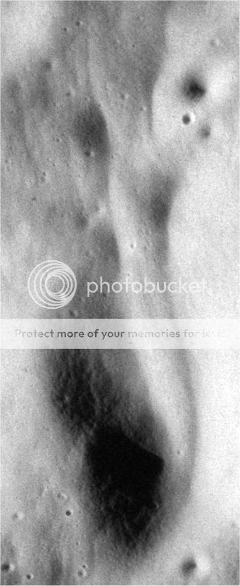
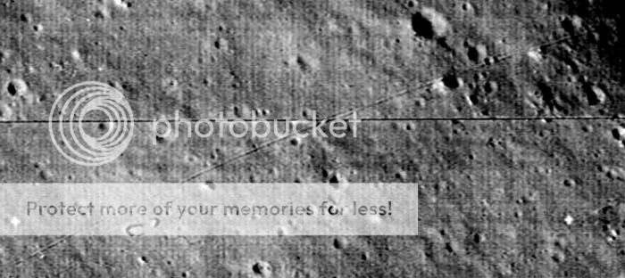
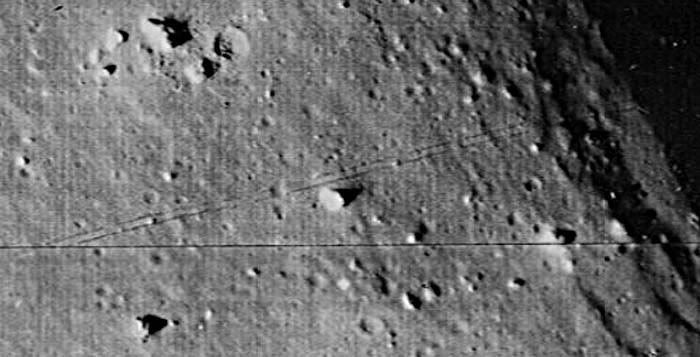
Found more sets of 'tracks'. They seem to emerge from the opposite side of the crater (Moltke?). They are located at the bottom of lo3-72-h2d which was taken in the same area as lo3-72-h2c.
LO3-72-H2D zoom (crater at left)
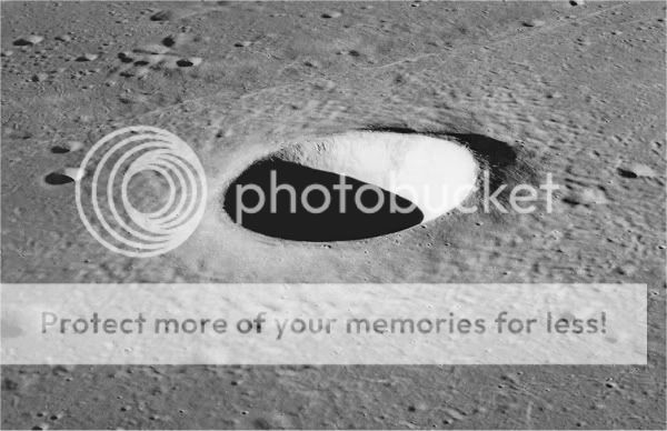
Moltke Crater, 7 kilometers in diameter, is an excellent example of a simple crater with a bowl-shaped interior and smooth walls. Such craters typically have depths that are about 20 percent of their diameters. The hummocky material surrounding the crater is Moltke's ejecta deposit.
Supposedly, the first 'men on the moon' got there two years and 5 months after these 'tracks' were photographed. They landed at Tranquility Base just about 31 miles northeast of Moltke Crater.
There are also more tracks' on the image lo3-72-h2b at the middle right. All three images were taken in the same area.
It seems that the 'tracks' are climbing up over the steep rim around Moltke Crater in image lo3-72-h2c, and then apparently down into the crater, since they seem to be coming out the opposite side. Must be something interesting down there since it would be much easier to go around.

Lunar Orbiter 3
Launched 05 February 1967
Imaged Moon: 15-23 February 1967
Apollo landing site survey mission
Apollo 11 was the first manned mission to land on the Moon. The first steps by humans on another planetary body were taken by Neil Armstrong and Buzz Aldrin on July 20, 1969. The astronauts also returned to Earth the first samples from another planetary body. Apollo 11 achieved its primary mission - to perform a manned lunar landing and return the mission safely to Earth - and paved the way for the Apollo lunar landing missions to follow.
What is the width of the 'tracks'?
Setting up the 3400 x 4678 pixels tiff image from lo3-72-h2c on my PSP7 at a 1:6 zoom ratio, I will attempt to determine the width of these 'tracks' leading down into Moltke Crater.
After a little trial and error, I have determined that a cut out 8.5 inch circle perfectly fits the crater radius on my screen. Moltke appears to be a circular crater from its images. Although different figures (6-7 km) are given, NASA claims Moltke is 7 km (4.35 miles) in diameter. Thus 8.5 inches = 22968 feet.
Choosing a spot which measures exactly 4.25 inches, that spot equates to 2826 pixels. I know; just rough measurements. Therefore the crater is 5652 pixels in diameter. Dividing 22968 by 5652 gives us one pixel = 4.06 feet. Center of top track to center of bottom track at right angles to the vector = 5 pixels. The width of the 'track' is 20.3 feet. Just a ball park figure working off an inaccurate monitor screen. If the crater diameter was off 500 pixels either way, the dimensions would be from 4.45 to 3.73 feet per pixel.
Of course we do not know how dependably the individual scans are joined together nor how accurately they depict the true circumference of the crater, but this gives us an idea of the size of objects we are viewing on the surface on this lo3-72-h2c image.
So if that 'track' was made by some type of vehicle, then a 18 to 23 foot width is within reason. The 'track' further down the image is almost 1 pixel narrower. There is a well-defined 'track' higher up and to the left which is 6 pixels wide. It shouldn't have been scanned from a lower altitude and the camera zoom level should not have changed, so the 'track' must be wider.
[edit on 8/30/08 by SPreston]
reply to post by SPreston
Thanks SP! You've really done your homework! So the 'tracks' seem to be around 20 feet broad, which as you mention is a reasonable width and not something that is hundreds of feet wide which will preclude the assumption of the 'track' theory.
The mystery deepens! Well there are just four options that emerge:
1. Man made - were we on the Moon in the early 50s? Possible.
2. ET made - Likely, but not impossible. We know next to zilch of what might have or is happening on the Moon!
3. Glitch in the pic - doesn't seem so.
4. Geological feature - Most unlikely considering the geometrics of the 'tracks'.
So now since option 3 and 4 can be ruled out, that means they are either man made or made by ETs. Now proving either is I think, impossible! At least for now!
Cheers!
[edit on 30-8-2008 by mikesingh]
reply to post by mikesingh
Can you PLEASE stop this nonsense. Don't you think the scores of trained astronomers around the world would bring these to our attention should we find anything interesting? It's a waste of everyone's time and effort to read through this futility, not to mention your own.
If there is life anywhere in the universe, people on ATS won't be the first ones to find it. People with real equipment and real training will.
Originally posted by dave420
Can you PLEASE stop this nonsense. It's a waste of everyone's time and effort to read through this futility, not to mention your own.
Pfffttt!! Then why the dickens are you here wasting YOUR time on THIS thread? Move on! And PLEASE don't waste OUR time with YOUR drivel and meaningless rhetoric.
If there is life anywhere in the universe, people on ATS won't be the first ones to find it. People with real equipment and real training will.
Which people will? The gov agencies like the three letter clubs? NASA? Don't be naive for chrissake. Get real.
Real equipment? Is someone including NASA using false equipment like the Lunar Orbiter?
[edit on 30-8-2008 by mikesingh]
Originally posted by mikesingh
reply to post by SPreston
Thanks SP! You've really done your homework! So the 'tracks' seem to be around 20 feet broad, which as you mention is a reasonable width and not something that is hundreds of feet wide which will preclude the assumption of the 'track' theory.
The mystery deepens! Well there are just four options that emerge:
1. Man made - were we on the Moon in the early 50s? Possible.
2. ET made - Likely, but not impossible. We know next to zilch of what might have or is happening on the Moon!
3. Glitch in the pic - doesn't seem so.
4. Geological feature - Most unlikely considering the geometrics of the 'tracks'.
So now since option 3 and 4 can be ruled out, that means they are either man made or made by ETs. Now proving either is I think, impossible! At least for now!
Cheers!
Mike I would add an option #5 which I have long considered the most likely. This option would also be man-made. Contemplating the distances between star systems and the almost total unliklihood that a life bearing planet would exist within possible stellar travel distance, I would rule out alien lifeforms unless they came into existence somewhere in our own solar system. Of course extra-dimensional lifeforms are an unknown possibility.
Assuming for the moment that the ancient biblical history is fairly accurate, we had our ancestors living for 700 to 800 years of age in a perhaps much more healthy environment. Just imagine if some of our own modern era geniuses such as Tesla or Edison or Bell had been given 700 to 800 years of good health for experimentation and learning and teaching. Imagine the inventions and advancements to civilization such persons could come up with.
I do not for a moment believe this 6000-7000 year creation timespan invented by modern-day religionists. Regardless the civilization produced before Noah must have been far advanced to our own. We with our great technology, cannot even reproduce the Great Pyramid with the same degree of mathematical accuracy. Whatever the Noahic Deluge actually entails, most likely a localized disaster created by an earthquake, volcanic eruption, or meteor impact, apparently that great civilization was destroyed here on earth.
However, what if they had colonized the moon? Cut off from any possibility of supplies from the earth, would they have survived? Would they have dug deep and become self-sufficient? Would they be powerful enough to warn off the current dominant conquering warpower on earth and advise us they want nothing to do with us and stay away?
Back to the 'tracks'. I do not believe they are of recent origin. Being partially and totally obscured by lunar dust in places, I would think they are hundreds or thousands of years old. As I understand it, the formation of lunar dust is a long slow steady process. Of course every impacting meteor or asteroid will stir up and add to the lunar dust. There are no ordinary wind conditions to drift the dust over tracks and objects. Perhaps these 'lunar colonizers' had no further use for such vehicles.
'Tracks' emerging from the opposite side of Moltke crater. They are located at the bottom of lo3-72-h2d which was taken in the same area as lo3-72-h2c.
reply to post by SPreston
What do you mean by "'Tracks' emerging from the opposite side of Moltke crater."? Photo lo3-72 only shows one side of the crater, and even less than half of it.
What do you mean by "'Tracks' emerging from the opposite side of Moltke crater."? Photo lo3-72 only shows one side of the crater, and even less than half of it.
new topics
-
US Air Force Secretary Kendall flies in cockpit of plane controlled by AI
Aircraft Projects: 1 hours ago -
Messages of Hope – Unity through AI
Dreams & Predictions: 2 hours ago -
Happy Cinco de mayo.
General Chit Chat: 3 hours ago -
The BEAST System of Revelation has been awoken and has assumed control, at least since COVID.
New World Order: 6 hours ago
top topics
-
HOUSE VOTES 320-91 TO BAN CHRISTIAN BELIEFS IN AMERICA
Political Issues: 17 hours ago, 10 flags -
The Department of Justice Spies on Congress with Google Assisting.
Political Conspiracies: 12 hours ago, 8 flags -
The BEAST System of Revelation has been awoken and has assumed control, at least since COVID.
New World Order: 6 hours ago, 6 flags -
Messages of Hope – Unity through AI
Dreams & Predictions: 2 hours ago, 1 flags -
US Air Force Secretary Kendall flies in cockpit of plane controlled by AI
Aircraft Projects: 1 hours ago, 1 flags -
Happy Cinco de mayo.
General Chit Chat: 3 hours ago, 0 flags
active topics
-
SC Jack Smith is Using Subterfuge Tricks with Donald Trumps Upcoming Documents Trial.
Dissecting Disinformation • 128 • : Vermilion -
Now is The Time to Tell Americans What Really Happened on 1.6.2021 at our U.S. Capitol.
Political Conspiracies • 198 • : WeMustCare -
Remember These Attacks When President Trump 2.0 Retribution-Justice Commences.
2024 Elections • 67 • : WeMustCare -
Russia Ukraine Update Thread - part 3
World War Three • 5759 • : bastion -
Really Unexplained
General Chit Chat • 120 • : andy06shake -
The adventure of publishing books
People • 11 • : DISRAELI2 -
Messages of Hope – Unity through AI
Dreams & Predictions • 3 • : WeMustCare -
Mood Music Part VI
Music • 3155 • : Hellmutt -
Happy Cinco de mayo.
General Chit Chat • 1 • : 5thHead -
US Air Force Secretary Kendall flies in cockpit of plane controlled by AI
Aircraft Projects • 0 • : Ophiuchus1