It looks like you're using an Ad Blocker.
Please white-list or disable AboveTopSecret.com in your ad-blocking tool.
Thank you.
Some features of ATS will be disabled while you continue to use an ad-blocker.

Navy Submarine Base Under the Nevada Desert?
page: 5share:
Originally posted by lonemaverick
Uh, I don't know about the others but not me. I would speculate that there are elevators that go down 3960 feet to the level of the sea. Elevators that go far deeper have been reported around the Edwards Air Force Base area, the Nevada Test Site and Dulce so it is certainly not a technical issue. Thanks for the post.
So are any of you going to try and explain the fact that the area is approximately 3960 feet above sea level yet maintains its water level?
Uh, I don't know about the others but not me. I would speculate that there are elevators that go down 3960 feet to the level of the sea. Elevators that go far deeper have been reported around the Edwards Air Force Base area, the Nevada Test Site and Dulce so it is certainly not a technical issue. Thanks for the post.
Nice story.
This little nugget reminds me of a different well-known story...
Hughes Glomar Explorer
This little nugget reminds me of a different well-known story...
A WELL-KNOWN U.S. nuclear submarine lost its way in these passages and disappeared forever. It was reported to have been lost IN OPEN SEA ELSEWHERE to keep the American people in total ignorance and to justify an enormous pay-off to an eccentric U.S. billionaire (who died in recent years) for providing the fictitious "recovery" effort.
Hughes Glomar Explorer
USNS Glomar Explorer (T-AG-193) is a large ship currently being used as a deep-sea drilling platform. The vessel was built for a secret operation, Project Jennifer, by the United States Central Intelligence Agency to recover a sunken Soviet submarine, K-129, which had been lost in April 1968.
I think the whole idea is very plausible. Living in So Cal something that concerns me now and always has is the fact that many say CA is floating and
will one day break off. I've been searching for map of the CA shelf etc... and have come up empty handed.
Does anyone have any maps or links that can show this shelf area of the state and the sea floor? How far does this shelf really extend under neighboring states?
Does anyone have any maps or links that can show this shelf area of the state and the sea floor? How far does this shelf really extend under neighboring states?
Syntaxstealth wrote
[very strange area. look at the base with google maps. good post John! for visual evidence use this (38.565998, -118.641357) in google maps to search. its very strange
38.565998, -118.641357]
I'm gonna have to go with it's water treatment. Any base, at least Marine Corps , has something similar. (see 29 palms)
Keep up the detective work! I LOVE this site!
First I have to say, being extremely familiar with the local geology, that unless you have some great new energy source to provide cooling for the
several hundred degree temperatures found relatively close to the surface, and some astounding "unobtanium" to withstand the constant strain and
numerous slipping faults, there is no way I can envision any tunnel system from most any point around Hawthorn to any point westward under the
Sierras. Walker lake is fishable, (some areas require a permit from the local tribe) skiable and swimable and the shallow end is on the south in the
restricted area. The security, currently, is fairly lax, but during the early part and buildup to the current war, security and activity was hectic. A
good sized naval weapon storage facility has to have a good war effort to "rotate" it's stock, and a lot of ordnance stored there was getting old.
The same situation occured during Gulf War 1, but to a lesser extent. There are some interesting structures in the canyons and mountains just west of
the bunkers, with well maintained roads, compared to the bunker areas on the flats.
And just to make a clear point: the circles found all over Nevada are not some secret military project. They are simply hay fields (vast majority are hay) The well or water source is in the center, and a (usually) 40 acre circle is produced by the pivot as it rotates around the center.Pulling a stuck section out of a bog is a chore, but the system as a whole works quite well if you have large areas of land and are not limited to rectangular farming. The water is limited to just the area the sprinklers will reach, and not much will grow outside of it, thus maximizing your overall productivity and conserving limited water supplies.
Not trying to rain on anyones parade, but hopefully providing a different view and some clarity.
Originally posted by gotrox
Thanks for your very informed post gotrox. The parade hasn't started yet, everybody is just getting here so your information is both welcome and appreciated.
First I have to say, being extremely familiar with the local geology, that unless you have some great new energy source to provide cooling for the several hundred degree temperatures found relatively close to the surface, and some astounding "unobtanium" to withstand the constant strain and numerous slipping faults, there is no way I can envision any tunnel system from most any point around Hawthorn to any point westward under the Sierras.
Not trying to rain on anyones parade, but hopefully providing a different view and some clarity.
Thanks for your very informed post gotrox. The parade hasn't started yet, everybody is just getting here so your information is both welcome and appreciated.
Thanks, John.
The area ( along with most of central and western Nevada) is geologically "hot" and seismicaly active. Which is quite nice for those of us that enjoy a nice dip on a cool evening in one of our many hot springs. The view of the heavens whilst soaking in the midst of the empty high desert, far from any light polution, is an experience everyone should have at least once.
The area ( along with most of central and western Nevada) is geologically "hot" and seismicaly active. Which is quite nice for those of us that enjoy a nice dip on a cool evening in one of our many hot springs. The view of the heavens whilst soaking in the midst of the empty high desert, far from any light polution, is an experience everyone should have at least once.
I found this little bit of information "Nevada's Humboldt River has no outlet to the ocean; the river sinks into the ground, feeding a massive
underground aquifer".
It seems winter snow/spring mountain run off can feed water anywhere within the sierras range and there is lava flow tubes under ground.
If there are lava flow tubes, than this story has some merit.
It seems winter snow/spring mountain run off can feed water anywhere within the sierras range and there is lava flow tubes under ground.
If there are lava flow tubes, than this story has some merit.
Originally posted by ignorant_ape
oh - and here
is a hi res crop of the area - its blatantly obvious that it is crops - you can even see a fallow area
Yes, blatantly obvious! But what you've shown are some 'crop circles' and squares in some other area. How about enlarging the huge bluish circle toward the left of the image I have posted? Could that be water or standing crop?
Yes. It's called "The Great Basin". All that runs in has no outlet. But as for massive aquifers, not really. Most valleys have lots of water, but
it is usually 50 to 100 feet down. Most valleys have at least 1 dry lake bed, that only during the wettest of years will show any surface water. The
whole great basin has been drying out for about the last 10,000 years, and evidence of that can be seen in many places. Most notable is around sand
mountain, east of Fallon. Not only desending water marks on the surrounding hills, but in petroglyphs above the high water mark, in what used to be a
shallow bay on a large lake. Though the water level has been in steady decline for thousands of years, the arrival of modern peoples just over a
hundred years ago has greatly increased the fall of the water table, especially the last 50 or so years with the availability of electricity for wells
and irrigation pressures. Amargosa valley has the best aquifer at this time, where the Amargosa river actually reaches the surface in places. Pressure
from the explosion in population in Pahrump is rapidly depleting this resource also. Just as walker lake is disapearing, so the subsurface lakes are
also by usage beyond input, and source diversion. The balance is precarious, so though I can't discount any large waterway underground, if large
amounts of water were flowing out, I think we would be in a larger mess in water availability than we are currently.
reply to post by mikesingh
The north end of the lake, and the Walker river where the photo is taken is Reservation land. I really couldn't tell you what is being grown, maybe alfalfa just after watering, maybe some other crop, maybe the angle of the sun, but the highway goes right past it and it is easily visible from the road.
The north end of the lake, and the Walker river where the photo is taken is Reservation land. I really couldn't tell you what is being grown, maybe alfalfa just after watering, maybe some other crop, maybe the angle of the sun, but the highway goes right past it and it is easily visible from the road.
Mr. Lear
Don't know if this is relevant or not....." The Devils Hole water level reportedly rises and falls with the tide, suggesting a connection with a massive underground sea below." I know people have disappeared while exploring Devil's Hole. Never to be found. Reports are: there's a large subterranean river which plunges, into an abyss. Wonder's how many disappeared, before it was fenced off? We plan on going to Devils Hole when the weather gets a little cooler. I'll try and get some good photo's. If we run across a Park Ranger maybe he/she will answer a few questions or Not.
Don't know if this is relevant or not....." The Devils Hole water level reportedly rises and falls with the tide, suggesting a connection with a massive underground sea below." I know people have disappeared while exploring Devil's Hole. Never to be found. Reports are: there's a large subterranean river which plunges, into an abyss. Wonder's how many disappeared, before it was fenced off? We plan on going to Devils Hole when the weather gets a little cooler. I'll try and get some good photo's. If we run across a Park Ranger maybe he/she will answer a few questions or Not.
Thanks for your post socalsonly. No, I am referring to that (wink-wink) system. I am refering to a completely separate Navy underground tube transportation system that extends world wide, the hub of which used to be below the submarine pens in San Diego and was accessed by an escalator. If you are uncomfortable with this question you might give us a simple "I can neither confirm nor deny..."
John, no one possesses a world-wide system. Please recognize something here; I’m not claiming to know everything, but I’m confident; at this point, our nation hasn’t exercised any contracts geared towards delivering that level of subterranean engineering. Yes; some subterranean work has been completed, but none of those accomplishments would blow your mind. Furthermore, I guarantee there are no escalators underneath the Point Loma Submarine Base or within the hillside of Ballast Point. There are only two subterranean areas located there; both are related to the era of Fort Rosecrans: Battery Point Loma and Battery Gillespie. For the most part, they are used for munitions storage, but that’s about it. However, they do possess an inspiring history.
No, I would be referring to the fully automated battleship "Fleet 21".
Well, "Fleet 21" refers to the 21st century class of warship, and so far, the only thing currently in actual production would be this: www.parsintl.com...
No, the one I am talking about is about 40 feet long and has an opening in the top for the ROV's. If you are uncomfortable with this question a simple..."I can neither confirm or deny" would be satisfactory.
I can neither confirm or deny
Originally posted by socalsonly
Thank you for the time and effort you put into answering my questions socalsonly. They are not only very informative but greatly appreciated.
I can neither confirm or deny
Thank you for the time and effort you put into answering my questions socalsonly. They are not only very informative but greatly appreciated.
ok John I had a better RV reading today, Its a huge cave that is shape like a cone thier is a tunnel that leads to the lake, inside the cave is white
because of the color of the rocks, I only saw one submarine I don't know what kind is it and don't know what they are doing there.
Also keep a watch for new picture of Saturn coming out this month, they were taken this week, it was a really strong RV vision that came to me, I
really don't know what they meant?
About The cave I been trying to get a reading where is located but I can get any good reading, you know you cann't rush readings.
About The cave I been trying to get a reading where is located but I can get any good reading, you know you cann't rush readings.
reply to post by mikesingh
I checked out the location on googlemaps. As gotrox asserted it's just crops. In fact it looks to be the growing season at the time this first, lower resolution image was taken.
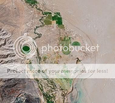
The next is a closer view of the "blueish"circle to the left of your image. It apparently was taken at a dryer time of year. You can see Highway 95 indeed runs right along next to it.
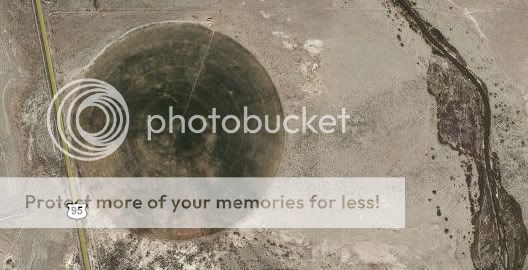
And here's the highest resolution available at googlemaps of the center of left circle.

Sorry, nothing to see here.
I checked out the location on googlemaps. As gotrox asserted it's just crops. In fact it looks to be the growing season at the time this first, lower resolution image was taken.
The next is a closer view of the "blueish"circle to the left of your image. It apparently was taken at a dryer time of year. You can see Highway 95 indeed runs right along next to it.
And here's the highest resolution available at googlemaps of the center of left circle.
Sorry, nothing to see here.
reply to post by mikesingh
no - they are not " in another area " - look at the lat / long i provided
they are right at the head of walker lake
if you want to persisit in your fantasies - fine
the circles and squares are crops
if you want to provide evidence to the contrary , fine
then YOU find an enlargement of the exact area you want
The Other Kind Of Crop Circles
There are many circular irrigation fields in Nevada, including some around Rachel which invariably draw attention when folks see them on Google earth.
I've seen some amazing theories regarding what they are, but I can attest that when viewed up close, they look remarkably like...
Circular irrigation fields.
reply to post by goosdawg
Ah! Thanx goosdawg, I_a and Majic. So that clears it up! Nothing anomalous there! I can now RIP!!
Cheers!
[edit on 3-9-2007 by mikesingh]
Ah! Thanx goosdawg, I_a and Majic. So that clears it up! Nothing anomalous there! I can now RIP!!
Cheers!
[edit on 3-9-2007 by mikesingh]
new topics
-
Putin, Russia and the Great Architects of the Universe
ATS Skunk Works: 2 hours ago -
A Warning to America: 25 Ways the US is Being Destroyed
New World Order: 6 hours ago
top topics
-
President BIDEN's FBI Raided Donald Trump's Florida Home for OBAMA-NORTH KOREA Documents.
Political Conspiracies: 12 hours ago, 29 flags -
A Warning to America: 25 Ways the US is Being Destroyed
New World Order: 6 hours ago, 12 flags -
Las Vegas UFO Spotting Teen Traumatized by Demon Creature in Backyard
Aliens and UFOs: 17 hours ago, 7 flags -
Is AI Better Than the Hollywood Elite?
Movies: 14 hours ago, 4 flags -
Maestro Benedetto
Literature: 14 hours ago, 1 flags -
Putin, Russia and the Great Architects of the Universe
ATS Skunk Works: 2 hours ago, 1 flags
active topics
-
Gaza Terrorists Attack US Humanitarian Pier During Construction
Middle East Issues • 42 • : 19Bones79 -
Krystalnacht on today's most elite Universities?
Social Issues and Civil Unrest • 6 • : FlyersFan -
Hate makes for strange bedfellows
US Political Madness • 50 • : 19Bones79 -
Weinstein's conviction overturned
Mainstream News • 28 • : burritocat -
Sunak spinning the sickness figures
Other Current Events • 25 • : Ohanka -
University of Texas Instantly Shuts Down Anti Israel Protests
Education and Media • 272 • : burritocat -
Cats Used as Live Bait to Train Ferocious Pitbulls in Illegal NYC Dogfighting
Social Issues and Civil Unrest • 24 • : NoviceStoic4 -
A Warning to America: 25 Ways the US is Being Destroyed
New World Order • 13 • : 2025yuga -
Is AI Better Than the Hollywood Elite?
Movies • 19 • : GENERAL EYES -
ChatGPT Beatles songs about covid and masks
Science & Technology • 24 • : iaylyan