It looks like you're using an Ad Blocker.
Please white-list or disable AboveTopSecret.com in your ad-blocking tool.
Thank you.
Some features of ATS will be disabled while you continue to use an ad-blocker.

Interstate 95 closed in SC from I20 in Florence SC to I26 due to flooding
page: 1share:
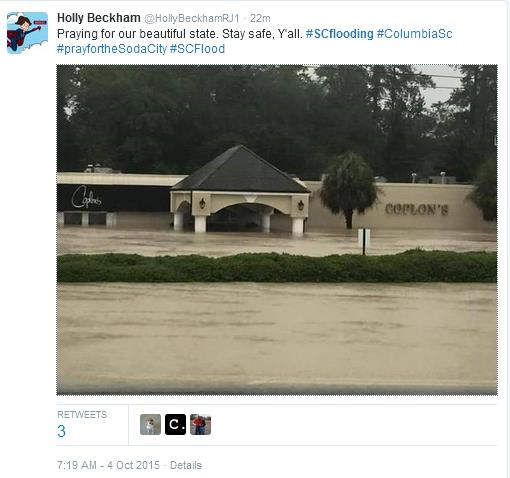
Stuff is happening fast and furious in Columbia SC - Catastrophic small lake dam failures near FT Jackson/ Gills Creek area. Bridge Failures Canon
Creek Road - Lexington Co; Caskets in Springfield Cemetary floating in Orangeburg Co; Parts of I77; I26: I20 closed due to flooding.
I95 closed via Breaking News
I95 closed via Breaking News
edit on 4-10-2015 by SCGrits because: add
info
CH19 WLTX live news coverage - click on top left icon Link
other links I'm following:
#scflooding
#scwx
#jimcantore TWC
#wxbrad Charlotte CH36 WCNC
I'll be back with more data when able - this stuff is unreal folks.
other links I'm following:
#scflooding
#scwx
#jimcantore TWC
#wxbrad Charlotte CH36 WCNC
I'll be back with more data when able - this stuff is unreal folks.
Last time I knew I95 closed was during an epic snowstorm in the 80's when it snowed all the way down to Fla I10.
Now they're saying Nat Guard called up at 9am but can't get to their post; 100's to 1000's of homes on the Gills Creek watershed that need to be checked. Fast water evac going on all over.
My dad's over 70 YO & he said he ani't never seen anything like this. Hugo wasn't even this bad.
Pet Store under water not know if animals are out - close to 5 feet of water there. WOW. Don't know what road yet, but Gills Creek watershed edit to add: Wildcat/ Ft Jackson Blvd area -this is where the triple dam breaches have occurred
edit on 4-10-2015 by SCGrits because: (no reason given)
Dam failures/topping so far this morning:
Barr Lake, Lexington SC
Lake Katherine, Gills Creek, Columbia SC Kilborn &Downing St - High water resuces from homes
Gibson Pond - two notch rd & Gibson RD area
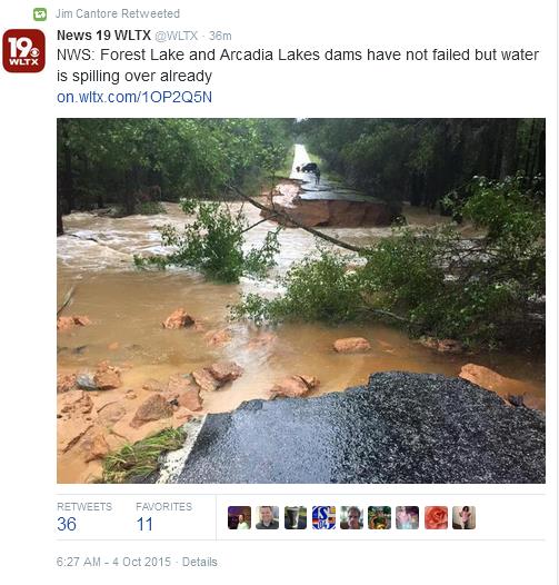
Forrest Lake -
Lexington Mill Pond - 12 mile creek
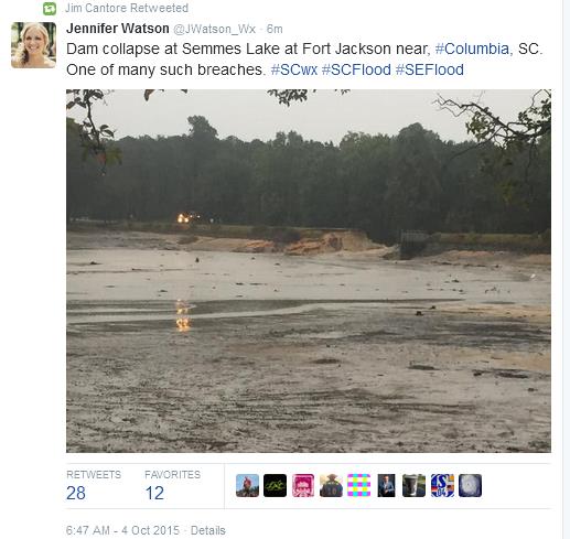
Semmes Lake at Ft Jackson
I20 at Broad River Closed
Barr Lake, Lexington SC
Lake Katherine, Gills Creek, Columbia SC Kilborn &Downing St - High water resuces from homes
Gibson Pond - two notch rd & Gibson RD area
Forrest Lake -
Lexington Mill Pond - 12 mile creek
Semmes Lake at Ft Jackson
I20 at Broad River Closed
This is awful. Stay safe SC members! Don't drive through deep water.
Thanks OP, keep us posted.
Thanks OP, keep us posted.
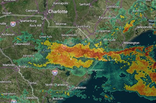
NOAA river levels
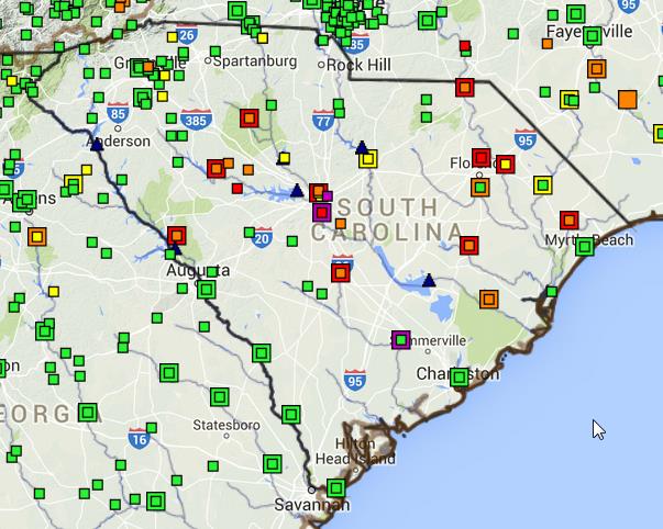 Red= at flood stage or flood stage eminent
another river gauge site NWS - Columbia
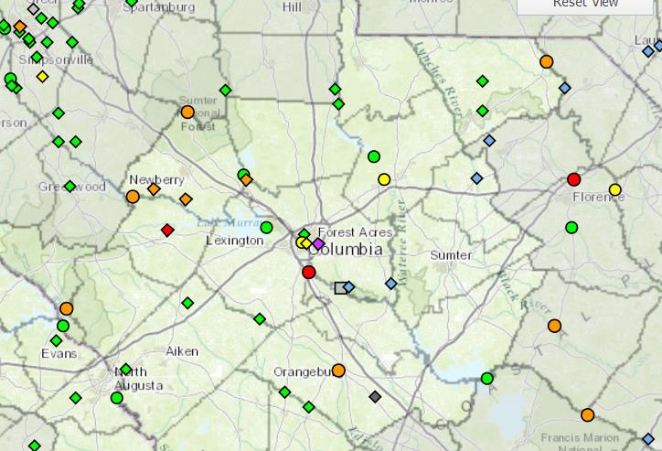
On each site just click on square/dot and another page will pop up with info on that gauge site
another river gauge site NWS - Columbia
On each site just click on square/dot and another page will pop up with info on that gauge site
originally posted by: kosmicjack
This is awful. Stay safe SC members! Don't drive through deep water.
Thanks OP, keep us posted.
Amen to that.
Thank's guys - thank's for prayers too - I have family in both Charleston & Columbia & upstate. So Far okay thank god! But it ain't over yet.
Fingers crossed.
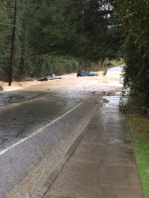
trying to figure out where this is
will add to edit later
I think this is just south of HWY 378/HWY76 aka Garner's Ferry Rd where the Gills Creek area failures -- 12-16" of rain since midnite I think- I believe that's what caused the catastrophic cascading multiple earthen dam failures.
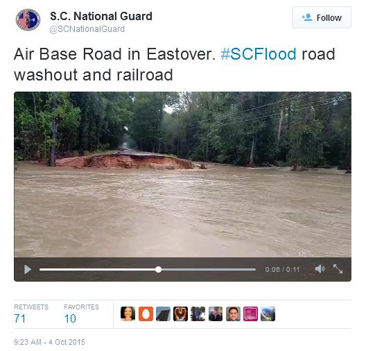
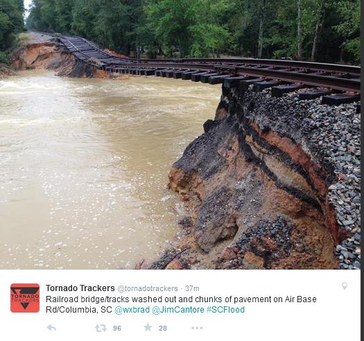
Airbase Road lead to McIntire JNGB - joint national Gaurd - These people trying to get to Guard duties and can't get there
Arkadia Lakes area - PPL can't get out b/c the roads have collapsed.
Gawd almighty what a Cluster $#%^ Our esteemed Gov Haley hasn't seen fit to make a comment or activate Nat Guard yet??? WTF???
edit on 4-10-2015 by SCGrits because: (no reason given)
Thanks for posting, mother nature trumps everything in life.
Best of luck and be safe.
Best of luck and be safe.
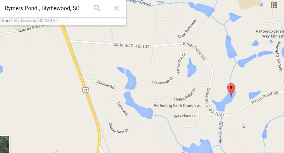
Per a tweet to CH19 live feed - another pond breach - Rimer Pond Road Blythewood on Rice Creek. As you can see these lakes/ponds are interconnected
and linked - when one goes, everything downstream stands a good chance to go too!
Schools and universities in the affected areas are putting out notices they'll be closed Mon--check with your local area. With so many roads and
bridges out I can see why.
a reply to: Eagleyedobserver
Thank you. I'm just north of all this mess, no rain, but lots of wind gusts - trees down in spots in Charlotte. If that fire hose rain stream shifts north then I'll be in the thick of it.
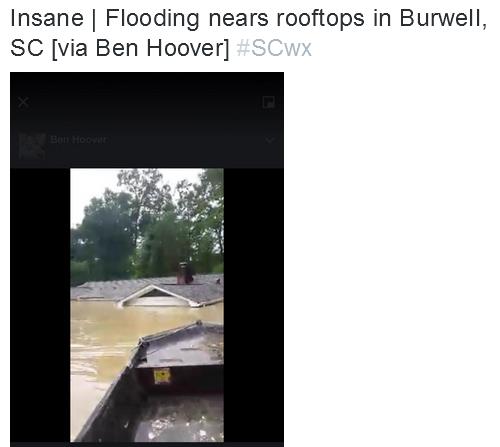
Just heard some ppl in Sumter Co being rescued from rooftops --my folks are in N. Sumter away from the swamp areas that are flooding.
Also, caskets floating in Sumter co at Evergreen Cemetery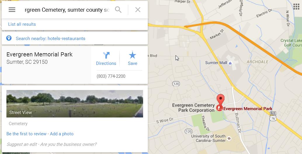
over 20" of rain in 3 days in Sumter.
Thank you. I'm just north of all this mess, no rain, but lots of wind gusts - trees down in spots in Charlotte. If that fire hose rain stream shifts north then I'll be in the thick of it.
Just heard some ppl in Sumter Co being rescued from rooftops --my folks are in N. Sumter away from the swamp areas that are flooding.
Also, caskets floating in Sumter co at Evergreen Cemetery
over 20" of rain in 3 days in Sumter.
edit on 4-10-2015 by SCGrits because: (no reason given)
I believe this was near the Columbia - Gills Creek dam failures on Burwell Lane off of Kilbourne Rd -lake Katherine failure/topping
a reply to: SCGrits
A times like these social media can do a lotta good.
Follow the emergency services tweets, wait it out, and don't go into the water-It may seem calm on the surface but it's what you can't see is the danger such as undercurrents and debris, and don't waste your phones battery power as you may need that later to receive future bulletins.
May the force be with you all.
new topics
-
Bigger than Covid
US Political Madness: 2 hours ago -
Modern Mind Control
General Conspiracies: 5 hours ago -
Trump Warns Time Magazine of Rising Anti-White Sentiment
2024 Elections: 7 hours ago -
Illegal Immigration Outlawed in Oklahoma Starting July 1
Social Issues and Civil Unrest: 7 hours ago -
California Must Spend 20 Billion on Power Grid Upgrades If It Wants EVs
Fragile Earth: 7 hours ago -
Young People Now Identifying as 'Gender Season' - seasogender, gender season, or gendersian
Social Issues and Civil Unrest: 8 hours ago -
Discussion on The Dover Demon
Cryptozoology: 8 hours ago -
Two lifeforms merge into one for first time in a billion years
Science & Technology: 8 hours ago -
What is "Genocide"?
US Political Madness: 10 hours ago
top topics
-
Illegal Immigration Outlawed in Oklahoma Starting July 1
Social Issues and Civil Unrest: 7 hours ago, 11 flags -
Two lifeforms merge into one for first time in a billion years
Science & Technology: 8 hours ago, 9 flags -
Trump Warns Time Magazine of Rising Anti-White Sentiment
2024 Elections: 7 hours ago, 8 flags -
California Must Spend 20 Billion on Power Grid Upgrades If It Wants EVs
Fragile Earth: 7 hours ago, 6 flags -
Bigger than Covid
US Political Madness: 2 hours ago, 4 flags -
Modern Mind Control
General Conspiracies: 5 hours ago, 4 flags -
Cambridge professor founds signs of life on another planet
Aliens and UFOs: 13 hours ago, 3 flags -
Discussion on The Dover Demon
Cryptozoology: 8 hours ago, 3 flags -
What is "Genocide"?
US Political Madness: 10 hours ago, 3 flags -
International law versus "rules-based order"
New World Order: 12 hours ago, 2 flags
active topics
-
George Knapp AMA on DI
Area 51 and other Facilities • 42 • : AW5150 -
Doctors Predict Epidemic of Prion Brain Diseases From mRna Jab
Health & Wellness • 49 • : nugget1 -
Illegal Immigration Outlawed in Oklahoma Starting July 1
Social Issues and Civil Unrest • 24 • : Disgusted123 -
Candidate TRUMP Now Has Crazy Judge JUAN MERCHAN After Him - The Stormy Daniels Hush-Money Case.
Political Conspiracies • 998 • : Vermilion -
Israel rejected early Hamas offer to free all civilians if IDF didn’t enter Gaza
Middle East Issues • 139 • : NorthOS -
Trump Warns Time Magazine of Rising Anti-White Sentiment
2024 Elections • 36 • : Disgusted123 -
Two lifeforms merge into one for first time in a billion years
Science & Technology • 32 • : Almanec -
Gov Kristi Noem Shot and Killed "Less Than Worthless Dog" and a 'Smelly Goat
2024 Elections • 154 • : matafuchs -
College protesters want amnesty.
US Political Madness • 205 • : Oldcarpy2 -
Mood Music Part VI
Music • 3140 • : TheWoker