It looks like you're using an Ad Blocker.
Please white-list or disable AboveTopSecret.com in your ad-blocking tool.
Thank you.
Some features of ATS will be disabled while you continue to use an ad-blocker.

Quake Watch 2015
page: 23share:
bet an heavy EQ is iminent at Chill...
an group blue finvishes stranded there....
bioligist speaks about an mystery stranding..
MSM Holland
www.nu.nl...
an group blue finvishes stranded there....
bioligist speaks about an mystery stranding..
MSM Holland
www.nu.nl...
a reply to: muzzy
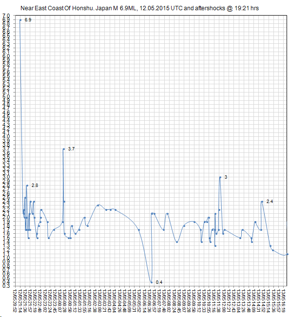
Update on the Near East Coast Of Honshu. Japan M 6.9ML, 12.05.2015 UTC and aftershocks @ 19:21 hrs
Yes 6.9, the latest NIED data shows that number, was 6.8 last night.
JMA official site still showing 6.6 as before
Still no Moderate aftershocks yet, would expect a few 4's and maybe a 5, but the largest has only been 3.7
strange
also unusual is the half circle of aftershocks curling away to the north of the mainshock, looks like a half "Mogi" (see ikimap below for best view of this)
interactive iki-Bingmap
@chiefsmom
absolutely, it is only 104km NNW of the 9.1, aftershocks can go on for decades.
rightclickviewimage for full size, or do whatever you have to do to see it bigger, just found rightclickviewimage doesn't work on Chrome, you have to Openimageinnewtab to see it full size
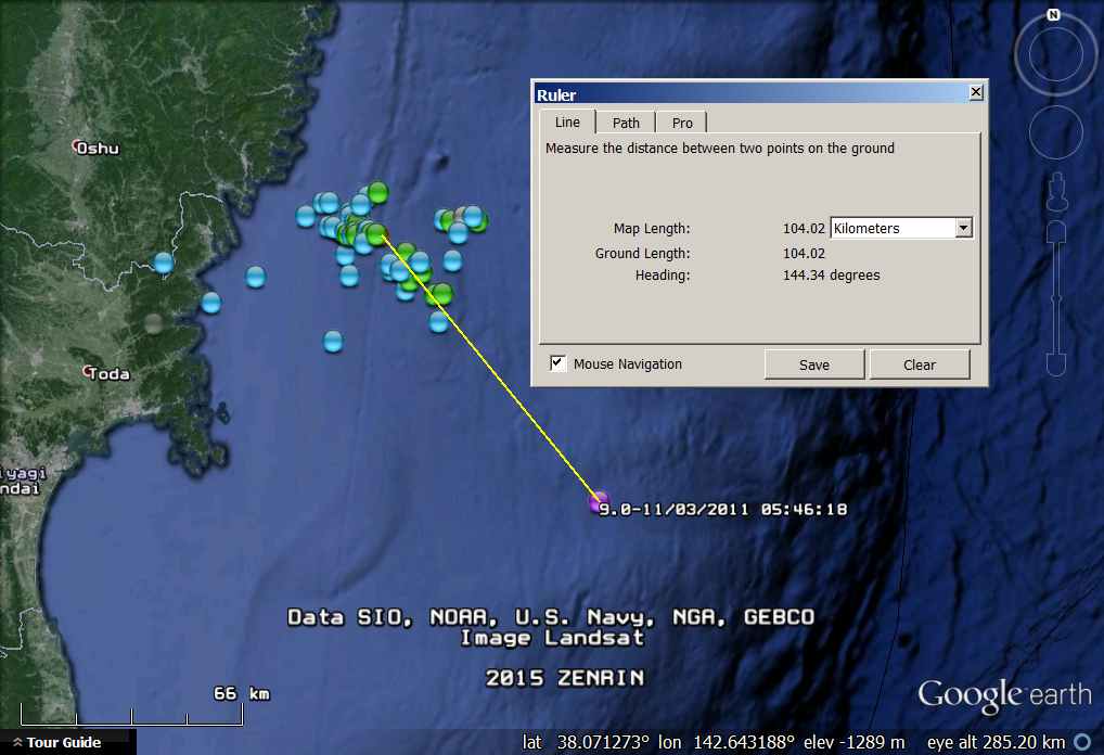
If we had enough data going back 10,000 years or more it is likely that every quake that occurs nowadays is an aftershock of some bigger one previously.
The determining factor for this one to be an aftershock is if it fitted inside the length of the Fault that the 9.1 occurred on?, that was massive, 650km long, and this one is well within the Fault.
Note: that 9.0 location on the image was from JMA, USelessGS have it even closer to the coast, 65km SE of yesterdays M6.6 (6.8?/6.9?)
Update on the Near East Coast Of Honshu. Japan M 6.9ML, 12.05.2015 UTC and aftershocks @ 19:21 hrs
Yes 6.9, the latest NIED data shows that number, was 6.8 last night.
JMA official site still showing 6.6 as before
Still no Moderate aftershocks yet, would expect a few 4's and maybe a 5, but the largest has only been 3.7
strange
also unusual is the half circle of aftershocks curling away to the north of the mainshock, looks like a half "Mogi" (see ikimap below for best view of this)
interactive iki-Bingmap
@chiefsmom
absolutely, it is only 104km NNW of the 9.1, aftershocks can go on for decades.
rightclickviewimage for full size, or do whatever you have to do to see it bigger, just found rightclickviewimage doesn't work on Chrome, you have to Openimageinnewtab to see it full size
If we had enough data going back 10,000 years or more it is likely that every quake that occurs nowadays is an aftershock of some bigger one previously.
The determining factor for this one to be an aftershock is if it fitted inside the length of the Fault that the 9.1 occurred on?, that was massive, 650km long, and this one is well within the Fault.
edit on 05u13213215 by muzzy because: (no reason given)
Note: that 9.0 location on the image was from JMA, USelessGS have it even closer to the coast, 65km SE of yesterdays M6.6 (6.8?/6.9?)
edit on
0500000013213215 by muzzy because: (no reason given)
small swarm beneath cone A898 in the Whakamaru caldera North Island, New Zealand 14/05/2015 UTC
[url=http://www.ikimap.com/node/495732/fullmap?BBOX=176.118515,-38.499436,176.159285,-38.485664&BASE=gphy] interactive iki-Terrain Map
[url=http://www.ikimap.com/node/495732/fullmap?BBOX=176.118515,-38.499436,176.159285,-38.485664&BASE=gphy] interactive iki-Terrain Map
Well did a search and could only find one more eq that had happened in this area. 3.4 back in 2014 and that was it looked as far back as 1800. It says
Texas but is located in Mexico go figure.
USGS
M4.0 - 84km S of Sanderson, Texas
29.393°N 102.558°W depth=15.8 km (9.8 mi)
Time
2015-05-14 17:41:14 (UTC)
2015-05-14 12:41:14 (UTC-05:00) in your timezone
Times in other timezones
Nearby Cities
84km (52mi) S of Sanderson, Texas
156km (97mi) W of Ciudad Acuna, Mexico
161km (100mi) W of Del Rio, Texas
181km (112mi) E of Ojinaga, Mexico
475km (295mi) W of Austin, Texas
USGS
edit on 14-5-2015 by lurksoften because: (no reason given)
M 5.1 - 34km E of Iwaki, Japan
earthquake.usgs.gov...
Time
2015-05-15 03:30:34 (UTC)
2015-05-14 20:30:34 (UTC-07:00) in your timezone
Times in other timezones
Nearby Cities
34km (21mi) E of Iwaki, Japan
53km (33mi) ENE of Kitaibaraki, Japan
57km (35mi) SSE of Namie, Japan
59km (37mi) NE of Takahagi, Japan
204km (127mi) NE of Tokyo, Japan
earthquake.usgs.gov...
edit on 14-5-2015 by phoenixlights321 because: (no reason
given)
Public ID 2015p362790
Intensity moderate
Universal Time May 15 2015, 5:34:35
NZ Standard Time Fri, May 15 2015, 5:34:35 pm
Depth 24 km
Magnitude 4.7
Location Within 5 km of Seddon
Latitude, Longitude -41.68, 174.08
Agency WEL(GNS_Primary)
www.geonet.org.nz...
the "doorometer" just told me this happened
I thought I felt a slight wobbling at first but thought it was a twitchy nerve in my leg
We have a door to the home office that is so delicately balanced it taps against a set of steel steps tucked in behind it when there is an earthquake. My other half said it went mental when we had that M6.2 in April
just now it tapped about 5 times, very gently
I checked the Geonet site and sure enough
wouldn't have felt it otherwise
I wonder if the number of times it taps indicates the magnitude size? 5 taps = 4.5-5.0 moderate
LOL
We just a a 1/10year storm with severe flooding in our area yesterday, Wellington was cut off by a landslide for 24 hrs, hopefully this doesn't trigger another landslide at the same spot. The Trains haven't been running for 48 hrs, roads, if passable, are chocked with traffic.
edit on
05u13413415 by muzzy because: some letters missing
Is anyone else watching Hawaii?
She's really rocking right now
She's really rocking right now
a reply to: crappiekat
Yea just wasnt posting to be told they happen all the time. But yes been keeping an eye on it over the last 36 hrs.
Also think some eq have been to the deflating of some lava that had built up.
Source
only alert i saw on the site was this from 11th.
Yea just wasnt posting to be told they happen all the time. But yes been keeping an eye on it over the last 36 hrs.
Also think some eq have been to the deflating of some lava that had built up.
May 12, 2015 - The summit lava lake in Halemaʻumaʻu Crater has dropped significantly over the past two days, as Kīlauea's summit has deflated. The dropping lava level has allowed lava veneer on the walls of the Overlook crater to fall away, clearly exposing the contact between the original rim of the Overlook crater (which is the original, pre-overflow floor of Halemaʻumaʻu Crater) and the stack of recent lava overflows. These overflows are roughly 8 meters (26 feet) thick in total
Source
only alert i saw on the site was this from 11th.
May 11, 2015 - Closures in Effect
Due to an increase in seismic activity along the East Rift Zone, all backcountry trails between Crater Rim Drive & the coast, as well as Kulanaokuaiki campground have been closed for overnight use. They remain open for day use.
edit on 15-5-2015 by lurksoften because: (no reason
given)
a reply to: crappiekat
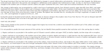
Hawaii has had my attention for the past week, crappiekat. Here is a screen grab of all the quakes the past 7 days, from USGS
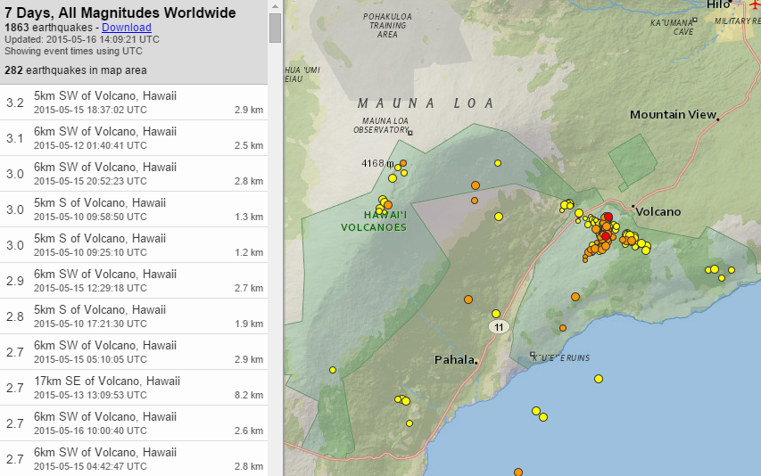
It looks to me, like the activity near Kilauea began in a line trending NW to SE, but has subsequently been cracking SW of the crater, toward the Southwest Rift Zone.
What is doubly interesting, is that Mauna Loa has experienced a few quakes, too. It hasn't had an eruption since 1984.
I haven't been able to find much chatter to determine if the Mauna Loa area quakes are raising eyebrows or not.
If anyone wants to check out the Hawaiian network seismos, here is the link from the Hawaiian Volcano Observatory.
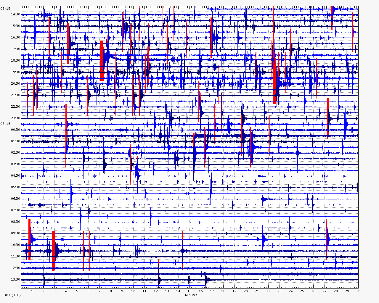
Here is a look at the past 24 hours of activity from a seismometer located near the south rim of Kilauea, station RIMD_HWZ_HV.
Busy.
Hawaii has had my attention for the past week, crappiekat. Here is a screen grab of all the quakes the past 7 days, from USGS
It looks to me, like the activity near Kilauea began in a line trending NW to SE, but has subsequently been cracking SW of the crater, toward the Southwest Rift Zone.
What is doubly interesting, is that Mauna Loa has experienced a few quakes, too. It hasn't had an eruption since 1984.
I haven't been able to find much chatter to determine if the Mauna Loa area quakes are raising eyebrows or not.
If anyone wants to check out the Hawaiian network seismos, here is the link from the Hawaiian Volcano Observatory.
Here is a look at the past 24 hours of activity from a seismometer located near the south rim of Kilauea, station RIMD_HWZ_HV.
Busy.
a reply to: lurksoften
Hi lurksoften,
Here is some more info concerning the change in lava lake level, and abrupt inflation/deflation changes at the southern end of the crater. From the HVO status page:
(ugh, for the life of me, I could not get the text to copy, so here is a pic of the status update)
(click the thumbnail for full-sized text)
This part got my attention:
ETA:
@AlexanderM, this activity is north of the big crack of the Hilina slump, but most certainly could influence it, especially if the shallow magma chamber keeps inflating.
Hi lurksoften,
Here is some more info concerning the change in lava lake level, and abrupt inflation/deflation changes at the southern end of the crater. From the HVO status page:
(ugh, for the life of me, I could not get the text to copy, so here is a pic of the status update)
(click the thumbnail for full-sized text)
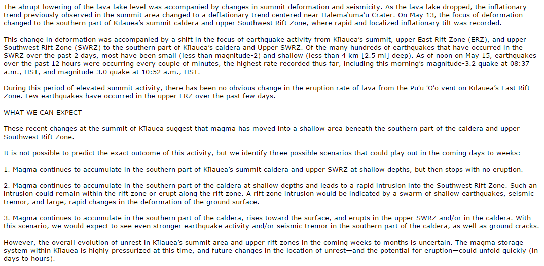
This part got my attention:
The magma storage system within Kilauea is highly pressurized at this time...
ETA:
@AlexanderM, this activity is north of the big crack of the Hilina slump, but most certainly could influence it, especially if the shallow magma chamber keeps inflating.
edit on 5/16/2015 by Olivine because: add response to
member
Let's keep an eye on that, as I believe it would be a larger landslide than El Hierro.
further to post by: muzzy
I have been following seismic activity since 10/5/2015 JST at Hakone volcano, Honshu, Japan,
Normally I wouldn't see it from the NIED/JMA data as I delete earthquakes below M1 for my Japan maps, but as mentioned in the reply link this jumped out at me.
It seems to have started 26/04/2015, prior to that there were just 1-5 x M~1 quakes per day there
latest activity has moved to the north end of Lake Ashi, it has increased and the magnitude sizes are getting bigger too
I'm looking at JMA reviewed data, which is 2 days old by the time it is posted on NIED. Preliminary data from NIED cannot be relied on.
It went nuts on 15/05/2015,
mag~1=197
mag1=101
mag2=9
total=307
here is a screenshot of that
here is a shot of 10/05.2015JUS
and one of all activity 10-15th JST
I'm building a series of gif maps like that and will make an animation.
I'm looking at data going back to 12/04/2015
Not sure what it all means, at first I wondered if given the fact this is a volcano and a thermal area, it might be a bit like the Geysers area in California, where there are micro-minor sized earthquakes every day, but it looks like this is a genuine "Swarm"
Eruption possible? who knows, it appears seismic swarms have occurred here in the past without a resulting eruption. 1980, 1991 and 2001.
from Smithsonian web site;
"The latest magmatic eruptive activity at Hakone about 2900 years ago produced a pyroclastic flow and a lava dome in the explosion crater, although phreatic eruptions took place as recently as the 12-13th centuries AD. Seismic swarms have occurred at Hakone during the 20th century. Lake Ashi, along with major thermal areas in the caldera, forms a popular resort area SW of Tokyo."
I'll gather all the bits together and do that animation and a few graphs.
A few links
Smithonian
Hakone (wiki)
Fuji-Hakone-Izu_National_Park (wiki)
I just found this page,
alert-raised-japans-hakone-earthquakes-continue/ from 06/05/2015 before it got really serious numbers of events per day, I bet they are freaking now!!!!!!!!!
edit on 05u13513515 by muzzy because: I just found a PDF that shows previous swarms at Hakone, from that I can go back on NIED and get the
data, if its there
edit on 05u13513515 by muzzy because: fixed a few spelling mistakes, hey more than on paagraph guaranteed to have
errors, and my r must have some dust unde the key
a reply to: Olivine
Thank you Olivine for replying.
I know that some say this is "Earthquake Season".
I too have kinda seen that pattern. However, When there's an uptick anywhere, It just peaks my interest. (Ya never Know).
Thank you also for the links.
Haven't seen you in a while. I hope everything is going well for you.
Crappiekat
addendum to: muzzy
this time limit for editing is a real PITA, there is NFW it has been 4 hours since I posted that.
overview of this recent swarm 26/4 to 15/5
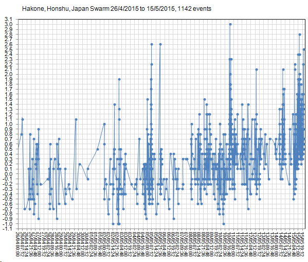
Note: not full size, rightclickviewimage or rightclickopeninnewtab
this time limit for editing is a real PITA, there is NFW it has been 4 hours since I posted that.
overview of this recent swarm 26/4 to 15/5
Note: not full size, rightclickviewimage or rightclickopeninnewtab
edit on 05u13513515 by muzzy because: (no reason given)
Thank you Muzzy.
I really appreciate your impute at the Quake Watch.
I really appreciate your impute at the Quake Watch.
new topics
-
Big Storms
Fragile Earth: 12 minutes ago -
Where should Trump hold his next rally
2024 Elections: 2 hours ago -
Shocking Number of Voters are Open to Committing Election Fraud
US Political Madness: 3 hours ago -
Gov Kristi Noem Shot and Killed "Less Than Worthless Dog" and a 'Smelly Goat
2024 Elections: 4 hours ago -
Falkville Robot-Man
Aliens and UFOs: 4 hours ago -
James O’Keefe: I have evidence that exposes the CIA, and it’s on camera.
Whistle Blowers and Leaked Documents: 5 hours ago -
Australian PM says the quiet part out loud - "free speech is a threat to democratic dicourse"...?!
New World Order: 6 hours ago -
Ireland VS Globalists
Social Issues and Civil Unrest: 6 hours ago -
Biden "Happy To Debate Trump"
2024 Elections: 7 hours ago -
RAAF airbase in Roswell, New Mexico is on fire
Aliens and UFOs: 7 hours ago
top topics
-
A Warning to America: 25 Ways the US is Being Destroyed
New World Order: 17 hours ago, 21 flags -
Blast from the past: ATS Review Podcast, 2006: With All Three Amigos
Member PODcasts: 9 hours ago, 13 flags -
James O’Keefe: I have evidence that exposes the CIA, and it’s on camera.
Whistle Blowers and Leaked Documents: 5 hours ago, 12 flags -
Australian PM says the quiet part out loud - "free speech is a threat to democratic dicourse"...?!
New World Order: 6 hours ago, 12 flags -
Biden "Happy To Debate Trump"
2024 Elections: 7 hours ago, 11 flags -
Mike Pinder The Moody Blues R.I.P.
Music: 9 hours ago, 8 flags -
What is the white pill?
Philosophy and Metaphysics: 8 hours ago, 6 flags -
Shocking Number of Voters are Open to Committing Election Fraud
US Political Madness: 3 hours ago, 5 flags -
Ireland VS Globalists
Social Issues and Civil Unrest: 6 hours ago, 5 flags -
RAAF airbase in Roswell, New Mexico is on fire
Aliens and UFOs: 7 hours ago, 5 flags
active topics
-
Biden "Happy To Debate Trump"
2024 Elections • 48 • : marg6043 -
Candidate TRUMP Now Has Crazy Judge JUAN MERCHAN After Him - The Stormy Daniels Hush-Money Case.
Political Conspiracies • 816 • : xuenchen -
Where should Trump hold his next rally
2024 Elections • 13 • : Edumakated -
Shocking Number of Voters are Open to Committing Election Fraud
US Political Madness • 6 • : marg6043 -
University of Texas Instantly Shuts Down Anti Israel Protests
Education and Media • 312 • : marg6043 -
Gov Kristi Noem Shot and Killed "Less Than Worthless Dog" and a 'Smelly Goat
2024 Elections • 30 • : TheMisguidedAngel -
Big Storms
Fragile Earth • 1 • : lilzazz -
President BIDEN's FBI Raided Donald Trump's Florida Home for OBAMA-NORTH KOREA Documents.
Political Conspiracies • 36 • : BingoMcGoof -
ALERT - U.S. President JOE BIDEN Examined and Found NOT OF SOUND MIND.
2024 Elections • 64 • : WeMustCare -
What is the white pill?
Philosophy and Metaphysics • 19 • : TheDiscoKing