It looks like you're using an Ad Blocker.
Please white-list or disable AboveTopSecret.com in your ad-blocking tool.
Thank you.
Some features of ATS will be disabled while you continue to use an ad-blocker.

Quake Watch 2015
page: 21share:
further to: muzzy
Been busy in the hills west of the Matukituki River overnight
up to 6:45:03 p.m. NZST last night
mag2= 24, mag3=10, mag4= 0, mag5= 1, total=35, total energy released=7376.738TTNT
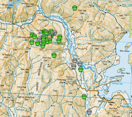
up to 3:41:38 a.m. NZST this morning
mag2= 73, mag3=21, mag4= 0, mag5= 1, total=95, total energy released=7429.102TTNT
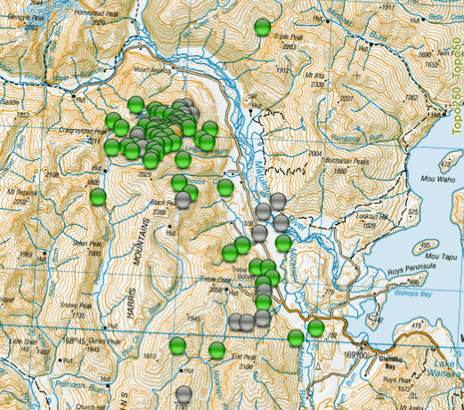
updated interactive map here
here is a timeline graph for 13 hrs of aftershocks
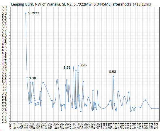
looks like a "classic" decay sequence for this quake, bit of a lag after the initial movement, then a resurgence at the 5 hr mark, then decreasing in size as time goes on.
Looking for a possible small M5 or mid to high M4 over the next few days, but not guaranteed, the 2014 Eketahuna 6.2MLv took 9 months to pop it's Baths Law largest aftershock (1.2 units less than the mainshock ) of 5.46ML, but that was an odd one, even though most of them were small the aftershocks seemed to go on forever. Different geology, Eke. was a Graben quake, looks like Wanaka is a Thrust quake.
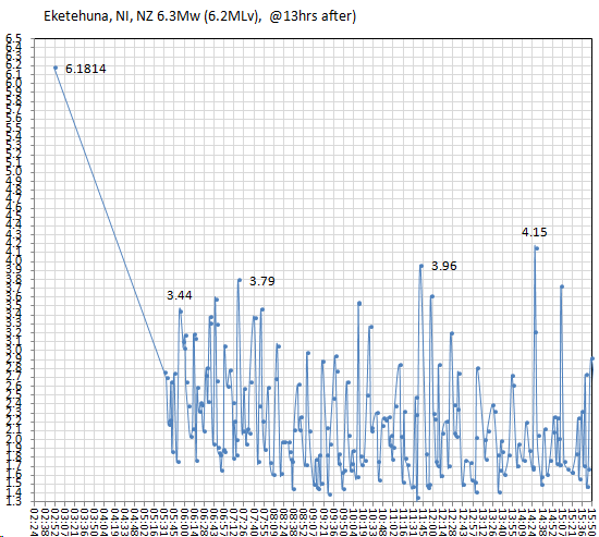
Eketahuna graph at the same timestamp fo comparison
Been busy in the hills west of the Matukituki River overnight
up to 6:45:03 p.m. NZST last night
mag2= 24, mag3=10, mag4= 0, mag5= 1, total=35, total energy released=7376.738TTNT
up to 3:41:38 a.m. NZST this morning
mag2= 73, mag3=21, mag4= 0, mag5= 1, total=95, total energy released=7429.102TTNT
updated interactive map here
here is a timeline graph for 13 hrs of aftershocks
looks like a "classic" decay sequence for this quake, bit of a lag after the initial movement, then a resurgence at the 5 hr mark, then decreasing in size as time goes on.
Looking for a possible small M5 or mid to high M4 over the next few days, but not guaranteed, the 2014 Eketahuna 6.2MLv took 9 months to pop it's Baths Law largest aftershock (1.2 units less than the mainshock ) of 5.46ML, but that was an odd one, even though most of them were small the aftershocks seemed to go on forever. Different geology, Eke. was a Graben quake, looks like Wanaka is a Thrust quake.
Eketahuna graph at the same timestamp fo comparison
I am hearing a 7.5 in PNG. Could trigger tsunami. trying to confirm now.
yep breaking news here now. 7.5 in the New Ireland region of Papua New Guinea
I just saw the 7.4 in PNG on GEE, that looks like a real whopper. It wouldn't surprise me much if it was upgraded to a stronger magnitude
Edit: And unless there's another one not yet listed elsewhere, it looks like it's already hitting the seismos in MI & FL that I watch. Yikes, that's a potent wave O.O
Edit: And unless there's another one not yet listed elsewhere, it looks like it's already hitting the seismos in MI & FL that I watch. Yikes, that's a potent wave O.O
edit on 5/4/2015 by Nyiah because: (no reason given)
#BREAKING: 'Hazardous tsunami waves' are possible for some parts of Papua New Guinea after a 7.5 quake off the New Ireland region.
a reply to: bellagirl
0.4m high is not too bad locally
My first thought was "how could there be a Tsunami when the quake was on land?"
of course across Waterfall Bay on the other side is Bovalpun and and further out across Jacquinot Bay is Pulpul and those other coastal villages mentioned in the list in the link below at max 0.4m
GDACS is the place to go to for Tsunami information, the Pacific Tsunami Center is useless.
edit on 05u12412415 by muzzy because: (no reason given)
Wanaka still active, but easing
edit on 0500000012412415 by muzzy because: (no reason given)
earthquake.usgs.gov...
M3.9 - 4km NNW of San Jacinto, California
Time
2015-05-06 07:39:47 (UTC)
2015-05-06 00:39:47 (UTC-07:00) in your timezone
Times in other timezones
Nearby Cities
4km (2mi) NNW of San Jacinto, California
8km (5mi) N of Hemet, California
11km (7mi) NW of Valle Vista, California
26km (16mi) ESE of Moreno Valley, California
41km (25mi) ESE of Riverside, California
41km (25mi) W of Palm Springs, California
1.3
4km NNW of San Jacinto, California
2015-05-06 00:51:45 UTC-07:0015.3 km
1.0
5km NNW of San Jacinto, California
2015-05-06 00:45:19 UTC-07:0014.6 km
1.5
4km NNW of San Jacinto, California
2015-05-06 00:42:04 UTC-07:0013.3 km
3.9
4km NNW of San Jacinto, California
2015-05-06 00:39:47 UTC-07:0015.3 km
edit on 7/30/2012 by dreamfox1 because: (no reason given)
M3.6 - 0km S of Concord, California
Nearby Cities
0km (0mi) S of Concord, California
3km (2mi) NE of Pleasant Hill, California
7km (4mi) NNE of Walnut Creek, California
9km (6mi) SW of Bay Point, California
82km (51mi) SW of Sacramento, California
earthquake.usgs.gov...
Cali is rumbling this morning.
This one is a bit close to San Fran.
3 in the last hour:
2.6 1km SSW of Concord, California 2015-05-06 07:35:12 UTC-07:00 13.2 km
3.6 0km S of Concord, California 2015-05-06 07:32:03 UTC-07:00 14.5 km
3.2 1km SSW of Concord, California 2015-05-06 07:01:47 UTC-07:00 13.9 km
edit on 6-5-2015 by Darkblade71 because: (no reason
given)
Public ID 2015p339684
Intensity severe
Universal Time May 6 2015, 16:23:54
NZ Standard Time Thu, May 7 2015, 4:23:54 am
Depth 11 km
Magnitude 5.0 (5.0344ML)
Location 50 km north-west of Milford Sound (offshore Big Bay West Coast SI)
Latitude, Longitude -44.25, 167.71
Agency WEL(GNS_Primary)
location map
Intensity severe
Universal Time May 6 2015, 16:23:54
NZ Standard Time Thu, May 7 2015, 4:23:54 am
Depth 11 km
Magnitude 5.0 (5.0344ML)
Location 50 km north-west of Milford Sound (offshore Big Bay West Coast SI)
Latitude, Longitude -44.25, 167.71
Agency WEL(GNS_Primary)
location map
edit on 05u12512515 by muzzy because: (no reason given)
timed out edit on: muzzy
even though it's a 5 it didn't release that much energy
o/s Big Bay 5.034= Energy Released: 537.19 tonnes of TNT
compared to
Wanaka's 5.69Mw = 7,356.46 TTNT
Awatere's M6.233= 33,735.66 TTNT
This made me finally get the map of M5's up on my NZ M5Blog, not sure why I took so long, I had a file done early April but never did anything with it. I have also brought the style in to line with NZ 2015 and Japan Blogs
Kermadecs are quiet this year (in comparison to recent previous years)
NZ 2015 M5s map
edit on 05u12512515 by muzzy because: (no reason given)
M7.2 - 136km SW of Panguna, Papua New Guinea
earthquake.usgs.gov...
Time
2015-05-07 07:10:22 (UTC)
2015-05-07 00:10:22 (UTC-07:00) in your timezone
Times in other timezones
Nearby Cities
136km (85mi) SW of Panguna, Papua New Guinea
148km (92mi) SW of Arawa, Papua New Guinea
416km (258mi) SE of Kokopo, Papua New Guinea
534km (332mi) ESE of Kimbe, Papua New Guinea
629km (391mi) WNW of Honiara, Solomon Islands
Updated info earthquake.usgs.gov...
M7.1 - 144km SW of Panguna, Papua New Guinea
Time
2015-05-07 07:10:22 (UTC)
2015-05-07 00:10:22 (UTC-07:00) in your timezone
Times in other timezones
Nearby Cities
144km (89mi) SW of Panguna, Papua New Guinea
156km (97mi) SW of Arawa, Papua New Guinea
406km (252mi) SE of Kokopo, Papua New Guinea
521km (324mi) ESE of Kimbe, Papua New Guinea
642km (399mi) WNW of Honiara, Solomon Islands
www.tsunami.gov...
000
WEPA40 PHEB 070720
TSUPAC
TSUNAMI MESSAGE NUMBER 1
NWS PACIFIC TSUNAMI WARNING CENTER EWA BEACH HI
0718 UTC THU MAY 7 2015
...PTWC TSUNAMI THREAT MESSAGE...
**** NOTICE **** NOTICE **** NOTICE **** NOTICE **** NOTICE *****
THIS MESSAGE IS ISSUED FOR INFORMATION ONLY IN SUPPORT OF THE
UNESCO/IOC PACIFIC TSUNAMI WARNING AND MITIGATION SYSTEM AND IS
MEANT FOR NATIONAL AUTHORITIES IN EACH COUNTRY OF THAT SYSTEM.
NATIONAL AUTHORITIES WILL DETERMINE THE APPROPRIATE LEVEL OF
ALERT FOR EACH COUNTRY AND MAY ISSUE ADDITIONAL OR MORE REFINED
INFORMATION.
**** NOTICE **** NOTICE **** NOTICE **** NOTICE **** NOTICE *****
PRELIMINARY EARTHQUAKE PARAMETERS
---------------------------------
* MAGNITUDE 7.2
* ORIGIN TIME 0710 UTC MAY 7 2015
* COORDINATES 7.2 SOUTH 154.7 EAST
* DEPTH 10 KM / 6 MILES
* LOCATION SOLOMON ISLANDS
EVALUATION
----------
* AN EARTHQUAKE WITH A PRELIMINARY MAGNITUDE OF 7.2 OCCURRED IN
THE SOLOMON ISLANDS AT 0710 UTC ON THURSDAY MAY 7 2015.
* BASED ON THE PRELIMINARY EARTHQUAKE PARAMETERS... HAZARDOUS
TSUNAMI WAVES ARE POSSIBLE FOR COASTS LOCATED WITHIN 300 KM OF
THE EARTHQUAKE EPICENTER.
TSUNAMI THREAT FORECAST...UPDATED
---------------------------------
* HAZARDOUS TSUNAMI WAVES FROM THIS EARTHQUAKE ARE POSSIBLE
WITHIN 300 KM OF THE EPICENTER ALONG THE COASTS OF
SOLOMON ISLANDS AND PAPUA NEW GUINEA
RECOMMENDED ACTIONS
-------------------
* GOVERNMENT AGENCIES RESPONSIBLE FOR THREATENED COASTAL AREAS
SHOULD TAKE ACTION TO INFORM AND INSTRUCT ANY COASTAL
POPULATIONS AT RISK IN ACCORDANCE WITH THEIR OWN EVALUATION...
PROCEDURES AND THE LEVEL OF THREAT.
* PERSONS LOCATED IN THREATENED COASTAL AREAS SHOULD STAY ALERT
FOR INFORMATION AND FOLLOW INSTRUCTIONS FROM NATIONAL AND
LOCAL AUTHORITIES.
ESTIMATED TIMES OF ARRIVAL
--------------------------
* ESTIMATED TIMES OF ARRIVAL -ETA- OF THE INITIAL TSUNAMI WAVE
FOR PLACES WITH AN ETA WITHIN THE NEXT SIX HOURS. ACTUAL
ARRIVAL TIMES MAY DIFFER AND THE INITIAL WAVE MAY NOT BE THE
LARGEST. A TSUNAMI IS A SERIES OF WAVES AND THE TIME BETWEEN
WAVES CAN BE FIVE MINUTES TO ONE HOUR.
www.tsunami.gov...
edit on 7/30/2012 by dreamfox1 because: (no reason given)
edit on 7/30/2012 by dreamfox1 because: (no
reason given)
edit on 7/30/2012 by dreamfox1 because: (no reason given)
edit on 7/30/2012 by dreamfox1 because: (no
reason given)
I read the alert given out by USGS and it said the waves would be 0.3 to 1 meter, pretty much similar to that which PNG experienced with the 7.5 quake
on the 4th. Still though, 3 7's within a month on one side of the world. This side has been relatively quiet in comparison. I've always believed
every action has a reaction.
Over the past few years, every sector of the ring of fire has had largish EQs to relieve pressure ... well ... all except one!
It is a concern to me that the North East quadrant, that is the section that runs along the North American continent, has not had any really big ones in a long time.
One would assume that the pressure just keeps building.
It is a worry
P
It is a concern to me that the North East quadrant, that is the section that runs along the North American continent, has not had any really big ones in a long time.
One would assume that the pressure just keeps building.
It is a worry
P
another 7.2 mag in New Guinea (SW of Panguna) this afternoon,
I'd say that sometime next week there will be a large one just north of there or just north of that undersea volcano near Oregon, they match up on a heat map and sine wave I've been using to work out my theory, they're also close to the same latitude with each other along the ring of fire.
Maybe I should put this in "Predictions" lol
a reply to: pheonix358
Agreed, it's been slow over on the coast line. It's been a few year now since I've seen a report of anything large. We've had small 3.2 in that area.
Agreed, it's been slow over on the coast line. It's been a few year now since I've seen a report of anything large. We've had small 3.2 in that area.
Well Texas is having its fair share of eq today.
USGS
Source
M4.0 - 5km NNW of Venus, Texas
32.480°N 97.132°W depth=3.2 km (2.0 mi)
Time
2015-05-07 22:58:05 (UTC)
2015-05-07 17:58:05 (UTC-05:00) in your timezone
Nearby Cities
5km (3mi) NNW of Venus, Texas
9km (6mi) S of Mansfield, Texas
12km (7mi) W of Midlothian, Texas
14km (9mi) SE of Rendon, Texas
252km (157mi) NNE of Austin, Texas
USGS
Parts of North Texas just experienced the most powerful earthquake so far to rumble through this part of the world: a 4.0-magnitude temblor in Venus, just south of Mansfield and west of Midlothian. According to the U.S. Geological Survey — and countless reports on Twitter and via email — it occurred at 5:58 p.m.
It was felt from Arlington to Mansfield, Midlothian to Alvarado, Cleburne to Dallas, according to the USGS. There’s even one report from as faraway as Austin.
Source
a reply to: lurksoften
USGS
M5.9 - 103km WSW of Sibolga, Indonesia
1.546°N 97.867°E depth=34.4 km (21.4 mi)
Time
2015-05-08 03:12:20 (UTC)
2015-05-07 22:12:20 (UTC-05:00) in your timezone
Nearby Cities
103km (64mi) WSW of Sibolga, Indonesia
156km (97mi) W of Padangsidempuan, Indonesia
185km (115mi) SSW of Kabanjahe, Indonesia
195km (121mi) ESE of Sinabang, Indonesia
459km (285mi) WSW of Kuala Lumpur, Malaysia
USGS
22 quake swarm south end of Lake Taupo overnight NZST, 2.69 the biggest.
Leaping Burn/Wanaka still pumping out the 3's and 2's (x9)
I've never really been happy with the thumbnails I have been doing this year on Blogger, the size they set is so small it is hard to get a map that small that you can decipher what is going on.
I have come up with this idea, a Pie Chart for each day thumbnail
couple of examples below;
NZ
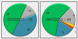
Japan
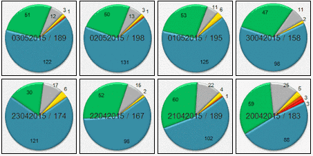
The colours match the magnitude colours of the icons on the maps, regular readers will figure that out themselves.
I think the Pies pretty well tell the story at a quick glance.
Japan basically gets a yellow M4 every day, but when a M5 hits you can obviously see that (orange) on the chart and go to that map. The Pies are reasonably clear images, unlike the maps thumbnails that make you squint to see what happened that day.
I'm not sure what makes readers click on a particular map (via the thumbnail) but I suspect based on the pageview stats that there is a morbid fascination with big earthquakes.
Leaping Burn/Wanaka still pumping out the 3's and 2's (x9)
I've never really been happy with the thumbnails I have been doing this year on Blogger, the size they set is so small it is hard to get a map that small that you can decipher what is going on.
I have come up with this idea, a Pie Chart for each day thumbnail
couple of examples below;
NZ
Japan
The colours match the magnitude colours of the icons on the maps, regular readers will figure that out themselves.
I think the Pies pretty well tell the story at a quick glance.
Japan basically gets a yellow M4 every day, but when a M5 hits you can obviously see that (orange) on the chart and go to that map. The Pies are reasonably clear images, unlike the maps thumbnails that make you squint to see what happened that day.
I'm not sure what makes readers click on a particular map (via the thumbnail) but I suspect based on the pageview stats that there is a morbid fascination with big earthquakes.
edit on 05u12712715 by muzzy because: Gad the ATS image loading is slooooooooow, ended up putting the wong image in the wrong place, fixed
now
new topics
-
Israel attacking Iran again.
Middle East Issues: 11 minutes ago -
Michigan school district cancels lesson on gender identity and pronouns after backlash
Education and Media: 15 minutes ago -
When an Angel gets his or her wings
Religion, Faith, And Theology: 1 hours ago -
Comparing the theology of Paul and Hebrews
Religion, Faith, And Theology: 1 hours ago -
Pentagon acknowledges secret UFO project, the Kona Blue program | Vargas Reports
Aliens and UFOs: 2 hours ago -
Boston Dynamics say Farewell to Atlas
Science & Technology: 3 hours ago -
I hate dreaming
Rant: 3 hours ago -
Man sets himself on fire outside Donald Trump trial
Mainstream News: 5 hours ago -
Biden says little kids flip him the bird all the time.
Politicians & People: 5 hours ago -
The Democrats Take Control the House - Look what happened while you were sleeping
US Political Madness: 6 hours ago
top topics
-
The Democrats Take Control the House - Look what happened while you were sleeping
US Political Madness: 6 hours ago, 16 flags -
In an Historic First, In N Out Burger Permanently Closes a Location
Mainstream News: 8 hours ago, 14 flags -
Biden says little kids flip him the bird all the time.
Politicians & People: 5 hours ago, 8 flags -
A man of the people
Medical Issues & Conspiracies: 13 hours ago, 8 flags -
Man sets himself on fire outside Donald Trump trial
Mainstream News: 5 hours ago, 7 flags -
Pentagon acknowledges secret UFO project, the Kona Blue program | Vargas Reports
Aliens and UFOs: 2 hours ago, 5 flags -
4 plans of US elites to defeat Russia
New World Order: 15 hours ago, 4 flags -
Sheetz facing racial discrimination lawsuit for considering criminal history in hiring
Social Issues and Civil Unrest: 6 hours ago, 3 flags -
Boston Dynamics say Farewell to Atlas
Science & Technology: 3 hours ago, 3 flags -
Are you ready for the return of Jesus Christ? Have you been cleansed by His blood?
Religion, Faith, And Theology: 11 hours ago, 3 flags
active topics
-
Israel attacking Iran again.
Middle East Issues • 4 • : Freeborn -
Michigan school district cancels lesson on gender identity and pronouns after backlash
Education and Media • 2 • : MetalThunder -
Candidate TRUMP Now Has Crazy Judge JUAN MERCHAN After Him - The Stormy Daniels Hush-Money Case.
Political Conspiracies • 402 • : Zanti Misfit -
The Democrats Take Control the House - Look what happened while you were sleeping
US Political Madness • 62 • : Kaiju666 -
Thousands Of Young Ukrainian Men Trying To Flee The Country To Avoid Conscription And The War
Other Current Events • 50 • : DBCowboy -
I hate dreaming
Rant • 6 • : Hecate666 -
Israeli Missile Strikes in Iran, Explosions in Syria + Iraq
World War Three • 102 • : DumbNut -
Man sets himself on fire outside Donald Trump trial
Mainstream News • 32 • : cherokeetroy -
Pentagon acknowledges secret UFO project, the Kona Blue program | Vargas Reports
Aliens and UFOs • 5 • : Ophiuchus1 -
-@TH3WH17ERABB17- -Q- ---TIME TO SHOW THE WORLD--- -Part- --44--
Dissecting Disinformation • 546 • : MetalThunder