It looks like you're using an Ad Blocker.
Please white-list or disable AboveTopSecret.com in your ad-blocking tool.
Thank you.
Some features of ATS will be disabled while you continue to use an ad-blocker.

Quake Watch 2015
page: 1share:
following on from;
(starting at page 1)
Quake Watch 2014
Quake Watch 2013
Quake Watch 2012
Quake Watch 2011
Quake Watch 2010
Quake Watch 2009
Quake Watch 2008
Quake Watch 2007
Quake Watch 2006
Quake Watch 2004
2003 (World Wide Seismic Event...)
EARTHQUAKE LINKS
Often the source pages change the address during the year, these are the latest links I have been using towards the end of 2014.
Those with a * have changed address since Jan 2014, those with ** are new links
Lists type
IRIS Wilber 3
USGS* Last7 Days
GFZ
EMSC
LDEO
BGS British Isles, last 50 days
ITALY last month
GREECE NOA, search too
NORSAR Scandanavia, last week
INETER Central America, Guatemala last 10 days
MEXICO last year, Felt
COSTA RICA
CHILE last day
TURKEY* KOERI
GEONET NZ last 30 quakes
JMA Japan, last week
FINLAND Northern Europe coverage
ICELAND
CYPRUS**
edit on 1200000036436414 by muzzy because: (no reason given)
First Quake of 2015? based on NZDT, offshore Taranaki, NZ, 215.4 km NW of me
Public ID 2014p985053
Intensity light
Universal Time December 31 2014, 11:16:39
NZ Daylight Time Thu, Jan 1 2015, 12:16:39 am
Depth 5 km
Magnitude 2.8
Location 60 km west of Opunake
Latitude, Longitude -39.57, 173.15
www.geonet.org.nz...
edit on 12u36436414 by muzzy because: (no reason given)
edit on 1200000036436414 by muzzy because: made heaps of mistakes
posting this edited 4 times!!. bloody neighbourhood was like a battlezone last night Fireworks started going off at 11am then ended around 12:30. Not
everyone wants to stay up that late!. No consideration!, things like that start Wars! Will have to take an aftrenoon nap now.
Thank you Muzzy for all you do!
You and Puterman, (where has he gone off to?), are the go to guys for this stuff.
To all my other Quaker Family, much love and blessings. Here's to hoping for a smooth ride in 2015!
You and Puterman, (where has he gone off to?), are the go to guys for this stuff.
To all my other Quaker Family, much love and blessings. Here's to hoping for a smooth ride in 2015!
First 18 quakes of 2015, UTC time
Prov,Date/Time UTC,Latitude,Longitude,Magnitude,Depth(Km),Location
usgs,2015-01-01 00:27:24, 38.786, -122.778, 1.3, 2.4, Nthn California (36)
usgs,2015-01-01 00:45:11, 53.742, -165.626, 4.1, 61.6, Fox Isls. Aleutian Isls. (9)
usgs,2015-01-01 00:52:10, 38.047, -118.758, 2.2, 11.7, California-Nevada Border Region (40)
geonet,2015-01-01 01:08:44, -38.096, 178.220, 2.7, 12.3, Matahi-Matawai-Tolaga Bay-Ruatoria Knoll
geonet,2015-01-01 01:28:44, -37.772, 176.763, 2.3, 7.2, Raglan Hbr.-Tauranga-Whakatane
emsc,2015-01-01 01:34:23, 39.530, 51.520, 3.0, 62.0, Caspian Sea
usgs,2015-01-01 01:40:54, 64.864, -148.687, 1.0, 15.9, Central Alaska (1)
usgs,2015-01-01 01:42:35, 59.757, -152.441, 2.2, 72.5, Sthn Alaska (2)
usgs,2015-01-01 01:54:30, 38.795, -122.750, 1.1, 0.8, Nthn California (36)
emsc,2015-01-01 01:57:30, 43.310, 12.560, 2.0, 9.0, Central Italy
usgs,2015-01-01 02:23:27, 41.870, -119.621, 1.5, 6.5, Nevada (37)
usgs,2015-01-01 02:26:37, 61.542, -140.673, 2.0, 0.5, Sthn Yukon Territory. Canada (18)
usgs,2015-01-01 02:53:01, 65.189, -149.058, 1.1, 5.6, Nthn Alaska (676)
emsc,2015-01-01 02:54:21, 38.610, 16.230, 2.4, 7.0, Sthn Italy
usgs,2015-01-01 03:04:24, 38.834, -122.807, 1.5, 2.8, Nthn California (36)
emsc,2015-01-01 03:12:34, 36.500, -89.600, 2.3, 10.0, Seern Missouri
usgs,2015-01-01 03:12:34, 36.496, -89.595, 2.3, 9.9, New Madrid. Missouri Region (486)
geonet,2015-01-01 03:41:52, -41.228, 173.474, 2.0, 79.2, Kahurangi-Nelson
data gathered using Puterman's QVS Data Pro program.
edit on 1200000036436414 by muzzy because: (no reason given)
This thread needs a bump.!!!
Happy New Year Everyone.
May this year be a safe one.
That 5.1 on the "Juan De Fuch" caught my eye.
Been watching the PNW since all the storms they have been having. Lot's of water, whats it gonna do???
Happy New Year Everyone.
May this year be a safe one.
That 5.1 on the "Juan De Fuch" caught my eye.
Been watching the PNW since all the storms they have been having. Lot's of water, whats it gonna do???
edit on 1-1-2015 by crappiekat because: (no reason given)
Good Evening, I mean, Happy New Year.
Something nearish to Yellowstone. Maybe Utah. Nothing on USGS yet. (edit. 4.9M, Idaho)
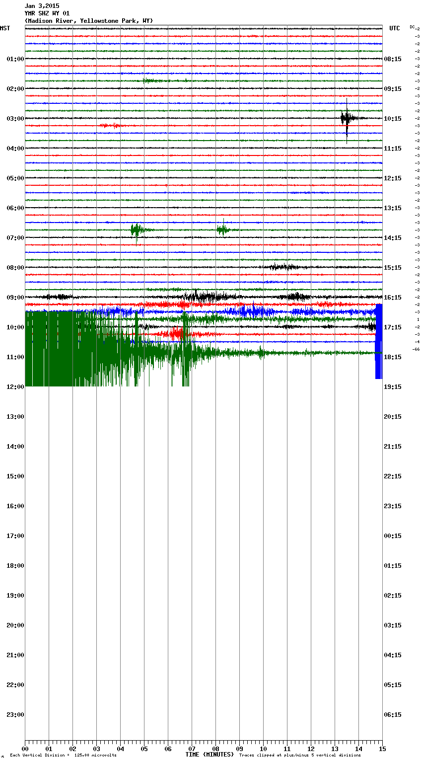
Idaho. 4.9M. I'm guessing it's near those other "mysterious" earthquakes. That may, or may not have anything to do with Yellowstone. Cough- Yellowstone is inflating.
Edit. The epicenter is near the swarm. Here's a report I got a while back and thought it would be important. Rather than me ramble, this article does a good job of hinting this may all have to do with big Yeller'.
missoulian.com... html
From the article,
"BOISE, Idaho (AP) — The latest earthquake swarm in central Idaho could help scientists better understand quake belts extending from Yellowstone National Park.
The most recent swarm in the Challis area started this week and so far 20 quakes have been recorded, the largest a magnitude 3.7 on Monday.
"There's obviously a fault down there at depth to produce these, and the town of Challis happens to be built on top of it," said scientist Mike Stickney of the Montana Bureau of Mines and Geology based in Butte, Montana. "We have no indication that it's leading to a larger event."
The quakes are occurring at the northern tip of the Lost River Fault but it's not clear if that fault is involved or if an unknown fault is at work. The Lost River Fault caused Idaho's largest recorded quake, a magnitude 6.9, rumbling in 1983 near 12,667-foot Borah Peak, Idaho's tallest peak.
Scientists brought in portable seismographs to monitor an earthquake swarm last summer. Most were removed after the swarm stopped but one was left in place.
It "completely stopped and then just a couple days ago it started up again," said Melanie Corrigan, a dispatcher with the Custer County Sheriff's Office. "People are just like, 'Oh, great, here we go again.'"
She said no damage has been reported.
Stickney said the quakes are being produced by different triggers, indicating a complex process that's poorly understood. The swarms are occurring within the Centennial Tectonic Belt extending west from Yellowstone National Park. The Intermountain Seismic Belt extends north and south from Yellowstone through multiple states.
The park is well known as a geologic hotspot, sitting atop magma. But scientists said that doesn't explain the earthquake swarms in Idaho.
"It clearly is somehow related," Stickney said. "I'm not blaming the belts on Yellowstone, but the fact that they extend into and out of Yellowstone is not a coincidence."
Also perplexing, scientists say, is that the earthquakes are so far from tectonic plates on the West Coast.
"That's the fundamental question that we don't know," Stickney said. "It's related to plate tectonics, but no one knows why this is occurring so far from a plate boundary. Nobody understands why these belts are located where they are."
Kris Pankow, associate director of the University of Utah Seismograph Stations, with Stickney earlier this month presented their findings about last summer's Challis Swarm, as it's called, to fellow scientists at the 2014 American Geophysical Union in San Francisco.
"It's interesting scientifically because there are so many things going on," Pankow said. "At what level you link these earthquakes I'm not sure."
She said she's mainly interested in the Idaho quakes as a way to better understand the Intermountain Seismic Belt. But so far, the Idaho quakes have been hard to figure out. Possible causes of the quakes include stretching of the crust or heated water moving about.
"I'm not sure which it is, to be honest, or it might be something completely different," she said.
She said there's still information to be analyzed from last summer's swarm, plus additional information from the latest swarm.
Challis residents are hoping not too much more information is produced.
"We don't have anything to do with it and we can't predict when the next one is going to happen," said Corrigan, the Custer County dispatcher. Residents "are kind of uneasy about it."
Here's another story,
www.spokesman.com...
The swarm has been occurring for quite some time now. About the same period as the uplift. hmmm
www.abovetopsecret.com...
One more ting. I obsess about the moon and our orbit in relation to the sun. I think it matters. I just so happens I believe this cycle affects magma deep in the earth. If the magma is travelling along under Idaho, then maybe there is pressure causing all this noise. Tonight, is our perihelion. I was just think about perihelion the other day. I was noting how stupid it was to have new year's on Jan 1. I think it should be Jan 4, when we are closest to our best pal, the sun. earthsky.org...
shhhhhh. ( my son is claiming that all I do is boring stuff) and ( it is an abomination that I have 9 webpages open at once, and is challenging me to open more.)
I just wanted to add that it's almost a full moon as well.
Something nearish to Yellowstone. Maybe Utah. Nothing on USGS yet. (edit. 4.9M, Idaho)
edit on 3-1-2015 by ericblair4891 because: (no reason given)
Idaho. 4.9M. I'm guessing it's near those other "mysterious" earthquakes. That may, or may not have anything to do with Yellowstone. Cough- Yellowstone is inflating.
Edit. The epicenter is near the swarm. Here's a report I got a while back and thought it would be important. Rather than me ramble, this article does a good job of hinting this may all have to do with big Yeller'.
missoulian.com... html
From the article,
"BOISE, Idaho (AP) — The latest earthquake swarm in central Idaho could help scientists better understand quake belts extending from Yellowstone National Park.
The most recent swarm in the Challis area started this week and so far 20 quakes have been recorded, the largest a magnitude 3.7 on Monday.
"There's obviously a fault down there at depth to produce these, and the town of Challis happens to be built on top of it," said scientist Mike Stickney of the Montana Bureau of Mines and Geology based in Butte, Montana. "We have no indication that it's leading to a larger event."
The quakes are occurring at the northern tip of the Lost River Fault but it's not clear if that fault is involved or if an unknown fault is at work. The Lost River Fault caused Idaho's largest recorded quake, a magnitude 6.9, rumbling in 1983 near 12,667-foot Borah Peak, Idaho's tallest peak.
Scientists brought in portable seismographs to monitor an earthquake swarm last summer. Most were removed after the swarm stopped but one was left in place.
It "completely stopped and then just a couple days ago it started up again," said Melanie Corrigan, a dispatcher with the Custer County Sheriff's Office. "People are just like, 'Oh, great, here we go again.'"
She said no damage has been reported.
Stickney said the quakes are being produced by different triggers, indicating a complex process that's poorly understood. The swarms are occurring within the Centennial Tectonic Belt extending west from Yellowstone National Park. The Intermountain Seismic Belt extends north and south from Yellowstone through multiple states.
The park is well known as a geologic hotspot, sitting atop magma. But scientists said that doesn't explain the earthquake swarms in Idaho.
"It clearly is somehow related," Stickney said. "I'm not blaming the belts on Yellowstone, but the fact that they extend into and out of Yellowstone is not a coincidence."
Also perplexing, scientists say, is that the earthquakes are so far from tectonic plates on the West Coast.
"That's the fundamental question that we don't know," Stickney said. "It's related to plate tectonics, but no one knows why this is occurring so far from a plate boundary. Nobody understands why these belts are located where they are."
Kris Pankow, associate director of the University of Utah Seismograph Stations, with Stickney earlier this month presented their findings about last summer's Challis Swarm, as it's called, to fellow scientists at the 2014 American Geophysical Union in San Francisco.
"It's interesting scientifically because there are so many things going on," Pankow said. "At what level you link these earthquakes I'm not sure."
She said she's mainly interested in the Idaho quakes as a way to better understand the Intermountain Seismic Belt. But so far, the Idaho quakes have been hard to figure out. Possible causes of the quakes include stretching of the crust or heated water moving about.
"I'm not sure which it is, to be honest, or it might be something completely different," she said.
She said there's still information to be analyzed from last summer's swarm, plus additional information from the latest swarm.
Challis residents are hoping not too much more information is produced.
"We don't have anything to do with it and we can't predict when the next one is going to happen," said Corrigan, the Custer County dispatcher. Residents "are kind of uneasy about it."
Here's another story,
www.spokesman.com...
The swarm has been occurring for quite some time now. About the same period as the uplift. hmmm
www.abovetopsecret.com...
edit on 3-1-2015 by ericblair4891 because: (no reason given)
edit on 3-1-2015 by ericblair4891 because: (no reason
given)
edit on 3-1-2015 by ericblair4891 because: (no reason given)
edit on 3-1-2015 by ericblair4891 because: (no
reason given)
One more ting. I obsess about the moon and our orbit in relation to the sun. I think it matters. I just so happens I believe this cycle affects magma deep in the earth. If the magma is travelling along under Idaho, then maybe there is pressure causing all this noise. Tonight, is our perihelion. I was just think about perihelion the other day. I was noting how stupid it was to have new year's on Jan 1. I think it should be Jan 4, when we are closest to our best pal, the sun. earthsky.org...
edit on 3-1-2015 by ericblair4891 because: (no reason given)
shhhhhh. ( my son is claiming that all I do is boring stuff) and ( it is an abomination that I have 9 webpages open at once, and is challenging me to open more.)
I just wanted to add that it's almost a full moon as well.
edit on 3-1-2015 by ericblair4891 because: (no reason given)
edit on 3-1-2015 by ericblair4891 because: (no reason
given)
M 4.9 - 7km E of Challis, Idaho
Time
2015-01-03 11:44:03 UTC-06:00
Location
44.504°N 114.136°W
Depth
8.2km
Time
2015-01-03 11:44:03 UTC-06:00
Location
44.504°N 114.136°W
Depth
8.2km
earthquake.usgs.gov...
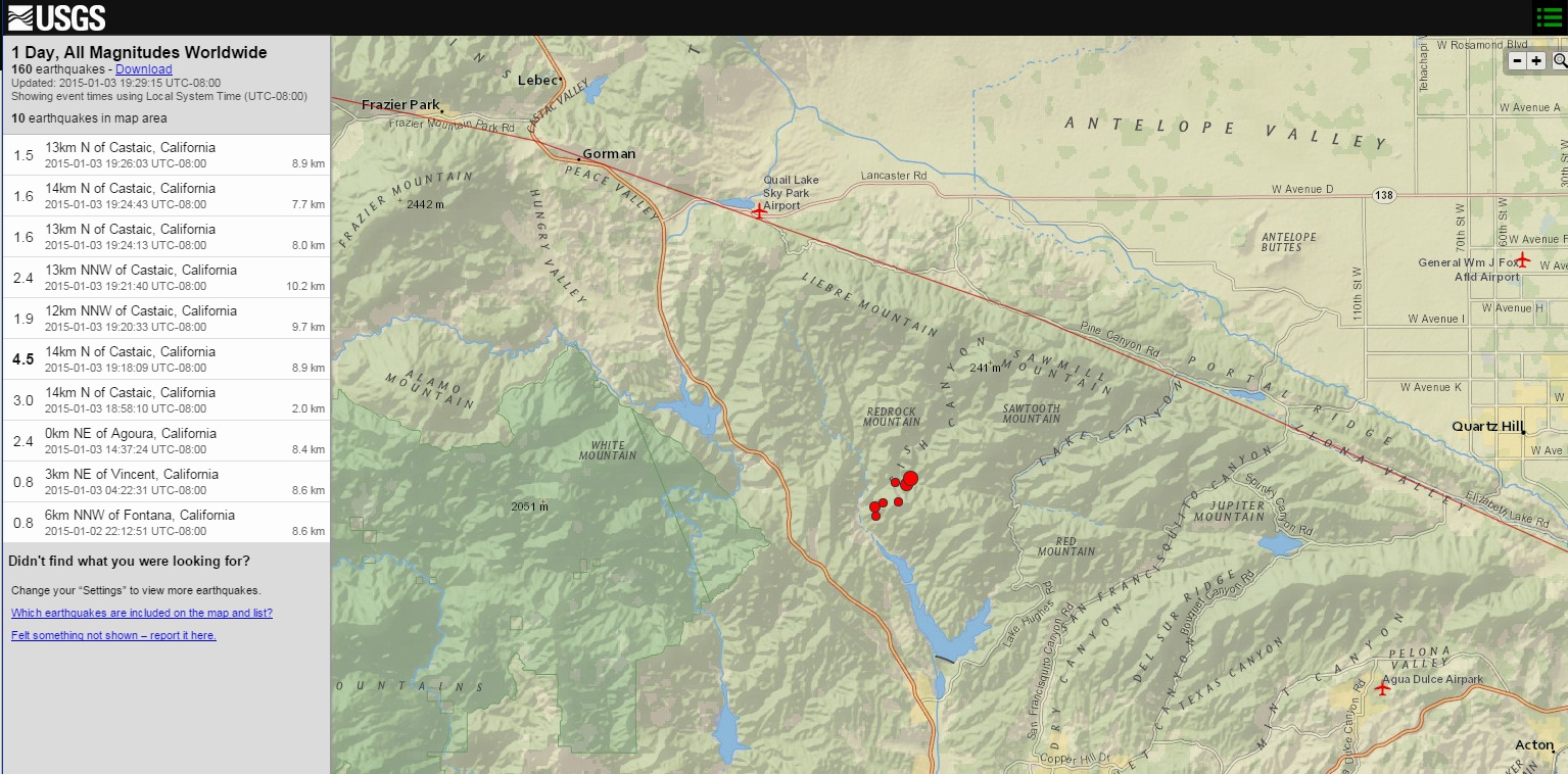
M4.5
14km N of Castaic, California
2015-01-04 03:18:09 UTC
Event Time
2015-01-04 03:18:09 UTC
2015-01-03 19:18:09 UTC-08:00 at epicenter
2015-01-03 19:18:09 UTC-08:00 system time
Location
34.620°N 118.630°W depth=8.9km (5.5mi)
Nearby Cities
14km (9mi) N of Castaic, California
26km (16mi) NNW of Santa Clarita, California
36km (22mi) NE of Fillmore, California
37km (23mi) W of Quartz Hill, California
508km (316mi) SSE of Sacramento, California
General Area
1.5
13km N of Castaic, California
2015-01-03 19:26:03 UTC-08:008.9 km
1.6
14km N of Castaic, California
2015-01-03 19:24:43 UTC-08:007.7 km
1.6
13km N of Castaic, California
2015-01-03 19:24:13 UTC-08:008.0 km
2.4
13km NNW of Castaic, California
2015-01-03 19:21:40 UTC-08:0010.2 km
1.9
12km NNW of Castaic, California
2015-01-03 19:20:33 UTC-08:009.7 km
4.5
14km N of Castaic, California
2015-01-03 19:18:09 UTC-08:008.9 km
3.0
14km N of Castaic, California
2015-01-03 18:58:10 UTC-08:002.0 km
2.4
0km NE of Agoura, California
2015-01-03 14:37:24 UTC-08:008.4 km
0.8
3km NE of Vincent, California
2015-01-03 04:22:31 UTC-08:008.6 km
0.8
6km NNW of Fontana, California
2015-01-02 22:12:51 UTC-08:008.6 km
files.abovetopsecret.com...
edit on 7/30/2012 by dreamfox1 because: files.abovetopsecret.com...
a reply to: muzzy
Glad to see you took up the cudgel Muzzy. I have been a bit out of it recently and anyway it sort of was your turn if we are doing year on year off as we seem to be.
Best wishes to eveyone for a prosperous 2015. May all earthquakes be little ones.
Glad to see you took up the cudgel Muzzy. I have been a bit out of it recently and anyway it sort of was your turn if we are doing year on year off as we seem to be.
Best wishes to eveyone for a prosperous 2015. May all earthquakes be little ones.
removed: Ooops could not get the right link
edit on 4/1/2015 by PuterMan because: (no reason given)
You won't see the 3rd Island much on the new NZEQ interactive map blog as the daily screenshot, not many quakes down on the south east side
normally.
Interesting 24 hrs though, also one off Dunedin and one off Christchurch too, something happening on the eastern side, perhaps something to do with those 2 x mag 5's down at the Pacific-Antarctic Ridge the last 2 days
(click image for interactive map, opens in new tab/window)
No visitors from ATS yet???
117 from elsewhere
Happy New Year all and thanks for keeping us informed.
Let us hope that all our shakes are small ones!
Let us hope that all our shakes are small ones!
102 earthquakes in Lakeview last 24 hours as of 10:45 pm US Central time
Largest ones:
3.9
78km ESE of Lakeview, Oregon
2015-01-04 03:56:43
10.2 km
3.9
71km ESE of Lakeview, Oregon
2015-01-04 14:08:14
6.8 km
3.7
70km ESE of Lakeview, Oregon
2015-01-04 19:47:22
7.4 km
3.4
70km ESE of Lakeview, Oregon
2015-01-04 00:03:43
7.2 km
3.3
64km ESE of Lakeview, Oregon
2015-01-04 03:28:37
11.7 km
3.2
68km ESE of Lakeview, Oregon
2015-01-04 02:32:33
8.1 km
3.1
66km ESE of Lakeview, Oregon
2015-01-04 01:03:21
4.1 km
40 minutes ago, heard it on the radio first.
Public ID 2015p012816
Intensity severe
Universal Time January 5 2015, 17:48:42
NZ Daylight Time Tue, Jan 6 2015, 6:48:42 am
Depth 10 km
Magnitude 6.4
Location Lake Coleridge, 35 km north of Methven
Latitude, Longitude -43.32, 171.59
Agency WEL(GNS_Primary)
www.geonet.org.nz...
aftershocks are further inland, 3 x 4mag and multiple 3's, Cascade Range in the Sthn. Alps
www.geonet.org.nz... (see larger map)
list here www.geonet.org.nz...
maybe those ones I mention yesterday coming in from the SE were indeed a warning something wasn't quite right.
Almost said last night before going to bed ........ "Full Moon", incoming, but couldn't see where, so didn't mention it.
edit on 01u4415 by
muzzy because: (no reason given)
downgraded by Useless SGS
M 5.6 - 45km NNW of Methven, New Zealand
Time
2015-01-05 11:48:41 UTC-06:00
Location
43.253°S 171.434°E
Depth
10.0km
M 5.6 - 45km NNW of Methven, New Zealand
Time
2015-01-05 11:48:41 UTC-06:00
Location
43.253°S 171.434°E
Depth
10.0km
a reply to: muzzy
Felt a slow and steady rocking in Christchurch, lampshades swinging, but no rumble so I thought it must have been a bit further afield than usual. Surprisingly friends in Darfield and Oxford didn't feel it. Wonder how the Coleridge Dam is?
I'm keeping my eye on the 'aftershocks' that are near the Alpine Fault west of Arthurs Pass, and more recently just near St Arnaud.....could be a busy year for some (what a statement! Sounds grand but doesn't mean much! ).
Canterbury Quake Live
Geonet
Anyway, stay safe, be prepared and carry on carrying on, wherever you are.
Oh yes, and a very Happy New Year to you all.
Felt a slow and steady rocking in Christchurch, lampshades swinging, but no rumble so I thought it must have been a bit further afield than usual. Surprisingly friends in Darfield and Oxford didn't feel it. Wonder how the Coleridge Dam is?
I'm keeping my eye on the 'aftershocks' that are near the Alpine Fault west of Arthurs Pass, and more recently just near St Arnaud.....could be a busy year for some (what a statement! Sounds grand but doesn't mean much! ).
Canterbury Quake Live
Geonet
Anyway, stay safe, be prepared and carry on carrying on, wherever you are.
edit on 5-1-2015 by aorAki because: Added links
Oh yes, and a very Happy New Year to you all.
edit on 5-1-2015 by aorAki because: (no reason given)
a reply to: muzzy
they had the location wrong, it was in where the aftershocks were, and downgraded to 6.0
Public ID 2015p012816
Intensity severe
Universal Time January 5 2015, 17:48:41
NZ Daylight Time Tue, Jan 6 2015, 6:48:41 am
Depth 5 km
Magnitude 6.0 (officially 5.9513)
Location Gibson Stream, 30 km west of Arthur's Pass
Latitude, Longitude -43.06, 171.25
Agency WEL(GNS_Primary)
Status reviewed
Quality best
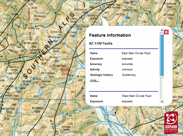
East Main Divide Fault (not listed as an active fault)
Movement type oblique slip
Dip direction angle 300
Dip angle 45
Down quadrant SE
Geologic history Quaternary
Activity age Q
Displacement total slip in the range 1-10 km
data.gns.cri.nz...
being officially 5.95 it shouldn't really get a Red Icon on my daily maps, but seeing as its damn close I'll give it the big orange reserved for significant over 5.6
they had the location wrong, it was in where the aftershocks were, and downgraded to 6.0
Public ID 2015p012816
Intensity severe
Universal Time January 5 2015, 17:48:41
NZ Daylight Time Tue, Jan 6 2015, 6:48:41 am
Depth 5 km
Magnitude 6.0 (officially 5.9513)
Location Gibson Stream, 30 km west of Arthur's Pass
Latitude, Longitude -43.06, 171.25
Agency WEL(GNS_Primary)
Status reviewed
Quality best
East Main Divide Fault (not listed as an active fault)
Movement type oblique slip
Dip direction angle 300
Dip angle 45
Down quadrant SE
Geologic history Quaternary
Activity age Q
Displacement total slip in the range 1-10 km
data.gns.cri.nz...
being officially 5.95 it shouldn't really get a Red Icon on my daily maps, but seeing as its damn close I'll give it the big orange reserved for significant over 5.6
edit on 010000004415 by muzzy because: (no reason given)
new topics
-
Why Files Our Alien Overlords | How We Secretly Serve The Tall Whites
Aliens and UFOs: 1 hours ago -
Curse of King Tuts Tomb Solved
Ancient & Lost Civilizations: 2 hours ago -
What allies does Trump have in the world?
ATS Skunk Works: 2 hours ago -
BIDEN Admin Begins Planning For January 2025 Transition to a New President - Today is 4.26.2024.
2024 Elections: 11 hours ago
top topics
-
James O’Keefe: I have evidence that exposes the CIA, and it’s on camera.
Whistle Blowers and Leaked Documents: 17 hours ago, 18 flags -
BIDEN Admin Begins Planning For January 2025 Transition to a New President - Today is 4.26.2024.
2024 Elections: 11 hours ago, 9 flags -
Big Storms
Fragile Earth: 12 hours ago, 8 flags -
Shocking Number of Voters are Open to Committing Election Fraud
US Political Madness: 16 hours ago, 7 flags -
Gov Kristi Noem Shot and Killed "Less Than Worthless Dog" and a 'Smelly Goat
2024 Elections: 16 hours ago, 6 flags -
Curse of King Tuts Tomb Solved
Ancient & Lost Civilizations: 2 hours ago, 6 flags -
Where should Trump hold his next rally
2024 Elections: 15 hours ago, 5 flags -
Falkville Robot-Man
Aliens and UFOs: 17 hours ago, 4 flags -
What allies does Trump have in the world?
ATS Skunk Works: 2 hours ago, 2 flags -
Why Files Our Alien Overlords | How We Secretly Serve The Tall Whites
Aliens and UFOs: 1 hours ago, 2 flags
active topics
-
Gaza Terrorists Attack US Humanitarian Pier During Construction
Middle East Issues • 101 • : FlyersFan -
University of Texas Instantly Shuts Down Anti Israel Protests
Education and Media • 326 • : Xtrozero -
BIDEN Admin Begins Planning For January 2025 Transition to a New President - Today is 4.26.2024.
2024 Elections • 23 • : Disgusted123 -
-@TH3WH17ERABB17- -Q- ---TIME TO SHOW THE WORLD--- -Part- --44--
Dissecting Disinformation • 708 • : Imbackbaby -
Falkville Robot-Man
Aliens and UFOs • 12 • : BeTheGoddess2 -
What allies does Trump have in the world?
ATS Skunk Works • 3 • : sine.nomine -
Why Files Our Alien Overlords | How We Secretly Serve The Tall Whites
Aliens and UFOs • 0 • : 727Sky -
James O’Keefe: I have evidence that exposes the CIA, and it’s on camera.
Whistle Blowers and Leaked Documents • 15 • : Scratchpost -
Starburst galaxy M82 - Webb Vs Hubble
Space Exploration • 12 • : gortex -
Is there a hole at the North Pole?
ATS Skunk Works • 42 • : seekshelter