It looks like you're using an Ad Blocker.
Please white-list or disable AboveTopSecret.com in your ad-blocking tool.
Thank you.
Some features of ATS will be disabled while you continue to use an ad-blocker.

Quake Watch 2015
page: 2share:
Public ID 2015p013541
Intensity severe
Universal Time January 6 2015, 0:14:24
NZ Daylight Time Tue, Jan 6 2015, 1:14:24 pm
Depth 5 km
Magnitude 5.0
Location 145 km south-west of Snares Islands
Latitude, Longitude -48.73, 164.94
Agency WEL(GNS_Secondary)
Status reviewed
Quality best
www.geonet.org.nz...
Intensity severe
Universal Time January 6 2015, 0:14:24
NZ Daylight Time Tue, Jan 6 2015, 1:14:24 pm
Depth 5 km
Magnitude 5.0
Location 145 km south-west of Snares Islands
Latitude, Longitude -48.73, 164.94
Agency WEL(GNS_Secondary)
Status reviewed
Quality best
www.geonet.org.nz...
link below is to map of the 5th UTC up till midnight, (Noon NZDT)
nzeq2015.blogspot.co.nz...
one foreshock 4 seconds prior, at Flat Hill 3.41km to the north on the other side of Eliot Ridge.
90 aftershocks to 14:40NZDT.
seem to be running both west and east, at right angles to the Fault shown on GNS's Geology Map
nzeq2015.blogspot.co.nz...
one foreshock 4 seconds prior, at Flat Hill 3.41km to the north on the other side of Eliot Ridge.
90 aftershocks to 14:40NZDT.
seem to be running both west and east, at right angles to the Fault shown on GNS's Geology Map
edit on 01u4415 by muzzy because: (no reason given)
NZ Topo maps are OK, but I miss the list that used to come with Google Maps.
Especially when it comes to aftershock series.
alternative here on ikimaps, i have to create the KMLfile at the right height above the ground and centre it to make it appear on the map as shown, you can't just load a standard NZ daily KML straight on. Last one on the list is the foreshock, I forgot to shift it to the top.
www.ikimap.com...
110 aftershocks now at nearly 12 hours.
rightclick"viewimage"forfullsize
edit on 010000005515 by muzzy because: (no reason given)
Well I warned yas Panama could be in trouble:
earthquake.usgs.gov...
6.6 just hit.
That's within 100 km of the other 6.6 that hit on December 8. Two 6.6's on a subduction zone spells bad news. Not good.
earthquake.usgs.gov...
6.6 just hit.
That's within 100 km of the other 6.6 that hit on December 8. Two 6.6's on a subduction zone spells bad news. Not good.
edit on Tue Jan 6th
2015 by TrueAmerican because: (no reason given)
further to: muzzy
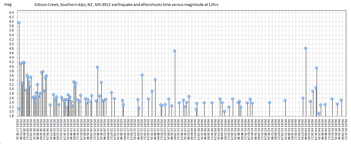
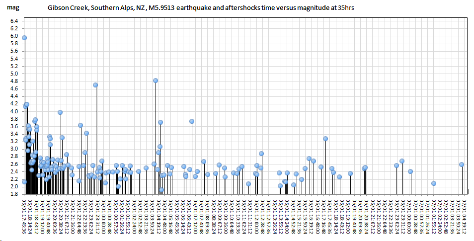
Gibson Creek, 5.9513 aftershocks
77 more aftershocks, mostly M2's, and easing ( longer between quakes), basically following the Gibson Stream (Valley) west to east towards Unknown Stream and Mt Findlay
06.01.2015 map
rightclick"viewimage"forfullsize
Gibson Creek, 5.9513 aftershocks
77 more aftershocks, mostly M2's, and easing ( longer between quakes), basically following the Gibson Stream (Valley) west to east towards Unknown Stream and Mt Findlay
06.01.2015 map
rightclick"viewimage"forfullsize
4.8, Tofino, Vancouver Island, 25 minutes ago.
edit on 7-1-2015 by AlexanderM because: (no reason given)
originally posted by: AlexanderM
4.8, Tofino, Vancouver Island, 25 minutes ago.
A few small ones around Vancouver Island these past few weeks. Better get those earthquake kits restocked.
a reply to: AlexanderM
and
a reply to: phoenixlights321
not sure where you got that number from
EQCAN say 4.6ML
GFZ are mb 5.0 but more NE inland and probably wrong
and
a reply to: phoenixlights321
not sure where you got that number from
EQCAN say 4.6ML
GFZ are mb 5.0 but more NE inland and probably wrong
originally posted by: muzzy
a reply to: AlexanderM
and
a reply to: phoenixlights321
not sure where you got that number from
EQCAN say 4.6ML
GFZ are mb 5.0 but more NE inland and probably wrong
earthquake.usgs.gov...
geofon has dropped their reading to 4.7mb (same link as above)
earthquake.usgs.gov...
M4.0
5km S of Guthrie, Oklahoma
2015-01-09 06:44:16 UTC
Event Time
2015-01-09 06:44:16 UTC
2015-01-09 00:44:16 UTC-06:00 at epicenter
2015-01-08 22:44:16 UTC-08:00 system time
Location
35.829°N 97.431°W depth=5.0km (3.1mi)
Nearby Cities
5km (3mi) S of Guthrie, Oklahoma
20km (12mi) NNE of Edmond, Oklahoma
38km (24mi) NNE of Bethany, Oklahoma
38km (24mi) NNE of Warr Acres, Oklahoma
40km (25mi) N of Oklahoma City, Oklahoma
a reply to: dreamfox1
Now its 3.5
Mwr
never heard of that one before, r must stand for "regional" as in
earthquake.usgs.gov...-tensor
what will they come up with next to dumb down the size of earthquakes to make it seem nothing much happened?
Now its 3.5
Mwr
never heard of that one before, r must stand for "regional" as in
Moment magnitude derived from a moment tensor inversion of complete waveforms at regional distances (less than ~8 degrees), generally used for the analysis of small to moderate size earthquakes (typically Mw 3.5-6.0) crust or upper mantle earthquakes.
earthquake.usgs.gov...-tensor
what will they come up with next to dumb down the size of earthquakes to make it seem nothing much happened?
Pac-Ant Ridge still doing its nut
2015 1 9 0 4 56.0 -54.50 -132.50 33.0 5.4 PACIFIC-ANTARCTIC RIDGE
2015 1 8 23 51 44.0 -54.50 -132.50 33.0 5.6 PACIFIC-ANTARCTIC RIDGE
www.ldeo.columbia.edu...
2015 1 9 0 4 56.0 -54.50 -132.50 33.0 5.4 PACIFIC-ANTARCTIC RIDGE
2015 1 8 23 51 44.0 -54.50 -132.50 33.0 5.6 PACIFIC-ANTARCTIC RIDGE
www.ldeo.columbia.edu...
edit on 010000008815 by muzzy because: (no reason given)
SWARM at Hawaii
earthquake.usgs.gov...
1.8
5km S of Volcano, Hawaii
2015-01-10 03:04:10 UTC-08:002.3 km
1.8
5km S of Volcano, Hawaii
2015-01-10 02:59:34 UTC-08:002.5 km
2.1
5km S of Volcano, Hawaii
2015-01-10 02:51:21 UTC-08:001.5 km
2.9
5km S of Volcano, Hawaii
2015-01-10 02:48:52 UTC-08:002.6 km
2.8
4km S of Volcano, Hawaii
2015-01-10 02:44:22 UTC-08:001.2 km
2.8
5km S of Volcano, Hawaii
2015-01-10 02:44:21 UTC-08:002.9 km
2.9
4km S of Volcano, Hawaii
2015-01-10 02:35:31 UTC-08:003.5 km
2.2
7km SSE of Volcano, Hawaii
2015-01-10 00:51:35 UTC-08:003.0 km
2.1
4km SSW of Volcano, Hawaii
2015-01-09 11:20:28 UTC-08:002.0 km
edit on 7/30/2012 by dreamfox1 because: (no reason given)
edit on 7/30/2012 by dreamfox1
because: (no reason given)
edit on 7/30/2012 by dreamfox1 because: (no reason given)
Luzon, Philippines 2hr 04min ago
Date/Time : 11 Jan 2015 - 03:31:59 AM
Location : 14.73°N, 119.76°E - 043 km S 55° W of San Antonio (Zambales)
Depth of Focus (Km) : 85
Magnitude : Ms 6.0
www.phivolcs.dost.gov.ph...
GFZ say 5.8Mw
but Russians are saying 6.2mb www.ceme.gsras.ru...
map (courtesy of GSRAS( new feature on their site, click the location text))
GSRAS list for 10th Jan so far
Date/Time : 11 Jan 2015 - 03:31:59 AM
Location : 14.73°N, 119.76°E - 043 km S 55° W of San Antonio (Zambales)
Depth of Focus (Km) : 85
Magnitude : Ms 6.0
www.phivolcs.dost.gov.ph...
GFZ say 5.8Mw
but Russians are saying 6.2mb www.ceme.gsras.ru...
Параметры землетрясения
date: 10-Янв-2015 19:31:58.3, lat: 14.73, lon: 120.32, depth: 60km, mb: 6.2/17
рассчитаны по станциям:
map (courtesy of GSRAS( new feature on their site, click the location text))
GSRAS list for 10th Jan so far
edit on 01u9915 by muzzy
because: add more opinions
further to: muzzy
I named it the Gibson Creek quake, but GNS have called it the Wilberforce River quake.
splitting hairs really, it was on Gibson Creek, which runs into the Wilberforce.
They are saying this one may be related to the 1994 6.7 quake across on the other side of the Wilberforce valley.
article from the Christchurch Press
www.stuff.co.nz...
seems to be a short 6 day aftershock series, was down to 4 x M2's yesterday.
edit on 01000000101015 by muzzy because: (no reason
given)
new topics
-
Las Vegas UFO Spotting Teen Traumatized by Demon Creature in Backyard
Aliens and UFOs: 1 minutes ago -
2024 Pigeon Forge Rod Run - On the Strip (Video made for you)
Automotive Discussion: 50 minutes ago -
Gaza Terrorists Attack US Humanitarian Pier During Construction
Middle East Issues: 1 hours ago -
The functionality of boldening and italics is clunky and no post char limit warning?
ATS Freshman's Forum: 2 hours ago -
Meadows, Giuliani Among 11 Indicted in Arizona in Latest 2020 Election Subversion Case
Mainstream News: 2 hours ago -
Massachusetts Drag Queen Leads Young Kids in Free Palestine Chant
Social Issues and Civil Unrest: 3 hours ago -
Weinstein's conviction overturned
Mainstream News: 4 hours ago -
Supreme Court Oral Arguments 4.25.2024 - Are PRESIDENTS IMMUNE From Later Being Prosecuted.
Above Politics: 6 hours ago -
Krystalnacht on today's most elite Universities?
Social Issues and Civil Unrest: 6 hours ago -
Chris Christie Wishes Death Upon Trump and Ramaswamy
Politicians & People: 6 hours ago
top topics
-
Krystalnacht on today's most elite Universities?
Social Issues and Civil Unrest: 6 hours ago, 8 flags -
Weinstein's conviction overturned
Mainstream News: 4 hours ago, 6 flags -
Supreme Court Oral Arguments 4.25.2024 - Are PRESIDENTS IMMUNE From Later Being Prosecuted.
Above Politics: 6 hours ago, 5 flags -
University of Texas Instantly Shuts Down Anti Israel Protests
Education and Media: 8 hours ago, 5 flags -
Massachusetts Drag Queen Leads Young Kids in Free Palestine Chant
Social Issues and Civil Unrest: 3 hours ago, 4 flags -
Meadows, Giuliani Among 11 Indicted in Arizona in Latest 2020 Election Subversion Case
Mainstream News: 2 hours ago, 4 flags -
Chris Christie Wishes Death Upon Trump and Ramaswamy
Politicians & People: 6 hours ago, 2 flags -
Any one suspicious of fever promotions events, major investor Goldman Sachs card only.
The Gray Area: 10 hours ago, 2 flags -
Gaza Terrorists Attack US Humanitarian Pier During Construction
Middle East Issues: 1 hours ago, 2 flags -
2024 Pigeon Forge Rod Run - On the Strip (Video made for you)
Automotive Discussion: 50 minutes ago, 1 flags
active topics
-
University of Texas Instantly Shuts Down Anti Israel Protests
Education and Media • 182 • : JAY1980 -
Las Vegas UFO Spotting Teen Traumatized by Demon Creature in Backyard
Aliens and UFOs • 0 • : FlyersFan -
Candidate TRUMP Now Has Crazy Judge JUAN MERCHAN After Him - The Stormy Daniels Hush-Money Case.
Political Conspiracies • 778 • : Annee -
Supreme Court Oral Arguments 4.25.2024 - Are PRESIDENTS IMMUNE From Later Being Prosecuted.
Above Politics • 59 • : xuenchen -
Breaking Baltimore, ship brings down bridge, mass casualties
Other Current Events • 489 • : Threadbarer -
-@TH3WH17ERABB17- -Q- ---TIME TO SHOW THE WORLD--- -Part- --44--
Dissecting Disinformation • 679 • : McTech2 -
Gaza Terrorists Attack US Humanitarian Pier During Construction
Middle East Issues • 15 • : Irishhaf -
Massachusetts Drag Queen Leads Young Kids in Free Palestine Chant
Social Issues and Civil Unrest • 9 • : theatreboy -
Meadows, Giuliani Among 11 Indicted in Arizona in Latest 2020 Election Subversion Case
Mainstream News • 5 • : Disgusted123 -
God's Righteousness is Greater than Our Wrath
Religion, Faith, And Theology • 29 • : Topcraft