It looks like you're using an Ad Blocker.
Please white-list or disable AboveTopSecret.com in your ad-blocking tool.
Thank you.
Some features of ATS will be disabled while you continue to use an ad-blocker.

Quake Watch 2015
page: 3share:
Is this normal for this area in the US?
www.foxnews.com...
www.foxnews.com...
HARTFORD, Conn. – The U.S. Geological Survey has confirmed a 3.3-magnitude earthquake near the Connecticut-Rhode Island state line.
Residents in Plainfield and Danielson in eastern Connecticut say a rumbling noise was heard shortly after 6:30 a.m. Monday.
The U.S. Geological Survey said areas affected by the earthquake Monday were Plainfield, Killingly and Norwich in Connecticut, and Coventry and Providence in Rhode Island
at the end of Dusky Sound, Fiordland
Public ID 2015p033746
Intensity moderate
Universal Time January 13 2015, 11:40:01
NZ Daylight Time Wed, Jan 14 2015, 12:40:01 am
Depth 78 km
Magnitude 5.5ML
Location 70 km west of Te Anau
Latitude, Longitude -45.69, 166.90
Agency WEL(GNS_Primary)
www.geonet.org.nz...
GFZ and UselesSGS are saying 4.8 on conversion to mb
1537 felt reports, that's quite a lot for the time of day and isolated location
was on the cards, TTNT dropped to 6 on the 11th
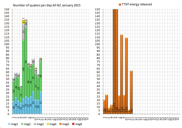
2nd M5 on land already for 2015, 4th if you include offshore (Sth of Kermadecs and Snares Is)
Public ID 2015p033746
Intensity moderate
Universal Time January 13 2015, 11:40:01
NZ Daylight Time Wed, Jan 14 2015, 12:40:01 am
Depth 78 km
Magnitude 5.5ML
Location 70 km west of Te Anau
Latitude, Longitude -45.69, 166.90
Agency WEL(GNS_Primary)
www.geonet.org.nz...
GFZ and UselesSGS are saying 4.8 on conversion to mb
1537 felt reports, that's quite a lot for the time of day and isolated location
was on the cards, TTNT dropped to 6 on the 11th
2nd M5 on land already for 2015, 4th if you include offshore (Sth of Kermadecs and Snares Is)
Could be nothing, but noteworthy. All 6 hours ago, within a 1/2 hour timeframe:
Weird- all 4.7 - 4.8 and in vastly different parts of the earth.
source: quakes.globalincidentmap.com
Tuesday January 13 2015, 11:40:01 UTC 6 hours ago South Island Of New Zealand 4.8 88.0 CSEM-EMSC Feed
Tuesday January 13 2015, 11:19:10 UTC 6 hours ago Southern Greece 4.7 72.0 CSEM-EMSC Feed
Tuesday January 13 2015, 11:16:27 UTC 6 hours ago Dominican Republic 4.8 2.0 CSEM-EMSC Feed
Weird- all 4.7 - 4.8 and in vastly different parts of the earth.
source: quakes.globalincidentmap.com
edit on 13/1/2015 by MarkJS because: (no reason given)
And again a trio of similar magnitude quakes, approx. 6.5 hours after the ones in the above post. All spread out over the globe. Noteworthy.
Note: Kermadec Islands are approx. 500 miles northeast of New Zealand in the Pacific. Wiki
Tuesday January 13 2015, 17:52:00 UTC 7 hours ago Iceland 4.7 9.0 CSEM-EMSC Feed
Tuesday January 13 2015, 17:47:16 UTC 7 hours ago Kermadec Islands Region 5.0 194.0 CSEM-EMSC Feed
Tuesday January 13 2015, 17:46:45 UTC 7 hours ago Eastern Honshu, Japan 4.8 60.0 CSEM-EMSC Feed
Note: Kermadec Islands are approx. 500 miles northeast of New Zealand in the Pacific. Wiki
a reply to: Vasa Croe
I am the nutter formally known as Radpetey
I changed my password and then forgot an old email address that they sent the new password to... Any hoooo!
This line of quakes looks pretty interesting
earthquake.usgs.gov... scale%22%2C%22autoUpdate%22%3Atrue%2C%22restrictListToMap%22%3Atrue%2C%22timeZone%22%3A%22local%22%2C%22mapposition%22%3A%5B%5B22.755920681486405%2C-2 32.47070312499997%5D%2C%5B49.92293545449574%2C-190.634765625%5D%5D%2C%22overlays%22%3A%7B%22plates%22%3Atrue%7D%2C%22viewModes%22%3A%7B%22list%22%3Atr ue%2C%22map%22%3Atrue%2C%22settings%22%3Afalse%2C%22help%22%3Afalse%7D%7D
Anyone concur??
a reply to: radpeteage
nothing but a white screen from that link at my end
that is why we call it UseleSGS
since they "improved" their web site it has been user unfriendly
nothing but a white screen from that link at my end
that is why we call it UseleSGS
since they "improved" their web site it has been user unfriendly
was at 5 minds which NZ quake area to pick for todays screenshot (13Jan UTC).
Had the early 00:40 NZDT M5.5 at Dusky Sound, with what could be a foreshock and 3 aftershocks further north at the end of Doubtful Sound, but nothing close by the 5.5,
or
a 4.1 later @ 6:11am NZDT Mt Dagg on the other side of the Tararua Mts behind where I live, with a 3.1 and 5 x M1 aftershocks,
or
the Wilberforce River/Southern Alps/Unknown Stream aftershocks of the 5.95 seem to have picked up again, 3.3, 3.1 and 3 x M2's
or
the lingering Cook Strait (July/Aug 2013)(9 events ,M2's and M1's) or the lingering Eketahuna (Jan 2014) (6 x M1's) aftershocks
busy day all round
worth a look
nzeq2015.blogspot.co.nz...
only place missing activity is ....................
Christchurch
(hope I don't put a hex on it by mentioning)
in the end I went for the M5.5
originally posted by: muzzy
a reply to: radpeteage
nothing but a white screen from that link at my end
that is why we call it UseleSGS
since they "improved" their web site it has been user unfriendly
Hey muzzy!
It was the 4 upper 4 mag quakes east of Japan, quite evenly spaced...and all just west of the subduction line.
a reply to: radpeteage
oh OK
too late to see it now, UselesSGS only have 1 day or 7 days quakes, nothing in between
Had a look at Wilber3, which is searchable
I see 3 @ over M4.7, those must be them eh
ds.iris.edu...
oh OK
too late to see it now, UselesSGS only have 1 day or 7 days quakes, nothing in between
Had a look at Wilber3, which is searchable
I see 3 @ over M4.7, those must be them eh
ds.iris.edu...
edit on 01u131315 by muzzy because: (no reason given)
Swarm of earthquakes at Steaming Cliff, Lake Rotomahana, NI,NZ
8 x M2's
10 x M1's
Thermal area. en.wikipedia.org...
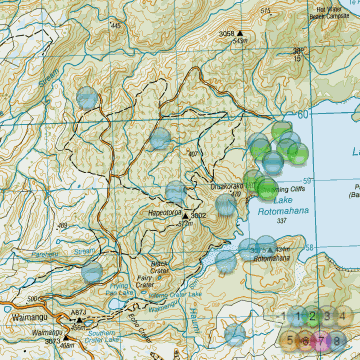
NZ 14.01.2015 UTC interactive map
8 x M2's
10 x M1's
Thermal area. en.wikipedia.org...
NZ 14.01.2015 UTC interactive map
edit on 01000000141415 by muzzy because:
tired made a few mistakes, fixed em
3.8 located in the middle of the Gulf of St-Lawrence
I wonder if this is linked to the Connecticut swarm.
Event Time
2015-01-16 13:05:25 UTC
2015-01-16 09:05:25 UTC-04:00 at epicenter
2015-01-16 08:05:25 UTC-05:00 system time
Location
49.541°N 66.707°W depth=10.0km (6.2mi)
Nearby Cities
48km (30mi) NNW of Sainte-Anne-des-Monts, Canada
76km (47mi) SSW of Sept-Iles, Canada
99km (62mi) NE of Matane, Canada
110km (68mi) ENE of Baie-Comeau, Canada
399km (248mi) N of Fredericton, Canada
edit on 16-1-2015 by aboutface because: (no reason given)
I see some authoritative type ATS person called DontTreadOnMe posted on Jan, 4 2015 @ 09:07 PM
well DTOM, a to you for doing so!
If you actually bothered to follow these Quake Watch threads you would have noticed over the years that the end of the year is followed by summaries of various countries final figures for the year. It often takes a bit of time to gather up the data to do so, in some cases it may be months to get some of the information.
How can that be done when you closed the thread to posting on?
Dumb
closing this one.....
well DTOM, a to you for doing so!
If you actually bothered to follow these Quake Watch threads you would have noticed over the years that the end of the year is followed by summaries of various countries final figures for the year. It often takes a bit of time to gather up the data to do so, in some cases it may be months to get some of the information.
How can that be done when you closed the thread to posting on?
Dumb
a reply to: pheonix358
why should I waste my time,
its their mistake.
asking for anything on this site is like talking to N. Korea
why should I waste my time,
its their mistake.
asking for anything on this site is like talking to N. Korea
Public ID: 2015p041667
Date/Time NZDT: 16/01/2015 23:00:16
Date/Time UTC: 16/01/2015 10:00:16:
Latitude, Longitude: 41.07°S, 174.34°E
Location: - Queen Charlotte Sound, Marlborough [GL16321]
Depth: 63 Km
Magnitude: 4.0286ML
map and 1334 felt reports
Not far from me but I didn't feel it, I was asleep at the time
edit on 01000000151515 by muzzy because: (no reason given)
earthquake.usgs.gov...
M4.1 - 16km E of Cherokee, Oklahoma
2015-01-19 10:19:20 UTC
Event Time
2015-01-19 10:19:20 UTC
2015-01-19 04:19:20 UTC-06:00 at epicenter
2015-01-19 02:19:20 UTC-08:00 system time
Location
36.765°N 98.177°W depth=7.3km (4.5mi)
Nearby Cities
16km (10mi) E of Cherokee, Oklahoma
48km (30mi) NNW of Enid, Oklahoma
97km (60mi) W of Ponca City, Oklahoma
106km (66mi) WSW of Arkansas City, Kansas
155km (96mi) NNW of Oklahoma City, Oklah
earthquake.usgs.gov...
M3.0 - 19km SE of Fountain, Colorado
2015-01-19 09:56:20 UTC
Event Time
2015-01-19 09:56:20 UTC
2015-01-19 02:56:20 UTC-07:00 at epicenter
2015-01-19 01:56:20 UTC-08:00 system time
Location
38.537°N 104.570°W depth=5.0km (3.1mi)
Nearby Cities
19km (12mi) SE of Fountain, Colorado
24km (15mi) NNE of Pueblo West, Colorado
26km (16mi) SSE of Security-Widefield, Colorado
29km (18mi) SE of Fort Carson, Colorado
138km (86mi) SSE of Denver, Colorado
earthquake.usgs.gov...
M3.9 - 13km ENE of Anthony, Kansas
2015-01-19 09:54:31 UTC
Event Time
2015-01-19 09:54:31 UTC
2015-01-19 03:54:31 UTC-06:00 at epicenter
2015-01-19 01:54:31 UTC-08:00 system time
Location
37.188°N 97.885°W depth=5.0km (3.1mi)
Nearby Cities
13km (8mi) ENE of Anthony, Kansas
62km (39mi) SW of Haysville, Kansas
67km (42mi) SW of Derby, Kansas
73km (45mi) SW of Wichita, Kansas
193km (120mi) N of Oklahoma City, Oklahoma
edit on 7/30/2012 by dreamfox1 because: (no reason given)
Time, Mag, Lat, Long, Depth, Location
2015-01-19 15:05:49 , 4.8 , 73.27°N , 6.49°E , 10, Greenland Sea
2015-01-19 13:09:37 , 4.7 , 73.27°N , 6.57°E , 10, Greenland Sea
2015-01-19 12:45:13 , 5.4 , 73.27°N , 6.47°E , 10 , Greenland Sea
2015-01-19 12:31:51 , 5.1 , 73.34°N , 6.56°E , 10, Greenland Sea
2015-01-19 06:38:40 , 4.2 , 73.49°N , 5.96°E , 10, Greenland Sea
2015-01-19 06:31:15 , 4.4 , 73.34°N , 6.31°E , 10, Greenland Sea
geofon.gfz-potsdam.de...
new topics
-
Big Storms
Fragile Earth: 1 hours ago -
Where should Trump hold his next rally
2024 Elections: 3 hours ago -
Shocking Number of Voters are Open to Committing Election Fraud
US Political Madness: 4 hours ago -
Gov Kristi Noem Shot and Killed "Less Than Worthless Dog" and a 'Smelly Goat
2024 Elections: 5 hours ago -
Falkville Robot-Man
Aliens and UFOs: 5 hours ago -
James O’Keefe: I have evidence that exposes the CIA, and it’s on camera.
Whistle Blowers and Leaked Documents: 6 hours ago -
Australian PM says the quiet part out loud - "free speech is a threat to democratic dicourse"...?!
New World Order: 7 hours ago -
Ireland VS Globalists
Social Issues and Civil Unrest: 7 hours ago -
Biden "Happy To Debate Trump"
2024 Elections: 8 hours ago -
RAAF airbase in Roswell, New Mexico is on fire
Aliens and UFOs: 8 hours ago
top topics
-
A Warning to America: 25 Ways the US is Being Destroyed
New World Order: 17 hours ago, 21 flags -
Blast from the past: ATS Review Podcast, 2006: With All Three Amigos
Member PODcasts: 10 hours ago, 13 flags -
James O’Keefe: I have evidence that exposes the CIA, and it’s on camera.
Whistle Blowers and Leaked Documents: 6 hours ago, 13 flags -
Biden "Happy To Debate Trump"
2024 Elections: 8 hours ago, 12 flags -
Australian PM says the quiet part out loud - "free speech is a threat to democratic dicourse"...?!
New World Order: 7 hours ago, 12 flags -
Mike Pinder The Moody Blues R.I.P.
Music: 10 hours ago, 8 flags -
What is the white pill?
Philosophy and Metaphysics: 9 hours ago, 6 flags -
Shocking Number of Voters are Open to Committing Election Fraud
US Political Madness: 4 hours ago, 5 flags -
Ireland VS Globalists
Social Issues and Civil Unrest: 7 hours ago, 5 flags -
RAAF airbase in Roswell, New Mexico is on fire
Aliens and UFOs: 8 hours ago, 5 flags
active topics
-
President BIDEN Vows to Make Americans Pay More Federal Taxes in 2025 - Political Suicide.
2024 Elections • 146 • : Zanti Misfit -
Definitive 9.11 Pentagon EVIDENCE.
9/11 Conspiracies • 427 • : Zanti Misfit -
So this is what Hamas considers 'freedom fighting' ...
War On Terrorism • 266 • : ToneD -
Big Storms
Fragile Earth • 8 • : charlest2 -
SHORT STORY WRITERS CONTEST -- April 2024 -- TIME -- TIME2024
Short Stories • 24 • : argentus -
Gov Kristi Noem Shot and Killed "Less Than Worthless Dog" and a 'Smelly Goat
2024 Elections • 35 • : nugget1 -
Ireland VS Globalists
Social Issues and Civil Unrest • 7 • : boatguy12 -
"We're All Hamas" Heard at Columbia University Protests
Social Issues and Civil Unrest • 292 • : TheWoker -
I am beholden to my truth, of which I share with you now.
Dreams & Predictions • 24 • : BrotherKinsMan -
Starburst galaxy M82 - Webb Vs Hubble
Space Exploration • 11 • : Arbitrageur