It looks like you're using an Ad Blocker.
Please white-list or disable AboveTopSecret.com in your ad-blocking tool.
Thank you.
Some features of ATS will be disabled while you continue to use an ad-blocker.

Quake Watch 2015
page: 24share:
a reply to: crappiekat
No problem, just glad some other people share my interest too. i'm a bit obsessed with japan right now, which isn't of interest to everyone
I had a look at Kilauea after you mentioned it, some nice links by Olivine there too
I must say from casual observance that these quakes seem quite high in magnitude for there.
That Debris Landslide sounds scary, could be a M9 and mega-tsunami if it all went at once, glad I live of the West Caost of NZ and not the East. Sounds like the shelf that has formed there might stop/reduce a major collapse.
I should really make an effort to get up there, have only been to Ohau a couple of times, never to the Big Island. Its been active since I have been alive.
a reply to: ressiv
Level 2 Near-crater warning (Do not approach the crater) Hakoneyama 06:00 JST, 06 May 2015
www.jma.go.jp...
www.jma.go.jp...
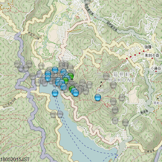
I'm assuming the "crater" is Lake Ashi
I haven't really studied the detailed layout yet
maybe this should go to Volcano Watch? but at this stage its just earthquakes, there is no reports of volcanic activity
here is the latest map, 95 events, mag~1=69, mag1=26
Level 2 Near-crater warning (Do not approach the crater) Hakoneyama 06:00 JST, 06 May 2015
www.jma.go.jp...
www.jma.go.jp...
I'm assuming the "crater" is Lake Ashi
I haven't really studied the detailed layout yet
edit on 05u13613615 by muzzy because: add 2nd link
maybe this should go to Volcano Watch? but at this stage its just earthquakes, there is no reports of volcanic activity
here is the latest map, 95 events, mag~1=69, mag1=26
edit on 0500000013613615 by muzzy because: (no reason given)
M5.8 - 151km SW of Panguna, Papua New Guinea
7.157°S 154.400°E depth=8.1 km (5.0 mi)
Time
2015-05-18 17:04:52 (UTC)
2015-05-18 12:04:52 (UTC-05:00) in your timezone
Times in other timezones
Nearby Cities
151km (94mi) SW of Panguna, Papua New Guinea
163km (101mi) SW of Arawa, Papua New Guinea
390km (242mi) SE of Kokopo, Papua New Guinea
503km (313mi) ESE of Kimbe, Papua New Guinea
661km (411mi) WNW of Honiara, Solomon Islands
USGS
On a side note frackalackin continues.
3.3
5km SSW of Farmers Branch, Texas
2015-05-18 13:14:29 UTC-05:005.0 km
3.1
33km WNW of Fort Stockton, Texas
2015-05-17 17:15:14 UTC-05:005.0 km
edit on 18-5-2015 by lurksoften because: (no reason given)
If anyone who has the capability to run frequency analysis on the audio in this
post and see if there is any seismic component to the sound, it would be most appreciated; presuming the recording quality is sufficient.
edit on 18-5-2015 by jadedANDcynical because: (no reason given)
M3.1 - 38km ENE of Old Faithful Geyser, Wyoming
Depth: 3.4 km
Nearby Cities
38km (24mi) ENE of Old Faithful Geyser, Wyoming
133km (83mi) SSE of Bozeman, Montana
140km (87mi) NE of Rexburg, Idaho
177km (110mi) NE of Ammon, Idaho
258km (160mi) SSE of Helena, Montana
earthquake.usgs.gov...
Yellowstone......
Depth: 3.4 km
Nearby Cities
38km (24mi) ENE of Old Faithful Geyser, Wyoming
133km (83mi) SSE of Bozeman, Montana
140km (87mi) NE of Rexburg, Idaho
177km (110mi) NE of Ammon, Idaho
258km (160mi) SSE of Helena, Montana
earthquake.usgs.gov...
Yellowstone......
edit on 18-5-2015 by Darkblade71 because: (no reason given)
a reply to: Darkblade71
Glad you posted this one!
I checked over on the Yellowstone thread.
I thought someone would have mentioned it there by now.
But it's deader than doornails there too!
WOQ
I did find this map:
www.seis.utah.edu...
Glad you posted this one!
I checked over on the Yellowstone thread.
I thought someone would have mentioned it there by now.
But it's deader than doornails there too!
WOQ
I did find this map:
www.seis.utah.edu...
edit on 18-5-2015 by wasobservingquietly because: (no reason
given)
a reply to: Olivine
Read this interesting Article also. Looks like there could be more to those earthquakes.
Source
Read this interesting Article also. Looks like there could be more to those earthquakes.
Kilauea Earthquakes Could Be Warning of New Eruption, Scientists Say
It's nothing new to see one of the world's most active volcanoes spewing lava, but when the ground shifts and multiple earthquakes occur, scientists begin to pay a little more attention.
That's been happening at Hawaii's Kilauea volcano. As many as 20 to 25 earthquakes have been reported in a single hour, and scientists' tilt meters showed the ground was deforming.
At the same time, a lava lake near the Big Island summit rose to a record-high level. Then, the surface of the lava lake dipped nearly 500 feet, and experts are now working to figure out why this happened.
"Clearly the lava, by dropping out of sight, it has to be going somewhere," said Steven Brantley, deputy scientist in charge of Hawaiian Volcano Observatory of the U.S. Geological Survey.
The flurry of earthquakes that peaked in intensity Friday have been rattling Kilauea's southwest rift zone, so it's possible that a new eruption could occur southwest of the Halemaumau Crater, or even in the crater itself, Brentley said. Or, the tilting, shifting ground could lead to nothing.
"We don't know what the outcome of this activity might be," Brantley said. "That is the challenge, is trying to interpret what this activity really means in terms of the next step for Kilauea."
Source
M5.8 - 98km S of Port-Vila, Vanuatu
18.608°S 168.505°E depth=50.7 km (31.5 mi)
Time
2015-05-19 13:54:56 (UTC)
2015-05-19 08:54:56 (UTC-05:00) in your timezone
Times in other timezones
Nearby Cities
98km (61mi) S of Port-Vila, Vanuatu
286km (178mi) NNE of We, New Caledonia
368km (229mi) SSE of Luganville, Vanuatu
446km (277mi) NNE of Dumbea, New Caledonia
98km (61mi) S of Port-Vila, Vanuatu
USGS
M6.5 - Pacific-Antarctic Ridge
54.301°S 132.110°W depth=12.1 km (7.5 mi)
Time
2015-05-19 15:25:21 (UTC)
2015-05-19 10:25:21 (UTC-05:00) in your timezone
Times in other timezones
Nearby Cities
2151km (1337mi) N of Siple, Mount, Antarctica
3891km (2418mi) WSW of Puerto Natales, Chile
3912km (2431mi) WSW of Punta Arenas, Chile
3983km (2475mi) WSW of Ushuaia, Argentina
3250km (2019mi) S of Adamstown, Pitcairn
USGS
earthquake.usgs.gov...
This is an interesting one.
earthquake.usgs.gov...
OK not sure what I am doing wrong now.
ctl +C copy
ctl + V paste
Anyway, until I fix that.
6.5 Pacific Antarctic Ridge.
This is an interesting one.
earthquake.usgs.gov...
edit on 19-5-2015 by crappiekat because: fixing link
OK not sure what I am doing wrong now.
ctl +C copy
ctl + V paste
Anyway, until I fix that.
6.5 Pacific Antarctic Ridge.
edit on 19-5-2015 by crappiekat because: (no reason given)
originally posted by: crappiekat
earthquake.usgs.gov...
This is an interesting one.
Hey Crappiek, your image is of plates, no quake or map?
Also, reports a strong earthquake in Kathmandu, no details yet?
EMSC
edit on 5/19/2015 by whatnext21 because: (no reason given)
Seems to have been removed from the banner that runs when something that is felt is reported?
edit on 5/19/2015 by whatnext21 because: (no
reason given)
a reply to: whatnext21
earthquake.usgs.gov...
Ok think I may have it this time.
Sorry for the mess you guys.
earthquake.usgs.gov...
Ok think I may have it this time.
Sorry for the mess you guys.
a reply to: whatnext21
Well CERI is down for me.
I was checking to see if that 6.5 may be ringing bells all over. so maybe they were looking at the helicorders and saw the 6.5
Well CERI is down for me.
I was checking to see if that 6.5 may be ringing bells all over. so maybe they were looking at the helicorders and saw the 6.5
M4.0 - 39km ESE of Ridgemark, California
Time
2015-05-19 18:36:02 (UTC)
Nearby Cities
40km (25mi) SSW of South Dos Palos, California
44km (27mi) S of Los Banos, California
46km (29mi) NE of Soledad, California
47km (29mi) WSW of Mendota, California
219km (136mi) SSE of Sacramento, California
earthquake.usgs.gov...
A little stronger than the norm...
M6.9 - 177km W of Lata, Solomon Islands
2015-05-20 22:48:53 (UTC)
Nearby Cities
177km (110mi) W of Lata, Solomon Islands
491km (305mi) ESE of Honiara, Solomon Islands
612km (380mi) NNW of Luganville, Vanuatu
884km (549mi) NNW of Port-Vila, Vanuatu
1082km (672mi) ESE of Arawa, Papua New Guinea
earthquake.usgs.gov...
2015-05-20 22:48:53 (UTC)
Nearby Cities
177km (110mi) W of Lata, Solomon Islands
491km (305mi) ESE of Honiara, Solomon Islands
612km (380mi) NNW of Luganville, Vanuatu
884km (549mi) NNW of Port-Vila, Vanuatu
1082km (672mi) ESE of Arawa, Papua New Guinea
earthquake.usgs.gov...
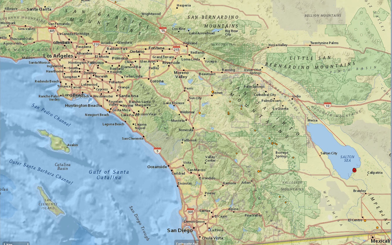
Big shaker may be heading our way soon here in California.....!
earthquake.usgs.gov...
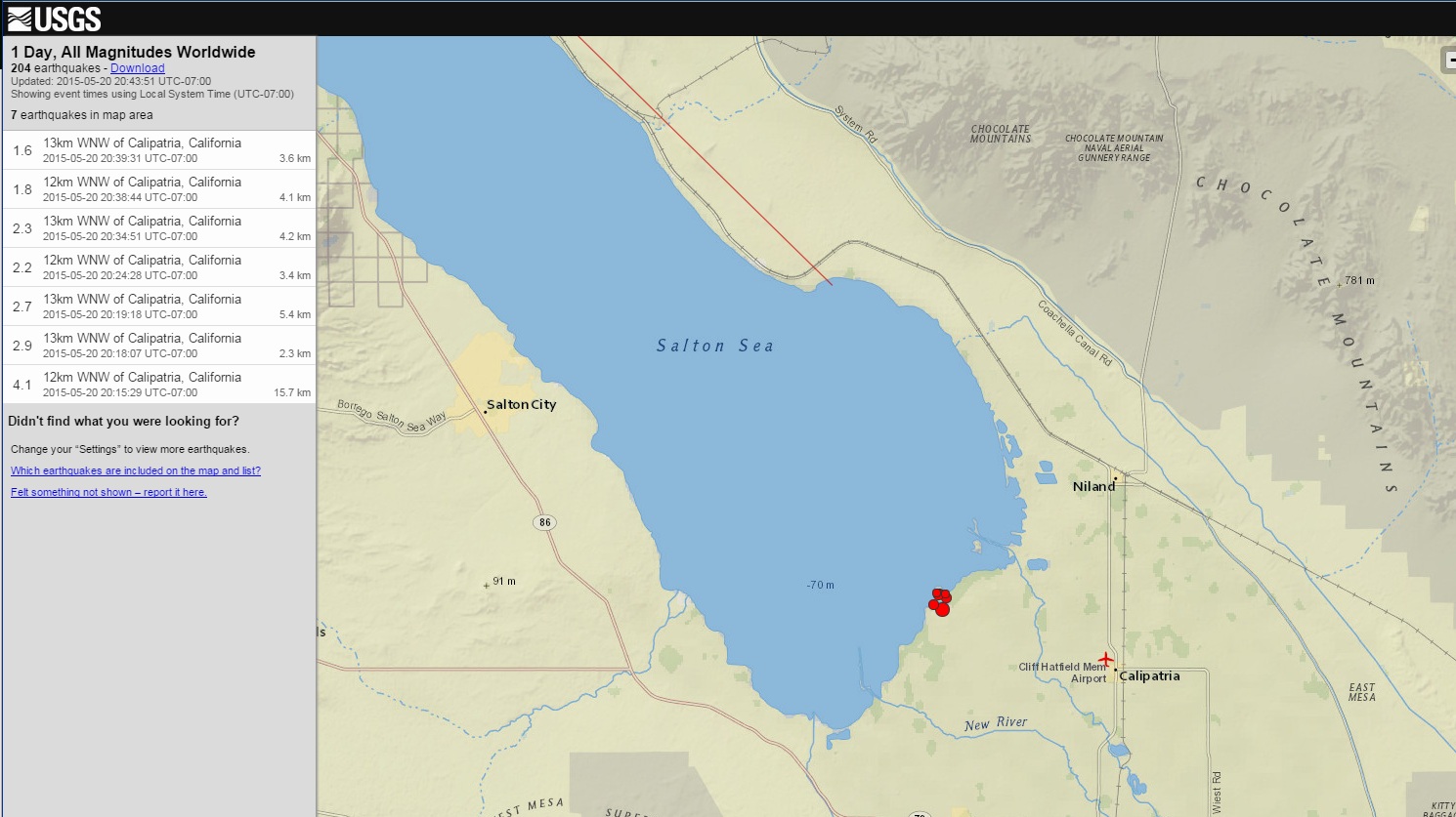
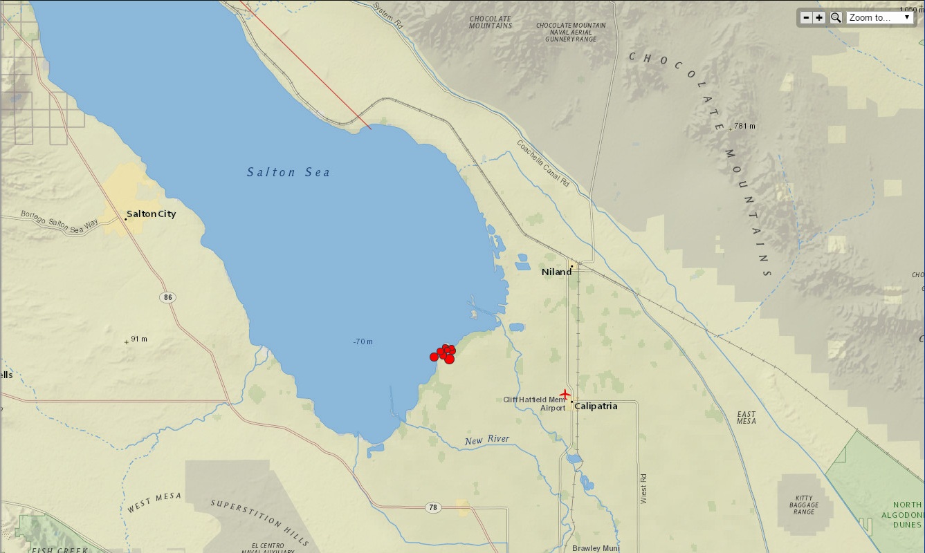
M4.1 - 12km WNW of Calipatria, California
Time
2015-05-21 03:15:29 (UTC)
2015-05-20 20:15:29 (UTC-07:00) in your timezone
Times in other timezones
Nearby Cities
12km (7mi) WNW of Calipatria, California
14km (9mi) N of Westmorland, California
14km (9mi) SW of Niland, California
42km (26mi) N of El Centro, California
59km (37mi) NNW of Mexicali, B.C., MX
111km (69mi) SE of Palm Springs, California
1.8
12km WNW of Calipatria, California
2015-05-20 20:53:44 UTC-07:003.3 km
2.6
13km WNW of Calipatria, California
2015-05-20 20:52:23 UTC-07:003.2 km
3.3
13km WNW of Calipatria, California
2015-05-20 20:51:02 UTC-07:002.3 km
1.6
13km WNW of Calipatria, California
2015-05-20 20:39:31 UTC-07:003.6 km
1.8
13km WNW of Calipatria, California
2015-05-20 20:38:44 UTC-07:002.1 km
2.3
13km WNW of Calipatria, California
2015-05-20 20:34:51 UTC-07:004.2 km
2.2
12km WNW of Calipatria, California
2015-05-20 20:24:28 UTC-07:003.4 km
2.7
13km WNW of Calipatria, California
2015-05-20 20:19:18 UTC-07:005.4 km
2.9
13km WNW of Calipatria, California
2015-05-20 20:18:07 UTC-07:002.3 km
4.1
12km WNW of Calipatria, California
2015-05-20 20:15:29 UTC-07:0015.7 km
earthquake.usgs.gov...
M4.1 - 12km WNW of Calipatria, California
Time
2015-05-21 03:15:29 (UTC)
2015-05-20 20:15:29 (UTC-07:00) in your timezone
Times in other timezones
Nearby Cities
12km (7mi) WNW of Calipatria, California
14km (9mi) N of Westmorland, California
14km (9mi) SW of Niland, California
42km (26mi) N of El Centro, California
59km (37mi) NNW of Mexicali, B.C., MX
111km (69mi) SE of Palm Springs, California
1.8
12km WNW of Calipatria, California
2015-05-20 20:53:44 UTC-07:003.3 km
2.6
13km WNW of Calipatria, California
2015-05-20 20:52:23 UTC-07:003.2 km
3.3
13km WNW of Calipatria, California
2015-05-20 20:51:02 UTC-07:002.3 km
1.6
13km WNW of Calipatria, California
2015-05-20 20:39:31 UTC-07:003.6 km
1.8
13km WNW of Calipatria, California
2015-05-20 20:38:44 UTC-07:002.1 km
2.3
13km WNW of Calipatria, California
2015-05-20 20:34:51 UTC-07:004.2 km
2.2
12km WNW of Calipatria, California
2015-05-20 20:24:28 UTC-07:003.4 km
2.7
13km WNW of Calipatria, California
2015-05-20 20:19:18 UTC-07:005.4 km
2.9
13km WNW of Calipatria, California
2015-05-20 20:18:07 UTC-07:002.3 km
4.1
12km WNW of Calipatria, California
2015-05-20 20:15:29 UTC-07:0015.7 km
edit on 7/30/2012 by dreamfox1 because: (no reason given)
edit on 7/30/2012 by dreamfox1
because: (no reason given)
edit on 7/30/2012 by dreamfox1 because: (no reason given)
files.abovetopsecret.com...
files.abovetopsecret.com...
files.abovetopsecret.com...
edit on 7/30/2012 by dreamfox1 because: (no reason given)
Got a bit behind on Japan, 3 days out. Just loaded 526 new earthquakes.
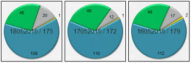
link for those not logged in
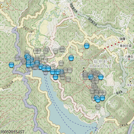
Hakone still popping, 97 events of the 18th JST, 3 of them M2's, still nestling at the north end of Lake Ashi.
Seems to have eased off on the 19th, only 39 events.
Had a few issues with Sync. for Dropbox this week, KML files hadn't loaded for NZ so the maps were blank, I didn't notice as I don't usually check. Had to load using the Dropbox website, takes forever. Have fixed it I think, reboot required. Damn Vista, looking forward to getting My W8 laptop back soon. Never thought I would say that, I hated W8 when it first came out.
link for those not logged in
Hakone still popping, 97 events of the 18th JST, 3 of them M2's, still nestling at the north end of Lake Ashi.
Seems to have eased off on the 19th, only 39 events.
Had a few issues with Sync. for Dropbox this week, KML files hadn't loaded for NZ so the maps were blank, I didn't notice as I don't usually check. Had to load using the Dropbox website, takes forever. Have fixed it I think, reboot required. Damn Vista, looking forward to getting My W8 laptop back soon. Never thought I would say that, I hated W8 when it first came out.
a reply to: dreamfox1
funny you seen that, I was looking at my old Firefox favorites this morning, as I have switched over to Chrome and need to reload all the earthquake links,
SCEDC Caltech was one I thought "hmmm need to reload that one".
I see they are still doing the old style maps and lists, good on them .
scedc.caltech.edu...
scedc.caltech.edu...]
Calipatria? neverheardofit (until I seen your maps)
Obsidian Butte? ohyeah, Salton Sea area
It has been a while since a M5+ in S. California, last one was Brawley in 2012 wan't it?
I still have the link
www.scsn.org...
Oh no, it was La Habra Aug 2014, my mistake
www.scsn.org...
and of course before Brawley was the April 4th 2010 Guadalupe Victoria, Baja 7.2Mw quake, with possibly the most prodigious aftershock seqences ever seen on ATS, some 20,000 of them
www.scsn.org...
funny you seen that, I was looking at my old Firefox favorites this morning, as I have switched over to Chrome and need to reload all the earthquake links,
SCEDC Caltech was one I thought "hmmm need to reload that one".
I see they are still doing the old style maps and lists, good on them .
scedc.caltech.edu...
scedc.caltech.edu...]
Calipatria? neverheardofit (until I seen your maps)
Obsidian Butte? ohyeah, Salton Sea area
It has been a while since a M5+ in S. California,
I still have the link
www.scsn.org...
Oh no, it was La Habra Aug 2014, my mistake
www.scsn.org...
and of course before Brawley was the April 4th 2010 Guadalupe Victoria, Baja 7.2Mw quake, with possibly the most prodigious aftershock seqences ever seen on ATS, some 20,000 of them
www.scsn.org...
edit on 0500000014014015 by muzzy because: (no reason given)
edit on 05u14014015 by
muzzy because: (no reason given)
new topics
-
Is the origin for the Eye of Horus the pineal gland?
General Conspiracies: 1 hours ago -
Man sets himself on fire outside Donald Trump trial
Mainstream News: 1 hours ago -
Biden says little kids flip him the bird all the time.
2024 Elections: 1 hours ago -
The Democrats Take Control the House - Look what happened while you were sleeping
US Political Madness: 1 hours ago -
Sheetz facing racial discrimination lawsuit for considering criminal history in hiring
Social Issues and Civil Unrest: 1 hours ago -
In an Historic First, In N Out Burger Permanently Closes a Location
Mainstream News: 3 hours ago -
MH370 Again....
Disaster Conspiracies: 4 hours ago -
Are you ready for the return of Jesus Christ? Have you been cleansed by His blood?
Religion, Faith, And Theology: 6 hours ago -
Chronological time line of open source information
History: 8 hours ago -
A man of the people
Diseases and Pandemics: 9 hours ago
top topics
-
In an Historic First, In N Out Burger Permanently Closes a Location
Mainstream News: 3 hours ago, 14 flags -
The Democrats Take Control the House - Look what happened while you were sleeping
US Political Madness: 1 hours ago, 8 flags -
Thousands Of Young Ukrainian Men Trying To Flee The Country To Avoid Conscription And The War
Other Current Events: 14 hours ago, 7 flags -
Iran launches Retalliation Strike 4.18.24
World War Three: 17 hours ago, 6 flags -
A man of the people
Diseases and Pandemics: 9 hours ago, 5 flags -
Man sets himself on fire outside Donald Trump trial
Mainstream News: 1 hours ago, 4 flags -
4 plans of US elites to defeat Russia
New World Order: 11 hours ago, 4 flags -
12 jurors selected in Trump criminal trial
US Political Madness: 17 hours ago, 4 flags -
Biden says little kids flip him the bird all the time.
2024 Elections: 1 hours ago, 3 flags -
Sheetz facing racial discrimination lawsuit for considering criminal history in hiring
Social Issues and Civil Unrest: 1 hours ago, 3 flags
active topics
-
Man sets himself on fire outside Donald Trump trial
Mainstream News • 12 • : xuenchen -
4 plans of US elites to defeat Russia
New World Order • 35 • : Oldcarpy2 -
12 jurors selected in Trump criminal trial
US Political Madness • 74 • : Xtrozero -
George Knapp AMA on DI
Area 51 and other Facilities • 26 • : nerbot -
Sheetz facing racial discrimination lawsuit for considering criminal history in hiring
Social Issues and Civil Unrest • 6 • : chiefsmom -
Is the origin for the Eye of Horus the pineal gland?
General Conspiracies • 1 • : ARM19688 -
Thousands Of Young Ukrainian Men Trying To Flee The Country To Avoid Conscription And The War
Other Current Events • 25 • : twistedpuppy -
Silent Moments --In Memory of Beloved Member TDDA
Short Stories • 46 • : Encia22 -
The Democrats Take Control the House - Look what happened while you were sleeping
US Political Madness • 15 • : matafuchs -
Are you ready for the return of Jesus Christ? Have you been cleansed by His blood?
Religion, Faith, And Theology • 17 • : TheValeyard