It looks like you're using an Ad Blocker.
Please white-list or disable AboveTopSecret.com in your ad-blocking tool.
Thank you.
Some features of ATS will be disabled while you continue to use an ad-blocker.

BREAKING: Fearing collapse of emergency spillway at Oroville Dam, Oroville evacuated
page: 12share:
originally posted by: Observationalist
a reply to: Reverbs
Pic taken two days ago.
I'm watching the American River just north of Interstate 50. There is still plenty of room left, feel pretty safe with both Nimbus and Folsom Dam in controls release.
Not looking good further down stream though.
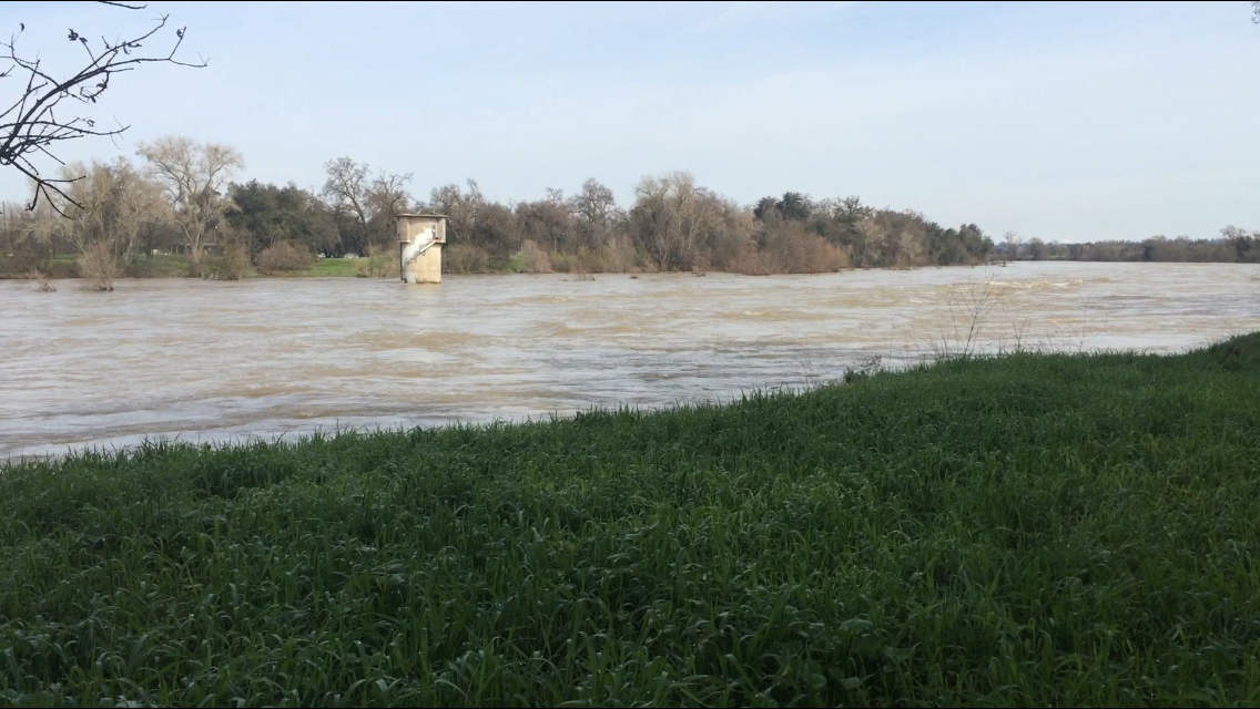
this is the real danger not the dam. That's why I've moved on to monitoring river levels.
I expect flooding monday morning. Especially the further south you go. I would have thought the opposite just in my head, but I'm following the data.
thank you very much for the picture.
Here is an amazing resource for finding data on everything water related in the area.
Everybody can stay informed
The Lake has been able to drop almost 40 feet from the super critical time when I was on the edge of my seat just watching hoping they could stabilize this.. If they had acted even 2 hours too slow or acted in a less decisive manner.. Not increasing the flows enough.. If they did that while also not evacuating.. This could have been one of the worst tragedies in the USA in a Long time.
I don't run on fear anymore.. In fact I should probably be working in disaster mitigation or media.
but yea now they have some room to work with. It's a much better picture for the dam. the repairs what like 50 to 100 million I think? Pay up guys.. just do it.. you have to. I can't believe we still put people's lives at risk like this..
Other dams better be on notice.. You can't have a non capped spillway.. A DIRT spillway? And of course they removed allt he trees to make the trees not rip the ground out, but are we for real? I can't even leave a hose on in the back without causing erosion..
So the good news is these people must have been almost #ting their pants..
It's going to motivate people to fix these issues.
the people evacuated are mad and confused.. They want answers.. They probably won't get the best answers unless they read this thread.. Media runs on emotion that's how they get money... People use media emotion like a drug. But I saw them misnaming things misquoting things and just all aroudn not doing a very good job, so now this is my personal vendetta.. I'm watching this day in and out.
And I would love any help anyone can give me on this.
Especially if you are local.
but anyone who sees a forecast or knows the snow pack or whatever it is..
This situation won't be safe for the foreseeable future. It's stable, but it's not safe. So the analogy our patient was in critical condition.. a few mg here a wrong reading here and we lose the patient. Now we have them in stable condition, but they're going to be in the hospital for at least a year.
but the thing that caused their sickness is not likely to re manifest.
edit on 17-2-2017 by Reverbs because: (no reason given)
a reply to: LadyGreenEyes
Interesting seems discussion related to the Lucifer storms and rain fall does not compute to most people, thanks for your reply.
Here is something I saw after posting my thoughts that was rather interesting.
www.youtube.com...
Interesting seems discussion related to the Lucifer storms and rain fall does not compute to most people, thanks for your reply.
Here is something I saw after posting my thoughts that was rather interesting.
www.youtube.com...
originally posted by: antar
a reply to: LadyGreenEyes
Interesting seems discussion related to the Lucifer storms and rain fall does not compute to most people, thanks for your reply.
there are no working links to anything real calling any storms lucifer.
3/4 of an inch of rain at the dam today. So far.
Lake is at 859 feet and falling. (so it is still likely they will hit 850 which is their target before the real rains hit.)
In Flow is 25,000 cfs..
And they have further dropped the outflow to 75,000 cfs.
So far none of the rivers are in flood stage. In fact the ones closer to oroville dam, the monitoring stations are less than yesterday.
edit
on 17-2-2017 by Reverbs because: (no reason given)
(post by ALSGoes4th removed for a serious terms and conditions violation)
now its time to move on from monitoring to digging into why these failures happened. i myself am pretty sure why but very few within the media are
asking the real questions. pretty sure its the reason they keep putting a sheriff in front of the press. simply cause he has no relation to the DWR
other then working with them through this event. i myself am pretty confident the money was most likely appropriated just like the money that was
earmarked for road repairs. i want some butts
a reply to: Reverbs
I am concerned, even after all that you said, that the rain they're going to be having over the next week or so will have a larger impact that some expect.
I came across this video a short while ago which makes me wonder even more how this will all turn out:
Perhaps I'm a worrywart but I don't want to see the dam or spillway go bye-bye.
a reply to: dianajune
Ok I watched thanks for the video.
She lists some opinions. And at least she knows the right spot to look the erosion up near the emergency spillway..
But then she goes on to say she doesn't have any data on the dam.. That she hasn't looked into it. That she doesn't know how much water these storms are bringing.. She doesn't know whether or not the emergency spillway will be over topped again.
She has a gut feeling something bad will happen. So while she is an engineer she's not acting as an engineer in that video.
But if you think the reason I am in this thread everyday checking numbers and re evaluating what I think might happen is because it's super safe awesome high five man.. It's not the case. I'm watching so closely because it's still a dangerous situation. I just know much better what has a chance of happening. It takes a lot of time to grasp everything you need to think about here and if you havn't been watching the entire time you just won't have as much data as someone who has.
The difference between me and these random engineers is I'm doing math.
I wish any one of the engineers people are posting about in this thread ran some numbers instead of guessing things.
She mentions for instance the engineers working on the dam know exactly days in advance what the inflows into the lake will be.. But she doesn't take the time to run those numbers.
I mentioned a target water level at 850 feet above sea level. That's a target for a specific reason. They hit that and the lake can be used as controlled release flood control.
Here are the water levels for the last 30 days:
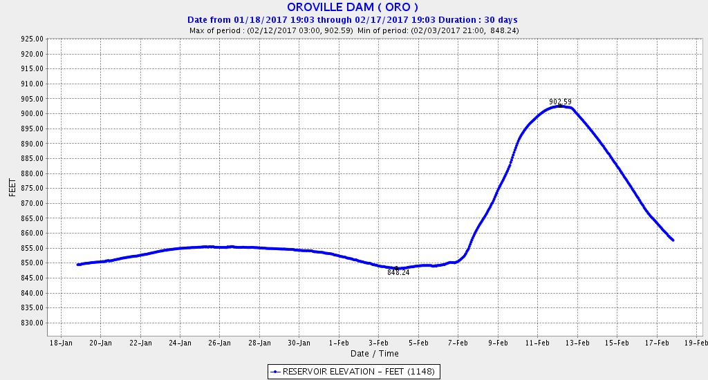
The dam has received about 2 inches of rain on that downslope.. at the end... it didn't even make a dent in the dropping levels. You see I actually know what I'm looking at because I've been doing back research and really understanding the whole system..
Do you guys think with "crazy storms!!" coming they would have lowered the outflow from 100,000 cfs, to 90,000 cfs to 85,000 to 80,000 to 75,000 and NOW to 70,000 cfs? They are easing burden on the rivers downstream.
you can see the river levels here: River levels
Almost all the sensor stations have been allowed to return to normal river levels.
They are not expecting to have to use the emergency spillway. In fact it's only ever been used ONCE.
And they didn't have to let it get used once.. They didn't but they turned off the water for repairs and checking out the spillway and turned off the power station which is 14,000 cfs possible outflow as well.. That won't get turned back on in the near future I am hearing, but they are clearing debris from the back flow off the main spillway so that it will be ready to be turned back on..
What got us to this place is montrous inflows into the lake at 150,000 to 200,000 cfs.. And with them turning on and off the main spill way and finally running it at only 55,000 cfs.. they were only trying to not really use that spillway so they could work on it... Well then the emergency spillway is used for the first time in it's life from 50 years ago and they go oh yea that's not a good idea... So switched back..
If they had not tried to rely on an "EMERGENCY" spill way in the first place trying to save money, and hell if they had listened to the report in 2005 that said they needed a concrete cap on that side of the hill.. Well things would be safer now.
I don't see any reason they would need to risk any further damage to the emergency spillway, and they see that too.
what really sucks is at some point they will have to fix the main spillway and when they are doing that they can't run any water down it. So because of that it would be ideal for them to get the power station turned back on.
I also don't like how she talks about a dam failure as if the Dam has issues. No one is saying the dam might fail only the emergency spillway..
I have a question for you guys to check understanding..
If the emergency spillway collapsed right now how much water would be released?
None.
Ok I watched thanks for the video.
She lists some opinions. And at least she knows the right spot to look the erosion up near the emergency spillway..
But then she goes on to say she doesn't have any data on the dam.. That she hasn't looked into it. That she doesn't know how much water these storms are bringing.. She doesn't know whether or not the emergency spillway will be over topped again.
She has a gut feeling something bad will happen. So while she is an engineer she's not acting as an engineer in that video.
But if you think the reason I am in this thread everyday checking numbers and re evaluating what I think might happen is because it's super safe awesome high five man.. It's not the case. I'm watching so closely because it's still a dangerous situation. I just know much better what has a chance of happening. It takes a lot of time to grasp everything you need to think about here and if you havn't been watching the entire time you just won't have as much data as someone who has.
The difference between me and these random engineers is I'm doing math.
I wish any one of the engineers people are posting about in this thread ran some numbers instead of guessing things.
She mentions for instance the engineers working on the dam know exactly days in advance what the inflows into the lake will be.. But she doesn't take the time to run those numbers.
I mentioned a target water level at 850 feet above sea level. That's a target for a specific reason. They hit that and the lake can be used as controlled release flood control.
Here are the water levels for the last 30 days:
The dam has received about 2 inches of rain on that downslope.. at the end... it didn't even make a dent in the dropping levels. You see I actually know what I'm looking at because I've been doing back research and really understanding the whole system..
Do you guys think with "crazy storms!!" coming they would have lowered the outflow from 100,000 cfs, to 90,000 cfs to 85,000 to 80,000 to 75,000 and NOW to 70,000 cfs? They are easing burden on the rivers downstream.
you can see the river levels here: River levels
Almost all the sensor stations have been allowed to return to normal river levels.
They are not expecting to have to use the emergency spillway. In fact it's only ever been used ONCE.
And they didn't have to let it get used once.. They didn't but they turned off the water for repairs and checking out the spillway and turned off the power station which is 14,000 cfs possible outflow as well.. That won't get turned back on in the near future I am hearing, but they are clearing debris from the back flow off the main spillway so that it will be ready to be turned back on..
What got us to this place is montrous inflows into the lake at 150,000 to 200,000 cfs.. And with them turning on and off the main spill way and finally running it at only 55,000 cfs.. they were only trying to not really use that spillway so they could work on it... Well then the emergency spillway is used for the first time in it's life from 50 years ago and they go oh yea that's not a good idea... So switched back..
If they had not tried to rely on an "EMERGENCY" spill way in the first place trying to save money, and hell if they had listened to the report in 2005 that said they needed a concrete cap on that side of the hill.. Well things would be safer now.
I don't see any reason they would need to risk any further damage to the emergency spillway, and they see that too.
what really sucks is at some point they will have to fix the main spillway and when they are doing that they can't run any water down it. So because of that it would be ideal for them to get the power station turned back on.
I also don't like how she talks about a dam failure as if the Dam has issues. No one is saying the dam might fail only the emergency spillway..
I have a question for you guys to check understanding..
If the emergency spillway collapsed right now how much water would be released?
None.
edit on 17-2-2017 by Reverbs because: (no reason given)
originally posted by: TheScale
now its time to move on from monitoring to digging into why these failures happened. i myself am pretty sure why but very few within the media are asking the real questions. pretty sure its the reason they keep putting a sheriff in front of the press. simply cause he has no relation to the DWR other then working with them through this event. i myself am pretty confident the money was most likely appropriated just like the money that was earmarked for road repairs. i want some butts
Whoever ignored this report would be at the top of my list.
31 pages PDF file
2005 report on Oroville Dam
However, the unarmored ungated-spillway design approved under the original license was
based on the erroneous assumption that Marysville Dam would be completed in the then near
future and the ungated spillway would soon be relegated exclusively to emergency (ESRD)
purposes.
In FERC Engineering Guidelines, operational spillways correspond to service or auxiliary
spillways. The lack of a spillway for the ungated spillway in the circumstances prevailing at
Oroville Dam does not meet FERC’s Engineering Guidelines for service or auxiliary spillways.
Because Oroville Dam is currently undergoing relicensing and the Dam is not in
conformity with the Commission’s Engineering Guidelines, it is the duty of the Commission to
establish procedures to bring the Dam into conformity (consistent with federal law, including the
National Wild & Scenic Rivers and Federal Power Acts) as part of its relicensing review.
Intervenors have repeatedly urged the licensee to resolve—in the licensing
proceeding—the issue of the nonconformity of the physical facilities of Oroville Dam and
controlling ACE flood-operations rules with FERC’s Engineering Guidelines
Basically Oroville Dam isn't up to the standards based on assumptions of other dam's being built. As long as the emergency spillway was intended only for emergencies it made sense but because it's sort of temporary status of a regular spillway never ended it needs to be concrete lined.
Below is why they did not have to listen to this report. The people making the report classify as "intervenors"
(“[T]he process for relicensing our Oroville Facilities by the
Federal Energy Regulatory Commission is not the proper forum for resolving regional flood
management issues.”) They reached this conclusion because “Congress granted exclusive
jurisdiction on Oroville flood-control operations to the Secretary of the Army.”14 Setting aside
the legal merits or relevance of these conclusions, DWR’s statements do not respond to the
issues and requests raised by intervenors.
So if anyone is wondering like what exactly did the report say I can't look through 31 pages...
This might be the most straightforward onvious report I've ever read..
Here:
The discharge area below the emergency spillway is not armored and extensive
erosion would take place if the emergency spillway were used. The spillway road
and possibly high voltage transmission towers would be impacted. (p. II-1) Because
the area downstream from the emergency spillway crest is an unlined hillside,
significant erosion of the hillside would occur. (p. II-5) “The hillside between the
emergency spillway and the Feather River would be subject to severe erosion when
water flows over the spillway. Depending on the rate of flow, the erodable area . . .
could range from 50 to 70 acres
Seems pretty understandable why anyone would ignore that. I mean I sure would.. They just weren't clear enough when they stated:
"if water tops the emergency spillway IT WILL ERODE THE HILL MASSIVELY.. It's an easy thing to gloss over..
12 years later the risk they took that was brought up in the inappropriate forum is finally realized.
edit on 17-2-2017 by Reverbs because:
(no reason given)
a reply to: dianajune
Ok guys they had lowered the outflow to 65,000 cfs, and now down to 60,000 cfs.
the inflow is sitting around 40,000 cfs.
Lake height is around 854.4 feet (Not falling quite as rapidly as I said it would, but obviously it won't because the outflow has been reduced so much)
Southern California got drenched. And that should be hitting the Dam later, not sure how much later.
I was listening to Joe Rogan's podcast yesterday and they started wondering if their roof might cave in.. Of course in LA they are not used to rain like this.
Those same rains havn't rally hit Oroville. They've had rain pretty much this whole time yesterday and today, but it's been light rain.. today maybe 3/4 of an inch.
So I'll be back later after watching some weather radar and things. .
THIS is the test. If they get past this storm without concern then I have full confidence they will manage the situation into the future until the dam is fully repaired AND emergency spillway capped.
The powerlines were re-routed or re strung. So those to my knowledge have been reconnected to the power station. That's one step in getting the dam power station turned back on. without the line connected the electricity has no place to go..
They also need to clean it out, and also clean out the back flow from the main spillway. That is part of the reason for the lowered outflow. So they can work easier down at the bottom of the main spillway.
edit on 18-2-2017 by Reverbs because: (no reason given)
a reply to: Reverbs
How a bout seismic activity to add to the mix. Oroville lake does have history of seismic activity in relationship to the lake level.
I know a little doomish but something to consider and I'm sure their monitoring.
Found a paper about EARTHQUAKE AND LAKE LEVELS AT OROVILLE, CALIFORNIA
Also with so much of the side of the lake eroded down stream the displacement of land could add to the instability of pressure on the plane.
How a bout seismic activity to add to the mix. Oroville lake does have history of seismic activity in relationship to the lake level.
I know a little doomish but something to consider and I'm sure their monitoring.
Found a paper about EARTHQUAKE AND LAKE LEVELS AT OROVILLE, CALIFORNIA
Detailed seismographic monitoring since 1975 has revealed a relation of earthquake occurrences within 20 km of Lake Oroville to the seasonal variations in lake levels. Seismicity decreases during filling of the lake and increases during drawdown.
Thus, not only does the filling of the lake and the resulting increase in subsurface pore pressure influence seismicity, but also the reservoir drawdown promotes failure by reducing the effective stress. In this regard, Simpson (1976, p. 146) noted the paradox "that if there is an indication of an impending increase in the level of seismicity, one of the obvious ways of decreasing danger downstream from the dam---the rapid emptying of the reservoir---may in fact increase the danger by triggering a further increase in the level of activity." This scenario is reflected in figure 3, which shows that the most rapid drawdowns in lake levels are accompanied by the greatest seismic activity.
Also with so much of the side of the lake eroded down stream the displacement of land could add to the instability of pressure on the plane.
a reply to: Observationalist
You know a meteor could hit the dam at any moment right?
I'm just not expecting that to happen.
If you are going to bring up a study on Earthquakes at least say that the earthquakes happen at the fastest outflow of the lake.. We already had the fastest outflow of the lake.. So why are you bringing this up as the lake levels are just about to go back up?
Not to mention the Dam is built to withstand quakes and has never been damaged in it's lifetime by an Earthquake.
It's inspected every 5 years for earthquake readiness.
and by the way almost all of the quakes they use in this study are tiny quakes. You couldn't even feel them.
edit on 18-2-2017 by Reverbs
because: (no reason given)
a reply to: Reverbs
Seriously Reverb, your way out of line with your meteor comment.
My post about earthquakes is relevant and in context with the current situation at Lake Oroville.
Oroville Dam is also at seismic risk
POSTED ON FEBRUARY 14, 2017 BY TEMBLOR
I'm not alone in my concernes. And like I said I'm sure they are monitoring this too.
Dude it's not like we are running around going crazy in fear. It is a simple observation and something to keep in mind. Fear is not the goal awaness and preparedness is.
Seriously Reverb, your way out of line with your meteor comment.
My post about earthquakes is relevant and in context with the current situation at Lake Oroville.
Oroville Dam is also at seismic risk
POSTED ON FEBRUARY 14, 2017 BY TEMBLOR
But that’s not Oroville’s only problem: It is also associated with one of the largest “induced” (induced or promoted by actions of man) earthquakes ever recorded in the U.S.: A M=5.8 event in 1975 (According to the USGS). While this may sound like a foreign concept, the filling of some reservoirs has been shown to be associated with a significant increase in seismicity.
An interesting question is whether after 5 years of drought, the large and rapid refilling of the Lake this winter—from 1/3 full to brim full—could set the stage for future induced earthquakes at the Lake. It should be noted that the dam has been regularly subject to rigorous site specific seismic hazard analysis. Nonetheless, both the spillway integrity and seismic resilience point to the same need for safety, strength, and vigilance.
I'm not alone in my concernes. And like I said I'm sure they are monitoring this too.
Dude it's not like we are running around going crazy in fear. It is a simple observation and something to keep in mind. Fear is not the goal awaness and preparedness is.
edit on 18-2-2017 by Observationalist because: (no reason given)
originally posted by: Reverbs
a reply to: dianajune
.......................................................Those same rains havn't rally hit Oroville. They've had rain pretty much this whole time yesterday and today, but it's been light rain.. today maybe 3/4 of an inch.
So I'll be back later after watching some weather radar and things. .
THIS is the test. If they get past this storm without concern then I have full confidence they will manage the situation into the future until the dam is fully repaired AND emergency spillway capped.
I agree. Hopefully they will get past this storm without having any further issues with the spillway. We all need to remain in prayer about this.
Here's an excerpt from the NWS Flood warning that was issued not long ago:
358 PM PST SAT FEB 18 2017
The National Weather Service in UNLOCALIZED SITE has issued a *
Flood Warning for Urban Areas and Small Streams in...
Colusa County in central California...
Yolo County in central California...
Sutter County in central California...
Solano County in central California...
Plumas County in northern California...
Alpine County in northern California...
Placer County in central California...
Shasta County in northern California...
Lassen County in northern California...
Amador County in northern California...
Tuolumne County in northern California...
Sacramento County in central California...
Lake County in central California...
Stanislaus County in central California...
San Joaquin County in central California...
El Dorado County in northern California...
Calaveras County in northern California...
Tehama County in northern California...
Butte County in northern California...
Glenn County in central California...
Sierra County in northern California...
Yuba County in central California...
Nevada County in northern California... *
Until 400 PM PST Thursday *
Interior Northern California will experience another significant uptick in flooding problems starting late Sunday Night and continuing through Monday Night as an intense Atmospheric River type storm arrives. *
Our entire region has saturated soils and many flooded areas already...this will enhance the impact of additional heavy rains. * Additional stress will be placed on levees, rivers, creeks, and streams. *
We may see flooding in locations which haven`t been impacted in many years. * We are strongly advising all residents in interior Northern California to be prepared for flooding.
NWS Flood Warning
edit on 18-2-2017 by dianajune because: typo
a reply to: Observationalist
Did you not listen to anything I said? Read the reports yourself.
I read the entire thing in case you were wondering.
these quakes can happen at the highest rate of draining of the lake.
Do you know when that was?
it's in the past.
Now the lake looks like it will stabilize around 853.5, and then begin rising again.
Go check some seismographs if you are worried, but you're not saying anything relevant.
Why would quakes that have NEVER damaged the dam be super important right now?
The Quary to the west and north causes more vibration in the dam than most earthquakes would of the magnitude they list.
you wouldn't even feel those quakes.
In your same study if you had cared to read it it goes on to talk about the dam and what it's built to withstand. It's built for large quakes. And no one is expecting any.
You are out of line for trying to bring in random things you've heard without wondering to yourself if they mean anything or have you not noticed by now FEAR is a big seller.. And fear selling is the cause of a lot of fake news.. I'm a conspiracy guy through and through but I don't buy into nonsense.
Simulation of Oroville
spillway failure
There are three videos at the link.
Water managers issued evacuation orders for nearly 200,000 Californians just hours before they thought an emergency spillway at Oroville dam could fail. Emergency officials said it would send a 30 foot wall of water downstream.
That might be hard to imagine, but a computer simulation by UC Santa Cruz research geophysicist Steven Ward shows flood waters would hit highway 70 in about 30 minutes. In less than three hours, it would hit Highway 99. After 9 hours, it would fan out to cover a 231-square mile area.
Ward says it would be a massive wave near Oroville. The videos of the main spillway releasing 100,000 cubic feet per second pale in comparison. “We’ve seen all week the videos of the regular spillway operating at full speed at about 100,000 cubic feet per second. This partial break is about 20 times that. It’s going to overpower the dikes and levees for sure,” says Ward.
There are three videos at the link.
originally posted by: dianajune
I agree. Hopefully they will get past this storm without having any further issues with the spillway. We all need to remain in prayer about this.
Here's an excerpt from the NWS Flood warning that was issued not long ago:
358 PM PST SAT FEB 18 2017
The National Weather Service in UNLOCALIZED SITE has issued a *
Flood Warning for Urban Areas and Small Streams in...
Colusa County in central California...
Yolo County in central California...
Sutter County in central California...
Solano County in central California...
Plumas County in northern California...
Alpine County in northern California...
Placer County in central California...
Shasta County in northern California...
Lassen County in northern California...
Amador County in northern California...
Tuolumne County in northern California...
Sacramento County in central California...
Lake County in central California...
Stanislaus County in central California...
San Joaquin County in central California...
El Dorado County in northern California...
Calaveras County in northern California...
Tehama County in northern California...
Butte County in northern California...
Glenn County in central California...
Sierra County in northern California...
Yuba County in central California...
Nevada County in northern California... *
Until 400 PM PST Thursday *
Interior Northern California will experience another significant uptick in flooding problems starting late Sunday Night and continuing through Monday Night as an intense Atmospheric River type storm arrives. *
Our entire region has saturated soils and many flooded areas already...this will enhance the impact of additional heavy rains. * Additional stress will be placed on levees, rivers, creeks, and streams. *
We may see flooding in locations which haven`t been impacted in many years. * We are strongly advising all residents in interior Northern California to be prepared for flooding.
NWS Flood Warning
Yes and that's what I've been trying to warn about.
I want to urge this into everyone's mind RIGHT NOW
The Dam is not the issue..
No matter what they do with the Dam you guys ARE going to get flooding.
I posted about that pages ago.
MONDAY MORNING is the start.. All through Monday it will get worse.. Tuesday and Wednesday it will still be raining, just not as much.. So it will still get worse probably.
I would be alert if up late sunday night say after midnight at least or VERY early monday I'd have the news on as much as possible.
The worst flooding according to me is going to be further south. I'm just going on river levels till flooding, I don't know the contour of the land. Don't be surprised to see them turn the outflow on that dam down even more to help out.
originally posted by: dianajune
Simulation of Oroville spillway failure
Water managers issued evacuation orders for nearly 200,000 Californians just hours before they thought an emergency spillway at Oroville dam could fail. Emergency officials said it would send a 30 foot wall of water downstream.
That might be hard to imagine, but a computer simulation by UC Santa Cruz research geophysicist Steven Ward shows flood waters would hit highway 70 in about 30 minutes. In less than three hours, it would hit Highway 99. After 9 hours, it would fan out to cover a 231-square mile area.
Ward says it would be a massive wave near Oroville. The videos of the main spillway releasing 100,000 cubic feet per second pale in comparison. “We’ve seen all week the videos of the regular spillway operating at full speed at about 100,000 cubic feet per second. This partial break is about 20 times that. It’s going to overpower the dikes and levees for sure,” says Ward.
There are three videos at the link.
yes.. Good thing that didn't happen. That's what had me on the edge of my seat.. When I realized how close the erosion was to the spillway.. It was in the middle of the night when the water level stopped topping the dam so I stayed up all night frantically tring to find a video in the morning of the site.
What I saw was even closer to the base of the emergency spillway and much larger than they had made it sound.
Like damn...
But at the same time the pressure was going down every minute on that wall that had not been in fact damaged.
So that 30 foot wall goes down to 870 feet above sea level.. the lake at 853.5 is 17 feet before it reaches the base of the wall..
In other words we have 47 feet just about to work with. before it risks erosion up there that could risk the emergency spillway that could if worst case scenario happened, could do what is shown in those simulations.
but yea they will try to hold water in the lake without releasing it so fast. Oroville dam has the most space to fill up I think, the other dams are pretty full already. Not good...
new topics
-
Only two Navy destroyers currently operational as fleet size hits record low
Military Projects: 2 hours ago -
George Stephanopoulos and ABC agree to pay $15 million to settle Trump defamation suit
Mainstream News: 7 hours ago
top topics
-
George Stephanopoulos and ABC agree to pay $15 million to settle Trump defamation suit
Mainstream News: 7 hours ago, 16 flags -
The Mystery Drones and Government Lies
Political Conspiracies: 17 hours ago, 14 flags -
Light from Space Might Be Travelling Instantaneously
Space Exploration: 15 hours ago, 9 flags -
The MSM has the United Healthcare assassin all wrong.
General Conspiracies: 15 hours ago, 8 flags -
More Bad News for Labour and Rachel Reeves Stole Christmas from Working Families
Regional Politics: 13 hours ago, 8 flags -
2025 Bingo Card
The Gray Area: 16 hours ago, 7 flags -
Only two Navy destroyers currently operational as fleet size hits record low
Military Projects: 2 hours ago, 6 flags
active topics
-
The Mystery Drones and Government Lies
Political Conspiracies • 70 • : WeMustCare -
-@TH3WH17ERABB17- -Q- ---TIME TO SHOW THE WORLD--- -Part- --44--
Dissecting Disinformation • 3683 • : duncanagain -
One out of every 20 Canadians Dies by Euthanasia
Medical Issues & Conspiracies • 23 • : Daughter2v2 -
Former DNI-Congressman John Ratcliffe says the U.S. Government is Intimidated by UFOs.
Aliens and UFOs • 39 • : WeMustCare -
Drones everywhere in New Jersey
Aliens and UFOs • 165 • : Zaphod58 -
Mass UAP events. DC. Machester Airport, UFOs over sub base in CT, Nuke bases.
Aliens and UFOs • 57 • : WeMustCare -
FBI Director CHRISTOPHER WRAY Will Resign Before President Trump Takes Office on 1.20.2025.
US Political Madness • 26 • : WeMustCare -
George Stephanopoulos and ABC agree to pay $15 million to settle Trump defamation suit
Mainstream News • 10 • : WeMustCare -
President-Elect DONALD TRUMP's 2nd-Term Administration Takes Shape.
Political Ideology • 330 • : WeMustCare -
Light from Space Might Be Travelling Instantaneously
Space Exploration • 24 • : norhoc4