It looks like you're using an Ad Blocker.
Please white-list or disable AboveTopSecret.com in your ad-blocking tool.
Thank you.
Some features of ATS will be disabled while you continue to use an ad-blocker.

BREAKING: Fearing collapse of emergency spillway at Oroville Dam, Oroville evacuated
page: 13share:
a reply to: Reverbs
Ever since you got on this thread you have been desperately trying to keep our attention away from the dam. And now your doing your own little doom porn dance about the valley flooding. What gives? Why don't you want to talk about the dam which is the subject of the thread. Why do we have to focus on the flood.
The sac valley deals with floods all the time, there will be some local flooding and then it will dry out and be back to normal. The DAM is the subject if this thread. If the flooding is such an issue start another thread and bless everyone there with your important information.
THE DAM IS NOT THE ISSUE
Ever since you got on this thread you have been desperately trying to keep our attention away from the dam. And now your doing your own little doom porn dance about the valley flooding. What gives? Why don't you want to talk about the dam which is the subject of the thread. Why do we have to focus on the flood.
The sac valley deals with floods all the time, there will be some local flooding and then it will dry out and be back to normal. The DAM is the subject if this thread. If the flooding is such an issue start another thread and bless everyone there with your important information.
edit on 18-2-2017 by Observationalist because: Removed snarky remark, it didn't help
originally posted by: Observationalist
a reply to: Reverbs
THE DAM IS NOT THE ISSUE
Ever since you got on this thread you have been desperately trying to keep our attention away from the dam. And now your doing your own little doom porn dance about the valley flooding. What gives? Why don't you want to talk about the dam which is the subject of the thread. Why do we have to focus on the flood.
The sac valley deals with floods all the time, there will be some local flooding and then it will dry out and be back to normal. The DAM is the subject if this thread. If the flooding is such an issue start another thread and bless everyone there with your unfathamable knowledge.
I came into this thread saying uh oh this looks really bad!
Go check if you are wondering.
I was worried as hell.
The worry is over.
Maybe you just don't know as much as I do.
If the Dam might be in trouble WHY have they lowered the outflow all the way down to 55,000 cfs?
What level will the lake rise to?
What parts of the rivers are already at risk of flooding and which are at normal levels?
Most importantly..
Will the Dam be overtopped?
And check my posts in this thread I was right about every little thing I said. I even made predictions of the future that were also right.
You are the one trying to bring up irrelevant issues.
How can you say I am diverting attention of a Dam if I am the one bumping this topic over and over..
Are you insane?
Im' trying to keep people up to date on a Dam and the flooding.
grow up. I don't work for the government if that's what you are wondering.
Do your research. What on the Dam is going to break and why? Tell me what is it specifically you are worried about.
I am not doing anything desperately. I am an extremely calm person. That's why I can use my head and not run around all emotional feeling like people talking about dams are trying to cover up problems with dams.. Come on now.. Be serious.
You can have the same knowledge as me if you took the time. I gave you some great resources earlier.. You can plot any graph you like you can dig into the data..
PEOPLE in THIS THREAD have expressed that they live in the area.. They will be reading this thread.
MY information is important..
You are not providing information.
I'll say again:
WATCH the news monday morning.. Keep an eye out.. These are Flood Warnings, not Flood watches. ALL the way through Thursday..
the worst will start monday and it will get worse maybe through Tuesday..
But if you think the Dam is going to have massive earthquakes and it's going to fill 50 feet of lake and its' all a coverup in order to murder people downstream be my guest.. They are NOT trying to Murder People by canceling the evacuation order.
edit on 18-2-2017 by Reverbs because: (no
reason given)
a reply to: Observationalist
To address your concerns about my motives..
Page 1 of the thread..
Someone says:
ME :
See? I was worried about imminent failure.
The situation did not stay the same.
that's all.. And My next post was shutting down someone who was trying to deny this as a topic of discussion.
Are you HOPING something bad happens?
I hope not.
That was of course the beginning of my knowledge quest. When I get interested in something and it's this important to watch I research EVERYTHING.. I knew absolutely nothing about dams before this thread. Now I've spent at least 24 hours learning.. over this last week. I spend more time on this Dam than anything else and I am supposed to be running my own threads on other topics right now that are very important.. But I'm holding off. I don't have the time..
this is more important for now.
Page 3
The Situation at the Dam is greatly improved with 50 feet of water almost to fill..
I have no expectation that the emergency spillway will be overtopped.
And therefore I have no expectation of any erosion,
and therefor I have no expectation of a emergency spillway wall collapsing..
the rest of the dam is sitting in the same condition either way.
What's the most dangerous for people right now.. the biggest danger are the rivers overflowing.
And those are the warning issued right now.
So
@ dianajune
Thank You for posting the Flood Warnings for ALL those Counties.
Stay safe guys.
Watch the News!
To address your concerns about my motives..
Page 1 of the thread..
Someone says:
Old news? Didn't this happen like 2 says ago?
ME :
think harder.. This is now..
OR did you think the lake water level magically went away?
the erosion continued now they warn of imminent failure.
yea?
See? I was worried about imminent failure.
The situation did not stay the same.
that's all.. And My next post was shutting down someone who was trying to deny this as a topic of discussion.
Are you HOPING something bad happens?
I hope not.
That was of course the beginning of my knowledge quest. When I get interested in something and it's this important to watch I research EVERYTHING.. I knew absolutely nothing about dams before this thread. Now I've spent at least 24 hours learning.. over this last week. I spend more time on this Dam than anything else and I am supposed to be running my own threads on other topics right now that are very important.. But I'm holding off. I don't have the time..
this is more important for now.
Page 3
originally posted by: Reverbs
originally posted by: In4ormant
The live feed is confusing. One screen says it has failed and the other says it could. Which is it?
It looks like it could fail at any minute.. the side of the lake is eroding..
the spill way is a structure that is broken already, but that is not a structure that holds water back..
is that your confusion?
they increased the flow into the spillway to 100,000 cubit feet/second.. Hoping to release pressure to the left of that where the lake is going over the edge of the dam..
The Situation at the Dam is greatly improved with 50 feet of water almost to fill..
I have no expectation that the emergency spillway will be overtopped.
And therefore I have no expectation of any erosion,
and therefor I have no expectation of a emergency spillway wall collapsing..
the rest of the dam is sitting in the same condition either way.
What's the most dangerous for people right now.. the biggest danger are the rivers overflowing.
And those are the warning issued right now.
So
@ dianajune
Thank You for posting the Flood Warnings for ALL those Counties.
Flood Warning for Urban Areas and Small Streams in...
Colusa County in central California...
Yolo County in central California...
Sutter County in central California...
Solano County in central California...
Plumas County in northern California...
Alpine County in northern California...
Placer County in central California...
Shasta County in northern California...
Lassen County in northern California...
Amador County in northern California...
Tuolumne County in northern California...
Sacramento County in central California...
Lake County in central California...
Stanislaus County in central California...
San Joaquin County in central California...
El Dorado County in northern California...
Calaveras County in northern California...
Tehama County in northern California...
Butte County in northern California...
Glenn County in central California...
Sierra County in northern California...
Yuba County in central California...
Nevada County in northern California..
UNTIL THURSDAY 4PM
Stay safe guys.
Watch the News!
edit on 18-2-2017 by Reverbs because: (no reason given)
a reply to: Reverbs
Work for the government? Never thought of it till now.
Murder people down stream? What happen to you were pretty level headed but that's ridiculous.
I just wanted to talk more about the status of the dam, spillway and newley eroded sides of the dam in relation to potential seismic activity which Lake Oroville has a unique history with.
But obviously I can't, so....
No big deal. I will say you have been providing some great info and resources, thank you for that.
I hope nothing goes bad on Monday. I live in Sacramento 2 miles from one of its rising rivers (I posted about it in this thread).
Any plans to start another thread about your concernes for Monday?
originally posted by: Observationalist
a reply to: Reverbs
Work for the government? Never thought of it till now.
Murder people down stream? What happen to you were pretty level headed but that's ridiculous.
I just wanted to talk more about the status of the dam, spillway and newley eroded sides of the dam in relation to potential seismic activity which Lake Oroville has a unique history with.
But obviously I can't, so....
No big deal. I will say you have been providing some great info and resources, thank you for that.
I hope nothing goes bad on Monday. I live in Sacramento 2 miles from one of its rising rivers (I posted about it in this thread).
Any plans to start another thread about your concernes for Monday?
if the government lifted an evacuation order ahead of a monster storm and there was severe danger at the dam? And that dam broke? Yes I would call that murder. People would surely die.. No question.. That was the worry.. A 30 foot wall of water. It really could have happened. I was watching the evacuation so slow like aaahhh aaahhh get them out of there! THey couldn't get out fast enough.. But they did get out and they should have gotten out. It was THAT bad. The emergency spillway could have failed. BUT not because of it's structure, because of the dirt... The dirt stopped eroding.. The Wall never got weakened. It can still handle the same loads. And it shouldn't have to in the future if I am seeing things correctly.
I'm trying to get your head in the game at the right level by saying something outrageous so you come back into focus with me.
they wouldn't do that.
The reports about earthquakes are a non issue as the reports are about quickly lowering the lake level. That already happened.. They lowered the level pretty close to maximum speed. No quakes.. And the highest quake I am aware of for the area is in the 5 range.. but 99% of the quakes are in the 2 range.. No quakes are going to hurt the dam. That's just a VERY educated guess if you like.
As far as the status of the dam here's a little run down off the top of my head.
1)the erosion at the main spillway has stopped headcutting about 4 or 5 days ago.. Even with the 100,000 cfs it had.
2)the erosion at the emergency spillway stopped headcutting ONLY when the water stopped overtopping that wall.
3)I don't expect any water to overtop the emergency spillway in the future.
4)no damage has happened to any structures that hold back water.
5)they will have the powerplant at the bottom of the dam turned back on in a week or 2 weeks. that's 14,000 cfs outflow
6)the repairs to the ground in front of the emergency spillway are enough to prevent the wall from being undermined
7)the water level is at 853.5 feet. the max level is at 900 feet before a dangerous situation develops.
8)the dam itself has no issue.
If I missed anything feel free to ask about the dam I might know the answer.
If not I can find an answer.
Watch the News Monday Morning as early as you can.. The river levels are much more dangerous than anything else right now.
AND no this IS the thread.
I'll be updating you guys on the dam, I'm not changing the subject.. It's just this has surpassed the danger at the dam. I would be a lunatic to not change focus. I have to watch the real danger. Once this storm has passed you know it will be all about the dam again.
Until then..
Stay safe.
Thank You again DianaJune for providing us with this information.
her post
Flood Warning for Urban Areas and Small Streams in...
Colusa County in central California...
Yolo County in central California...
Sutter County in central California...
Solano County in central California...
Plumas County in northern California...
Alpine County in northern California...
Placer County in central California...
Shasta County in northern California...
Lassen County in northern California...
Amador County in northern California...
Tuolumne County in northern California...
Sacramento County in central California...
Lake County in central California...
Stanislaus County in central California...
San Joaquin County in central California...
El Dorado County in northern California...
Calaveras County in northern California...
Tehama County in northern California...
Butte County in northern California...
Glenn County in central California...
Sierra County in northern California...
Yuba County in central California...
Nevada County in northern California..
UNTIL THURSDAY 4PM
DO NOT lose this link.
This will keep you informed on the danger at the dam..
If that water level the lake height.. If you see that closing in on 900 feet... That's BAD...
ok?
edit on 18-2-2017 by Reverbs because: (no reason given)
a reply to: Reverbs
Still appreciating all your info.
With so much rain this season, there are still flood concerns unrelated to Oroville Dam. And that is up and down the state currently. Flash floods, waterways overflowing, levees damaged, down to city streets drainage backing up and water pooling under overpasses. From drought concerns to flood concerns overnight, it's crazy.
Anyway, while we're keeping track of Oroville, just wanted to share a couple links about a dam problem in general. While it's true that dams help with flood control, they really create reservoirs for water storage for agriculture, drinking, recreation. Unfortunately, water flowing in carries silt and sediment with it:
Sedimentation is a building problem in the West's reservoirs
All Dams are Temporary - Sedimentation
One way to create more storage (because of sedimentation or just increase need for water) is to raise the level of the spillway, which is not a bad thing unless the dam itself can't take the pressure. What I wonder now is if lake levels this year will be allowed to rise closer to current spillway levels in order to store more water, if any dams will have record storage levels. It might be tempting to do so, with all the record snow sitting ready to melt and flow down with seasonal warmer weather approaching. I wonder if dams can handle record storage levels.
Seasonal snow melt alone means water coming in will actually increase in the coming late Spring into Summer. If we have that plus increasing rains, it will be interesting to see what happens all around. Some years of heavy rains put water in lakes that had disappeared generations ago after settlers started to manage water and create water systems. And wildflowers shows are spectacular. But increased water can erode under highways and bridges (as happened even last year to a major interstate highway in the desert after a flash flood, in a drought year!), so I imagine flowing water will continue to cause more news in the coming months.
Oh, and Lake Oroville water ends up in Los Angeles, via a hundreds-of-miles canal system. Southern CA water doesn't end up in Oroville, it's actually the other way around. It's all part of the "water wars" in CA. Los Angeles (and southern CA) has always had to get their thirst quenched and need for water from somewhere, even from as far away as Colorado. That's more interesting history. (And has made for a great movie, Chinatown)
a reply to: desert
Well, Many Dams must be at record levels..
The overall storage levels are together 121% of the average.
Shasta is 91% full which is 126% of it's average..
Oroville is 81% full which is 118% of the average.
Some others are 100% full
Source
Live look. I think it's live to the best of my knowledge.. Other live feeds have been replays played "live" again..
It's dropped a little below 852 feet now.
I had to hide thee chat because people are amazingly ignorant.. Maybe the people looking for doom should go listen to that chat?
Anyway.. They have no idea what they are looking at.. They assume the water is coming out of a holw that needs to be fixed .. I forget ATS isn't the general population all the time.. Yikes..
edit on 19-2-2017 by Reverbs because: (no reason given)
To Reverbs:
You're welcome!
Here is an updated forecast. The region is under a high wind advisory until 4pm PST on Monday, and a high wind warning from 4pm Monday to 4am PST. As if things couldn't get worse:
Excerpt:
URGENT - WEATHER MESSAGE National Weather Service Sacramento CA
318 PM PST Sun Feb 19 2017
...Strong winds over northern California the next couple of days... .A strong Pacific storm will bring potentially damaging winds to northern California as it approaches and moves through the region. Breezy winds today and Monday will peak Monday evening through the night as this system pushes through. Downed trees and widespread, long-lasting power outages are likely especially Monday evening. Blowing debris hazards are also possible.
CAZ015-016-201400- /O.UPG.KSTO.HW.A.0002.170221T0300Z-170221T0900Z/ /O.NEW.KSTO.HW.W.0004.170221T0000Z-170221T1200Z/ /O.EXT.KSTO.WI.Y.0020.000000T0000Z-170221T0000Z/
Northern Sacramento Valley-
Central Sacramento Valley- Including the cities of Redding, Red Bluff, Chico, Oroville, and Marysville/Yuba City
318 PM PST Sun Feb 19 2017 ...WIND ADVISORY NOW IN EFFECT UNTIL 4 PM PST MONDAY... ...HIGH WIND WARNING IN EFFECT FROM 4 PM MONDAY TO 4 AM PST TUESDAY...
The National Weather Service in Sacramento has issued a High Wind Warning, which is in effect from 4 PM Monday to 4 AM PST Tuesday. The High Wind Watch is no longer in effect.
* TIMING...Gusty winds today will continue into Monday, then peak Monday evening into early Tuesday morning. *
WINDS...Winds today through Monday 20 to 30 mph with gusts to 40 mph. Winds Monday evening through early Tuesday morning gusting 50 to 65 mph.
* IMPACTS...Downed trees, blowing debris, and widespread, potentially long-lasting power outages.
PRECAUTIONARY/PREPAREDNESS ACTIONS... A High Wind Warning means a hazardous high wind event is expected or occurring. Sustained wind speeds of at least 40 mph or gusts of 58 mph or more can lead to property damage. A Wind Advisory means that winds of 35 mph are expected. Winds this strong can make driving difficult, especially for high profile vehicles. Use extra caution.
&& Interact with us via social media www.facebook.com/nws.sacramento www.twitter.com/nwssacramento
And here is another flood warning:
FLOOD STATEMENT
NATIONAL WEATHER SERVICE SACRAMENTO CA
257 PM PST SUN FEB 19 2017
...The Flood Warning continues for the following rivers in California...
Sacramento River Near Hamilton City ...
The Flood Warning continues for the following rivers in California..
Sacramento River At Tehama Bridge
Sacramento River At Vina Woodson Bridge
Sacramento River At Ord Ferry .
MANY LOCATIONS ON THE SACRAMENTO RIVER HAVE LOWER FORECASTS THIS AFTERNOON DUE TO DECREASED WATER RELEASES OUT OF KESWICK. Forecasts are based on present and forecasted meteorological and hydrologic conditions at time of issuance.
PRECAUTIONARY/PREPAREDNESS ACTIONS... Unlisted forecast points are expected to remain below monitor stage. All those affected by river conditions should remain alert for rapid changes and for possible forecast revisions. For more hydrologic information and stage definitions refer to the following web site:
www.wrh.noaa.gov...
The next statement will be issued Sunday February 19, 2017 at 900 PM.
Both warnings came from the following link:
NWS High Wind Advisory, High Wind Warning and Flood Warning Link
edit on 19-2-2017 by dianajune
because: Having issues with formatting of post....not sure why
Here's a live video link I came across re. the Oroville Dam spillway. It's nothing much and is just FYI. Just a very rainy and gloomy view of the
area:
It's still live as I write this at 8:42pm EST. It's not a replay....at least for now.
It's still live as I write this at 8:42pm EST. It's not a replay....at least for now.
edit on 19-2-2017 by dianajune because: typo
a reply to: Reverbs
I didn't claim to be an engineer. I did, however, post information from a dam engineer who is concerned about this dam, and believes there is a real problem there. Plus, don't act like I am the one who spoke of a 30' wall of water, because I am not. Nor is than inaccurate, for that matter. When a break does occur, you do, in fact, get a wall of water, and the size will be affected by the size of the break. For closer areas, that is a very real threat. Plus, with more rain coming, and with it, snow melt, a lot more water will be in play, and that means there is still a lot of potential for disaster. That they allowed people back in isn't exactly a surprise, either. Whether it was the right thng to do is what is up for debate, and that remains to be seen.
I really hope that nothing serious happens. However, I won't say it's unlikely to happen. I said the same about New Orleans, too. "Gloom and doom" many said. The levees would hold. No storm would hit directly. We all know what happened, though.
originally posted by: Reverbs
originally posted by: LadyGreenEyes
Can't believe they have people back already, all considered. Ten inches of rain expected now, too - source - which, when added to the snow melt, is quite a lot. Who knows how their repairs will hold up!?
Ah, quake possibilities. Yeah, that has to be considered. I read the dam sits right on a fault line. Great planning, eh??
the conflicting reports on the looting is because there was some crime but it was like individuals no widespread looting or rioting.. Know what I mean? I bet not many even saw it.
This link you gave is data and that's what we need in this thread.
Today there was aroud an inch of rain.. 10 inches is quite a different story.
by let's make this up in my head by this time tomorrow the lake should be 854 feet above sea level, giving it a space of about 50 feet to fill.
I'd have to do some math to imagine if that would be able that 10 inches would be able to fill that last 50 feet and then over top the emergency spill way.
That is a huge danger if it can overtop, but I'm not forecasting that.
Currently we are holding at around 30,000 cfs in flow into the lake.
They are holding the main spillway at 80,000 cfs down from 100,000 cfs.
That still gives us a net drain of 50,000 cfs.. For reference as shown to me earlier in this thread niagara falls is 84,000 cfs.
so look the point of the dam. It's supposed to be flood control.. The danger is in not being able to use it as flood control .. idealy you want to hold water in the lake and only outflow what the rivers can take hoping the lake won't fill up in the process.
because of what happened and the lake being over full they had to just drain it as fast as possible without the ability to consider river levels..
So I havn't checked the other dams in the area like Shasta. I'll do that in a bit. If they all have room then the rain might not make the rivers flood.. but if they all have to release a lot of water it's going to spell trouble and at the moment the trouble is going to be further south than near the dams.
Ten inches would be quite a lot! Glad than didn't happen, all considered. The rising water is a very real threat, too, and I have sen how fast that can become a problem!! We saw firsthand the results of flooding back in '93; had to evacuate with a new baby. Not fun. The river was normally WELL below where we lived, too - 15-20' down, but it overflowed the roads anyway. Real mess, that! Amazingly, we didn't lose anything, but people down the road had their places underwater.
This dam really does concern me, and it's not just the reports. Before reading of anything but that LinkedIn page I shared, I was worried. Just a bad feeling. It's still not gone. Could be wrong, of course. Isn't strong, just a little niggling feeling that this isn't over. Really, really hope I am wrong!! Lived in a flood zone before, and was never comfortable there. Never will again, I know that!! I want high ground. Whenever we move, I will surely drive the realtor crazy!
originally posted by: LadyGreenEyes
a reply to: Reverbs
I didn't claim to be an engineer. I did, however, post information from a dam engineer who is concerned about this dam, and believes there is a real problem there. Plus, don't act like I am the one who spoke of a 30' wall of water, because I am not. Nor is than inaccurate, for that matter. When a break does occur, you do, in fact, get a wall of water, and the size will be affected by the size of the break. For closer areas, that is a very real threat. Plus, with more rain coming, and with it, snow melt, a lot more water will be in play, and that means there is still a lot of potential for disaster. That they allowed people back in isn't exactly a surprise, either. Whether it was the right thng to do is what is up for debate, and that remains to be seen.
I really hope that nothing serious happens. However, I won't say it's unlikely to happen. I said the same about New Orleans, too. "Gloom and doom" many said. The levees would hold. No storm would hit directly. We all know what happened, though.
You have a real hard time reading me.. You said to me that the wall of water was not from an emergency spillway break. I repsonded that it was..
I was referring to the engineer you were talking about who DID NOT use any math, and had no knowledge of Oroville dam. Not you.. Why would you assume I meant you?
I ME I spoke of a 30 foot wall of water because that was the worry.. THAT was the disaster that didn't happen.
DID you run the numbers on the lake? Why for instance do you think they are shooting for right around 850 feet? Hmm? (currently 851) Increased outflow slightly back to 60,000cfs btw
You know certain people actually KNOW how much water is coming in.. Get it?
I'll tell you right now the Dam will not be overtopped.. I'll bet you another 1,000.. I've been right about everything else why not? Eh?
You had no engineering knowledge of New Orleans.. That whole city is what 10 12 feet BELOW sea level? Yea CAT 5 hurricane I would have told every to Run for their freaking lives..
the difference is I understand what's happening here.
their is nothing damged on the Dam that holds water.. THe reason they knew it would be 30 foot wall of water is the spillway wall is 30 feet tall.. It would have been undermined and rolled over.. Not break.. toppled.. OK there is no problem with it's structure..
And no water is going to go over and erode the ground..
You tell me that the lake is about to fill 50 feet?
is that what you are telling me?
That would take a LOT more than you are not doing the math to know about.
Read the report I posted from 2005 if you want to understand the dangers at the dam.
And if you don't have the time or inclination just know that the only danger is the emergency spillway eroding due to overtopping that will not happen.
Not sure why you want to argue so much when you have no idea what you are arguing about..
Your point consists of "this guy is worried.. I'm worried.. so it's NOT going well.." something like that.. Emotions don't mean a damn thing.
Instead tell me what will break and why.
edit on 19-2-2017 by Reverbs because: (no reason given)
originally posted by: antar
a reply to: LadyGreenEyes
Interesting seems discussion related to the Lucifer storms and rain fall does not compute to most people, thanks for your reply.
Here is something I saw after posting my thoughts that was rather interesting.
www.youtube.com...
"Lucifer" storms? Don't know anything about that! Can you summarize the video? A bit long, and not conducive to listening right now, so will have to wait on that.
originally posted by: LadyGreenEyes
"Lucifer" storms? Don't know anything about that! Can you summarize the video? A bit long, and not conducive to listening right now, so will have to wait on that.
you won't find any reference to that anymore unless you find one of the broken links.
Some website decided on it's own to name the storm lucifer..
then changed their mind..
the storms don't have a name.
lets say the storms do 6 inches of rain.. You realize the Dam has had 3 inches of rain while Dropping water levels really fast?
Do you guys realize the reason the water got so high is they had the main spillway sitting there not even turned on?
The Dam is designed for way more water, they just had the drain turned off and really made a few key mistakes in a row, but they aren't going to repeat those same mistakes.. Well for one they have the main spillway on..
And your nagging feelings are not going to go away until the dam is properly repaired.. That's only normal.
I've been trained not to react with emotions in disasters..
Here is some recent footage I'm about to watch.
edit on 19-2-2017 by Reverbs because: (no reason given)
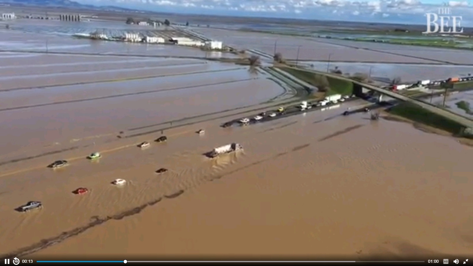
Here's a link to flooding and evacuation warning not connected to the dam. The
photo is about 50 miles southwest of Oroville. There's just a massive amount of water in that area. Very flat along the I-5 corridor. I can only
imagine trying to evacuate in a car only to run into roads covered in water.
Also in the article, fear from another dam further south having water run over its spillway, add to river water, causing flooding downstream in their area.
Also in the article, fear from another dam further south having water run over its spillway, add to river water, causing flooding downstream in their area.
Some of the concerns are due to the precariously full Don Pedro Reservoir, which captures water from the Tuolumne River, a key tributary of the San Joaquin.
The reservoir, which has more than twice the capacity of Folsom Lake, remained close to cresting Sunday. If it goes over the top of its spillway, it would send a gush of water that could overwhelm the small Tuolumne River channel, flood part of Modesto and cause the San Joaquin to rise.
originally posted by: desert
Here's a link to flooding and evacuation warning not connected to the dam. The photo is about 50 miles southwest of Oroville. There's just a massive amount of water in that area. Very flat along the I-5 corridor. I can only imagine trying to evacuate in a car only to run into roads covered in water.
Also in the article, fear from another dam further south having water run over its spillway, add to river water, causing flooding downstream in their area.
Some of the concerns are due to the precariously full Don Pedro Reservoir, which captures water from the Tuolumne River, a key tributary of the San Joaquin.
The reservoir, which has more than twice the capacity of Folsom Lake, remained close to cresting Sunday. If it goes over the top of its spillway, it would send a gush of water that could overwhelm the small Tuolumne River channel, flood part of Modesto and cause the San Joaquin to rise.
Exactly Why I tried to get you guys to refocus.
Thank You for this important update.
I took a screen shot of the video in your link
larger version underneath picture.
files.abovetopsecret.com...
MAXWELL
Forecasters with the National Weather Service offered a stark warning Sunday for just about everyone living in the soggy, soaked Central Valley.
“Pretty much anybody needs to be prepared for the possibility that they may have to evacuate quickly,” said Sacramento meteorologist Brooke Bingaman.
edit on 19-2-2017 by Reverbs because: (no reason given)
a reply to: Reverbs
Check out this video report for California
A video briefing from the National Weather Service,
which expects significant impact from Monday and Tuesday's storm.
The forecast includes flooding and strong winds in Northern and Central California.
National Weather Service Sacramento
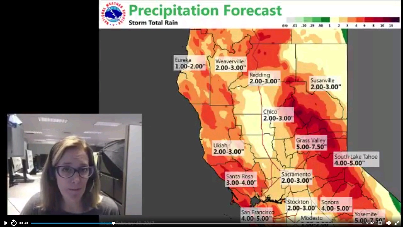
files.abovetopsecret.com...
Check out this video report for California
A video briefing from the National Weather Service,
which expects significant impact from Monday and Tuesday's storm.
The forecast includes flooding and strong winds in Northern and Central California.
National Weather Service Sacramento
files.abovetopsecret.com...
edit on 19-2-2017 by Reverbs because: (no reason given)
a reply to: Reverbs
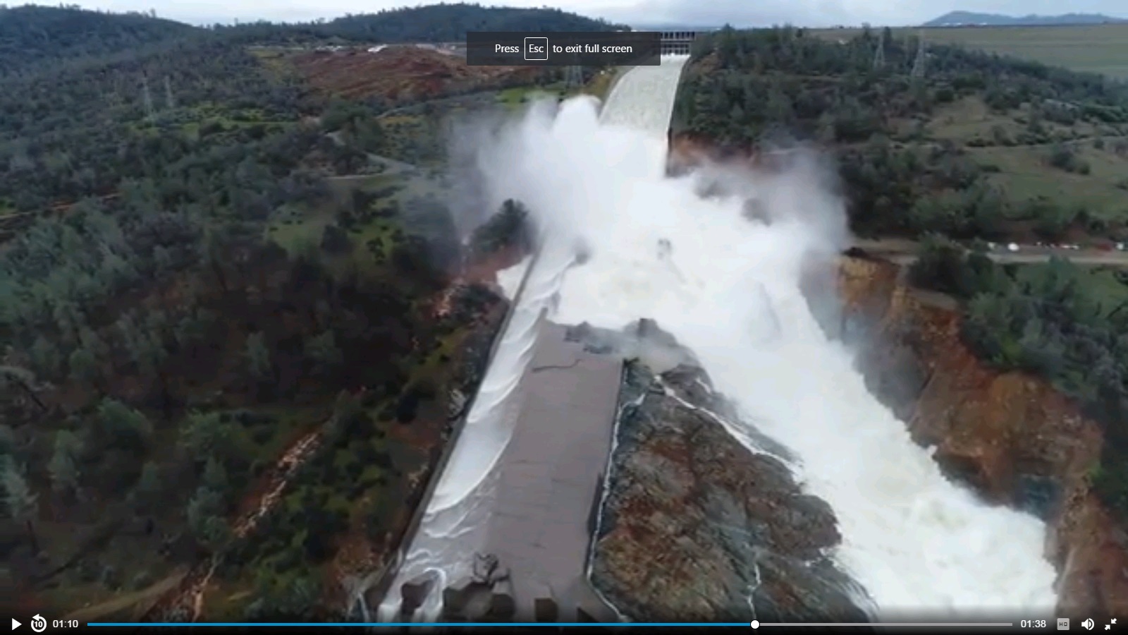
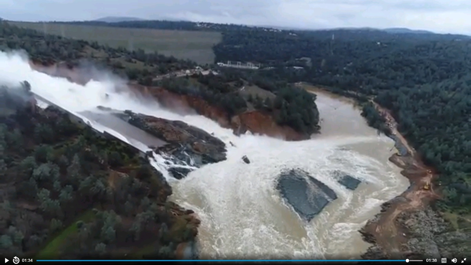
Here are some pics of Oroville Dam..
Larger versions underneath
the first two pics are the danger zone.. That is the emergency spill way wall, and spillway (dirt hillside now slightly covered in concrete/rocks)
You can see some water behind the wall inside the dam.
the third and fourth picture are of the Main spill way. You can see it's heavily damaged and created it's own channel throuh the ground and probably rock by the looks of it.
the actual Dam can be seen in the last picture as a light green wedge on the top of the screen. It's flow comes out behind the main spillway flow.. You can see the main spill way pushing debris and dirt towards the dam as well as away from it, so the dam power generator can not be turned back on yet until it's cleared.
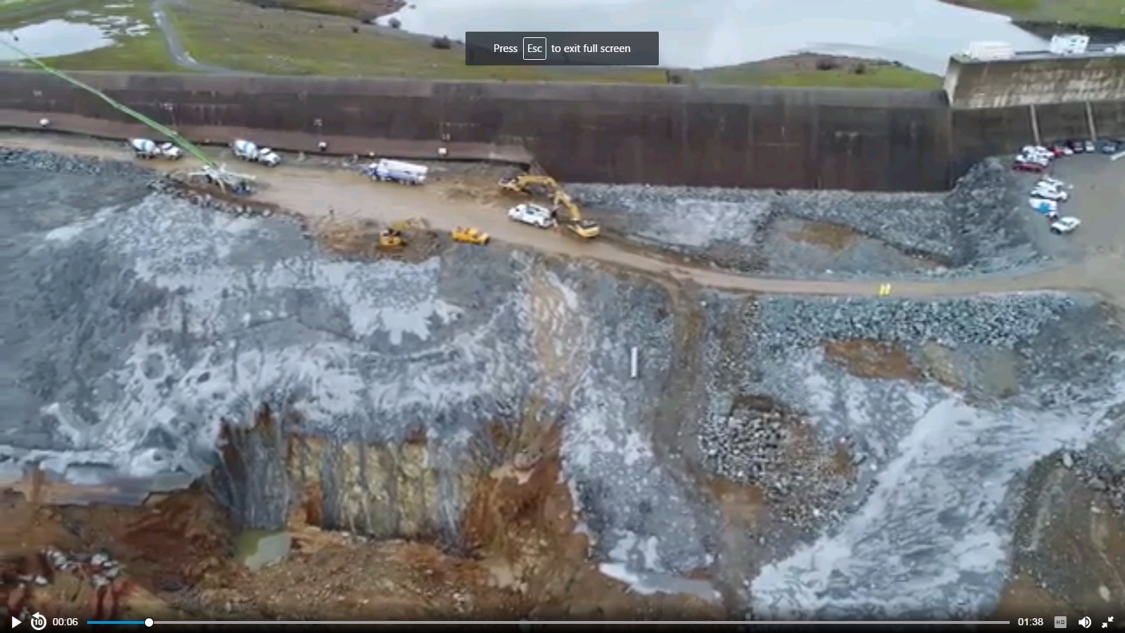
files.abovetopsecret.com...
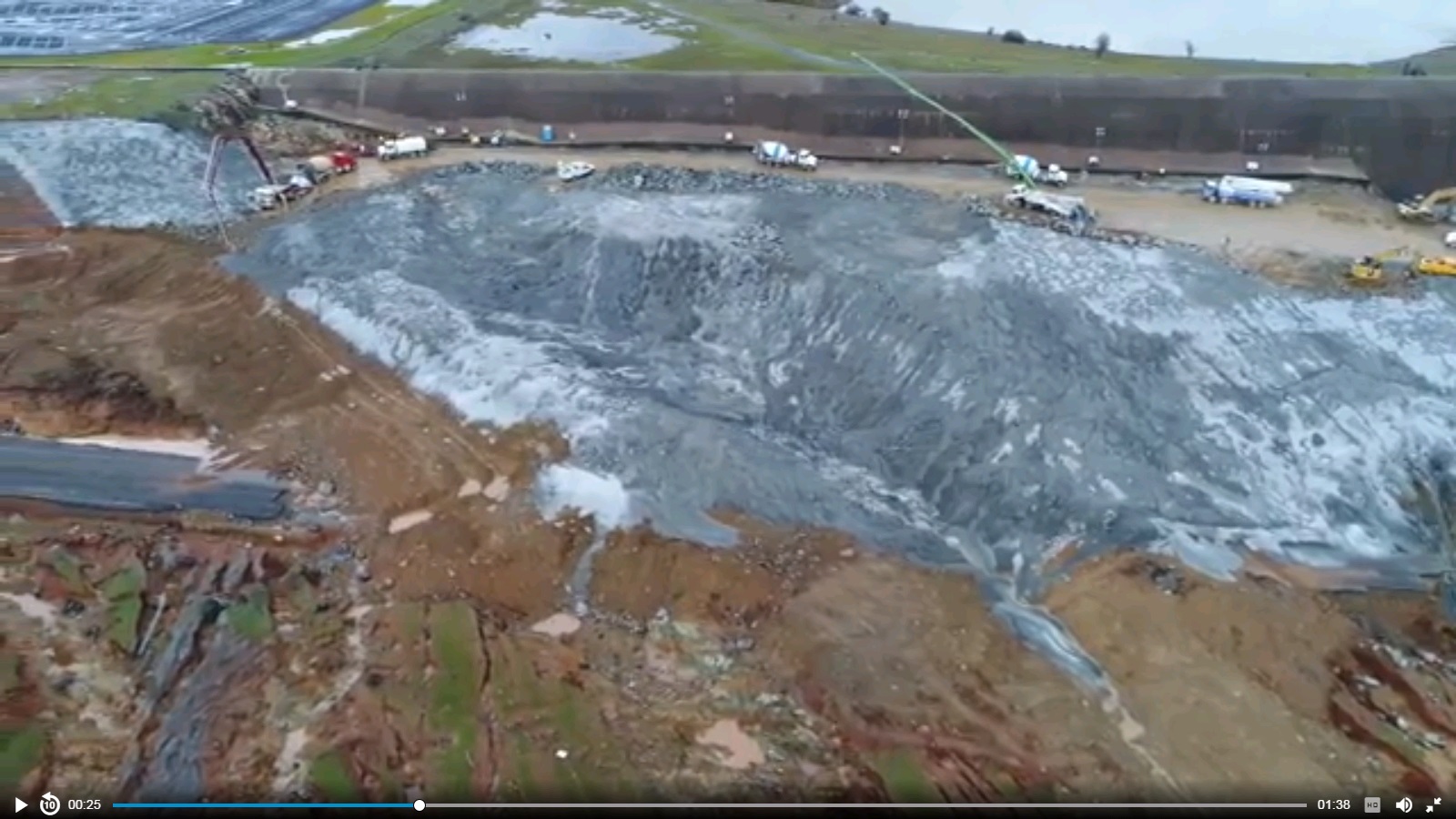
files.abovetopsecret.com...
files.abovetopsecret.com...
files.abovetopsecret.com...
Here are some pics of Oroville Dam..
Larger versions underneath
the first two pics are the danger zone.. That is the emergency spill way wall, and spillway (dirt hillside now slightly covered in concrete/rocks)
You can see some water behind the wall inside the dam.
the third and fourth picture are of the Main spill way. You can see it's heavily damaged and created it's own channel throuh the ground and probably rock by the looks of it.
the actual Dam can be seen in the last picture as a light green wedge on the top of the screen. It's flow comes out behind the main spillway flow.. You can see the main spill way pushing debris and dirt towards the dam as well as away from it, so the dam power generator can not be turned back on yet until it's cleared.
files.abovetopsecret.com...
files.abovetopsecret.com...
files.abovetopsecret.com...
files.abovetopsecret.com...
edit on 19-2-2017 by Reverbs because: (no reason given)
new topics
-
The Democrats Take Control the House - Look what happened while you were sleeping
US Political Madness: 13 minutes ago -
Sheetz facing racial discrimination lawsuit for considering criminal history in hiring
Social Issues and Civil Unrest: 18 minutes ago -
In an Historic First, In N Out Burger Permanently Closes a Location
Mainstream News: 2 hours ago -
MH370 Again....
Disaster Conspiracies: 2 hours ago -
Are you ready for the return of Jesus Christ? Have you been cleansed by His blood?
Religion, Faith, And Theology: 5 hours ago -
Chronological time line of open source information
History: 6 hours ago -
A man of the people
Diseases and Pandemics: 7 hours ago -
Ramblings on DNA, blood, and Spirit.
Philosophy and Metaphysics: 7 hours ago -
4 plans of US elites to defeat Russia
New World Order: 9 hours ago
top topics
-
Israeli Missile Strikes in Iran, Explosions in Syria + Iraq
World War Three: 16 hours ago, 17 flags -
In an Historic First, In N Out Burger Permanently Closes a Location
Mainstream News: 2 hours ago, 14 flags -
Thousands Of Young Ukrainian Men Trying To Flee The Country To Avoid Conscription And The War
Other Current Events: 12 hours ago, 7 flags -
Iran launches Retalliation Strike 4.18.24
World War Three: 15 hours ago, 6 flags -
A man of the people
Diseases and Pandemics: 7 hours ago, 4 flags -
4 plans of US elites to defeat Russia
New World Order: 9 hours ago, 4 flags -
12 jurors selected in Trump criminal trial
US Political Madness: 15 hours ago, 4 flags -
The Democrats Take Control the House - Look what happened while you were sleeping
US Political Madness: 13 minutes ago, 3 flags -
Chronological time line of open source information
History: 6 hours ago, 2 flags -
Are you ready for the return of Jesus Christ? Have you been cleansed by His blood?
Religion, Faith, And Theology: 5 hours ago, 2 flags
active topics
-
The Democrats Take Control the House - Look what happened while you were sleeping
US Political Madness • 1 • : Astrocometus -
Israeli Missile Strikes in Iran, Explosions in Syria + Iraq
World War Three • 81 • : CarlLaFong -
MH370 Again....
Disaster Conspiracies • 5 • : billxam1 -
SC Jack Smith is Using Subterfuge Tricks with Donald Trumps Upcoming Documents Trial.
Dissecting Disinformation • 99 • : matafuchs -
Are you ready for the return of Jesus Christ? Have you been cleansed by His blood?
Religion, Faith, And Theology • 15 • : 19Bones79 -
4 plans of US elites to defeat Russia
New World Order • 33 • : andy06shake -
12 jurors selected in Trump criminal trial
US Political Madness • 54 • : ImagoDei -
New Photo's reveal Railway System underneathe the Pyramids
Breaking Alternative News • 30 • : jshdnl -
Thousands Of Young Ukrainian Men Trying To Flee The Country To Avoid Conscription And The War
Other Current Events • 23 • : Consvoli -
Candidate TRUMP Now Has Crazy Judge JUAN MERCHAN After Him - The Stormy Daniels Hush-Money Case.
Political Conspiracies • 397 • : Threadbarer