It looks like you're using an Ad Blocker.
Please white-list or disable AboveTopSecret.com in your ad-blocking tool.
Thank you.
Some features of ATS will be disabled while you continue to use an ad-blocker.

BREAKING: Fearing collapse of emergency spillway at Oroville Dam, Oroville evacuated
page: 11share:
a reply to: Reverbs
Here is a link to real time (well, hourly) data from CA DWR:
Oroville Dam (ODO)
As of 5PM local, inflow is at 20,268 cfs and outlow at 99,914 cfs. Inflows will definitely increase in the next storm. At the peak of last week's storms the inflow maxed at 155,000 cfs. If that happens again this weekend then levels are going up because the primary can't go much past 100,000 cfs AFAIK. Best keep that Niagara sized faucet wide open.
today is wednesday it's supposed to rain thursday so If you guys could find a lake level update for me or in flows rate? that would be great. Last I checked the inflow was 20,000 cfs with out flow of 100,000 cfs giving us a drain of 80,000 cfs net. That's niagara falls level drainage.
Here is a link to real time (well, hourly) data from CA DWR:
Oroville Dam (ODO)
As of 5PM local, inflow is at 20,268 cfs and outlow at 99,914 cfs. Inflows will definitely increase in the next storm. At the peak of last week's storms the inflow maxed at 155,000 cfs. If that happens again this weekend then levels are going up because the primary can't go much past 100,000 cfs AFAIK. Best keep that Niagara sized faucet wide open.
originally posted by: Tripnman
a reply to: Reverbs
today is wednesday it's supposed to rain thursday so If you guys could find a lake level update for me or in flows rate? that would be great. Last I checked the inflow was 20,000 cfs with out flow of 100,000 cfs giving us a drain of 80,000 cfs net. That's niagara falls level drainage.
Here is a link to real time (well, hourly) data from CA DWR:
Oroville Dam (ODO)
As of 5PM local, inflow is at 20,268 cfs and outlow at 99,914 cfs. Inflows will definitely increase in the next storm. At the peak of last week's storms the inflow maxed at 155,000 cfs. If that happens again this weekend then levels are going up because the primary can't go much past 100,000 cfs AFAIK. Best keep that Niagara sized faucet wide open.
well if it happens again... That's a net of 55,000 in.. compared to us watching around a 80,000 net out for 3 days.. So it would have to have inflows like that for what 5 days well 4.7 days or something Random math in my head.. By then the emergency spillway can easily be reinforced enough to be usable.
I never focused too hard on the main dams power station outflow. I think it had mud or debri something needs to get cleaned out.. IT can add 10,000 cfs..
But yea I'm not worried about that part.
the rivers downstream there are 2 directly fed by this.
I wonder how full they are now.. When the lake was at max well over max capacity the rivers were half way to flood stage. But could take a lot more water.
I do think we might see some flooding and obviously if any levees give out we will.
a reply to: Reverbs
I live near one of those rivers and I can tell you that down here the Sacramento River is high, but holding. Last week we got to about 4' from flood stage.
The Feather, which connects to the Oroville outflow, connects to the Sacramento north of here. The levee systems throughout NorCal are being pushed to their limits. We've had some minor failures and there are a few spots they're worried about (like the Moke River you mentioned earlier and Tyler Island in Walnut Grove).
Since it is unlikely that we'll see any catastrophic failure at Oroville, I'm not concerned about river levels at the moment. If we're handling the 100,000 CFS currently, we'll keep handling it. That will change of course if a 30' wall of water heads this way. But down here we'd have at least 12 hours notice and it would be about 3" by the time it got here.
edit on 15-2-2017 by Tripnman because: Added note about flood stage in downtown Sac

originally posted by: Themaskedbeast
POST REMOVED BY STAFF
[snipped]
This is actually a serious topic. We should stay on it. At least a couple of the members here live in that area. One who was visually watching with his or her eyes..
So, let's stick to the data, and get it out and accurate to the timing.
If any of you notice changes. Look for changes in extra erosion, or heavier rain forecasts.. Please share that here.
The reason I came into this topic and stayed here. It was BAD... If they were 30 minutes.. An hour late with their turning on of the main spillway that was already damaged.. IF the evacuation was just 10 minutes later as this other thing took place.
This is a very serious issue.
I'm not trying to downplay it.
Once the people involved knew this was serious they took the correct moves. Was a close save just looking at it, without thinking of the numbers and extrapolating what that wall of water would have meant. The wall of water is no longer behind the wall for now.
edit on 15-2-2017 by Reverbs because: (no reason given)
edit on Wed Feb 15 2017 by DontTreadOnMe because: (no reason
given)
a reply to: Reverbs
pic
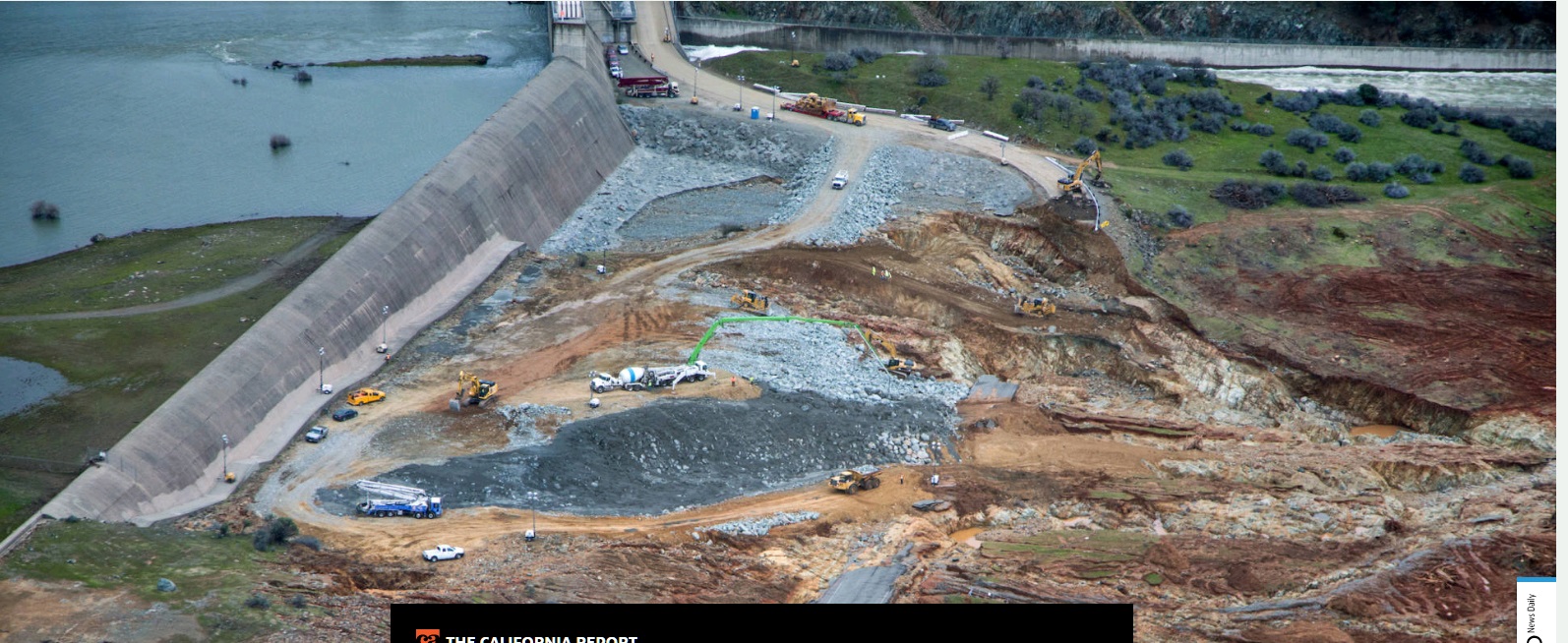
Oroville Update: Lake Continues to Fall as First Storm Arrives
pic
Update, 11:35 a.m. Thursday: The Feather River watershed has gotten its first dose of rain and snow from an expected series of storms, with moderate amounts of precipitation that haven’t yet caused a major increase in flows into the reservoir behind Oroville Dam.
For the 12 hours ending at 9 a.m., precipitation totals ranged from about a half-inch at the dam itself to 1.10 inches near Bucks Lake.
At the same time, the Department of Water Resources announced it was reducing flows down the dam’s main spillway as crews get ready to remove the large volume of debris that has fallen into the channel below.
Oroville Update: Lake Continues to Fall as First Storm Arrives
edit on 16-2-2017 by Reverbs because: (no reason given)
It will be another 12-24 hours before the rainfalls in the area will directly affect the dam as far as increasing levels. I am hopeful just like you
are...I just have family in the area as well as family that work for certain municipalities that would be directly affected by a breach.....
Keeping my fingers crossed over the next 7-10 days as they are nowhere close to in the clear..
Keeping my fingers crossed over the next 7-10 days as they are nowhere close to in the clear..
edit on 16-2-2017 by GuidedKill because: (no
reason given)
a reply to: GuidedKill
yea.. It looks like they increased the rainfall totals as well.. At least from what I saw a few days ago.
yea.. It looks like they increased the rainfall totals as well.. At least from what I saw a few days ago.
edit on 16-2-2017 by Reverbs because: (no reason given)
a reply to: Reverbs
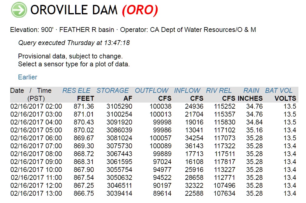
This guy has good information. It's from this morning. 9:30am eastern time
This shows in flows and outflows. Lake level lake capacity.
You can see they lowered the outflow from 100,000 cfs to 90,000 cfs.
full size image
Source
I'd like to point out that I was going off lake levels they claimed they would reach by today. They claimed to be shooting for 88 feet lower than the 900 feet when it's full. Well if you click on the picture link you will see in the last line that data is from 1:00pm pacific time. 88 feet from 900 would have been 812 feet in the lake.. Well, that number as of 50 minutes ago is actually 866.7 feet.
You can also see rain totals at the dam. So today so far it looks like a half inch of rain.
What I'm seeing is that they don't expect the inflow to top 40,000 cfs and so will be reducing outflow as well to reduce stress on the main spillway.
The in flows that got us into this mess were 150,000 cfs to maybe even 200,000 cfs.. So 40,000 cfs if true, and I'm seeing not to necessarily trust anything I read until it happens.. If that's true that's easily manageable.
the drop in water level is varying from 1/4 to 1/2 foot per hour each hour today.
Outflow reduced at main spillway to 85,000 cfs as of just now.
that data is updated every hour on the hour.
edit on 16-2-2017 by Reverbs because: (no reason given)
a reply to: Reverbs
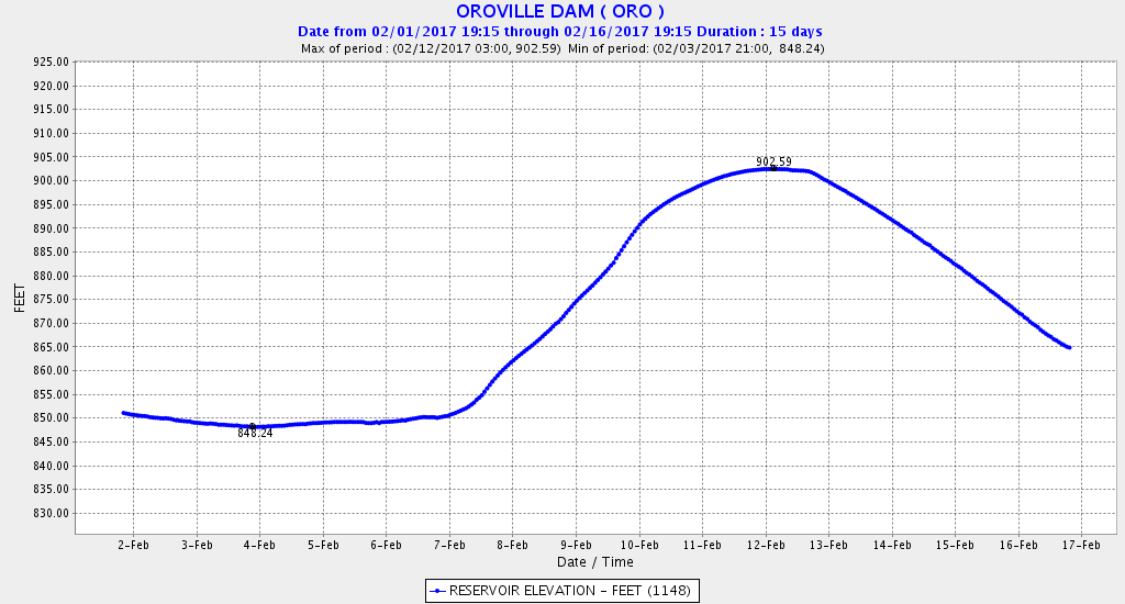
Water level at lake. February 1st to now
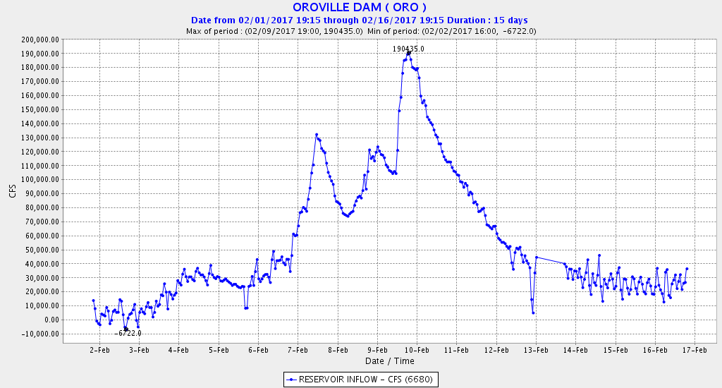
Water in flow at the lake. February 1st to now
Water out flow at the lake. February 1st to now
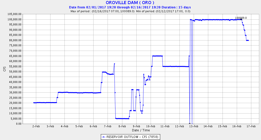
I hope this gives a good idea.
Source
You can make your own graphs for any time tables or data you want from that site. You can monitor not only this dam but maybe you want to see the Shasta dam? it's there too.. just click the top of any column and that will go to the graph then select the time range.. So in the water level column at the top it will say water level above sea level or something click that and you can re make my same top graph there for yourself if you like.
plying with the data on your own might help you be confident in what it is I've been saying.
So yea I guess the latest takeaway here is the lake is down to 865 feet, and it's still draining at 80,000 cfs from the main spillway, down from 100,000 cfs.
Water level at lake. February 1st to now
Water in flow at the lake. February 1st to now
Water out flow at the lake. February 1st to now
I hope this gives a good idea.
Source
You can make your own graphs for any time tables or data you want from that site. You can monitor not only this dam but maybe you want to see the Shasta dam? it's there too.. just click the top of any column and that will go to the graph then select the time range.. So in the water level column at the top it will say water level above sea level or something click that and you can re make my same top graph there for yourself if you like.
plying with the data on your own might help you be confident in what it is I've been saying.
So yea I guess the latest takeaway here is the lake is down to 865 feet, and it's still draining at 80,000 cfs from the main spillway, down from 100,000 cfs.
edit on 16-2-2017 by Reverbs because: (no reason given)
a reply to: Reverbs
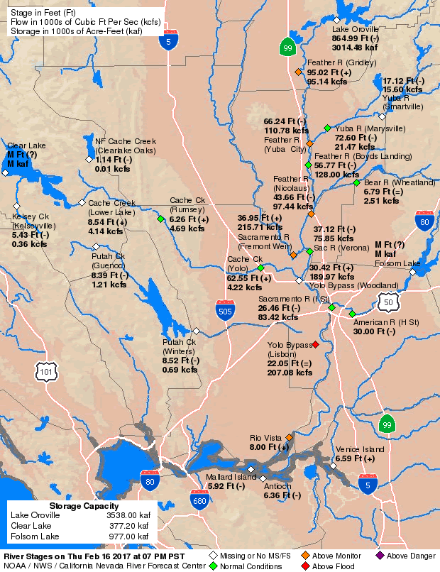
larger image
That's a map of rivers and lakes.
the information on it is as such.
the diamonds are monitoring stations. The color code is:
Green = normal
Orange = above normal
Red = above flood level
Purple = above danger
at the top right is lake oroville and the oroville dam
feather river comes out of that lake. The following monitoring stations are on feaather river downstream from oroville lake.
The Gridley Nicolaus and Yuba city monitors are orange or above normal.
The Verona, and Boyds landing monitoring sites are green or normal level.
most all of the other monitoring stations are at normal levels.
originally posted by: Mousygretchen
a reply to: Reverbs
The crucial space is between Yuba city and Gridley, obviously.
Watch the Yuba City monitoring station...
I'm actually looking at floods for any area as the flow from the lake has been decreased by 20,000 cfs.
The dam is not in danger as I was saying earlier, so I've moved to looking at the surrounding rivers.
Everything is showing good news.
And yes you are right, and both of those stations are over normal levels, but now the water coming in is less than it was before.
of course the rain today was also only .5 to 1 inches depending on where you look.
obviously as it gets warmer and more snow melts it could get back into danger zone especially if it coincides with rain.
So just watching for the sake of ATS intel.
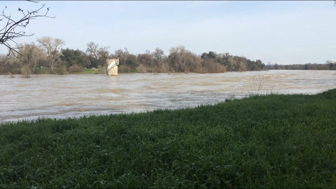
originally posted by: Reverbs
a reply to: LadyGreenEyes
Your picture is of the 2 spillways neither is the Dam which is much larger and to the right out of frame.
You don't even know what you are looking at.
This is the problem. The news confused two elements again and again..
there is no erosion at the spillway that is a 30 foot wall. No current erosion.
It's not safe to use theat spillway and obviously they won't until a huge fix is made..
Point is they expect to get the lake down 80 feet and the water wont even be up to the wall in the first place.
I bet you'll see the evacuations ceased in 1-2 days.
the flash flood warnings are about to expire and they didn't renew them. (those were for the 30 foot wall possibly collapsing)
unless you guys are expecting 700 feet of earth and concrete to just disappear for no reason. (main spillway )
you'll see soon enough.
I'd bet you $1000 dollars if I had it.
I don't see you posting any pics. Feel free.
No one said anything about a thirty-foot wall eroding. What was said was that a break could result in a thirty-foot wall of WATER. What was that about me being confused??
Experts in dam engineering are concerned, but if you want to pretend there is no reason, go right ahead. The levees in New Orleans were safe, too. Glacier 511 wasn't going to fall. There wouldn't be a devastating quake in Japan, to threaten nuclear plants. There was no need to make safer buildings in Haiti, because of quake worries. Just relax. Dams never, ever, fail.
originally posted by: antar
a reply to: LadyGreenEyes
Thanks for the update and thread.
Also has anyone discussed Gov Brown and how he is taking action or not? I last heard he was very busy getting "funding" and back up plans of National guard etc. in place, but not really releasing info to the public?
Also how are the evacuations going? gas stations ran out last I heard and some looting began last night?
Just now jumping in to find out some info. Also is there a list of the affected towns and cities in worst case scenario? Has anyone talked about displacement pressure that could cause a major earthquake? Although the dam is well over due for upgrades and repairs, how close was the nearest fracking operation to the dam?
That dam really worries me. Has since I read that bit from the LinkedIn contact. Then, with evacuations, etc, that feeling grew! No idea what their useless governor is doing; whatever he thinks looks good seems likely.
I heard conflicting reports on looting. Some claims there was some, ten other claims there wasn't, at least in some areas. I got the distinct impression they were trying to downplay that. Can't believe they have people back already, all considered. Ten inches of rain expected now, too - source - which, when added to the snow melt, is quite a lot. Who knows how their repairs will hold up!?
Ah, quake possibilities. Yeah, that has to be considered. I read the dam sits right on a fault line. Great planning, eh??
originally posted by: LadyGreenEyes
originally posted by: Reverbs
a reply to: LadyGreenEyes
Your picture is of the 2 spillways neither is the Dam which is much larger and to the right out of frame.
You don't even know what you are looking at.
This is the problem. The news confused two elements again and again..
there is no erosion at the spillway that is a 30 foot wall. No current erosion.
It's not safe to use theat spillway and obviously they won't until a huge fix is made..
Point is they expect to get the lake down 80 feet and the water wont even be up to the wall in the first place.
I bet you'll see the evacuations ceased in 1-2 days.
the flash flood warnings are about to expire and they didn't renew them. (those were for the 30 foot wall possibly collapsing)
unless you guys are expecting 700 feet of earth and concrete to just disappear for no reason. (main spillway )
you'll see soon enough.
I'd bet you $1000 dollars if I had it.
I don't see you posting any pics. Feel free.
No one said anything about a thirty-foot wall eroding. What was said was that a break could result in a thirty-foot wall of WATER. What was that about me being confused??
Experts in dam engineering are concerned,
check my pictures at the beginning of the thread I even circled areas to make things easy on you guys.
Yes you are still confused the 30 foot wall of water comes from a 30 foot wall failing. That's EXACTLY where they got that number. How do I know that.. They told me that at least 100 times over the last week or so. I'm actually a smart guy and paying attention..
Have you not noticed everything I've said has come true?
I edited off your off topic part about things go wrong..
There is no longer any water or water pressure on that wall.. So what force is going to act on it to make it fail?
Answer me that.
Or are you still confused thinking the main spillway is in danger somehow? The problem is the Emergency spillway.. The main spillway erosion is not making a head cut in any longer and hasn't for days now. It's also like 700 feet away from anything super critical.
And if you read the graphs you will see why I'm not screaming Doom! loud enough for you. I have real concerns to I'm just more high information. If you just took the time instead of listening to people that have not taken the time, you'd be better off.
I don't need to read how you feel..
Let's see some data and your understanding of it..
For instance the wall getting undermined is EXACTLY what the issue could have been, which is EXACTLY why they have poured all that concrete in that EXACT area..
Don't get petty with me..
I've been right about everything. I even hit the evacuation order being canceled right on..
I gave youa site to monitor the data at the dam. At what level of water in feet above sea level does the emergency spillway start to be underwater? And at what level will it be overtopped and risk further erosion of the side of the hill?
do you know ? Or throughout today do you know when it rained or how much? Do you know the projected inflows? And the goal set for lake height? Do you know the exact damaged areas and what makes them dangerous and their distance from water load bearing structures?
I do..
This video is a accurate view of what all is going down.
see the road in the youtube preview? it's in like 5 pieces? That was some intense erosion and without that erosion no one would have ever heard of this dam. That's why a normal situation all the sudden went to critical danger! Well that critical danger has passed.. I'm not saying the problem is fixed, but while it's being fixed for now it's in stable condition. There is no water force that can change that until water levels go upwards of 901 feet above sea level. They are at 865 last time I looked.
edit on 17-2-2017 by Reverbs because: (no reason given)
edit on 17-2-2017 by Reverbs because: (no reason given)
originally posted by: LadyGreenEyes
Can't believe they have people back already, all considered. Ten inches of rain expected now, too - source - which, when added to the snow melt, is quite a lot. Who knows how their repairs will hold up!?
Ah, quake possibilities. Yeah, that has to be considered. I read the dam sits right on a fault line. Great planning, eh??
the conflicting reports on the looting is because there was some crime but it was like individuals no widespread looting or rioting.. Know what I mean? I bet not many even saw it.
This link you gave is data and that's what we need in this thread.
Today there was aroud an inch of rain.. 10 inches is quite a different story.
by let's make this up in my head by this time tomorrow the lake should be 854 feet above sea level, giving it a space of about 50 feet to fill.
I'd have to do some math to imagine if that would be able that 10 inches would be able to fill that last 50 feet and then over top the emergency spill way.
That is a huge danger if it can overtop, but I'm not forecasting that.
Currently we are holding at around 30,000 cfs in flow into the lake.
They are holding the main spillway at 80,000 cfs down from 100,000 cfs.
That still gives us a net drain of 50,000 cfs.. For reference as shown to me earlier in this thread niagara falls is 84,000 cfs.
so look the point of the dam. It's supposed to be flood control.. The danger is in not being able to use it as flood control .. idealy you want to hold water in the lake and only outflow what the rivers can take hoping the lake won't fill up in the process.
because of what happened and the lake being over full they had to just drain it as fast as possible without the ability to consider river levels..
So I havn't checked the other dams in the area like Shasta. I'll do that in a bit. If they all have room then the rain might not make the rivers flood.. but if they all have to release a lot of water it's going to spell trouble and at the moment the trouble is going to be further south than near the dams.
edit on 17-2-2017 by Reverbs because: (no reason given)
new topics
-
Electrical tricks for saving money
Education and Media: 1 hours ago -
VP's Secret Service agent brawls with other agents at Andrews
Mainstream News: 2 hours ago -
Sunak spinning the sickness figures
Other Current Events: 3 hours ago -
Nearly 70% Of Americans Want Talks To End War In Ukraine
Political Issues: 3 hours ago -
Late Night with the Devil - a really good unusual modern horror film.
Movies: 5 hours ago -
Cats Used as Live Bait to Train Ferocious Pitbulls in Illegal NYC Dogfighting
Social Issues and Civil Unrest: 6 hours ago -
The Good News According to Jesus - Episode 1
Religion, Faith, And Theology: 8 hours ago -
HORRIBLE !! Russian Soldier Drinking Own Urine To Survive In Battle
World War Three: 10 hours ago
top topics
-
SETI chief says US has no evidence for alien technology. 'And we never have'
Aliens and UFOs: 17 hours ago, 8 flags -
Cats Used as Live Bait to Train Ferocious Pitbulls in Illegal NYC Dogfighting
Social Issues and Civil Unrest: 6 hours ago, 8 flags -
Florida man's trip overseas ends in shock over $143,000 T-Mobile phone bill
Social Issues and Civil Unrest: 13 hours ago, 8 flags -
VP's Secret Service agent brawls with other agents at Andrews
Mainstream News: 2 hours ago, 7 flags -
Former Labour minister Frank Field dies aged 81
People: 15 hours ago, 4 flags -
Bobiverse
Fantasy & Science Fiction: 13 hours ago, 3 flags -
HORRIBLE !! Russian Soldier Drinking Own Urine To Survive In Battle
World War Three: 10 hours ago, 3 flags -
Nearly 70% Of Americans Want Talks To End War In Ukraine
Political Issues: 3 hours ago, 3 flags -
Sunak spinning the sickness figures
Other Current Events: 3 hours ago, 3 flags -
Late Night with the Devil - a really good unusual modern horror film.
Movies: 5 hours ago, 2 flags
active topics
-
The Reality of the Laser
Military Projects • 45 • : 5thHead -
President BIDEN Vows to Make Americans Pay More Federal Taxes in 2025 - Political Suicide.
2024 Elections • 125 • : ImagoDei -
Cats Used as Live Bait to Train Ferocious Pitbulls in Illegal NYC Dogfighting
Social Issues and Civil Unrest • 13 • : Albone -
Spectrophilia - Women Who Have Had Affairs With Ghosts Say Spooks Are Better Lovers Than Real Men
Paranormal Studies • 31 • : charlyv -
HORRIBLE !! Russian Soldier Drinking Own Urine To Survive In Battle
World War Three • 29 • : doubledan717 -
-@TH3WH17ERABB17- -Q- ---TIME TO SHOW THE WORLD--- -Part- --44--
Dissecting Disinformation • 651 • : 777Vader -
VP's Secret Service agent brawls with other agents at Andrews
Mainstream News • 19 • : NoCorruptionAllowed -
VirginOfGrand says hello
Introductions • 5 • : burritocat -
SETI chief says US has no evidence for alien technology. 'And we never have'
Aliens and UFOs • 42 • : Boomer1947 -
NASA Researchers Discover a Parallel Universe That Runs Backwards through Time - Alongside Us
Space Exploration • 71 • : charlyv