It looks like you're using an Ad Blocker.
Please white-list or disable AboveTopSecret.com in your ad-blocking tool.
Thank you.
Some features of ATS will be disabled while you continue to use an ad-blocker.

BREAKING: Fearing collapse of emergency spillway at Oroville Dam, Oroville evacuated
page: 14share:
a reply to: Reverbs
That's a good screen shot. That's interstate Hwy 5, the major north-south artery up in that part of CA. Yikes! ATS members who have traveled on it remember it without the water!
Oh, I forgot this part of the article re Oroville Dam
I was hoping the power plant restart would be sooner, but at least once it starts they can have more water go out. There should be no worry as long as the water level stays below the lip of the spillway, and they're working at keeping it that way. That CDEC link for the lake water level has been reassuring to watch. I bookmarked it, as, depending on future weather, the rest of the rain season good be interesting.
That's a good screen shot. That's interstate Hwy 5, the major north-south artery up in that part of CA. Yikes! ATS members who have traveled on it remember it without the water!
Oh, I forgot this part of the article re Oroville Dam
Once the debris is cleared and the power plant is restarted, the facility is capable of draining another 14,000 cfs from the lake.
“We’re shooting to be able to re-operate it a week from Monday if we need to,” said Chris Orrock, a spokesman for the Department of Water Resources, which manages the dam. But he noted “it’s not a guaranteed date.” Meanwhile, despite the wet weather, crews continue to haul rock and cement into the eroded areas below the emergency spillway in case it should need to be used again.
I was hoping the power plant restart would be sooner, but at least once it starts they can have more water go out. There should be no worry as long as the water level stays below the lip of the spillway, and they're working at keeping it that way. That CDEC link for the lake water level has been reassuring to watch. I bookmarked it, as, depending on future weather, the rest of the rain season good be interesting.
a reply to: desert
yea they started clearing debris a few days ago but I'm thinking it will be weeks for that to turn on..
They re wired the lines though.
so that's one step..
I actually just posted about why it's turned off in my last post with all the pictures
I now have the larger version of all the pics underneath including the first screen shot.
And yes cannot wait for that to get turned back on. At first they were quoting 12,000 cfs, but now I'm hearing more often 14,000 cfs.. That would be a Huge help..
edit on 19-2-2017 by Reverbs because: (no reason given)
a reply to: Reverbs
Pix and comment
All this dam work up and down the state is noted in normal/dry years, put on hold or vetoed, then we get a rainy season like this. Reminds me of people who get leaks in their roof when it rains, swearing to fix it, then do nothing when the rain stops. I think Oroville has put dam discussion back in the forefront. It will require $$.
At the southern end of the Central Valley, Congressman McCarthy issued a statement on the dam in his district. The work on it is a major project. Years of work.
Congressman Kevin McCarthy releases statement on Lake Isabella, safety
One thing good, dam releases can recharge ground water, which is needed after the drought years and increasing usage.
originally posted by: dianajune
originally posted by: Reverbs
a reply to: dianajune
Oroville Dam is at 851 feet still dropping, but that should change soon only 1/4 inch of rain at the dam site in the last 12 hours.
That's good. According to the following link, it's now 850.74
Source
850.60 !!
I feel like I'm watching the ball drop.. This is actually much more exciting and satisfying.
a reply to: Reverbs
This is from an angle that makes it look from inside the Dam. It's coming from where the dam is looking all the way across to the dam to the emergency spill way. So that's the inside of the spillway wall.
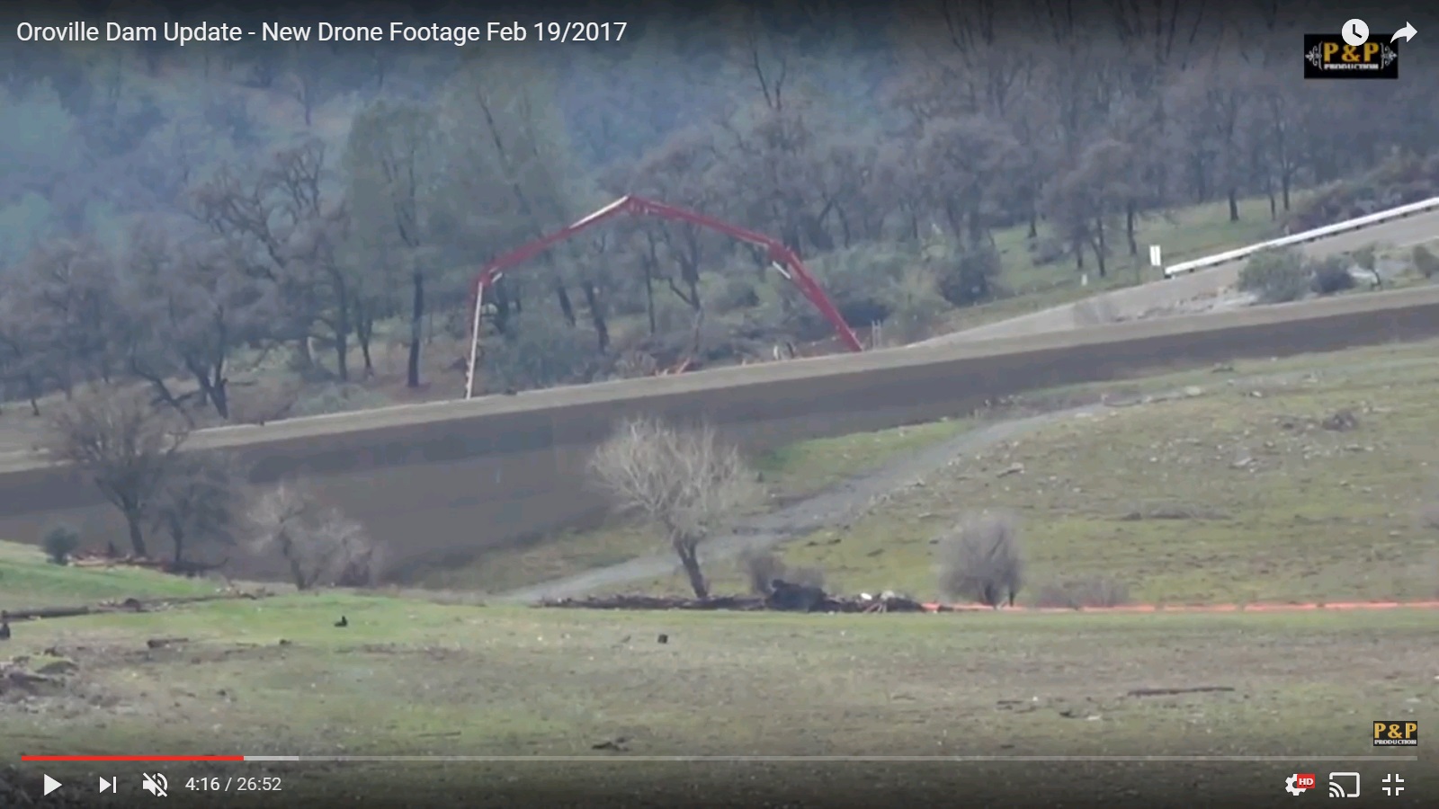
files.abovetopsecret.com...
Similar view this time you see what the Dam itself looks like. Basically a slanted rocky hill.
THe emergency spill way again is that dark colored wall. Doesn't look like much but remember these are huge scales it's 30 feet tall.
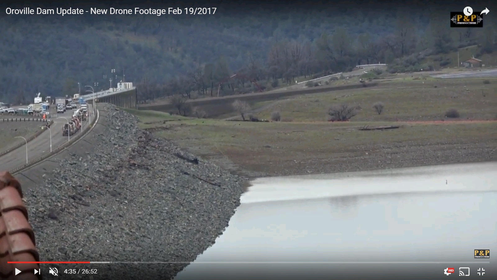
files.abovetopsecret.com...
Here is the main spill way from the side to give a better idea
files.abovetopsecret.com...
This is in the general area but I can't know where. I imagine that's not supposed to be water there.
files.abovetopsecret.com...
That road is definitely NOT passable.

files.abovetopsecret.com...
This is the same road in the picture above but the camera guy zoomed in so I thought I'd show you guys the flood level there.
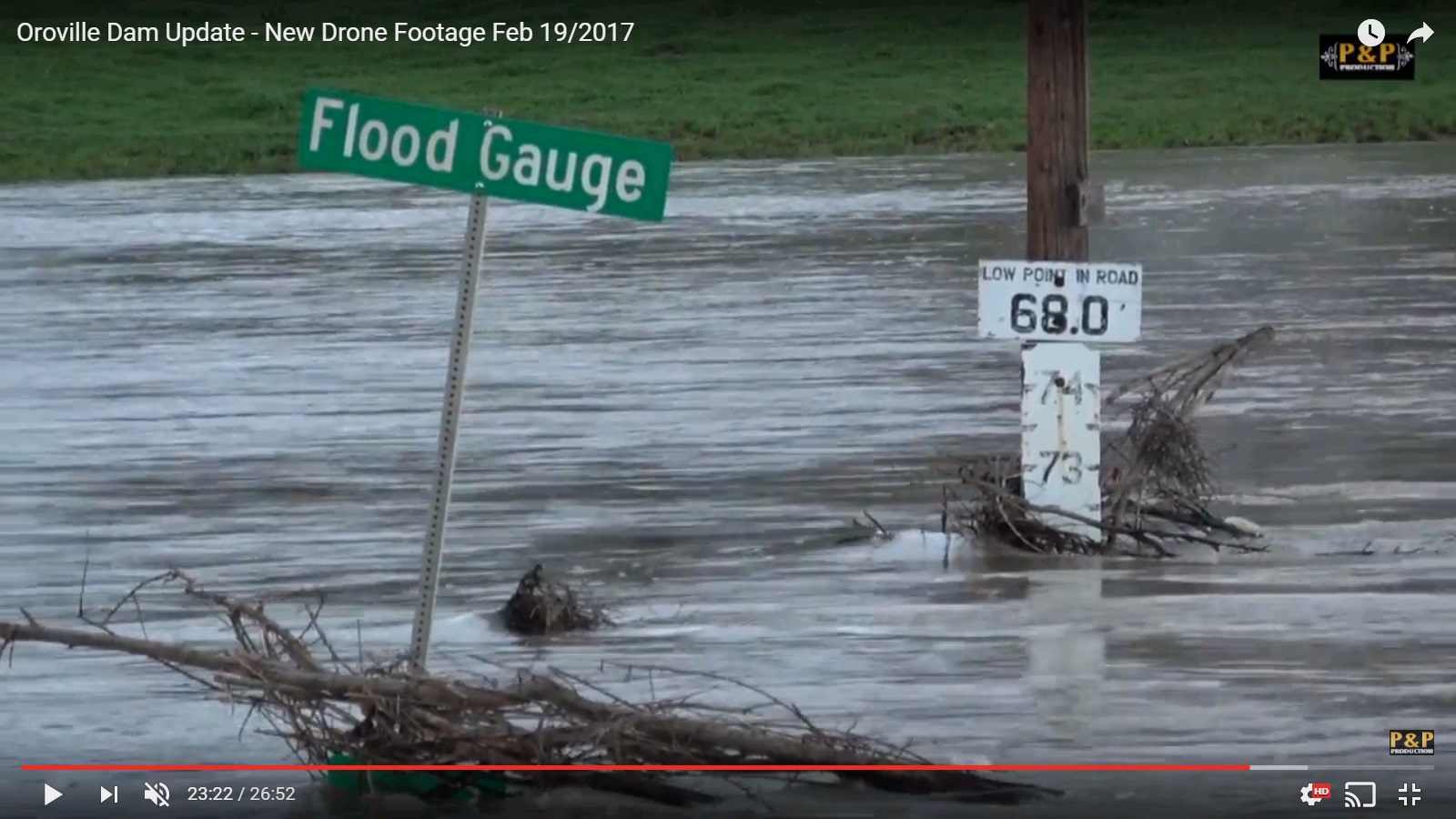
files.abovetopsecret.com...
This was hard to catch but basically they are driving through water.. I had no idea what was going on at first, but it's like the emergency vehicle was showing people you can make it through certain areas, like shepherd cars..
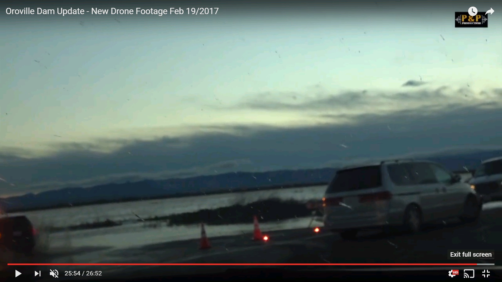
files.abovetopsecret.com...
These are from Sunday morning 8:00am pacific time.
I grabbed them from this video I posted earlier.
Update Oroville Dam 2/19/2017
I hope those pictures told a story.
This is from an angle that makes it look from inside the Dam. It's coming from where the dam is looking all the way across to the dam to the emergency spill way. So that's the inside of the spillway wall.
files.abovetopsecret.com...
Similar view this time you see what the Dam itself looks like. Basically a slanted rocky hill.
THe emergency spill way again is that dark colored wall. Doesn't look like much but remember these are huge scales it's 30 feet tall.
files.abovetopsecret.com...
Here is the main spill way from the side to give a better idea
files.abovetopsecret.com...
This is in the general area but I can't know where. I imagine that's not supposed to be water there.
files.abovetopsecret.com...
That road is definitely NOT passable.
files.abovetopsecret.com...
This is the same road in the picture above but the camera guy zoomed in so I thought I'd show you guys the flood level there.
files.abovetopsecret.com...
This was hard to catch but basically they are driving through water.. I had no idea what was going on at first, but it's like the emergency vehicle was showing people you can make it through certain areas, like shepherd cars..
files.abovetopsecret.com...
These are from Sunday morning 8:00am pacific time.
I grabbed them from this video I posted earlier.
Update Oroville Dam 2/19/2017
I hope those pictures told a story.
edit on 20-2-2017 by Reverbs because: (no reason given)
a reply to: Reverbs
About an inch of rain in the last 12 hours.
water levels at the Lake are Still Dropping.
We just dipped below 850, to 840.7 feet above sea level.
In flows are variable but I'd say around 40,000 cfs
and the outflow has been kept at 60,000 cfs.
If you're in the Valley in California Keep an eye out all day.
Today and Tomorrow should be a bit wet.
Thanks for the update and thread.
So I posted this a week ago and was "razzed" for having connected the Dam, the incoming storms and the vulnerability of major EQs in conjunction, NOW seems all that has changed. Do not recall who jumped me for my "Stretch" but if you check my posting history, although I do not claim to be anything special, psychic, a remote viewer or the likes, my track record is more than extraordinary. Not at all bragging here just wanted to Discuss with members who are truly enlightened on the subject of Faultlines and EQ's, when I got jumped, it never got to that point.
Also has anyone discussed Gov Brown and how he is taking action or not? I last heard he was very busy getting "funding" and back up plans of National guard etc. in place, but not really releasing info to the public?
Also how are the evacuations going? gas stations ran out last I heard and some looting began last night?
Just now jumping in to find out some info. Also is there a list of the affected towns and cities in worst case scenario? Has anyone talked about displacement pressure that could cause a major earthquake? Although the dam is well over due for upgrades and repairs, how close was the nearest fracking operation to the dam?
So I posted this a week ago and was "razzed" for having connected the Dam, the incoming storms and the vulnerability of major EQs in conjunction, NOW seems all that has changed. Do not recall who jumped me for my "Stretch" but if you check my posting history, although I do not claim to be anything special, psychic, a remote viewer or the likes, my track record is more than extraordinary. Not at all bragging here just wanted to Discuss with members who are truly enlightened on the subject of Faultlines and EQ's, when I got jumped, it never got to that point.
a reply to: antar
My track record in this thread is 100%
I'm also psychic a lot of the time.
I've touched on most of those points.
some people stole some things, but only a few people would call it looting. Pretty isolated incidents.
Federal Funding was granted by Trump as per Governors request.
gas ran out because everyone evacuated all at once with no prior warning.
The California Guard was on standby. As well as high speed water rescue and lots of choppers.
They did say all of that if anyone was paying attention like I was.
it's not on ongoing string of events that are all one thing. Emotions connect everything together..
for instance people think because they all evacuated instantly that no one at the dam was paying close enough attention. Well, no.. A very specific thing changed and when it was seen what was changing they rightly didn't take any chances and got everyone out..
the way that was reported people thought the Dam was damaged and it was going to fail. Well, no.. the were big holes in the dirt creeping back to the wall.. if those undercut the wall all the way across the wall could have tumbled over..
the wall was never damaged. I show it in that last batch of pictures. IT's the dark olive green colored wall on the right.
it's 30 feet tall and 1700 feet long. Another member kindly posted models or simulations of that wall collapsing and releasing a 30 foot wall of water.
It basically murders entire towns.. (not if it magically collapsed right now as the water level is 20 feet below the base of the wall)
No one would lift evacuation orders if that was still a concern.. So people get confused thinking but it was imminent?!! it must still be weak!! WEll, it was never weak, just let me think of analaogy.. A baby is almost bitten by a snake.. it was imminent.. but the baby was pulled away. That baby is not 75% poisoned on it's death bed nearly imminent .. It's completely safe and healthy almost died.. Huge difference.
No quakes reported at the Dam..
I'd almost expect people interested in quakes who are psychic and worried to be monitoring quake sites.
Like if they cared as much as me and were so worried why are you not sounding the alarm on quakes?
Trying to act like I don't care, that I was wrong somewhere?
Check out my track record.. I've made multiple predictions that all came true, I was also the only person in this thread describing the damage correctly.
No it has not changed. What makes you think that changed?
I'm telling you guys to stop chasing ghosts and look at the Ogre bearing down on California.
I know I'm not super fun in this thread.
It's something that has changed in me.
When something is this serious I'm not going to let people lose track of what really matters.
Even if it means I have to come off "mean"
the water level at the Lake is 849
My track record in this thread is 100%
I'm also psychic a lot of the time.
I've touched on most of those points.
some people stole some things, but only a few people would call it looting. Pretty isolated incidents.
Federal Funding was granted by Trump as per Governors request.
gas ran out because everyone evacuated all at once with no prior warning.
The California Guard was on standby. As well as high speed water rescue and lots of choppers.
They did say all of that if anyone was paying attention like I was.
it's not on ongoing string of events that are all one thing. Emotions connect everything together..
for instance people think because they all evacuated instantly that no one at the dam was paying close enough attention. Well, no.. A very specific thing changed and when it was seen what was changing they rightly didn't take any chances and got everyone out..
the way that was reported people thought the Dam was damaged and it was going to fail. Well, no.. the were big holes in the dirt creeping back to the wall.. if those undercut the wall all the way across the wall could have tumbled over..
the wall was never damaged. I show it in that last batch of pictures. IT's the dark olive green colored wall on the right.
it's 30 feet tall and 1700 feet long. Another member kindly posted models or simulations of that wall collapsing and releasing a 30 foot wall of water.
It basically murders entire towns.. (not if it magically collapsed right now as the water level is 20 feet below the base of the wall)
No one would lift evacuation orders if that was still a concern.. So people get confused thinking but it was imminent?!! it must still be weak!! WEll, it was never weak, just let me think of analaogy.. A baby is almost bitten by a snake.. it was imminent.. but the baby was pulled away. That baby is not 75% poisoned on it's death bed nearly imminent .. It's completely safe and healthy almost died.. Huge difference.
No quakes reported at the Dam..
I'd almost expect people interested in quakes who are psychic and worried to be monitoring quake sites.
Like if they cared as much as me and were so worried why are you not sounding the alarm on quakes?
Trying to act like I don't care, that I was wrong somewhere?
Check out my track record.. I've made multiple predictions that all came true, I was also the only person in this thread describing the damage correctly.
"razzed" for having connected the Dam, the incoming storms and the vulnerability of major EQs in conjunction, NOW seems all that has changed.
No it has not changed. What makes you think that changed?
I'm telling you guys to stop chasing ghosts and look at the Ogre bearing down on California.
I know I'm not super fun in this thread.
It's something that has changed in me.
When something is this serious I'm not going to let people lose track of what really matters.
Even if it means I have to come off "mean"
the water level at the Lake is 849
edit on 20-2-2017 by Reverbs because: (no reason given)
originally posted by: antar
Thanks for the update and thread.
If you are really interested in what's going on I've watched maybe every oroville video on youtube.
Almost all of it is BS from people who have no clue.
Some of it is extremely dangerous fear mongering from assholes.
Most of the "live" feeds are NOT live so that's an issue as well.
There are some videos today none of which are good for you to watch.. That I've found so far.
I posted this way back at the beginning of this thread. It bears repeating.
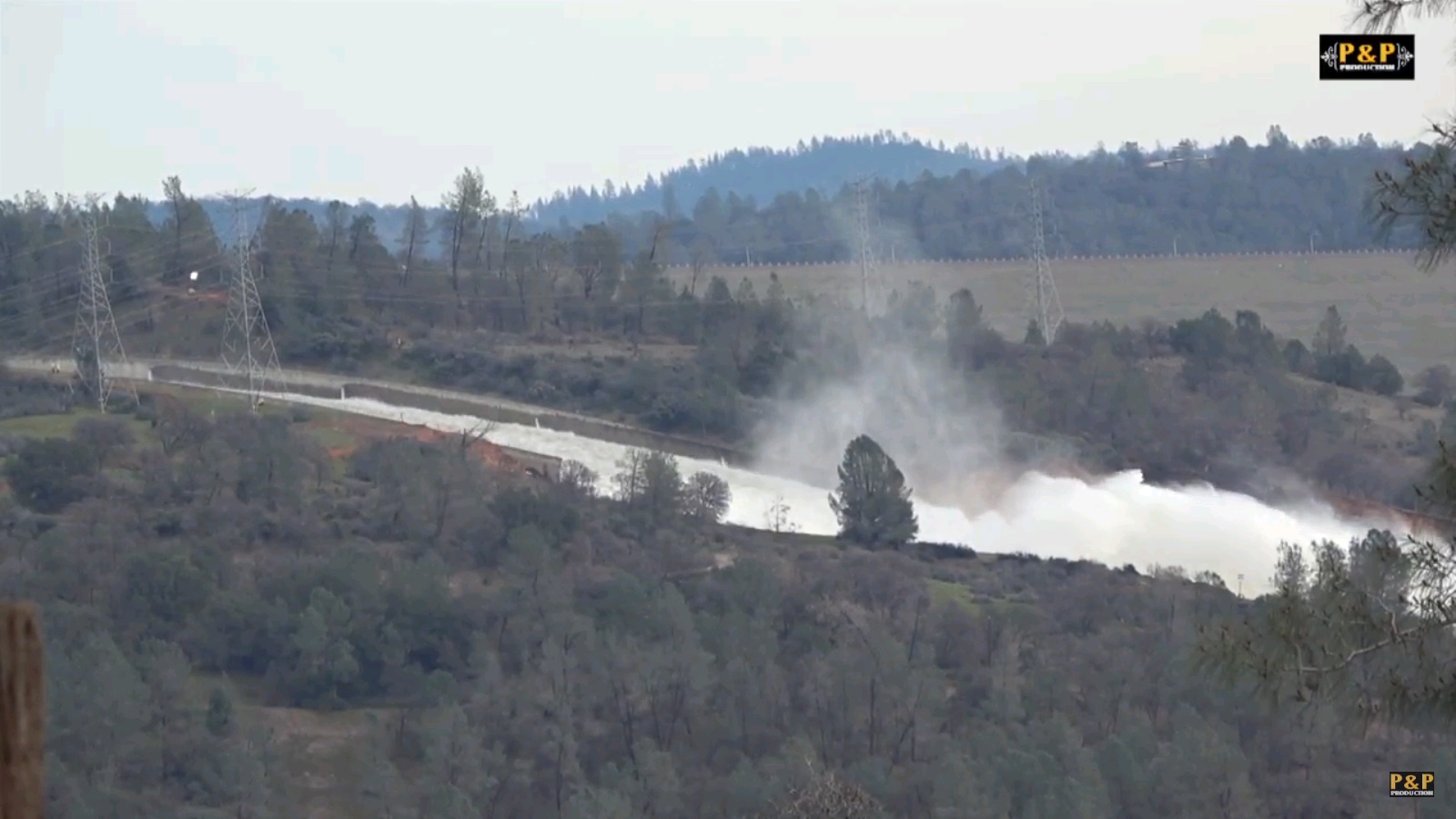
bigger link under picture. The red lines indicate the emergency spillway, not to be confused with the emergency spillway wall. The news kept saying there was a hole in the emergency spillway and it was growing.. They were either very confused or they were talking about ground erosion and were being dicks about it. that erosion is where those red lines are.. To the right of that you have your Main spillway. Long concrete Ramp. With flood control gates at the top. To the Right of that you have a DAM. at the bottom of that light green wedge of a Dam is the Dam's power station..
If I see one more person look at the main spillway and it's flood control gates and think that is the main dam....
not you guys, just youtube videos.. It's frustrating knowing so many people are getting fake news.
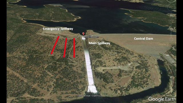
files.abovetopsecret.com...
IF you want to have something of some substance.. From yesterday.
here:
And just so you guys know the Dam is at "Flood control level"
This means that now they can safely let water out or store water so that the rivers downstream don't flood as much.
As in control the flood.
I hope he got his press pass.
edit on 20-2-2017 by Reverbs because: (no reason given)
a reply to: Reverbs
This has some good data.
Official press release.
I'll make some points
~they reached their target goal of 850 2am monday morning 2/20/2017. (they almost hit it at midnight sunday which was right on the money for what they wanted) now at 849
~the current expected inflows for the Dam are 108,000 cfs..
~they will leave the outlows at 60,000 cfs to continue to clear out the bottom of the main spillway.
~Lake levels are expected to rise about 5-6 feet. (to around 855 feet.. Remember how I said the emergency spilway was in no more danger?)
~after peak of the storm they expect inflows to drop back down with the colder weather to aroudn 20-25,000 cfs. (and the water will go back to draining.
~looking for opportunities to shut off main spillway to clear out debri to turn back on power station. (based on lake levels, what is safe, which if I am hearing correctly might be tried in about 3 days.. My prediction was power station on in 2 weeks, I said that maybe a couple days ago lets see if I'm close This gives them 16,000 cfs additional outflow without causing erosion to the main spillway, so turning this back on is what I've been watching this whole time)
~4 priority areas on the emergency spillway (the dirt hill) 3 are complete or 95%, and one is about half done. Those are key areas to stop erosion in the crazy event the emergency spillway has to be used down the line..
~I was right that they got the lines back connected to the power plant. the pooled water doesn't let the plant run so the debris needs to be moved so the water can flow down the river.(I didn't say that with full knowledge just monitoring drone footage closely that's what I thought I saw and I knew it was a goal of theirs.. It was nuts to watch. Helicopters straining diagonal pulling on these high tension power cables re stringing them.. )
~kept the power house dry.. (surprising.. #s like underwater..)
Questions start at 19:00
edit on 20-2-2017 by Reverbs because: (no reason given)

a reply to: jappee
Here is an assessment from dam experts about how this could have happened to the Oroville Dam spillway.
Seems like they hashed this dam project together
Shame it's going to cost them a lot of time and money to replace the spillway.
Here is an assessment from dam experts about how this could have happened to the Oroville Dam spillway.
Damage to Oroville's main spillway 'was an accident waiting to happen
“It was an accident waiting to happen from Dayff One,” said Don Colson, a retired engineer who worked on the Oroville Dam design in the 1960s and went on to a 36-year career at the state water agency. “This was a mistake that went back to the very beginning.”
Colson, who worked on other parts of the dam, said the design of the spillway never fully analyzed the potential for cavitation, which occurs when roiling water creates air pockets that cause high-pressure intrusion into cracks and fissures. The action can chew through thick concrete and even steel.
But some of the nation’s top civil engineers are already pointing to some likely suspects: design flaws, misunderstood geology and poor maintenance over the years.
Seems like they hashed this dam project together
The dam was one of many built in a flurry of construction in the 1960s, when engineering analysis was far less sophisticated than it is today and engineers had to rely on slide rules rather than computational models
Shame it's going to cost them a lot of time and money to replace the spillway.
All of the engineers said the state will likely have to replace the entire spillway, given the damage that occurred at such a moderate rate of discharge. That could cost more than $100 million, they estimated. And there are hundreds of thousands of cubic yards of debris that were deposited in the Feather River that will have to be dredged out to allow the dam to operate normally
a reply to: Reverbs
So here are the current numbers
Over the last 5 hours you see the lake level at
848.95
848.97
848.94
848.98
848.99
That means we are at the beginning of the rise in lake levels.
AS I said should get up to around 855 before dropping again.
EDIT:
he did get his press pass.. So this is from today.. The beginning pictures that go by fast are the barges that will be used to clear debris to try and open the power plant back up for the added 16,000 cfs outflow.
edit on 20-2-2017 by Reverbs because: (no reason given)
Here is a graphic I just downloaded. The water level at Oroville is rising again:
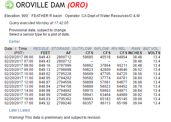
The latest outflow is 60,357 CFS. Inflow is 86,113 CFS. Not good.
Reverbs, what do you make of the above data, and this video?
Thanks!
The latest outflow is 60,357 CFS. Inflow is 86,113 CFS. Not good.
Reverbs, what do you make of the above data, and this video?
Thanks!
a reply to: dianajune
I'll watch the video in a second.
the inflow is expected to reach 110,000 cfs..
they will keep the outflow at 60,000 cfs
so that net 50,000 cfs will equal about 5 feet lake rise to around 855 feet until it begins to drop again.
once it's back down to 850 or lower they will shut off the main spillway to assess damage.
And also to try to dig out the water holding backing up to the dam power station so they can turn on that 16,000 cfs flow..
the flows after this storm are expected to go back to 25,000 cfs.. So it's not a big concern..
A lot of it is snow actually..
sorry I missed your post earlier.
EDIT
Solid video of things I don't have the time to look at..
I can't know everything and now everyone wants me back on the Dam, so I very much appreciate you being here to cover the other bases.
The Snow that's falling gives us a wonderful break right when we need it.. The only thing with that is it's just a time release.. It's going to melt at some point. So after we move through this storm I'm going to learn about snow packs and temperatures and tree lines and mountains.. all of that.
truly.
thank you.
edit on 20-2-2017 by Reverbs because: (no reason given)
It's going to be a long season...
Reservoirs feeding Lake Oroville are filled to brim as more rain rolls in
right now
It's a good read about the dams in the Oroville Dam watershed.
Reservoirs feeding Lake Oroville are filled to brim as more rain rolls in
right now
Moreno estimated the water released from Almanor, Bucks Lake and its other reservoirs at 2000 cubic feet per second. At about 2 percent of what DWR managers have been releasing from Lake Oroville, "it's the proverbial drop in a bucket," Moreno said.
It's a good read about the dams in the Oroville Dam watershed.
nice thank you.. Going to read.
Yea they've been keeping a lot of other dams around max capacity.. Shasta comes to mind, it was like 92% full, and expecting more rain, like huh? Some others were 100% full though.. It's kind of like a big human body and if one vein gets clogged the other veins work overtime but you can only divert so much flow.. Before the whole system has issues.
Anoter reason I want people to focus on the wider area.
It's ALL connected.
when you have less options in how you can act safely you have to watch everything..
that's all I'm not some government agent trying to make everyone put their head in the sand.
If I was I wouldn't be providing all this data and worrying youtube videos..
that was not directed at you desert except the first bit.
AND
So please everyone if you want to attack my posts attack the information not me.
You have the chance to correct me if I miss anything.
Please do so. PLEASE do so.
Just don't attack my personality as it has no bearing on this dangerous situation.
I hope that bolded part shows some clarity on what my mission is.
Yea they've been keeping a lot of other dams around max capacity.. Shasta comes to mind, it was like 92% full, and expecting more rain, like huh? Some others were 100% full though.. It's kind of like a big human body and if one vein gets clogged the other veins work overtime but you can only divert so much flow.. Before the whole system has issues.
Anoter reason I want people to focus on the wider area.
It's ALL connected.
when you have less options in how you can act safely you have to watch everything..
that's all I'm not some government agent trying to make everyone put their head in the sand.
If I was I wouldn't be providing all this data and worrying youtube videos..
that was not directed at you desert except the first bit.
In fact, all of the nine reservoirs in the Feather River watershed that feed directly into Lake Oroville are brimming with water from recent storms.
With more rain falling and another even heavier storm predicted for Monday and Tuesday, Plumas County officials are anxiously watching both the sky and the reservoirs above their communities.
"I'm watching, and I'm worried," said Plumas County Supervisor Kevin Goss.
AND
DWR officials were preoccupied with the situation at Oroville and unavailable for comment on how they manage Antelope Lake. "I don't even know where that reservoir is," said DWR spokesman Chris Orrock, preoccupied with the situation at Oroville, where nearly 200,000 people were briefly ordered to evacuate last week amid fears that the dam’s emergency spillway would fail.
So please everyone if you want to attack my posts attack the information not me.
You have the chance to correct me if I miss anything.
Please do so. PLEASE do so.
Just don't attack my personality as it has no bearing on this dangerous situation.
I hope that bolded part shows some clarity on what my mission is.
edit on 20-2-2017 by Reverbs because: (no reason given)
a reply to: Reverbs
I lost my time to edit. My above quotes come from Desert's link in his post above.
Let me make this post count more.
The lake has almost risen to 850 feet. the inflow is now almost 95,000 cfs
outflow still 60,000 cfs..
I will now make another prediction.
The water level will not reach 855 before the downturn and further draining of the lake.
I'd think more 854.
edit on 21-2-2017 by Reverbs because: (no reason given)
new topics
-
Something better
Dissecting Disinformation: 2 hours ago -
The Witcher IV — Cinematic Reveal Trailer | The Game Awards 2024
Video Games: 5 hours ago -
Friday thoughts
General Chit Chat: 6 hours ago -
More Ons?
Political Conspiracies: 6 hours ago -
Canada Post strike ended by the Government of Canada
Mainstream News: 6 hours ago -
They Know
Aliens and UFOs: 10 hours ago
top topics
-
They Know
Aliens and UFOs: 10 hours ago, 18 flags -
Canada Banning more Shovels
General Chit Chat: 15 hours ago, 10 flags -
Something better
Dissecting Disinformation: 2 hours ago, 7 flags -
More Ons?
Political Conspiracies: 6 hours ago, 5 flags -
Friday thoughts
General Chit Chat: 6 hours ago, 5 flags -
Canada Post strike ended by the Government of Canada
Mainstream News: 6 hours ago, 4 flags -
The Witcher IV — Cinematic Reveal Trailer | The Game Awards 2024
Video Games: 5 hours ago, 2 flags -
Drones (QUESTION) TERMINATOR (QUESTION)
General Chit Chat: 12 hours ago, 1 flags
active topics
-
And Here Come the Excuses!!
General Conspiracies • 200 • : DBCowboy -
A Bunch of Maybe Drones Just Flew Across Hillsborough County
Aircraft Projects • 47 • : 38181 -
Something better
Dissecting Disinformation • 7 • : WeMustCare -
Statements of Intent from Incoming Trump Administration Members - 2025 to 2029.
2024 Elections • 41 • : WeMustCare -
They Know
Aliens and UFOs • 57 • : WeMustCare -
I See a Different Attitude This Time Around with Congress
US Political Madness • 25 • : interupt42 -
A priest who sexually assaulted a sleeping man on a train has been jailed for 16 months.
Social Issues and Civil Unrest • 28 • : alwaysbeenhere2 -
Friday thoughts
General Chit Chat • 5 • : Flyingclaydisk -
Post A Funny (T&C Friendly) Pic Part IV: The LOL awakens!
General Chit Chat • 7906 • : underpass61 -
The goal of UFO's/ fallen angels doesn't need to be questioned - It can be discerned
Aliens and UFOs • 12 • : ARM19688