It looks like you're using an Ad Blocker.
Please white-list or disable AboveTopSecret.com in your ad-blocking tool.
Thank you.
Some features of ATS will be disabled while you continue to use an ad-blocker.

Quake Watch 2014
page: 28share:
muzzy
I'd say the stakes (odds) have been lowered.
Don't forget a M6 is a big release of energy.
No quakes mean a build up of tension, quakes mean release of tension.
Same with the 6.8 off California, less chance of the 9.0 ........
Normally, I would agree with you Muzzy, but that Mag 6.8 off California wasn't on the thrust fault.
It was in the Gorda Plate, which is being fractured, bent & compressed. The Gorda is trying to slide east due to it being pushed that direction from the spreading ridge to its west. But it is running into the locked Cascadia--which isn't budging at the moment. It's also being pushed north by the Pacific Plate trying to move past it toward Alaska. Smashed & crumpled--poor Gorda microplate, lol.
I'm fairly certain the most recent substantial earthquake to happen on the southern portion of the CSZ was this Mag 7.1 25 April 1992.
So it is still priming itself for a doozey at some point in the future.
reply to post by Olivine
Yeah, not sure I agree with muzzy there either, but for other reasons. Mostly, the issue of stress redistribution. When that quake let loose its energy, some of that will find its way north and south of epicenter and cause further stress loading on the surrounding area. I mean that is evident right away from the aftershocks. Look at their spread. And all it takes to trigger another one on a nearby fault is for that stress loading to push a loaded nearby point over the edge. Just hope it's not on the Cascadia Megathrust fault. So far though, all seems to be holding. For now.
And btw Puters, I object to your choice of names in the USGS comedy routine!
edit on Tue Mar 11th 2014 by TrueAmerican because: (no
reason given)
radpetey
Remember all the action just N. of Antarctica??
Well, I would say, "the stakes have just been raised."
earthquake.usgs.gov...
The wrong part of the page posted in my link.
I was referring to the south sandwich island quake.
My thought was that there have been quite a few quakes, in the last year, that were pretty close to that magnitude.
After the last couple down there, I started to think it was a sequence of foreshocks!
reply to post by radpetey
Yeah I was referring to those as well. The N Cal. reference was an afterthought.
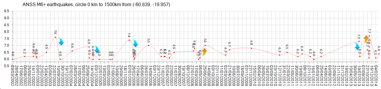
Here is what I'm looking at, 12 years of data off ANSS, delta=0 km to 1500 km from (-60.839,-19.957)
I see what you are suggesting, but its really a one off, and very recent, long term its not the normal pattern.
M7's are fairly rare.
Here I have split the results into years, then marked the M7's (and M6.9) in Bold and then Blue for an Aftershock sequence and Red for a Foreshock sequence. To be fair I gave a 3 month window to each.
A Foreshock sequence happened twice in 12 years.
WHEN, MAG, TYPE, LAT, LONG, DEPTH, LOCATION
9/03/2002 12:27, 6.0, Mw, -56.019, -27.332, 118.4, South Sandwich Islands Region
30/07/2002 6:55, 6.2, Mw, -57.889, -23.242, 33, South Sandwich Islands Region
12/11/2002 1:46, 6.2, Mw, -56.55, -27.536, 120, South Sandwich Islands Region
15/11/2002 19:58, 6.6, Mw, -56.051, -36.404, 10, South Georgia Island Region
17/12/2002 4:32, 6.2, Mw, -56.952, -24.825, 10, South Sandwich Islands Region
18/12/2002 14:12, 6.1, Mw, -57.092, -24.981, 10, South Sandwich Islands Region
17/04/2003 14:50, 6.5, Mw, -54.624, 1.432, 10, Bouvet Island Region
4/08/2003 4:37, 7.6, Mw, -60.532, -43.411, 10, Scotia Sea
30/09/2003 8:01, 6.0, Mw, -60.318, -33.401, 10, Scotia Sea
21/02/2004 2:34, 6.6, Mw, -58.425, -14.963, 10, East Of South Sandwich Islands
6/09/2004 12:42, 6.9, Mw, -55.372, -28.976, 10, South Sandwich Islands Region
11/09/2004 21:52, 6.1, Mw, -57.976, -25.342, 63.9, South Sandwich Islands Region
26/10/2004 20:48, 6.0, Mw, -57.067, -24.829, 10, South Sandwich Islands Region
26/10/2004 22:53, 6.4, Mw, -57.071, -24.679, 10, South Sandwich Islands Region
8/01/2005 18:45, 6.0, Mw, -55.299, -27.956, 10, South Sandwich Islands Region
18/05/2005 9:10, 6.0, Mw, -56.413, -26.863, 102.2, South Sandwich Islands Region
12/06/2005 19:26, 6.0, Mw, -56.293, -27.075, 94.1, South Sandwich Islands Region
2/01/2006 6:10, 7.4, Mw, -60.957, -21.606, 13, East Of South Sandwich Islands
3/03/2006 23:36, 6.0, Mw, -55.695, -4.232, 10, Southern Mid-Atlantic Ridge
10/03/2006 10:12, 6.1, Mw, -60.419, -46.505, 10, Scotia Sea
20/08/2006 3:41, 7.0, Mw, -61.029, -34.371, 13, Scotia Sea
20/01/2007 6:21, 6.2, Mw, -55.419, -29.533, 10, South Sandwich Islands Region
28/02/2007 23:13, 6.2, Mw, -55.245, -29.142, 10, South Sandwich Islands Region
8/03/2007 11:14, 6.2, Mw, -58.217, -7.615, 10, East Of South Sandwich Islands
28/04/2007 14:02, 6.1, Mw, -60.789, -20.208, 10, East Of South Sandwich Islands
24/06/2007 0:25, 6.5, Mw, -55.645, -2.626, 10, Southern Mid-Atlantic Ridge
10/02/2008 12:22, 6.6, Mw, -60.797, -25.586, 8, South Sandwich Islands Region
23/02/2008 15:57, 6.8, Mw, -57.335, -23.433, 14, South Sandwich Islands Region
14/04/2008 9:45, 6.0, Mw, -56.022, -28.035, 140.2, South Sandwich Islands Region
28/04/2008 15:57, 6.1, Mw, -58.739, -24.714, 35, South Sandwich Islands Region
30/06/2008 6:17, 7.0, Mw, -58.227, -22.099, 8, South Sandwich Islands Region
28/02/2009 14:33, 6.3, Mw, -60.525, -24.796, 15, South Sandwich Islands Region
16/04/2009 14:57, 6.7, Mw, -60.203, -26.858, 20, South Sandwich Islands Region
5/01/2010 4:55, 6.8, Mw, -58.173, -14.695, 13, East Of South Sandwich Islands
8/12/2010 5:24, 6.3, Mw, -56.412, -25.741, 29.4, South Sandwich Islands Region
6/03/2011 14:32, 6.5, Mw, -56.422, -27.063, 87.7, South Sandwich Islands Region
15/07/2011 13:26, 6.2, Mw, -60.762, -23.523, 10, South Sandwich Islands Region
3/09/2011 4:48, 6.4, Mw, -56.451, -26.847, 84, South Sandwich Islands Region
11/12/2011 9:54, 6.2, Mw, -56.009, -28.184, 116, South Sandwich Islands Region
22/01/2012 5:53, 6.0, Mw, -56.759, -25.147, 13, South Sandwich Islands Region
17/04/2012 19:03, 6.2, Mw, -59.016, -16.612, 12, East Of South Sandwich Islands
15/07/2013 14:03, 7.3, Mw, -60.8679, -25.1436, 30.98, South Sandwich Islands Region
26/07/2013 21:32, 6.2, Mw, -57.7893, -23.9594, 10.04, South Sandwich Islands Region
24/10/2013 19:25, 6.7, Mw, -58.2081, -12.9503, 26.09, East Of South Sandwich Islands
13/11/2013 23:45, 6.1, Mw, -60.2814, -47.1233, 11.07, Scotia Sea
16/11/2013 3:34, 6.9, Mw, -60.2627, -47.0621, 9.97, Scotia Sea
17/11/2013 9:04, 7.7, Mw, -60.2738, -46.4011, 10, Scotia Sea
1/02/2014 3:58, 6.1, Mw, -56.8269, -27.3253, 131.14, South Sandwich Islands Region
11/03/2014 2:44, 6.4, Mw, -60.8391, -19.9569, 10, East Of South Sandwich Islands
OK, I suppose that last one does raise the stakes a bit, only because of the short time since the last one in early Feb 2014.
Or it could just be a series of 6's like in 2002 and 2007.
That last 7.7 might be the biggest magnitude this area is capable of, and that might be it for another 1700+ years, I don't have any M8's in that area in my data going back to the year 314AD.
maybe this graph illustrates it better
 (click image for the
w__i__d__e__r version, opens in new tab/window)
(click image for the
w__i__d__e__r version, opens in new tab/window)
I'll have a look longer term, there were 5 other M7's back to 1963 when ANSS data starts.
( I have a Lumbar sprain, off work for a week at least, so have the time)
Yeah I was referring to those as well. The N Cal. reference was an afterthought.
Here is what I'm looking at, 12 years of data off ANSS, delta=0 km to 1500 km from (-60.839,-19.957)
I see what you are suggesting, but its really a one off, and very recent, long term its not the normal pattern.
M7's are fairly rare.
Here I have split the results into years, then marked the M7's (and M6.9) in Bold and then Blue for an Aftershock sequence and Red for a Foreshock sequence. To be fair I gave a 3 month window to each.
A Foreshock sequence happened twice in 12 years.
WHEN, MAG, TYPE, LAT, LONG, DEPTH, LOCATION
9/03/2002 12:27, 6.0, Mw, -56.019, -27.332, 118.4, South Sandwich Islands Region
30/07/2002 6:55, 6.2, Mw, -57.889, -23.242, 33, South Sandwich Islands Region
12/11/2002 1:46, 6.2, Mw, -56.55, -27.536, 120, South Sandwich Islands Region
15/11/2002 19:58, 6.6, Mw, -56.051, -36.404, 10, South Georgia Island Region
17/12/2002 4:32, 6.2, Mw, -56.952, -24.825, 10, South Sandwich Islands Region
18/12/2002 14:12, 6.1, Mw, -57.092, -24.981, 10, South Sandwich Islands Region
17/04/2003 14:50, 6.5, Mw, -54.624, 1.432, 10, Bouvet Island Region
4/08/2003 4:37, 7.6, Mw, -60.532, -43.411, 10, Scotia Sea
30/09/2003 8:01, 6.0, Mw, -60.318, -33.401, 10, Scotia Sea
21/02/2004 2:34, 6.6, Mw, -58.425, -14.963, 10, East Of South Sandwich Islands
6/09/2004 12:42, 6.9, Mw, -55.372, -28.976, 10, South Sandwich Islands Region
11/09/2004 21:52, 6.1, Mw, -57.976, -25.342, 63.9, South Sandwich Islands Region
26/10/2004 20:48, 6.0, Mw, -57.067, -24.829, 10, South Sandwich Islands Region
26/10/2004 22:53, 6.4, Mw, -57.071, -24.679, 10, South Sandwich Islands Region
8/01/2005 18:45, 6.0, Mw, -55.299, -27.956, 10, South Sandwich Islands Region
18/05/2005 9:10, 6.0, Mw, -56.413, -26.863, 102.2, South Sandwich Islands Region
12/06/2005 19:26, 6.0, Mw, -56.293, -27.075, 94.1, South Sandwich Islands Region
2/01/2006 6:10, 7.4, Mw, -60.957, -21.606, 13, East Of South Sandwich Islands
3/03/2006 23:36, 6.0, Mw, -55.695, -4.232, 10, Southern Mid-Atlantic Ridge
10/03/2006 10:12, 6.1, Mw, -60.419, -46.505, 10, Scotia Sea
20/08/2006 3:41, 7.0, Mw, -61.029, -34.371, 13, Scotia Sea
20/01/2007 6:21, 6.2, Mw, -55.419, -29.533, 10, South Sandwich Islands Region
28/02/2007 23:13, 6.2, Mw, -55.245, -29.142, 10, South Sandwich Islands Region
8/03/2007 11:14, 6.2, Mw, -58.217, -7.615, 10, East Of South Sandwich Islands
28/04/2007 14:02, 6.1, Mw, -60.789, -20.208, 10, East Of South Sandwich Islands
24/06/2007 0:25, 6.5, Mw, -55.645, -2.626, 10, Southern Mid-Atlantic Ridge
10/02/2008 12:22, 6.6, Mw, -60.797, -25.586, 8, South Sandwich Islands Region
23/02/2008 15:57, 6.8, Mw, -57.335, -23.433, 14, South Sandwich Islands Region
14/04/2008 9:45, 6.0, Mw, -56.022, -28.035, 140.2, South Sandwich Islands Region
28/04/2008 15:57, 6.1, Mw, -58.739, -24.714, 35, South Sandwich Islands Region
30/06/2008 6:17, 7.0, Mw, -58.227, -22.099, 8, South Sandwich Islands Region
28/02/2009 14:33, 6.3, Mw, -60.525, -24.796, 15, South Sandwich Islands Region
16/04/2009 14:57, 6.7, Mw, -60.203, -26.858, 20, South Sandwich Islands Region
5/01/2010 4:55, 6.8, Mw, -58.173, -14.695, 13, East Of South Sandwich Islands
8/12/2010 5:24, 6.3, Mw, -56.412, -25.741, 29.4, South Sandwich Islands Region
6/03/2011 14:32, 6.5, Mw, -56.422, -27.063, 87.7, South Sandwich Islands Region
15/07/2011 13:26, 6.2, Mw, -60.762, -23.523, 10, South Sandwich Islands Region
3/09/2011 4:48, 6.4, Mw, -56.451, -26.847, 84, South Sandwich Islands Region
11/12/2011 9:54, 6.2, Mw, -56.009, -28.184, 116, South Sandwich Islands Region
22/01/2012 5:53, 6.0, Mw, -56.759, -25.147, 13, South Sandwich Islands Region
17/04/2012 19:03, 6.2, Mw, -59.016, -16.612, 12, East Of South Sandwich Islands
15/07/2013 14:03, 7.3, Mw, -60.8679, -25.1436, 30.98, South Sandwich Islands Region
26/07/2013 21:32, 6.2, Mw, -57.7893, -23.9594, 10.04, South Sandwich Islands Region
24/10/2013 19:25, 6.7, Mw, -58.2081, -12.9503, 26.09, East Of South Sandwich Islands
13/11/2013 23:45, 6.1, Mw, -60.2814, -47.1233, 11.07, Scotia Sea
16/11/2013 3:34, 6.9, Mw, -60.2627, -47.0621, 9.97, Scotia Sea
17/11/2013 9:04, 7.7, Mw, -60.2738, -46.4011, 10, Scotia Sea
1/02/2014 3:58, 6.1, Mw, -56.8269, -27.3253, 131.14, South Sandwich Islands Region
11/03/2014 2:44, 6.4, Mw, -60.8391, -19.9569, 10, East Of South Sandwich Islands
OK, I suppose that last one does raise the stakes a bit, only because of the short time since the last one in early Feb 2014.
Or it could just be a series of 6's like in 2002 and 2007.
That last 7.7 might be the biggest magnitude this area is capable of, and that might be it for another 1700+ years, I don't have any M8's in that area in my data going back to the year 314AD.
maybe this graph illustrates it better

I'll have a look longer term, there were 5 other M7's back to 1963 when ANSS data starts.
( I have a Lumbar sprain, off work for a week at least, so have the time)
edit on 03000000696914 by muzzy because: add graph and clarify the colouring
@ Olivine and TrueAmerican
I see your points, but I don't necessarily buy into the impending Cascadia M9.0+ scenerio, and here is why.
If you look at history, say the last 1700 years .... 1700years M8+ quakes and the list
In the 1700-710 years ago period most of the action was in Europe, Greece, Switzerland, Portugal, Syria etc.
So do we say, OK recurrence levels say they are overdue for a M8-9???. No I don't believe so, over time the Tectonic Plates do settle and stop moving in sudden huge movements. Smaller (M7) events may lessen the chance of a M9.
This may be the case for Cascadia too, no one has proof that the 1700 years cycle will continue, even if there is one, that cycle theory itself is only based on silt deposits from pre history, which possibly may have been caused by other means (asteroid hit).
It needs more research, but I can't say I have seen a M9 with precursors apart from the Japan 2011 one, and that surprised everyone.
Those recurrence periods the geologists give faults are only guesswork, as we have seen from New Zealand's recent history, none of our recent M6+ events fitted the models.
Perhaps you could say the Europe/Med situation is only because records were kept there then, but not so in other places, but Japanese, Chinese and South American records go back that far too. The only record gap is in the SPac, who knows what was going on in 314 in Vanuatu or New Zealand??
Not saying for N Americas West Coasters to not prepare for a big quake, even a M8 would cause some destruction.
muzzy
reply to post by radpetey
I'll have a look longer term, there were 5 other M7's back to 1963 when ANSS data starts.
In the 39 year period 25/05/1963 to 9/03/2002 (when the other graph starts)
as I said we have 5 M7+'s,
of those only one of each type
27-28/12/1991 aftershock (7.2, 6.7)
10/07-26/08/1977 foreshock series (6.6, 6.1, 7.1)
only other things that stand out are;
swarm from 9/03/1993 - 2/05/1993 with 5 M6's (6.1-6.4)
swarm from 25/02/1973 - 25/04/1973 with 3 M6's (6.0-6.7)
quite a few doubles (within 3 months of each other)

so from 1963-2014 thats 3 foreshock series and 5 aftershock series relating to M7+'s
only 50 years of history, which isn't much in the big scheme of things.
you could say there might be a 37.5% chance those last 2 quakes in 2014 could develop into something bigger.
just numbers .............. the forces that drive such things could decide to do something else completely different.
* I re-calibrated that first graph as well, so they match and are clearer. But I can't change the screen image as the 4 hours for editing are up, even though it was only 3:45hrs ago. Clicking it will bring up the altered version in another tab.
* that is, assuming the 3 month period defining foreshock and aftershock, who knows what it actually is, some say the period could be years long. If that is the case then all those prior to the 7.7 in Nov 2013 would be foreshocks!. And that is dicounting "triggering" from one Fault to another, would need to break it down into smaller areas .......... endless scenarios
edit on 03000000696914 by muzzy because: add some more blah
blah
edit on 03u696914 by muzzy because: as usual, every answer results in another question
F-E Region: Bismarck Sea
Time: 2014-03-11 22:03:12.3 UTC
Magnitude: 6.1 (Mw)
Epicenter: 148.44°E 3.19°S
Depth: 10 km
Status: M - manually revised
geofon.gfz-potsdam.de...
Good work Muzzy!! Leave it to you to punch gut feelers right in gut with good, cold hard ,scientific statistics!
That's what we need on these sites!
Thank you, for the info!
However, I still have a feeling about a mid to upper 7....we shall see
That's what we need on these sites!
Thank you, for the info!
However, I still have a feeling about a mid to upper 7....we shall see
Wednesday March 12 2014, 00:31:46 UTC off the coast of Oregon 5.1 12.0 USGS Feed
earthquake.usgs.gov...
2 quakes a 4.8 and a 5.1
M5.1 - Off the coast of Oregon
2014-03-12 00:31:46 UTC
Event Time
2014-03-12 00:31:46 UTC
2014-03-11 15:31:46 UTC-09:00 at epicenter
2014-03-11 17:31:46 UTC-07:00 system time
Location
44.306°N 129.093°W depth=12.0km (7.5mi)
Nearby Cities
398km (247mi) WNW of Barview, Oregon
405km (252mi) WNW of Coos Bay, Oregon
463km (288mi) W of Dallas, Oregon
465km (289mi) W of Corvallis, Oregon
485km (301mi) W of Salem, Oregon
edit on 7/30/2012 by dreamfox1 because: (no reason given)
edit on 7/30/2012 by dreamfox1
because: (no reason given)
Now THAT recent eq off the oregon coast is the area we need to monitor... its possible that 6.8 did add to the stress of the cascadia area... lets
watch this very closely.. could get interesting indeed
edit on 01/04/2009 by steve95988 because: (no reason given)
One quick comment on the Northern California earthquake. I believe that the earlier 5.8M in Southern Mexico are part of the same cause. That is not to
say that the Mexican quake triggered Northern California. Maybe it did. Maybe it didn't. But that is not to say that they aren't a coincidence.
Also, technically, we haven't had a 7+ in a while. The last two largest were just under 7.
What I really wanted to comment on is Kansas.
For the record, there is no lake to be found anywhere near the epicenter. Yes, there is drilling within spitting distance. No, really is a long golf shot. I could probably hit the derrick with a good drive. Actually, can drive a ball 300 yards on a good day. So, I would have to pull up a bit since it's only about 266 yards to the drilling site.
I wonder if any golf courses have wells on them. What am I saying? Of course there are.
I've been a bit behind on reading here and just notice Puterman's thread on the 5.7M injection earthquake in Oklahoma.
All I can say is I trust the data. In the end, if the numbers are corrupted, they tell the story.
What don't trust is the geologists turned politicians. Austin Holland is no better than a spin doctor.He's like a doctor paid by the cigarette companies telling us there is doubt about the cancer link.
I'm prepared to be wrong. But I knew the 5.7M was an injection quake. Because there was an injection near the epicenter. And, the fact the same thing had just happened in Arkansas. And, the scientific evidence that injection causes earthquakes.
To ignore these facts is...
ignoring facts
it's
spinning facts
which is lying
Mr Holland is a liar.
Sieches in Norway from 2011.
www.dailymail.co.uk...
Had to add. I must be more brain dead than I thought. I forgot about this earthquake. I even meant to check out epicenter but duh. So, speaking of duh, here's another no brainer.
www.wksu.org...
america.aljazeera.com...
Apparently, there's been five earthquakes in Ohio. Sorry, to repeat if someone else mention them. So, it's like duh, we have more earthquake and duh, they seem to be near injection wells in another state. And, it's right near Youngstown where another injection well was halted because it was causing earthquakes. So, duh.
And here's a place to compare. Ohio compared to Oklahoma. In Ohio, when there seems to be a link with injection wells and earthquakes, the officials do the responsible thing, they stop. In Oklahoma, the officials shrug their shoulders and point attention elsewhere. The funny thing, or the not so funny thing, is that in Oklahoma, there are hundred times the amount of earthquakes. And wells. Yet, they keep on keeping on.
In Ohio, public safety is directing policy and decisions. And, I wouldn't claim they are totally concerned. They're still allowing injection. But, when there's an issue, they respond.
In Oklahoma, it's criminal negligence. If you are serving someone alcohol, it is against the law to then look the other way when your drunks jump in their cars and endanger lives.
Also, technically, we haven't had a 7+ in a while. The last two largest were just under 7.
What I really wanted to comment on is Kansas.
For the record, there is no lake to be found anywhere near the epicenter. Yes, there is drilling within spitting distance. No, really is a long golf shot. I could probably hit the derrick with a good drive. Actually, can drive a ball 300 yards on a good day. So, I would have to pull up a bit since it's only about 266 yards to the drilling site.
I wonder if any golf courses have wells on them. What am I saying? Of course there are.
I've been a bit behind on reading here and just notice Puterman's thread on the 5.7M injection earthquake in Oklahoma.
All I can say is I trust the data. In the end, if the numbers are corrupted, they tell the story.
What don't trust is the geologists turned politicians. Austin Holland is no better than a spin doctor.He's like a doctor paid by the cigarette companies telling us there is doubt about the cancer link.
I'm prepared to be wrong. But I knew the 5.7M was an injection quake. Because there was an injection near the epicenter. And, the fact the same thing had just happened in Arkansas. And, the scientific evidence that injection causes earthquakes.
To ignore these facts is...
ignoring facts
it's
spinning facts
which is lying
Mr Holland is a liar.
edit on 12-3-2014 by ericblair4891 because: (no reason given)
Sieches in Norway from 2011.
www.dailymail.co.uk...
edit on 12-3-2014 by
ericblair4891 because: (no reason given)
Had to add. I must be more brain dead than I thought. I forgot about this earthquake. I even meant to check out epicenter but duh. So, speaking of duh, here's another no brainer.
www.wksu.org...
america.aljazeera.com...
Apparently, there's been five earthquakes in Ohio. Sorry, to repeat if someone else mention them. So, it's like duh, we have more earthquake and duh, they seem to be near injection wells in another state. And, it's right near Youngstown where another injection well was halted because it was causing earthquakes. So, duh.
And here's a place to compare. Ohio compared to Oklahoma. In Ohio, when there seems to be a link with injection wells and earthquakes, the officials do the responsible thing, they stop. In Oklahoma, the officials shrug their shoulders and point attention elsewhere. The funny thing, or the not so funny thing, is that in Oklahoma, there are hundred times the amount of earthquakes. And wells. Yet, they keep on keeping on.
In Ohio, public safety is directing policy and decisions. And, I wouldn't claim they are totally concerned. They're still allowing injection. But, when there's an issue, they respond.
In Oklahoma, it's criminal negligence. If you are serving someone alcohol, it is against the law to then look the other way when your drunks jump in their cars and endanger lives.
edit on 12-3-2014 by ericblair4891 because: (no reason given)
KANSAS!!!
2.7
12km ENE of Anthony, Kansas
2014-03-12 20:16:54 UTC-04:005.0 km
3.2
15km ENE of Anthony, Kansas
2014-03-12 15:35:26 UTC-04:005.0 km
2.9
15km ENE of Anthony, Kansas
2014-03-12 14:00:04 UTC-04:005.0 km
2.6
13km ENE of Anthony, Kansas
2014-03-12 08:57:54 UTC-04:006.2 km
3.3
13km ENE of Anthony, Kansas
2014-03-12 05:50:25 UTC-04:003.1 km
Yea,(i'm on a laptop-=I am totaI frustrated. I hate laptops. It makes my job ten times more difficult. \\
ab
I'M SERIOUS. everytime i comeo ut here late and try to typek i befcome infur9ai9u88iookkiated. frig where's the i. i become infuriated. why?
because the keyboard is not whatg i learned in freakn' tenth grade or grade ten typing class. i am agood typist, Except, dfor when i get onthis freakin narrow keyborard. i find i can't hi t the right key. ndyay . kansas is abormal . screajm, u gate tgus effub jetbiard,l
agggggjjhjjjjjjjjjjjjjjjjjjjjjjjjjjjjjjjjjjkkkkkkkkkkkkkhhhhhhhhhhhhhhhhhhhh
athg
t
relax
put your fingers at the right keys
he Miss Duncan, taught me to put my fingers at j and f. She was my grade ten typing teacher. Practice, practice, practice. Then, it becomes rote. But, since this freakin' laptop has narrow keys, I feel like a retard. I'm not using that term in a derogatory way. Becaus$$$ I have Autism. My son has been offically diagnosed.
The problem is the different. WHen i use something I'm not normally accoustoumed to, I flip out. It's routine. Id sometime is different, I lose control...
Kansas.
I've been ws
I'm going onto another typewriter so i don't lose my mind. see yuo9 in a bit.
fdriweckin '' narrow tuypewriters''14
I am on a different keyboard. So, I hope I cam be articulate. Kansas. Five earthquakes. Let's check the statistics.
In 1906, In January, there was a large earthquake in Kansas. Less than four months later, San Fransico erupted?
Coincidence?
Just keep watching the mid west usa
2.7
12km ENE of Anthony, Kansas
2014-03-12 20:16:54 UTC-04:005.0 km
3.2
15km ENE of Anthony, Kansas
2014-03-12 15:35:26 UTC-04:005.0 km
2.9
15km ENE of Anthony, Kansas
2014-03-12 14:00:04 UTC-04:005.0 km
2.6
13km ENE of Anthony, Kansas
2014-03-12 08:57:54 UTC-04:006.2 km
3.3
13km ENE of Anthony, Kansas
2014-03-12 05:50:25 UTC-04:003.1 km
edit on 12-3-2014 by ericblair4891 beca I iiiiiiuse: (no reason given)
edit on 12-3-2014 by
ericblair4891 because: (no reason given)
Yea,(i'm on a laptop-=I am totaI frustrated. I hate laptops. It makes my job ten times more difficult. \\
ab
I'M SERIOUS. everytime i comeo ut here late and try to typek i befcome infur9ai9u88iookkiated. frig where's the i. i become infuriated. why?
because the keyboard is not whatg i learned in freakn' tenth grade or grade ten typing class. i am agood typist, Except, dfor when i get onthis freakin narrow keyborard. i find i can't hi t the right key. ndyay . kansas is abormal . screajm, u gate tgus effub jetbiard,l
agggggjjhjjjjjjjjjjjjjjjjjjjjjjjjjjjjjjjjjjkkkkkkkkkkkkkhhhhhhhhhhhhhhhhhhhh
athg
t
relax
put your fingers at the right keys
he Miss Duncan, taught me to put my fingers at j and f. She was my grade ten typing teacher. Practice, practice, practice. Then, it becomes rote. But, since this freakin' laptop has narrow keys, I feel like a retard. I'm not using that term in a derogatory way. Becaus$$$ I have Autism. My son has been offically diagnosed.
The problem is the different. WHen i use something I'm not normally accoustoumed to, I flip out. It's routine. Id sometime is different, I lose control...
Kansas.
I've been ws
I'm going onto another typewriter so i don't lose my mind. see yuo9 in a bit.
fdriweckin '' narrow tuypewriters''14
edit on 12-3-2014 by ericblair4891 because: (no reason given)
I am on a different keyboard. So, I hope I cam be articulate. Kansas. Five earthquakes. Let's check the statistics.
edit on 12-3-2014 by ericblair4891 because: (no reason given)
In 1906, In January, there was a large earthquake in Kansas. Less than four months later, San Fransico erupted?
Coincidence?
Just keep watching the mid west usa
edit on 12-3-2014 by ericblair4891 because: (no reason given)
edit on
12-3-2014 by ericblair4891 because: (no reason given)
Magnitude M 6.4
Region WESTERN HONSHU, JAPAN
Date time 2014-03-13 17:06:34.3 UTC
Location 34.72 N ; 132.47 E
Depth 10 km
Distances 587 km SE of Seoul, South Korea / pop: 10,349,312 / local time: 02:06:34.3 2014-03-14
666 km W of Tokyo, Japan / pop: 8,336,599 / local time: 02:06:34.3 2014-03-14
766 km SE of Pyongyang, North Korea / pop: 3,222,000 / local time: 02:06:34.3 2014-03-14
www.emsc-csem.org...
I note we are in that wonderful period of the year where I can post in the future/ My post is timed 18:17 but it is only 17:21 here. Why is it that ATS is incapable of working with time zones. NOT all the world changes time when the US does!
edit on 13/3/2014 by PuterMan because: (no reason
given)
Magnitude 6.3 - Kyushu. Japan (235) [F]
Location in Google Maps
- Date-Time: Thursday, March 13, 2014 @ 17:06:51 UTC
- Earthquake location: 33.683°N, 131.737°E,
- Earthquake depth: 82.9 km
- Distances:
13km (8mi) N of Kunisaki-shi, Japan
30km (18mi) ENE of Bungo-Takada-shi, Japan
31km (19mi) NNE of Kitsuki, Japan
36km (22mi) SSW of Hikari, Japan
609km (378mi) SE of Seoul, South Korea
- Event ID: usc000nabv
Derived from Event Data Source: USGS
Powered by QVSData
edit on
13/3/2014 by PuterMan because: (no reason given)
Focal parameters of the event is a thing of the automatic processing by the Hi-net.
Hypocenter distribution map in the background, is a plot the hypocenter by the Japan Meteorological Agency. (translation)
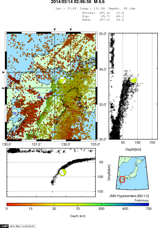
Nothing in the previous week in this area (Inland Sea, Japan) to indicate anything amiss. (gsaim NIED maps here)
Thats what I keep saying (and referring to off N California as well), it is more often locations that are NOT showing activity that have the big events.
This one should have a few aftershocks to keep me busy for a while, although the depth might effect the number of them.
Hypocenter distribution map in the background, is a plot the hypocenter by the Japan Meteorological Agency. (translation)
Nothing in the previous week in this area (Inland Sea, Japan) to indicate anything amiss. (gsaim NIED maps here)
Thats what I keep saying (and referring to off N California as well), it is more often locations that are NOT showing activity that have the big events.
This one should have a few aftershocks to keep me busy for a while, although the depth might effect the number of them.
edit on 03u717114 by
muzzy because: (no reason given)
based on "Western Japan" data from NIED.
24hrs B4 Oita,Kyushsu 6.6 interactive map
1st hour of aftershocks interactive map, 4 of those are in an arc 129-216km away from the 6.6 to the SW, not sure what that is about, here is the list of the Inland Sea/Oita Prefecture aftershocks after 1 hour;
Date/Time UTC, Lat, Lon, Mag, M/Type, Depth, TTNT
13/03/2014 17:06:50, 33.6892, 131.8883, 6.6, ML, 85.1, 119,786.623716
13/03/2014 17:09:48, 33.6031, 131.8992, 4.1, ML, 77.9, 21.301409
13/03/2014 17:10:50, 33.7034, 131.8887, 3.5, ML, 75.9, 2.681688
13/03/2014 17:12:05, 33.7363, 132.0615, 3.1, ML, 88.9, 0.673610
13/03/2014 17:13:48, 33.5969, 131.902, 3.0, ML, 79.7, 0.476879
13/03/2014 17:19:48, 33.6969, 132.0175, 1.7, ML, 61.5, 0.005351
13/03/2014 17:20:55, 33.6826, 131.8819, 2.0, ML, 76.3, 0.015080
13/03/2014 17:22:07, 33.6686, 131.8778, 2.4, ML, 75.2, 0.060036
13/03/2014 17:26:38, 33.67, 131.9432, 1.8, ML, 66.3, 0.007558
13/03/2014 17:34:22, 32.5556, 130.0177, 0.9, ML, 9.1, 0.000338
13/03/2014 17:35:57, 32.5114, 132.0403, 1.1, ML, 33.4, 0.000674
13/03/2014 17:43:01, 33.6774, 131.9479, 2.5, ML, 66.2, 0.084802
13/03/2014 18:01:31, 31.8163, 131.0691, 1.2, ML, 6.3, 0.000951
13/03/2014 18:02:45, 32.8736, 129.7597, 1.5, ML, 8.7, 0.002682
13/03/2014 18:03:08, 33.6018, 131.9035, 2.3, ML, 78.4, 0.042502
13/03/2014 18:11:04, 32.3989, 130.5822, 0.6, ML, 8.2, 0.000120
no doubt that will all change, update due in 3 hours from NIED
If you zoom out on that 2nd map and change to Terrain view you can clearly see the Median Tectonic Line (MTL). Running east-west in Shikoku and the Kii Peninsula is the Japanese longest (over 1000 km long) fault zone consisting mainly right-lateral strike-slip faults. The MTL can be readily traced as lineaments on the ground.
The southwest Japan is conventionally divided into the outer zone (Pacific side) and the inner zone (continental side) by the MTL, although the line is not shown on USGS's Plate Boundary KML file.
This MTL was also close to the location of the 12/04/2013 Awaji Island M6.3. Both these M6's on the continental side of the MTL.
For your convenience I have created a new JapanMTL file/map showing both events mentioned. I'll have a look back and see if there are more big ones on that zone, and if there is, will add them to the file in due course.
24hrs B4 Oita,Kyushsu 6.6 interactive map
1st hour of aftershocks interactive map, 4 of those are in an arc 129-216km away from the 6.6 to the SW, not sure what that is about, here is the list of the Inland Sea/Oita Prefecture aftershocks after 1 hour;
Date/Time UTC, Lat, Lon, Mag, M/Type, Depth, TTNT
13/03/2014 17:06:50, 33.6892, 131.8883, 6.6, ML, 85.1, 119,786.623716
13/03/2014 17:09:48, 33.6031, 131.8992, 4.1, ML, 77.9, 21.301409
13/03/2014 17:10:50, 33.7034, 131.8887, 3.5, ML, 75.9, 2.681688
13/03/2014 17:12:05, 33.7363, 132.0615, 3.1, ML, 88.9, 0.673610
13/03/2014 17:13:48, 33.5969, 131.902, 3.0, ML, 79.7, 0.476879
13/03/2014 17:19:48, 33.6969, 132.0175, 1.7, ML, 61.5, 0.005351
13/03/2014 17:20:55, 33.6826, 131.8819, 2.0, ML, 76.3, 0.015080
13/03/2014 17:22:07, 33.6686, 131.8778, 2.4, ML, 75.2, 0.060036
13/03/2014 17:26:38, 33.67, 131.9432, 1.8, ML, 66.3, 0.007558
13/03/2014 17:34:22, 32.5556, 130.0177, 0.9, ML, 9.1, 0.000338
13/03/2014 17:35:57, 32.5114, 132.0403, 1.1, ML, 33.4, 0.000674
13/03/2014 17:43:01, 33.6774, 131.9479, 2.5, ML, 66.2, 0.084802
13/03/2014 18:01:31, 31.8163, 131.0691, 1.2, ML, 6.3, 0.000951
13/03/2014 18:02:45, 32.8736, 129.7597, 1.5, ML, 8.7, 0.002682
13/03/2014 18:03:08, 33.6018, 131.9035, 2.3, ML, 78.4, 0.042502
13/03/2014 18:11:04, 32.3989, 130.5822, 0.6, ML, 8.2, 0.000120
no doubt that will all change, update due in 3 hours from NIED
edit on 03000000717114 by muzzy because: forgot the header for the
list
If you zoom out on that 2nd map and change to Terrain view you can clearly see the Median Tectonic Line (MTL). Running east-west in Shikoku and the Kii Peninsula is the Japanese longest (over 1000 km long) fault zone consisting mainly right-lateral strike-slip faults. The MTL can be readily traced as lineaments on the ground.
The southwest Japan is conventionally divided into the outer zone (Pacific side) and the inner zone (continental side) by the MTL, although the line is not shown on USGS's Plate Boundary KML file.
This MTL was also close to the location of the 12/04/2013 Awaji Island M6.3. Both these M6's on the continental side of the MTL.
For your convenience I have created a new JapanMTL file/map showing both events mentioned. I'll have a look back and see if there are more big ones on that zone, and if there is, will add them to the file in due course.
edit on 03u717114 by muzzy because:
(no reason given)
M 5.6 - 187km WSW of Gold Beach, Oregon
Tsunami Warning Center = No tsumani expected
Time
2014-03-13 14:11:37 UTC-05:00
Location
41.940°N 126.605°W
Depth
15.0km
Tsunami Warning Center = No tsumani expected
Time
2014-03-13 14:11:37 UTC-05:00
Location
41.940°N 126.605°W
Depth
15.0km
reply to post by berkeleygal
earthquake.usgs.gov...
Revised by usgs to
M5.2
- 209km WSW of Gold Beach, Oregon
2014-03-13 19:11:35 UTC
Event Time
2014-03-13 19:11:35 UTC
2014-03-13 11:11:35 UTC-08:00 at epicenter
2014-03-13 12:11:35 UTC-07:00 system time
Location
41.890°N 126.857°W depth=10.0km (6.2mi)
Nearby Cities
209km (130mi) WSW of Gold Beach, Oregon
253km (157mi) WNW of McKinleyville, California
255km (158mi) WNW of Eureka, California
258km (160mi) WNW of Arcata, California
459km (285mi) SW of Salem, Oregon
Beginning to think something big this way comes :O
edit on 7/30/2012 by dreamfox1 because: (no reason given)
reply to post by dreamfox1
Lucky for me i live inland by 100 miles or so.. but we felt the 6.8, im sure when we get a 8 or 9mw here, its gonna be hell on the coast if a tsunami is produced... n cali coastline and s oregon coastlines have some beautiful sights and really nice people..
But the way these "other quakes" are popping up in different spots around the gorda plate makes me think something is up too.
reply to post by dreamfox1
The little Mag 3.3 that followed 28 seconds after the 5.2, near the water's edge at Crescent City, CA, is interesting.
It was most likely triggered by the larger offshore quake. And if you look at the depth given, the depth uncertainty, and the fact that it hasn't been reviewed, it may have been on the thrust fault interface.
edit on 3/13/2014 by Olivine because: bad maths
edit on 3/13/2014 by Olivine because: (no reason given)
new topics
-
BIDEN Admin Begins Planning For January 2025 Transition to a New President - Today is 4.26.2024.
2024 Elections: 1 hours ago -
Big Storms
Fragile Earth: 3 hours ago -
Where should Trump hold his next rally
2024 Elections: 5 hours ago -
Shocking Number of Voters are Open to Committing Election Fraud
US Political Madness: 6 hours ago -
Gov Kristi Noem Shot and Killed "Less Than Worthless Dog" and a 'Smelly Goat
2024 Elections: 7 hours ago -
Falkville Robot-Man
Aliens and UFOs: 7 hours ago -
James O’Keefe: I have evidence that exposes the CIA, and it’s on camera.
Whistle Blowers and Leaked Documents: 8 hours ago -
Australian PM says the quiet part out loud - "free speech is a threat to democratic dicourse"...?!
New World Order: 9 hours ago -
Ireland VS Globalists
Social Issues and Civil Unrest: 9 hours ago -
Biden "Happy To Debate Trump"
2024 Elections: 10 hours ago
top topics
-
Australian PM says the quiet part out loud - "free speech is a threat to democratic dicourse"...?!
New World Order: 9 hours ago, 14 flags -
James O’Keefe: I have evidence that exposes the CIA, and it’s on camera.
Whistle Blowers and Leaked Documents: 8 hours ago, 14 flags -
Blast from the past: ATS Review Podcast, 2006: With All Three Amigos
Member PODcasts: 12 hours ago, 13 flags -
Biden "Happy To Debate Trump"
2024 Elections: 10 hours ago, 12 flags -
Mike Pinder The Moody Blues R.I.P.
Music: 12 hours ago, 8 flags -
What is the white pill?
Philosophy and Metaphysics: 11 hours ago, 6 flags -
Shocking Number of Voters are Open to Committing Election Fraud
US Political Madness: 6 hours ago, 6 flags -
RAAF airbase in Roswell, New Mexico is on fire
Aliens and UFOs: 10 hours ago, 5 flags -
Ireland VS Globalists
Social Issues and Civil Unrest: 9 hours ago, 5 flags -
Where should Trump hold his next rally
2024 Elections: 5 hours ago, 5 flags
active topics
-
Gov Kristi Noem Shot and Killed "Less Than Worthless Dog" and a 'Smelly Goat
2024 Elections • 53 • : cherokeetroy -
BIDEN Admin Begins Planning For January 2025 Transition to a New President - Today is 4.26.2024.
2024 Elections • 9 • : AwakeNotWoke -
RAAF airbase in Roswell, New Mexico is on fire
Aliens and UFOs • 10 • : Ophiuchus1 -
Big Storms
Fragile Earth • 13 • : AwakeNotWoke -
SHORT STORY WRITERS CONTEST -- April 2024 -- TIME -- TIME2024
Short Stories • 26 • : Encia22 -
Biden "Happy To Debate Trump"
2024 Elections • 50 • : Lumenari -
Falkville Robot-Man
Aliens and UFOs • 9 • : CosmicFocus -
ALERT - U.S. President JOE BIDEN Examined and Found NOT OF SOUND MIND.
2024 Elections • 65 • : SchrodingersRat -
James O’Keefe: I have evidence that exposes the CIA, and it’s on camera.
Whistle Blowers and Leaked Documents • 13 • : theatreboy -
Where should Trump hold his next rally
2024 Elections • 21 • : Dandandat3