It looks like you're using an Ad Blocker.
Please white-list or disable AboveTopSecret.com in your ad-blocking tool.
Thank you.
Some features of ATS will be disabled while you continue to use an ad-blocker.

Quake Watch 2014
page: 25share:
reply to post by radpetey
I think this series of earthquakes is actually on the Ash Hill fault in the Panamint Valley, which is still thought capable of generating a large magnitude quake.
The Garlock is about 40 miles south of this swarm's epicenter. Thank goodness. The Garlock is a big, scary fault.
I think this series of earthquakes is actually on the Ash Hill fault in the Panamint Valley, which is still thought capable of generating a large magnitude quake.
The Garlock is about 40 miles south of this swarm's epicenter. Thank goodness. The Garlock is a big, scary fault.
Odd Quake
earthquake.usgs.gov...
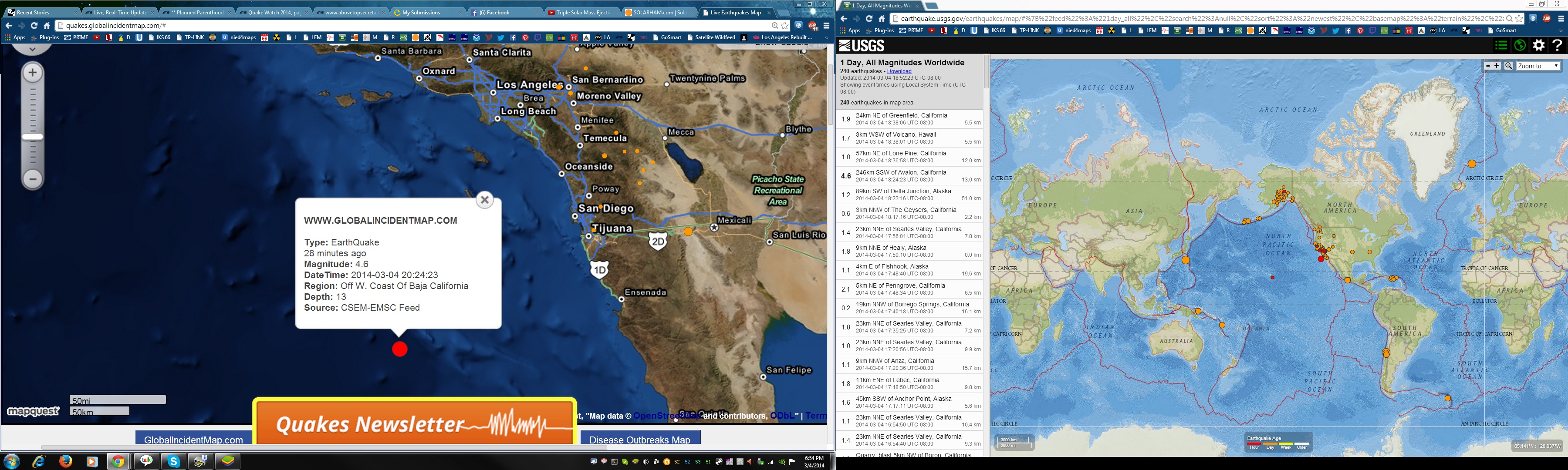
M4.6 - 246km SSW of Avalon, California
2014-03-05 02:24:23 UTC
Event Time
2014-03-05 02:24:23 UTC
2014-03-04 18:24:23 UTC-08:00 at epicenter
2014-03-04 18:24:23 UTC-08:00 system time
Location
31.329°N 119.434°W depth=13.0km (8.1mi)
Nearby Cities
246km (153mi) SSW of Avalon, California
253km (157mi) WSW of Rosarito, Mexico
259km (161mi) WSW of Imperial Beach, California
260km (162mi) SW of Coronado, California
731km (454mi) WSW of Phoenix, Arizona
files.abovetopsecret.com...
earthquake.usgs.gov...
M4.6 - 246km SSW of Avalon, California
2014-03-05 02:24:23 UTC
Event Time
2014-03-05 02:24:23 UTC
2014-03-04 18:24:23 UTC-08:00 at epicenter
2014-03-04 18:24:23 UTC-08:00 system time
Location
31.329°N 119.434°W depth=13.0km (8.1mi)
Nearby Cities
246km (153mi) SSW of Avalon, California
253km (157mi) WSW of Rosarito, Mexico
259km (161mi) WSW of Imperial Beach, California
260km (162mi) SW of Coronado, California
731km (454mi) WSW of Phoenix, Arizona
files.abovetopsecret.com...
edit on 7/30/2012 by dreamfox1 because: (no reason given)
Olivine
reply to post by radpetey
I think this series of earthquakes is actually on the Ash Hill fault in the Panamint Valley, which is still thought capable of generating a large magnitude quake.
The Garlock is about 40 miles south of this swarm's epicenter. Thank goodness. The Garlock is a big, scary fault.
Oooops....sorry about that guys and gals!
Don't I feel like, stupid...thanks for the heads up!
edit on 4-3-2014 by radpetey because: (no reason given)
reply to post by dreamfox1
USGS changed it:
M5.0 - 237km SSW of Avalon, California
2014-03-05 02:24:23 UTC
Event Time
2014-03-05 02:24:23 UTC
2014-03-04 18:24:23 UTC-08:00 at epicenter
2014-03-04 20:24:23 UTC-06:00 system time
Location
31.383°N 119.355°W depth=2.1km (1.3mi)
Nearby Cities
237km (147mi) SSW of Avalon, California
243km (151mi) WSW of Rosarito, Mexico
250km (155mi) WSW of Imperial Beach, California
250km (155mi) SW of Coronado, California
721km (448mi) WSW of Phoenix, Arizona
earthquake.usgs.gov...
berkeleygal
reply to post by dreamfox1
USGS changed it:
M5.0 - 237km SSW of Avalon, California
2014-03-05 02:24:23 UTC
Event Time
2014-03-05 02:24:23 UTC
2014-03-04 18:24:23 UTC-08:00 at epicenter
2014-03-04 20:24:23 UTC-06:00 system time
Location
31.383°N 119.355°W depth=2.1km (1.3mi)
Nearby Cities
237km (147mi) SSW of Avalon, California
243km (151mi) WSW of Rosarito, Mexico
250km (155mi) WSW of Imperial Beach, California
250km (155mi) SW of Coronado, California
721km (448mi) WSW of Phoenix, Arizona
earthquake.usgs.gov...
Yea i saw that and was like wow they went up in size this time lol .
Whats scarry is there has been no aftershocks from this guy there.
I would think a 5.0 should at least have a 1 or 3 pointer within an hour after the event.
Im betting we get something big from Mexicali again and it may happen at night This is going to suck big time.

files.abovetopsecret.com...
2.7
6km S of Holtville, California
2014-03-04 21:41:04 UTC-08:0012.7 km
1.9
7km SW of Holtville, California
2014-03-04 21:40:14 UTC-08:0010.8 km
2.2
7km SSW of Holtville, California
2014-03-04 21:37:27 UTC-08:0012.5 km
1.7
8km S of Holtville, California
2014-03-04 21:37:01 UTC-08:0011.9 km
2.2
6km S of Holtville, California
2014-03-04 21:06:19 UTC-08:0013.0 km
2.0
8km SSE of Holtville, California
2014-03-04 20:21:04 UTC-08:0011.1 km
earthquake.usgs.gov...
edit on 7/30/2012 by dreamfox1 because: earthquake.usgs.gov...
Not many aftershocks from that 6.4 Ryukyu Islands. Japan on 02.02.2014 UTC
goo.gl...
data is from JMA
admittedly it was near the end of the UTC 24 period, at 20:11:23UTC, but still ............. 2 x M2 aftershocks??
no more updated (reviewed) data until the morning.
goo.gl...
data is from JMA
admittedly it was near the end of the UTC 24 period, at 20:11:23UTC, but still ............. 2 x M2 aftershocks??
no more updated (reviewed) data until the morning.
edit on 03000000636314 by muzzy because: (no reason given)
EMSC reporting a Mag 6 at Vanuatu
NOTE THE DEPTH!!!!! (Now changed to 640.5km - Still very deep)
Location map from EMSC
Not through on the 7 day USGS lists yet but I have the data on my blog from the 1 hour lists.
Mag 6.3 Vanuatu - USGS
USGS now in on the 7 day data
Location in Google Maps
Derived from Event Data Source: USGS
Powered by QVSData
GFZ Potsdam have 5.8 geofon.gfz-potsdam.de...
Magnitude M 6.0
Region VANUATU
Date time 2014-03-05 09:56:59.3 UTC
Location 14.71 S ; 169.90 E
Depth 679 km
Distances 375 km NE of Port-Vila, Vanuatu / pop: 35,901 / local time: 20:56:59.3 2014-03-05
308 km E of Luganville / pop: 13,397 / local time: 20:56:00.0 2014-03-05
270 km E of Sola, Vanuatu / pop: 1,171 / local time: 20:56:59.3 2014-03-05
NOTE THE DEPTH!!!!! (Now changed to 640.5km - Still very deep)
Location map from EMSC
Not through on the 7 day USGS lists yet but I have the data on my blog from the 1 hour lists.
Mag 6.3 Vanuatu - USGS
edit on 5/3/2014 by PuterMan because: (no reason given)
USGS now in on the 7 day data
Magnitude 6.3 - Vanuatu Islands (186)
Location in Google Maps
- Date-Time: Wednesday, March 05, 2014 @ 09:56:58 UTC
- Earthquake location: 14.735°S, 169.822°E,
- Earthquake depth: 636.8 km
- Distances:
262km (162mi) ESE of Sola, Vanuatu
298km (185mi) ENE of Luganville, Vanuatu
368km (228mi) NNE of Port-Vila, Vanuatu
735km (456mi) NNE of We, New Caledonia
879km (546mi) WNW of Nadi, Fiji
- Event ID: usb000n1ex
Derived from Event Data Source: USGS
Powered by QVSData
GFZ Potsdam have 5.8 geofon.gfz-potsdam.de...
edit on 5/3/2014 by PuterMan because: (no reason
given)
reply to post by Rezlooper
Inevitably when the porridge rises at the boil some of the surface of the porridge slides back down at the side of the pan. If there was a big lump of congealed porridge blocking it's path it would descend under that. But what the plate tectonics people are missing is that the porridge is rising. Most of the expansion is taken up by a change in overall volume and a little by 'subduction' but the suggestion that this is by slab pull anywhere at all is totally daft. It has to be slab push if it is anything at all.
Since the amount of energy required as alluded to by Phoenix is way more than the available energy to simply stuff the crust of the porridge back down the side of the pan again because of it's own weight something else has to be happening. I believe the eventual answer will be a mix of plate tectonics, surge tectonics, expanding earth and EMST. For that to be agreed many of the Church of Geology are going to have to choke on their dogma, but eventually it will change just as the AGW fiasco will recede as realistic models of what is happening eventually surface that are untampered with.
Now there is a bunch of problems!!! The other day I was out walking in the hills as I do and I heard sky noises. I have heard them before and strangely they are always when it is windy. By chance I happened to be passing a farm gate with big steel posts open at the top. As I walked past the direction of the sky noise fell behind me. Curious I approached the gate. The posts were the source of the sky noise I have heard so often. Think of blowing on the top of a bottle to produce a sound. Sometimes the explanation for this is not as complex as it may appear. Get Mr Occam to show you his razor.
(Bold by me)
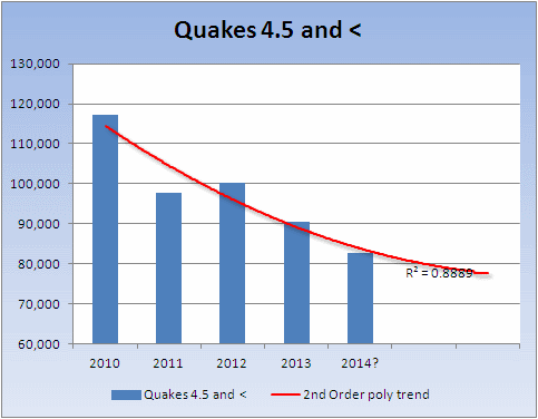
It was mentioned about the M7+ but I do not agree with your statement that there has been an increase in quakes under 4.5. From 2010 (Jan 01) to present ANSS reports 419,890 events between magnitude 0 and 4.5 or which 14,270 are in 2014 and we can discount for the moment
2010 117,208
2011 97,720
2012 100,294
2013 90,398
If i remove the March 05 entries to give a round number of days in 2014 (63), then the total of 14,249 so far extrapolated forwards to the end of the year gives us 82,553.
I am sorry but I just cannot agree with the statement you made. There appears to be a very clear downward trend.
ETA: One does like a little chartypoo so here is one
Possibly, or as Phoenix said, less energy going into the system.
not the rubbing together that causes quakes, but the actual plates themselves moving together but tearing and ripping apart within
Inevitably when the porridge rises at the boil some of the surface of the porridge slides back down at the side of the pan. If there was a big lump of congealed porridge blocking it's path it would descend under that. But what the plate tectonics people are missing is that the porridge is rising. Most of the expansion is taken up by a change in overall volume and a little by 'subduction' but the suggestion that this is by slab pull anywhere at all is totally daft. It has to be slab push if it is anything at all.
Since the amount of energy required as alluded to by Phoenix is way more than the available energy to simply stuff the crust of the porridge back down the side of the pan again because of it's own weight something else has to be happening. I believe the eventual answer will be a mix of plate tectonics, surge tectonics, expanding earth and EMST. For that to be agreed many of the Church of Geology are going to have to choke on their dogma, but eventually it will change just as the AGW fiasco will recede as realistic models of what is happening eventually surface that are untampered with.
What is transpiring? Pipeline explosions, train derailments, hydroelectric dam cracks, underground storage collapses, land cracks, sinkholes, landslides, land deformation (like Yellowstone), water main breaks, building implosions, bridge collapses, loud thunderous booms, trumpet sounding vibration noises, hums, rivers disappearing, re-emerging islands, small tremors and dormant volcanoes awakening. Earth crust shifting could be causation for these phenomenon, including the roaming plumes of methane and hydrogen sulfide gases that are causing explosions, fires, poisonings and even death because when the land fractures below, these gases are most likely escaping into the atmosphere.
Now there is a bunch of problems!!! The other day I was out walking in the hills as I do and I heard sky noises. I have heard them before and strangely they are always when it is windy. By chance I happened to be passing a farm gate with big steel posts open at the top. As I walked past the direction of the sky noise fell behind me. Curious I approached the gate. The posts were the source of the sky noise I have heard so often. Think of blowing on the top of a bottle to produce a sound. Sometimes the explanation for this is not as complex as it may appear. Get Mr Occam to show you his razor.
...It was just mentioned the other day that it has been a very long time since there were any quakes above 7.0 and an even longer drought for the big ones, 8 and above, but at the same time, there seems to be quite an increase in small tremors and swarms of quakes under 4.5
(Bold by me)
It was mentioned about the M7+ but I do not agree with your statement that there has been an increase in quakes under 4.5. From 2010 (Jan 01) to present ANSS reports 419,890 events between magnitude 0 and 4.5 or which 14,270 are in 2014 and we can discount for the moment
2010 117,208
2011 97,720
2012 100,294
2013 90,398
If i remove the March 05 entries to give a round number of days in 2014 (63), then the total of 14,249 so far extrapolated forwards to the end of the year gives us 82,553.
I am sorry but I just cannot agree with the statement you made. There appears to be a very clear downward trend.
ETA: One does like a little chartypoo so here is one
Does it make sense that maybe because of the tearing and ripping of the plates themselves from say something like crust displacement, there may be less pressure on the plate boundaries, thus, a lack of major earthquakes?
Possibly, or as Phoenix said, less energy going into the system.
edit on 5/3/2014 by PuterMan because: Ah, the inevitable speeling erra
edit on 5/3/2014 by PuterMan because: To add a
chart/graph
edit on 5/3/2014 by PuterMan because: To add clarity to the mangled English that I type.
reply to post by PuterMan
THX THX.
I much appreciated your summary. I think you expressed it better than ever.
I agree that those of the Church of Geology will have to . . . swallow their dogma . . . in order to articulate a more accurate description of what's really going on.
THX THX.
I much appreciated your summary. I think you expressed it better than ever.
I agree that those of the Church of Geology will have to . . . swallow their dogma . . . in order to articulate a more accurate description of what's really going on.
Thanks for your replies, guys. It's a lot to think about. Also, I'm not sure what to believe on the quakes because some say they are increasing
while others say they aren't. Some claim that the USGS has changed their way of tracking. As of Jan. 1, 2009, they don't track small quakes so how
do we really know the total number. Your graph shows a huge decrease and that falls in line with the USGS dates of change. Some claim that they are
hoping to hide something by not tracking the small quakes anymore so we won't see the increase. You say there are 14,000 small quakes so far this
year, how many are in Oklahoma alone? Hard to believe that there is such a significant, undeniable increase in OK and yet the numbers are dropping so
much so in the other areas. Seems California has been having quite a few swarms lately, so that doesn't seem to follow in line with a decrease. Oh
well, what do I know, not much, I just like to read. Maybe I'm reading in the wrong places, but then again, maybe I'm not.
reply to post by Rezlooper
I will take a further look at this but surely your very statement indicates the data is correct dos it not?
USGS do not report < 4.5 generally outside the US and therefore the bulk of these quakes are going to be in the US and not outside it, but OK I take on board what you are saying and will be a little more 'scientific' about the numbers. By the way European data has the same problems in that areas have been added clouding the figures.
Back to you later.
As of Jan. 1, 2009, they don't track small quakes so how do we really know the total number.
I will take a further look at this but surely your very statement indicates the data is correct dos it not?
USGS do not report < 4.5 generally outside the US and therefore the bulk of these quakes are going to be in the US and not outside it, but OK I take on board what you are saying and will be a little more 'scientific' about the numbers. By the way European data has the same problems in that areas have been added clouding the figures.
Back to you later.
Update on Ryukyu Islands. Japan M6.4 aftershocks post by muzzy
Still not many aftershocks from that Ryukyu Islands. Japan M6.4, only 6 in the immediate area, and all below 3.0, to 04/03/2014 14:45:36UTC.
however there was a M5.0, with 7 of its own aftershocks, 119.6 km south of the M6.4, north of Zamami Island, closer in and west of Okinawashima Is., 6 hours, 16 minutes and 8 seconds after the M6.4.
interactive map JMA reviewed data since 02/03/2014 00:01:54 UTC.
Given that wiki&usgs say;
Aftershocks are formed as the crust around the displaced fault plane adjusts to the effects of the main shock.
The pattern of aftershocks helps confirm the size of area that slipped during the main shock.
range of aftershock activity can be 1-2 rupture lengths distance from the mainshock.
(but how long was the rupture length?)
The M6.4 was quite deep at 115.7km, as are the aftershocks within 10km from it, and it was just south of the Continental Rift Boundry/Transform Fault.
I think the M5.0 is a separate event, rather than an aftershock, but perhaps "triggered" by the M6.4.
edit on 03u636314 by muzzy because: add reference
I think there was an earthquake in east-central Ohio within the past hour. Let me grab some pictures...
from the transportable array (something is showing at the far right of the image below)
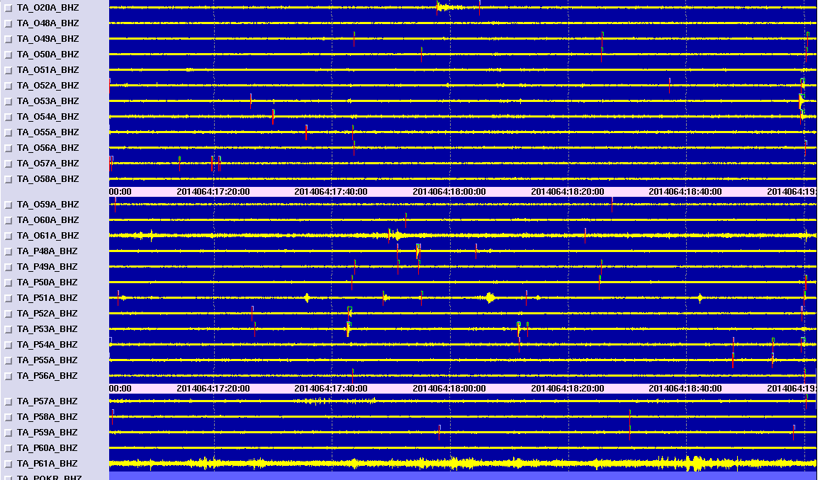
It looks like it originated closest to O53A which is in New Philadelphia, OH around 18:58 UTC. They have been fracking near there for at least a year (I know an engineer who worked out of that area last summer), but I had thought they had stopped the injection disposal wells--maybe not.
Link to IRIS helicorder
Hmm, it's been almost an hour since I started to post this (had to take a call & walk the puppy), and it isn't listed on USGS. Maybe it was a sonic boom? It looks like an earthquake signature to me.
ETA: I just wanted to say, the only reason I even looked for this quake was because I felt minute rumbling for a few seconds--but I'm a 4-1/2 hour drive away. Weird
from the transportable array (something is showing at the far right of the image below)
It looks like it originated closest to O53A which is in New Philadelphia, OH around 18:58 UTC. They have been fracking near there for at least a year (I know an engineer who worked out of that area last summer), but I had thought they had stopped the injection disposal wells--maybe not.
Link to IRIS helicorder
Hmm, it's been almost an hour since I started to post this (had to take a call & walk the puppy), and it isn't listed on USGS. Maybe it was a sonic boom? It looks like an earthquake signature to me.
ETA: I just wanted to say, the only reason I even looked for this quake was because I felt minute rumbling for a few seconds--but I'm a 4-1/2 hour drive away. Weird
edit on 3/5/2014 by Olivine because: (no reason given)
edit on 3/5/2014 by Olivine because: (no reason given)
more on Ryukyu Islands post by muzzy
"triggering" is often mentioned here on ATS from time to time, but it it a valid observation?
While looking at that 02.03.2014 Okinawa-shima Is M6.4, on USGS (gads!!??) they have a Historical Events Map for it, I noticed a M5.7 near this one in 2007 (#18 on the USGS map) and decided to check it out on JMA (JMA data only goes back to 2002 so all the others on the west side of the subduction zone had to be discounted for comparison value because they were too old)
Firstly USGS are 23km out (to the west of JMA) with the location.
This is the event, 2007-04-20 19:37:58 Off Okinoerabu-shima Island, NEAR OKINAWAJIMA ISLAND, Ryukyu Islands
which itself was either an aftershock or "triggered" event from a series of M6's NW off Miyako-jima Island, Southwestern Ryukyu Islands the same day (shown as #17 on the USGS map);
M6.3 at 20/04/2007 00:26:40 NW OFF MIYAKOJIMA ISLAND
M6.7 at 20/04/2007 01:45:55 NW OFF MIYAKOJIMA ISLAND (Mainshock?)
M6.1 at 20/04/2007 02:23:32 NW OFF MIYAKOJIMA ISLAND
The M5.7 at 2007-04-20 19:37:58 north of Okinoerabu-shima Island just popped off 19:11:18 (hh:mm:ss) after the M6.3 at 20/04/2007 00:26:40 NW OFF MIYAKOJIMA ISLAND, no other triggers in that spot in the interim.
There were 21 aftershocks of that M5.7 over the next 7 days (on a 7 day download)
here is an interactive map of what I'm talking about.
399 km between the initial M6.3 and the "triggered" M5.7
is that too far?
based on the "rupture length" of the 3 x M6's at approx 60km, (a bit more if you put a curve in it), which I calculated from the aftershocks in the 7 days after, the theory that "range of aftershock activity can be 1-2 rupture lengths distance from the mainshock", tends to discount the M5.7 as an "aftershock", as it is way out of the 120km (2x60km) range of the rupture length, and it was likely a "triggered" event.
I rest ma case M'Lord.
* I noticed on that interactive map from 04/2007 (7 days worth) the lack of earthquakes in the Hitachi Mountains (I don't know what their real name is, but they are just north of Hitachi (which is NE of Tokyo, on the east coast)), compared to recent times. The daily maps I'm doing on GSAIM have heaps of them in the NEID Preliminary data every day, and even on JMA Reviewed data there would be about a dozen per day average over 7 days in those mountains now, I wonder if those were "triggered" by the 11/2011 M9.0 Tohoku monster? and are ongoing since then?
Interesting.
edit on 03000000636314 by muzzy because: too many words, its hard to see spelling mistakes. The red wiggly lines under misspelled words only
show up when you open it again for editing.
edit on 03u636314 by muzzy because: there would be about per a dozen per day average???
doh, too many per's
reply to post by Rezlooper
How many in Oklahoma alone?
Apparently 144
BUT and this is a BIG BUT (not BUTT)
USGS or ANSS is selective in what it catalogues. Oklahoma is NOT and area that is catalogued below Mag 2 (There is a single 1.6 in that list)
This makes it very hard as you rightly observed since Yellowstone merits cataloguing down to -0.1 as does California.
I did try collecting the Oki data but it was erratic.
More later as I am having a problem with the local Chiile data
How many in Oklahoma alone?
Apparently 144
Your search parameters are:
catalog=ANSS
start_time=2014/01/01,00:00:00
end_time=2014/03/05,20:29:18
minimum_latitude=34
maximum_latitude=38
minimum_longitude=-101
maximum_longitude=-95
minimum_magnitude=0
maximum_magnitude=10
event_type=E
BUT and this is a BIG BUT (not BUTT)
USGS or ANSS is selective in what it catalogues. Oklahoma is NOT and area that is catalogued below Mag 2 (There is a single 1.6 in that list)
This makes it very hard as you rightly observed since Yellowstone merits cataloguing down to -0.1 as does California.
I did try collecting the Oki data but it was erratic.
More later as I am having a problem with the local Chiile data
Do any of these seismos show harmonic tremor???
w.isthisthingon.org/Yellowstone/daythumbs.php
w.isthisthingon.org/Yellowstone/daythumbs.php
Decent sized one off the northern coast of the DR:
earthquake.usgs.gov...
M5.0 - 102km NE of Punta Cana, Dominican Republic 2014-03-06 21:56:49 UTC
Location
19.284°N 67.774°W depth=43.0km (26.7mi)
earthquake.usgs.gov...
Nyiah
Decent sized one off the northern coast of the DR:
M5.0 - 102km NE of Punta Cana, Dominican Republic 2014-03-06 21:56:49 UTC
Location
19.284°N 67.774°W depth=43.0km (26.7mi)
earthquake.usgs.gov...
Downgraded to 4.6...there has been a few moderate sized quakes in that area in the last several months.
The most I have seen in the last 3 years of paying attention....this area capable of 8+ monsters
new topics
-
Is the origin for the Eye of Horus the pineal gland?
General Conspiracies: 1 hours ago -
Man sets himself on fire outside Donald Trump trial
Mainstream News: 1 hours ago -
Biden says little kids flip him the bird all the time.
2024 Elections: 2 hours ago -
The Democrats Take Control the House - Look what happened while you were sleeping
US Political Madness: 2 hours ago -
Sheetz facing racial discrimination lawsuit for considering criminal history in hiring
Social Issues and Civil Unrest: 2 hours ago -
In an Historic First, In N Out Burger Permanently Closes a Location
Mainstream News: 4 hours ago -
MH370 Again....
Disaster Conspiracies: 5 hours ago -
Are you ready for the return of Jesus Christ? Have you been cleansed by His blood?
Religion, Faith, And Theology: 7 hours ago -
Chronological time line of open source information
History: 8 hours ago -
A man of the people
Medical Issues & Conspiracies: 10 hours ago
top topics
-
In an Historic First, In N Out Burger Permanently Closes a Location
Mainstream News: 4 hours ago, 14 flags -
The Democrats Take Control the House - Look what happened while you were sleeping
US Political Madness: 2 hours ago, 9 flags -
Thousands Of Young Ukrainian Men Trying To Flee The Country To Avoid Conscription And The War
Other Current Events: 15 hours ago, 8 flags -
A man of the people
Medical Issues & Conspiracies: 10 hours ago, 8 flags -
Biden says little kids flip him the bird all the time.
2024 Elections: 2 hours ago, 6 flags -
Man sets himself on fire outside Donald Trump trial
Mainstream News: 1 hours ago, 5 flags -
12 jurors selected in Trump criminal trial
US Political Madness: 17 hours ago, 4 flags -
4 plans of US elites to defeat Russia
New World Order: 11 hours ago, 4 flags -
Are you ready for the return of Jesus Christ? Have you been cleansed by His blood?
Religion, Faith, And Theology: 7 hours ago, 3 flags -
Sheetz facing racial discrimination lawsuit for considering criminal history in hiring
Social Issues and Civil Unrest: 2 hours ago, 3 flags
active topics
-
Do we live in a simulation similar to The Matrix 1999?
ATS Skunk Works • 27 • : purplemer -
Thousands Of Young Ukrainian Men Trying To Flee The Country To Avoid Conscription And The War
Other Current Events • 27 • : Xtrozero -
Is the origin for the Eye of Horus the pineal gland?
General Conspiracies • 2 • : nugget1 -
12 jurors selected in Trump criminal trial
US Political Madness • 86 • : ImagoDei -
911 emergency lines are DOWN across multiple states
Breaking Alternative News • 8 • : nugget1 -
Marjorie Taylor Greene Files Motion to Vacate Speaker Mike Johnson
US Political Madness • 64 • : interupt42 -
The Democrats Take Control the House - Look what happened while you were sleeping
US Political Madness • 20 • : CriticalStinker -
Man sets himself on fire outside Donald Trump trial
Mainstream News • 17 • : FlyersFan -
Biden says little kids flip him the bird all the time.
2024 Elections • 8 • : Astrocometus -
Are you ready for the return of Jesus Christ? Have you been cleansed by His blood?
Religion, Faith, And Theology • 18 • : mysterioustranger