It looks like you're using an Ad Blocker.
Please white-list or disable AboveTopSecret.com in your ad-blocking tool.
Thank you.
Some features of ATS will be disabled while you continue to use an ad-blocker.

Tremors felt 45 miles away from Bayou Corne Sinkhole!
page: 34share:
reply to post by Kituwa
Welcome to the thread. That was a great video and I also bookmarked most of the links under it on YouTube.
BTW - I also recommended you for an applause from the forum moderator in addition to giving you a star.
Welcome to the thread. That was a great video and I also bookmarked most of the links under it on YouTube.
BTW - I also recommended you for an applause from the forum moderator in addition to giving you a star.
edit on 4-12-2012 by happykat39
because: added info
We are getting slammed by rain right now. Really bad downpour. We may see some activity soon. As if the ground isn't soft enough, we get this. My
estimate so far is over 5 inches of rain so far.N
edit on 4-12-2012 by CajunBoy because: (no reason given)
reply to post by CajunBoy
Thanks for the weather update CB, an anxious to see how the sinkhole reacts. I bet we will see an enlargement but won't get flyover pics for
quite awhile.
reply to post by Kituwa
Thanks for linking the video. Very informative. What are those fires are the end??? I am going to go google for more information and see exact location.
Thanks for linking the video. Very informative. What are those fires are the end??? I am going to go google for more information and see exact location.
Originally posted by CajunBoy
We are getting slammed by rain right now. Really bad downpour. We may see some activity soon. As if the ground isn't soft enough, we get this. My estimate so far is over 5 inches of rain so far.Nedit on 4-12-2012 by CajunBoy because: (no reason given)
CB,
What do you expect may happen with all the rain?
GEOLOGICAL UPHEAVAL: Are Monster Sinkholes An Indication That Major Earth Changes Are Coming Along The New Madrid Fault?
SOURCE
The very thought of anything setting the New Madrid fault off again scares the snot out of me. Back in the winter of 1811/1812 there were very few people living in the area so loss of life was minimal. If it were to happen again today the loss of life would number in the millions. It would also effectively cut the United States into two pieces even if it didn't open up to form an inland sea as in Edgar Cayce's prophecy.
SOURCE
That is why so many people are so concerned about the monster sinkholes that have appeared in the region in recent months. For example, a massive sinkhole down in Louisiana is now over 8 acres in size and it has forced hundreds of people to flee from their homes. You can see video of the Louisiana sinkhole right here. Over in Ohio, a giant sinkhole has suddenly formed that is more than 30 feet deep and that is the size of four football fields. That sinkhole caused part of State Route 516 to collapse and authorities say that it will likely be closed for many months. You can see video of the gigantic sinkhole in Ohio right here. Are these monster sinkholes an indication that major earth changes are coming along the New Madrid fault?
NOTE: Links are active at the source site.
The very thought of anything setting the New Madrid fault off again scares the snot out of me. Back in the winter of 1811/1812 there were very few people living in the area so loss of life was minimal. If it were to happen again today the loss of life would number in the millions. It would also effectively cut the United States into two pieces even if it didn't open up to form an inland sea as in Edgar Cayce's prophecy.
reply to post by riverwild
same thing that happens every time it rains. It has rained 3 times since the sinkhole formed and each time we get major events. First time it rained we seen seismic activity the day after. Second time it rained we get H2S the day after. This is the third time and God only knows what will come out of this.
I just don't see how the Bayou Corne sinkhole can be related to the New Madrid fault line when it was a man made disaster. Though when it comes to earthquakes in Louisiana, the biggest one happened in White Castle, LA back in the day. It measured around 4.0. White Castle is just 15 or so miles north of the sinkhole.
edit on 5-12-2012 by CajunBoy because: (no reason given)
Originally posted by CajunBoy
reply to post by riverwild
same thing that happens every time it rains. It has rained 3 times since the sinkhole formed and each time we get major events. First time it rained we seen seismic activity the day after. Second time it rained we get H2S the day after. This is the third time and God only knows what will come out of this.
I just don't see how the Bayou Corne sinkhole can be related to the New Madrid fault line when it was a man made disaster. Though when it comes to earthquakes in Louisiana, the biggest one happened in White Castle, LA back in the day. It measured around 4.0. White Castle is just 15 or so miles north of the sinkhole.edit on 5-12-2012 by CajunBoy because: (no reason given)
Yeah CB, I don't buy the connection between the Bayou Corne sinkhole and the New Madrid myself. At least not in a causative way. But I think the point of the piece is that there are a lot of sinkholes opening up along the New Madrid, many of which are under reported in the national news.
But here is where I do see a connection. The area around the B P Deepwater Horizon disaster is still very unstable and a case, albeit a weak one, can be made for a connection through the salt strata and dome system to the New Madrid. But I think if the Bayou Corne sinkhole is involved at all it will just be getting taken along for the ride and not, by itself, be the cause of anything on that scale.
But if, in the very long run, the bayou Corne sinkhole does completely collapse and take the rest of the salt dome, and possibly other geological structures, with it, then there is a possibility of it causing earthquakes that could radiate out to the New Madrid. But at this time almost everything on a major disaster scale is still conjecture and somewhat "educated" guesses.
The only thing I am really concerned about is the activity along the New Madrid fault system from the upper Midwest to the gulf when viewed in light of the Edgar Cayce prophecy. He got way too much right to not be at least a little concerned about even the wildest of his prophecies.
edit on
5-12-2012 by happykat39 because: added info
reply to post by happykat39
Happy, you have to have listened to Coast to Coast lol. They talk about Edgar Cayce from time to time and have been spot on with his predictions.
As for the New Madrid Fault line and the Mississippi, it gets a little fuzzy on where the fault line runs after the Red River meets with the Mississippi. Over millions of years the Mississippi has diverted directions 3 times in southeast Louisiana. The original path is present day Bayou Lafourche. After a while, the land got built up around the river and it diverted. It then diverted and created the Atchafalaya Basin. Then after that got built up it diverted for a last time and we get the river we have today. Not many people know the geological story. Which raises the question to me, if the the fault line follows the Mississippi, which path does it take. Bayou Lafourche, Atchafalya River, or the Mississippi river now.
Do you have a map of the New Madrid fault line in Louisiana?
The actual New Madrid fault does not extend into Louisiana. However, it is a part of a fault system that extends from the great lakes to the gulf. And
the map in the video below shows Louisiana as one of the states that would suffer massive destruction from the New Madrid.
If you consider the entire fault system, of which the New Madrid is only a part, then you begin to understand the danger if Edgar Cayce is right.
Here is an interesting video of the New Madrid and the other faults, some not widely known about, in the continental United states.
For some reason the video won't show so here is the direct YouTube LINK
I have occasionally watched Coast to Coast, but my info on the New Madrid prophecy came from other sources. There is an official Edgar Cayce web site but it has been turned into a new age psychobabble load of garbage by the people who took it over. Here is a LINK to one of their pages with a Bio on Cayce.
edit on 5-12-2012 by happykat39 because: correction
edit on 5-12-2012 by happykat39 because: added info
edit
on 5-12-2012 by happykat39 because: typo
reply to post by happykat39
happykat, thanks for the pic
and the offer of a tutorial, however, please note that i cannot view video at all (on this puter), hence, a tutorial isn't gonna help me one bit but thanks anyway.
that's really looking bad and from what CB says about more rain, i would not be anywhere within 3 miles of that thing.
when it settles again, it's gonna be a big one.
am glad to read more ppl are pushing for national exposure but i seriously doubt they'll get very far until TPTB desire such.
am not delving into the potential doom/gloom or prophesies of old as this sinkhole presents enough of its own.
personally, i'm curious how the minden explosive mess will eventually play into this disaster scenario. i'm not sure how yet, but i'm comfortably confident that it will.
reply to post by happykat39
I brought this up a few pages ago but got shot down, I have heard the theory going around the net.
I brought this up a few pages ago but got shot down, I have heard the theory going around the net.
Originally posted by CajunBoy
reply to post by riverwild
snip
I just don't see how the Bayou Corne sinkhole can be related to the New Madrid fault line when it was a man made disaster. Though when it comes to earthquakes in Louisiana, the biggest one happened in White Castle, LA back in the day. It measured around 4.0. White Castle is just 15 or so miles north of the sinkhole.edit on 5-12-2012 by CajunBoy because: (no reason given)
This image shows the NMSZ in a regional context:
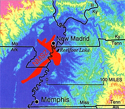
As you can see, the New Madrid Seismic Zone is quite far north of the are in which the sinkhole has developed. Now, that is not to say that Louisiana would be unaffected if this fault zone were to rupture in a big way once more, it most certainly would. I just don't see how the sinkhole could have any appreciable affect on the fault zone.
This image shows a 3d representation of the underlying rock strata with a bit of vertical exaggeration:
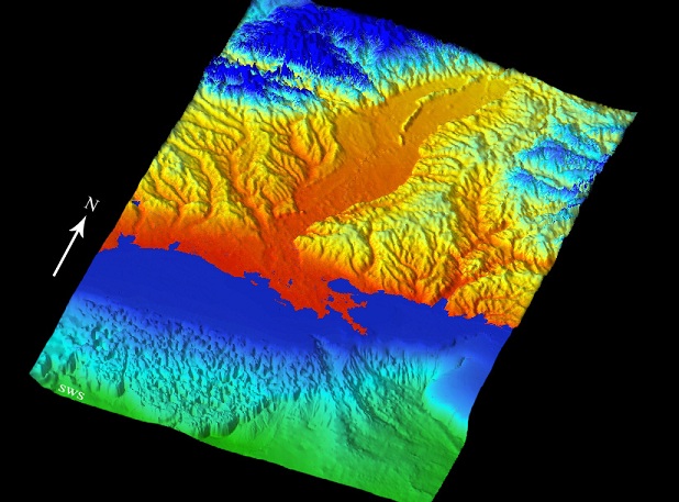
This is the Mississippi River Embayment, in which the Old Man River runs and has, as been mentioned, changed courses several times.
The following image is a cross section of a typical section of the embayment:
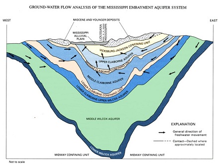
You can clearly see the several layers of aquifer and sediments that make up the river plain. It also shows the direction of the flow of water through the system, which may play into some of the unseen forces acting upon the sinkhole.
And I though this image which shows historic shorelines to be very interesting:
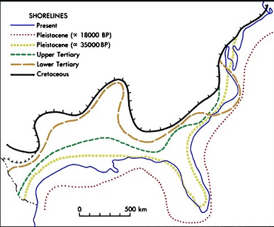
As you can see, the prior shorelines were many many miles further out in the more recent past and then also many many miles further in in the more distant past. Really gives you something to consider.
All above-referenced images taken from The Mississippi Embayment The Quaternary Canvas
Not directly related, but of interest i thought is this image:
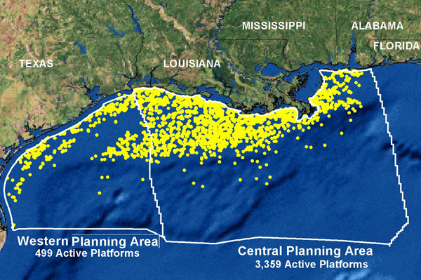
I don't remember exactly where it is from, it's in my uploads section. A bit of googling would turn it up at some petroleum database, I am certain.
Anyway, if you notice the number of producing wells just off the shore and think about the effect removing all those millions (billions?) of gallons of crude oil would have on all of the layers above it boggles the mind.
All of the upper layers continue to push downward, and the entire Mississippi River Valley is not much more than one huge sediment glacier that is slowly flowing into the Gulf of Mexico. Something's going to give at some point, and when it does I hope that people are as safe as can be.
Is our Irish friend still following this? If you are tell me your thoughts.
Though I don't like idahopicker's videos all to much, a lot of false information time in and time out. This one caught my attention though, would his assessment be correct? His video is getting posted on things like The Examiner and this guy is far from a geologist or petroleum engineer.
This video may or may not been posted.
Though I don't like idahopicker's videos all to much, a lot of false information time in and time out. This one caught my attention though, would his assessment be correct? His video is getting posted on things like The Examiner and this guy is far from a geologist or petroleum engineer.
edit on 6-12-2012 by CajunBoy because: (no reason given)
This video may or may not been posted.
edit on 6-12-2012 by CajunBoy because: (no reason given)
Originally posted by timetothink
reply to post by happykat39
I brought this up a few pages ago but got shot down, I have heard the theory going around the net.
I looked for your post but couldn't find it. But if there was a claim that the New Madrid caused the sinkhole that is dead wrong. The only connection between the New Madrid and the Bayou Corne sinkhole is the very slight possibility that a major seismic event at the sinkhole due to a complete collapse, and possibly including activity from the B P Deepwater disaster, could destabilize the faults that connect to the New Madrid and cause a cascade effect earthquake.
The Bayou Corne sinkhole itself is totally a man made disaster and has no connection to any seismic activity anywhere except that caused by the forming and collapse of the sinkhole itself.
reply to post by CajunBoy
Is our Irish friend still following this? If you are tell me your thoughts. Though I don't like idahopicker's videos all to much, a lot of false information time in and time out. This one caught my attention though, would his assessment be correct? His video is getting posted on things like The Examiner and this guy is far from a geologist or petroleum engineer.
IdahoPicker is making some spectacular claims. But they stand or fail on a single statement he made in his video. His claim was that each of the helicorder locations is only able to pick up disturbances from directly underneath it. There are two distinct possibilities...
1 - He is right and the fact that most of the helicorder charts show the same thing is indicative of seismic activity under the entire salt dome and could be showing a collapse of the entire dome.
2 - He is wrong and the similar helicorder readings just reflect the fact that the helicorders are sensitive enough in all planes, horizontal and vertical, to record the same data.
Here is my take on it. Someone in one of the videos that has been posted several pages back showed that there is a time difference between the helicorder readings in different locations that show a single event propagating in space and time from a single location. The stronger reading would be the location of the event and weaker readings would show at slightly delayed times in the other helicorder readings. The farther from the original disturbance the later on the helicorder the same trace will show.
So while he may or may not be right about the complete collapse of the entire salt dome, his evidence does not support it.
====================================================
This just in...
Breaking news, we now know the cause of the sinkholes; it's badgers.
SOURCE
Badgers blamed for Leicester road collapse
The closure of a country lane in Leicestershire which collapsed underfoot is being blamed on badgers.
The animals had tunneled under the surface of the 1.5-mile lane between Somerby and the hamlet of Newbold, causing two large craters.
Could it be that the furry little critters were just trying to find fuel to heat their cold damp burrows this winter? Just imagine how nice and toasty warm 1.5 million barrels of liquid butane would have kept them.
edit on 6-12-2012 by happykat39 because: (no reason given)
What is happening under the salt dome...
Some straight thoughts from a twisted mind...
Could there be a small similarity between the Bayou Corne sinkhole and the Lake Peigneur disaster?
First let's look at the Lake Peigneur disaster. That was caused by a drilling rig being positioned wrong and drilling into a very large multi level salt mine. The water at first entered the salt mine at a relatively slow rate. But due to the massive volume of the salt mine and the plentiful supply of high pressure fresh water (not high pressure at the surface but at the depth of the salt mine breach the pressure would have been enormous) The salt around the breach was rapidly eroded until the drainage caused a massive whirlpool that sucked whole barges into it. This all happened over a matter of hours.
Now let's look at the Bayou Corne sinkhole...
From published reports the same thing that caused the Lake Peigneur disaster caused the Bayou Corne sinkhole. In other words, someone drilled into the salt mine and someone drilled too close to the salt dome. But the salt dome breach was smaller and did not open up a hole in the bottom of a lake. On top of that the salt dome was much smaller in volume and already contained other substances like brine and stored liquids. Unlike the Lake Peigneur disaster where there was a huge open and empty space for the water to drain into, the Bayou Corne breach was smaller and tapped into a space already full of something.
So now why do I claim a similarity?
Both involve water and salt. Water dissolves salt. The high rate of water flow in Lake Peigneur dissolved the salt very quickly. There is now evidence of water flow through the bayou Corne salt cavern as witnessed by the incursion of chloride into the aquifer. Slow water flow dissolves salt more slowly.
So here is my final question...
Even though there are differences in the two incidents that will keep them from being a perfect one on one match is it possible that what we are seeing in Bayou Corne is a super slow motion repeat of what happened at lake Peigneur and could it, over an extended time period, be just as much of a disaster?
edit on 6-12-2012 by happykat39 because: (no reason given)
reply to post by happykat39
So far all we know is that the Bayou Corne sinkhole was caused buy a cavern that was drilled to close to the salt dome wall and a MIT pressure test blew out the side.
I guess you can say one event was a puncture and the other was a blowout. Also with the lake event, the drill site was at the bottom of a lake with far more down pressure than what we have here at Bayou Corne. The amount of downward pressure is not the same as it was at Lake Penguir. Another big difference, the amount of space the water has to fill in. Last difference is though they were drilling for oil at the lake, the draining of the lake never leaked hydrocarbons. Bayou Corne just got unlucky and the oil is coming to them via "Big Hum."
This disaster isn't going to be as spectacular as the only recorded waterfall in Louisiana. Not only that, Lake Penguir didn't have any deaths. We don't know what this hole is going to do.
Also.... Here we go again, all it takes is a nice amount of rain. Just goes to show ya riverwild lol.
theadvocate.com...
edit on 6-12-2012 by CajunBoy because: (no reason given)
edit on 6-12-2012 by CajunBoy because: (no reason given)
watch this thread daily. New Orleans, here, and interestingly, this is still the best info out threre in regards to our sinkhole. Thanks to everyone
for providing so much information
having said that, just wanted to shoot something CB's way, nodding to his good info and participation here. Do you remember a few stories on local news (WDSU) a few months back about a "salt wedge" traveling up the MS river, and causing some problems with those getting their water supply from the river? The "fix" was building up a sand or silt bar to slow it down and provide some filtration, I believe, if I remember correctly.
I mention this, obviously, because it was interesting it was salt. And also, when one drives over the area on I-10W
and 55N before and after the Bonne Carre Spillway, there are oodles of dying cypress trees, which we were told over the years died because of salt water incursion, due to the construction of the spillway and the army corps of engineers solutions to flooding. Of course, there are probably many on this thread that may not realize what a huge issue this is here in Southern Louisiana, and particularly since Katrina. New Orleans is a former swamp, after all, surrounded still by water, between the river and Lake Pontchartrain, with a system of levees and the spillway, nodding here also to the Morganza Spillway, as well as the Bonne Carre, all of which "push" that water back to make dry land and the cities possible.
The "salt ridge" on the river really peaked my interest. It's been an issue, I believe, the last two Augusts. Then we have this sinkhole, and it happens to be related to the seeming liquefaction of a salt dome. Water moving through salt easily dissolves and dislodges, and then the salt will show up other places, logically.
Another thing I would like to bring up just for some of the better minds present to think about is that it was suggested at the time that the Macondo well had drilled into a batholyth. If one researches the analysis of the geological formation called a batholyth, the salt domes would be a feature of a particular level, geologically of the said batholith. If those of you interested, research this particular formation, I think you will find interesting implications in regards to everything discussed in this thread.
Again, thanks for informing me as to all the happenings.
Originally posted by CajunBoy
reply to post by happykat39
This disaster isn't going to be as spectacular as the only recorded waterfall in Louisiana. Not only that, Lake Penguir didn't have any deaths. We don't know what this hole is going to do.
Also.... Here we go again, all it takes is a nice amount of rain. Just goes to show ya riverwild lol.
theadvocate.com...
edit on 6-12-2012 by CajunBoy because: (no reason given)edit on 6-12-2012 by CajunBoy because: (no reason given)
I have been waiting to see what surprise would be coming from the rain. Now two wells have detected Hydrogen sulfide, the article doesn't say location of these wells, hopefully that information wil becoming out soon. This second detection really bothers me. We had a burp from the sinkhole that spewed things up. We have deadly gas. Did anyone read the comment below the article(though I think the info was slightly wrong)? This is what I have been worried about. Gas cloud kills Cameroon villagers
This area has been compromised, the gasses are not secure anymore therefore what is to prevent the sinkhole from burping up a cloud of hydrogen sulfide? Please note in the article I linked:
Recall the sinkhole dropped for awhile before it belched. The floor is raising- do I really believe that it is debris- No. Do I speculate that something is building- yes.
A subsequent investigation of the lake showed the water level to be four feet lower than what it had previously been.
new topics
-
What is the white pill?
Philosophy and Metaphysics: 1 hours ago -
Mike Pinder The Moody Blues R.I.P.
Music: 2 hours ago -
Putin, Russia and the Great Architects of the Universe
ATS Skunk Works: 5 hours ago -
A Warning to America: 25 Ways the US is Being Destroyed
New World Order: 9 hours ago
top topics
-
President BIDEN's FBI Raided Donald Trump's Florida Home for OBAMA-NORTH KOREA Documents.
Political Conspiracies: 15 hours ago, 34 flags -
A Warning to America: 25 Ways the US is Being Destroyed
New World Order: 9 hours ago, 18 flags -
Mike Pinder The Moody Blues R.I.P.
Music: 2 hours ago, 5 flags -
Is AI Better Than the Hollywood Elite?
Movies: 16 hours ago, 4 flags -
What is the white pill?
Philosophy and Metaphysics: 1 hours ago, 4 flags -
Putin, Russia and the Great Architects of the Universe
ATS Skunk Works: 5 hours ago, 2 flags -
Maestro Benedetto
Literature: 16 hours ago, 1 flags
active topics
-
Gaza Terrorists Attack US Humanitarian Pier During Construction
Middle East Issues • 73 • : FlyersFan -
SETI chief says US has no evidence for alien technology. 'And we never have'
Aliens and UFOs • 76 • : andy06shake -
Russia Ukraine Update Thread - part 3
World War Three • 5734 • : Arbitrageur -
So this is what Hamas considers 'freedom fighting' ...
War On Terrorism • 264 • : FlyersFan -
Candidate TRUMP Now Has Crazy Judge JUAN MERCHAN After Him - The Stormy Daniels Hush-Money Case.
Political Conspiracies • 792 • : Threadbarer -
What is the white pill?
Philosophy and Metaphysics • 6 • : kwaka -
Putin, Russia and the Great Architects of the Universe
ATS Skunk Works • 19 • : FlyersFan -
Starburst galaxy M82 - Webb Vs Hubble
Space Exploration • 7 • : Scratchpost -
Truth Social goes public, be careful not to lose your money
Mainstream News • 134 • : lilzazz -
One Flame Throwing Robot Dog for Christmas Please!
Weaponry • 11 • : Therealbeverage