It looks like you're using an Ad Blocker.
Please white-list or disable AboveTopSecret.com in your ad-blocking tool.
Thank you.
Some features of ATS will be disabled while you continue to use an ad-blocker.

Tremors felt 45 miles away from Bayou Corne Sinkhole!
page: 33share:
Originally posted by AuntB
Honor, I am basically computer illiterate. I am not sure how to make stills of the fly over but maybe someone else can. Anyone know how to do that??? Thanks.
Originally posted by Honor93
AuntB, would you or some other skilled poster PLEASE post some stills from that video that i and others cannot view ? purty please.
Originally posted by AuntB
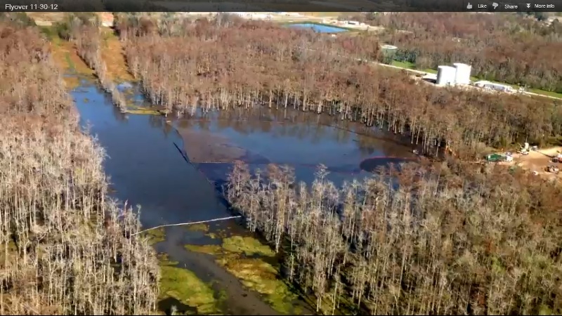
Flyover 11-30-12
Latest "flyover". Notice they really don't fly over the hole. They stay back. What I want is to see how far that water goes back into the trees. Also, I would like them to pan all the dead trees on the left hand side.
It's not hard at all. I will post a tutorial later in the appropriate forum and put a link here.
Here is a screenshot of the flyover video posted by AuntB.
Scroll the picture left to right to see the whole thing. (scroll bar at bottom of picture, not screen)
edit on 1-12-2012 by happykat39 because: added info
Thank you Happykat. Looking at that picture, it seems to me that the water extends quite far back into the trees. The trees are not showing decay yet
but I bet they will slowly start taking on the same look as the trees in the bottom and the ones on the left. It you look close enough there is a
distinction between the trees, some are in there winter look and the others are dead or dying.
Haven't we been reading that home were being monitored. Is this an as requested installation or are x homes in x area to all have monitors? Have the reports of in home monitors been false or were they installed by others?
Originally posted by CajunBoy
Also, Texas Brine has been fined $100,000 for failure to follow directives. Seems like nothing but it is a start! Those fines were from failure to install in home monitors.edit on 1-12-2012 by CajunBoy because: (no reason given)
And because we are on a conspiracy site..... were some homes not monitored because Texas Brine doesn't want what could be in there noted?
Originally posted by AuntB
Haven't we been reading that home were being monitored. Is this an as requested installation or are x homes in x area to all have monitors? Have the reports of in home monitors been false or were they installed by others?
Originally posted by CajunBoy
Also, Texas Brine has been fined $100,000 for failure to follow directives. Seems like nothing but it is a start! Those fines were from failure to install in home monitors.edit on 1-12-2012 by CajunBoy because: (no reason given)
And because we are on a conspiracy site..... were some homes not monitored because Texas Brine doesn't want what could be in there noted?
As I understand it Texas Brine was ordered to install the monitors but has been stalling. Now the home owners need an additional monitor for the H2S. I wonder how long the people at Texas Brine will sit on their collective hands and do nothing.
Actually though, I couldn't care less about the monitors. I think the people responsible, both Texas Brine and the agency that drilled the test bore that started it all - maybe???, should just buy out the home owners at fair market value of their homes and add at least 50% for pain and suffering.
Then at least they would be able to get on with their lives and recover their belongings from their homes before the whole bloody thing sinks into the swamp and they lose it all.
Good grief. These people must scared out of there minds. Why do they not contact a MSM to put out the truth of this. Peoples lives are being
destroyed.
The Sandy storm has gotten so much media. Why are these people, that are being affected, not going to the media.??? This should be 5 oclock news
The Sandy storm has gotten so much media. Why are these people, that are being affected, not going to the media.??? This should be 5 oclock news
edit on 1-12-2012 by crappiekat because: (no reason given)
edit on 1-12-2012 by crappiekat because: (no reason
given)
I was interested in a few accounts here that mentioned the smell of/presence of hydrocarbons in the sink hole. With that in mind I thought this
article I found in another publication might be relevant now or will be in the near future. It references the BP Horizon blow out and the newly found
problems with the dispersed oil in that it can, and is in some ways already migrating into the ground water in Louisana. I wonder if it might be
possible for it to flow within the aquafier to the sink hole? Experts please?
Link: www.motherjones.com...
Also an article in the (London) daily Mail (don't have the link)
Please excuse the errors in posting...new at this.
Link: www.motherjones.com...
Also an article in the (London) daily Mail (don't have the link)
Please excuse the errors in posting...new at this.
Originally posted by NucEm
I was interested in a few accounts here that mentioned the smell of/presence of hydrocarbons in the sink hole. With that in mind I thought this article I found in another publication might be relevant now or will be in the near future. It references the BP Horizon blow out and the newly found problems with the dispersed oil in that it can, and is in some ways already migrating into the ground water in Louisana. I wonder if it might be possible for it to flow within the aquafier to the sink hole? Experts please?
Link: www.motherjones.com...
Also an article in the (London) daily Mail (don't have the link)
Please excuse the errors in posting...new at this.
I doubt that the B P oil well is a threat to the sinkhole. But it is definitely a threat to the environment, aquifer, and health of southern Louisiana residents. Each presents it's own unique dangers.
B P Deepwater Horizon - There are indications that the high pressure oil is still infusing into the sea bed and is causing a bulge as far as a 25 mile radius from the well. There are also reports that B P Deepwater Horizon oil is now leaking from the sea bed, along with large quantities of methane, in the entire 25 mile area around the well and possibly much more. There are several dangers from all of that. First is the ongoing contamination of the Gulf waters. Then there is the danger of some kind of eruption from the bulging sea bed area that could be caused by methane, oil, or as some claim is possible, a tar volcano. Then there is the infusion of the aquifers in the path of the infused oil and methane. Not to mention all the oil and dispersant washing up on the beaches.
Bayou Corne Sinkhole - There are also multiple threats from the sinkhole. First is the possibility of continuing erosion of the collapsed cavern until there is a complete failure of the original cavern and possibly some of the nearby ones as well. If that happens there is no telling how far it will go. Second is the H2S poisonous gas that no one seems to know if it is completely contained yet. Third is the danger of a methane accumulation and explosion in any or all of the more than a dozen bubbling areas.Then there is the liquid butane that is not completely removed from the cavern about 1300 to 1500 feet from the sinkhole. Some reports claim that even though they are pumping it out they may not have it all out for several months. Another threat to the health of the residents is the hydrocarbon fumes in the air from leaking crude oil and diesel fuel among other contaminants.
So, as you can see, there is no need for the B P well and the sinkhole to "hook up" for there to be the possibility of one or more major disasters.
reply to post by AuntB
Just noticed your comment here AuntB. I was at Lake Verret the other day fishing. Great lake down here to go ride jet skis and such. But sadly enough and to everyone's dismay, Lake Verret did not drop 4 ft. If it did, most of the lake would be dry now lol. It is a rather shallow lake.
Just noticed your comment here AuntB. I was at Lake Verret the other day fishing. Great lake down here to go ride jet skis and such. But sadly enough and to everyone's dismay, Lake Verret did not drop 4 ft. If it did, most of the lake would be dry now lol. It is a rather shallow lake.
From a reliable source who has been in contact with one of Senator Mary Landrieu aids has been told that they HAVE been following the sinkhole, but
every time they try and get information from the state they are blocked. They can't even get any information from any of the departments. Senator
Mary Landrieu's team find this unusual. The senator's team is going to help with trying to get this situation mainstream!
Originally posted by CajunBoy
From a reliable source who has been in contact with one of Senator Mary Landrieu aids has been told that they HAVE been following the sinkhole, but every time they try and get information from the state they are blocked. They can't even get any information from any of the departments. Senator Mary Landrieu's team find this unusual. The senator's team is going to help with trying to get this situation mainstream!
This begs the question, "who is blocking info and why?". Just how bad are things getting that even elected officials can't get information. Is it because the situation is far worse than they are letting on or is it a major a$$et covering operation to see which party gets stuck with the tab?
Your thoughts, CajunBoy????
reply to post by happykat39
My thoughts is that DNR did something wrong and the state is trying to protect is ASSets. Louisiana is just one big corruption wheel.
My thoughts is that DNR did something wrong and the state is trying to protect is ASSets. Louisiana is just one big corruption wheel.
edit on
3-12-2012 by CajunBoy because: (no reason given)
Here is the latest update from the celestial Convergence web site...
Authorities now say there could be as much as 6 million pounds of M6 instead of the original 1 million pound estimate.
GEOLOGICAL UPHEAVAL: Louisiana Sinkhole - Doyline Town Evacuated After the Discovery of 6 Million Pounds of Explosives at Camp Minden, Sinkhole Grows Closer to State Road 70, as Tremors Continue to Intensify!
Actual footage of sinkhole from Hwy 70...
I stood on the shoulder of Highway 70 to film this. I panned to the street both ways to show the close proximity of the highway, where thousands of vehicles pass daily, to the sinkhole. This video was made on October 27th, 2012. That day, there just happened to be 3 airboats working in the sinkhole... it is much bigger,and closer to the highway now. I did not post the video because I just didn’t think it was a big deal, or really enough to be newsworthy. But after another youtube user from 60 miles away came and shot terrible footage, and stated many false statements, I decided to post this one for truth...
reply to post by happykat39
I have watched many of this youtuber's videos. Seems very straight forward. I do question where is Rte. 70 in relation to the latest flyover.
(See top of page picture).
*Sorry Kat but have tried to link your you still of the sinkhole but it won't work.
*Sorry Kat but have tried to link your you still of the sinkhole but it won't work.
They did do something wrong... they got a letter from Texas Brine stating they may have issues with the sinkhole and DNR & Louisiana put it in the circular file.
Originally posted by CajunBoy
reply to post by happykat39
My thoughts is that DNR did something wrong and the state is trying to protect is ASSets. Louisiana is just one big corruption wheel.edit on 3-12-2012 by CajunBoy because: (no reason given)
reply to post by AuntB
Exact thing they are trying to hide. I believe there is more than what is at the surface.
Exact thing they are trying to hide. I believe there is more than what is at the surface.
edit on 3-12-2012 by CajunBoy because: (no reason
given)
Originally posted by AuntB
reply to post by happykat39
I have watched many of this youtuber's videos. Seems very straight forward. I do question where is Rte. 70 in relation to the latest flyover. (See top of page picture).
*Sorry Kat but have tried to link your you still of the sinkhole but it won't work.
To show any image already on ATS just right click on the picture and select "view image info" option. Then copy the address of the image and paste it into your reply. The address of the image of the sink hole I posted is h t t p://files.abovetopsecret.com/files/img/qf50ba85c7.jpg. I added extra spaces in the http part so it would show up right. Next you have to add the image tags to the address. The [ i m g ] tag goes before the address and the [ / i m g ] tag goes after. I also added extra spaces to the img tags so they would show. Make sure not to leave any spaces between the img tags and the address.
The final result should look like this (minus extra spaces)...
[ i m g ]h t t p://files.abovetopsecret.com/files/img/qf50ba85c7.jpg[ / i m g ]
And the picture with the link and tags done right...
I will do a tutorial on how to actually capture and post anything that appears on your screen, including stills from videos, later this week when I have time.
edit on 3-12-2012 by happykat39 because: (no reason given)
I'm getting word that the other side side the dome might be cracked. That would explain the bubble site in Bayou Lafourche. I'm going to check on
this to see if this is rumor or truth.
edit on Tue Dec 4 2012 by DontTreadOnMe because:
--Off Topic, One Liners and General Back Scratching Posts--
new topics
-
Russian intelligence officer: explosions at defense factories in the USA and Wales may be sabotage
Weaponry: 25 minutes ago -
African "Newcomers" Tell NYC They Don't Like the Free Food or Shelter They've Been Given
Social Issues and Civil Unrest: 1 hours ago -
Russia Flooding
Other Current Events: 2 hours ago -
MULTIPLE SKYMASTER MESSAGES GOING OUT
World War Three: 3 hours ago -
Two Serious Crimes Committed by President JOE BIDEN that are Easy to Impeach Him For.
US Political Madness: 4 hours ago -
911 emergency lines are DOWN across multiple states
Breaking Alternative News: 4 hours ago -
Former NYT Reporter Attacks Scientists For Misleading Him Over COVID Lab-Leak Theory
Education and Media: 6 hours ago -
Why did Phizer team with nanobot maker
Medical Issues & Conspiracies: 6 hours ago -
Pro Hamas protesters at Columbia claim hit with chemical spray
World War Three: 7 hours ago -
Elites disapearing
Political Conspiracies: 9 hours ago
top topics
-
British TV Presenter Refuses To Use Guest's Preferred Pronouns
Education and Media: 16 hours ago, 17 flags -
Go Woke, Go Broke--Forbes Confirms Disney Has Lost Money On Star Wars
Movies: 11 hours ago, 13 flags -
Pro Hamas protesters at Columbia claim hit with chemical spray
World War Three: 7 hours ago, 11 flags -
Elites disapearing
Political Conspiracies: 9 hours ago, 8 flags -
Freddie Mercury
Paranormal Studies: 11 hours ago, 7 flags -
Nirvana - Immigrant Song
Music: 15 hours ago, 5 flags -
A Personal Cigar UFO/UAP Video footage I have held onto and will release it here and now.
Aliens and UFOs: 9 hours ago, 5 flags -
African "Newcomers" Tell NYC They Don't Like the Free Food or Shelter They've Been Given
Social Issues and Civil Unrest: 1 hours ago, 5 flags -
Two Serious Crimes Committed by President JOE BIDEN that are Easy to Impeach Him For.
US Political Madness: 4 hours ago, 4 flags -
Former NYT Reporter Attacks Scientists For Misleading Him Over COVID Lab-Leak Theory
Education and Media: 6 hours ago, 4 flags
active topics
-
Russian intelligence officer: explosions at defense factories in the USA and Wales may be sabotage
Weaponry • 4 • : TimBurr -
African "Newcomers" Tell NYC They Don't Like the Free Food or Shelter They've Been Given
Social Issues and Civil Unrest • 4 • : GENERAL EYES -
The Acronym Game .. Pt.3
General Chit Chat • 7722 • : bally001 -
Two Serious Crimes Committed by President JOE BIDEN that are Easy to Impeach Him For.
US Political Madness • 7 • : Disgusted123 -
Russia Flooding
Other Current Events • 1 • : ksihkahe -
Running Through Idiot Protestors Who Block The Road
Rant • 107 • : FlyersFan -
Russia Ukraine Update Thread - part 3
World War Three • 5694 • : F2d5thCavv2 -
-@TH3WH17ERABB17- -Q- ---TIME TO SHOW THE WORLD--- -Part- --44--
Dissecting Disinformation • 518 • : Guyfriday -
British TV Presenter Refuses To Use Guest's Preferred Pronouns
Education and Media • 50 • : sine.nomine -
MULTIPLE SKYMASTER MESSAGES GOING OUT
World War Three • 12 • : Zaphod58