It looks like you're using an Ad Blocker.
Please white-list or disable AboveTopSecret.com in your ad-blocking tool.
Thank you.
Some features of ATS will be disabled while you continue to use an ad-blocker.

What on earth is this? Strange thing on Google Maps
page: 5share:
A quake of 7.2 just hit there in the area yesterday....Does anyone have a geological assessment of the area there?
I would think land on sand especially around the coastal areas....sink hole city!
www.usatoday.com...
I would think land on sand especially around the coastal areas....sink hole city!
www.usatoday.com...
edit on 26-3-2012 by maestromason because: (no reason
given)
reply to post by Phage
And the thing you are seeing i guess it would be something like this
www.chilesoluciones.cl...
And the thing you are seeing i guess it would be something like this
www.chilesoluciones.cl...
reply to post by intergalactic fire
That was my impression...a waterproof lining.
Are those pictures of the disaster site?
That was my impression...a waterproof lining.
Are those pictures of the disaster site?
edit on 3/26/2012 by Phage because: (no reason given)
It seems that the entire area is DANGEROUSLY TOXIC to the point of no return.
Also...the whole area has been over mined to #
Also...the whole area has been over mined to #
edit on 26-3-2012 by maestromason because: (no reason given)
Originally posted by Frankenchrist
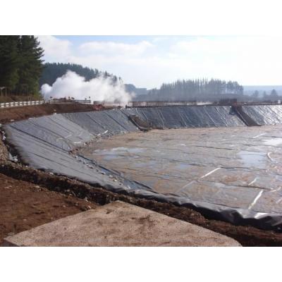
It's a landfill. They cover it with giant black tarps so garbage doesnt fly around on windy days.
El Retamo Sanitary Landfill (Resam), located at El Retamo ranch, Talca, Maule Region

Case closed Phage needs to give back the stars for the reservoir
Those are mounds of garbage in which case then they could vapor barrier the landfill and could tap into it after it matures for a source of methane
gas as a fuel source.
edit on 26-3-2012 by maestromason because: (no reason given)
its an old contaminated mining site.
we didnt do to bad though
Originally posted by intergalactic fire
Is it this you are looking for?
ciperchile.cl...
we didnt do to bad though
Ending this morning's entertainment.
Besides me having to shoot at someone about one hour ago attempting to break into my neighbor's garage...this was fun.
Goodnight everyone!
Besides me having to shoot at someone about one hour ago attempting to break into my neighbor's garage...this was fun.
Goodnight everyone!
edit on 26-3-2012 by maestromason because: (no reason given)
reply to post by Phage
No , that one is from Cabildo.
I will see if i can find something from that site. The mine is called Las Palmas.
It was a gold mine
No , that one is from Cabildo.
I will see if i can find something from that site. The mine is called Las Palmas.
It was a gold mine
I'm with Phage here - it's a plastic lined reservoir that has gone dry, the other stuff to the side is likely the water plant.
reply to post by Bedlam
No waterplant. It's an abandoned mine. It has collapsed during the 2011 feb earthquake.
the 'stuff' you see is this.
a waterproof cover or landfill
www.abovetopsecret.com...
More info on the accident
www.abovetopsecret.com...
No waterplant. It's an abandoned mine. It has collapsed during the 2011 feb earthquake.
the 'stuff' you see is this.
a waterproof cover or landfill
www.abovetopsecret.com...
More info on the accident
www.abovetopsecret.com...
reply to post by Phage
Can't seem to find any pics from the site.
If you google 'las palmas pencahue mina' you can find some info on the mine and accident.
Only in spanish though
Can't seem to find any pics from the site.
If you google 'las palmas pencahue mina' you can find some info on the mine and accident.
Only in spanish though
edit on 26-3-2012 by intergalactic fire because: (no reason given)
Originally posted by intergalactic fire
No waterplant. It's an abandoned mine. It has collapsed during the 2011 feb earthquake.
Sweet! We sometimes line small reservoirs or large ponds with the same sheeting here, especially for aquaculture like fresh water prawns, tilapia or catfish. You also see them make sewage lagoons that way.
If not a catch basin for water to irrigate nearby crops, it could be a compost pit to fertilize the crops. It being a hilly region alot of top soil
could be washed away during rains.
I guess I spoke too soon...lol I see the Earthquake marker on GE.
I guess I spoke too soon...lol I see the Earthquake marker on GE.
edit on 26-3-2012 by Boomer1941 because: addendum
dried up riverbed with blue / gray clay as bottom
thats my two cents
ah ok, i read the previous post
thats my two cents
ah ok, i read the previous post
edit on 26-3-2012 by pheniks because: (no reason given)
Looks to me like a leech pad for mining activities. Contours would help but if it were the buildings to the east would be where they processed out
the heavy metals. Northwest looks like possibly haul roads for the ore. Just a guess without more detail.
Lesott
Lesott
Originally posted by Phage
reply to post by IgnorantSpecies
I don't see "huge masses of elevation". I see some uneven shading which could be due to moisture or standing water. I believe it is an empty reservoir.
If you are seeing the darker areas as shadows you are mistaken. Look at the actual shadows cast by the trees and buildings.
edit on 3/26/2012 by Phage because: (no reason given)
Well you'd be wrong
i guess it was huge masses of elevation
reply to post by IgnorantSpecies
Very Intriguing find friend, star and flag for you. At first glance I figured perhaps it was a solar panel field but solar panels are never placed so close together, also they are usually in organized rows. Then I noticed it kind of looks like a gigantic tarp of sorts, perhaps hidng or covering an excavations site, maybe a waste dump or something else that may need to be covered for safety purposes. Whatever it is it isn't natural, as you pointed out the elevation differences clearly give that away. However when I focused in two more notches I noticed something even more odd. If you zoom in more you'll notice that it has many cracks and creases similar to that of human skin! Nonetheless it could very well be cracks and creases in the tarp. It could very well be some sort of waste dump and the complexes next to it could be processing facilities. It's definately strange though, there are a hundred different things it could be but not really a way to know for sure. Definately odd how it is near the epicenter of the earthquake, that raises a few flags.
Very Intriguing find friend, star and flag for you. At first glance I figured perhaps it was a solar panel field but solar panels are never placed so close together, also they are usually in organized rows. Then I noticed it kind of looks like a gigantic tarp of sorts, perhaps hidng or covering an excavations site, maybe a waste dump or something else that may need to be covered for safety purposes. Whatever it is it isn't natural, as you pointed out the elevation differences clearly give that away. However when I focused in two more notches I noticed something even more odd. If you zoom in more you'll notice that it has many cracks and creases similar to that of human skin! Nonetheless it could very well be cracks and creases in the tarp. It could very well be some sort of waste dump and the complexes next to it could be processing facilities. It's definately strange though, there are a hundred different things it could be but not really a way to know for sure. Definately odd how it is near the epicenter of the earthquake, that raises a few flags.
reply to post by IgnorantSpecies
Chile is one of the largest producers of wine in the world . I am pretty much sure that what your original image shows is a protective covering of a young vineyard . These can remain in place for anything up to 15 years
Chile is one of the largest producers of wine in the world . I am pretty much sure that what your original image shows is a protective covering of a young vineyard . These can remain in place for anything up to 15 years
new topics
-
Mike Pinder The Moody Blues R.I.P.
Music: 43 minutes ago -
Putin, Russia and the Great Architects of the Universe
ATS Skunk Works: 3 hours ago -
A Warning to America: 25 Ways the US is Being Destroyed
New World Order: 8 hours ago
top topics
-
President BIDEN's FBI Raided Donald Trump's Florida Home for OBAMA-NORTH KOREA Documents.
Political Conspiracies: 13 hours ago, 31 flags -
A Warning to America: 25 Ways the US is Being Destroyed
New World Order: 8 hours ago, 13 flags -
Is AI Better Than the Hollywood Elite?
Movies: 15 hours ago, 4 flags -
Mike Pinder The Moody Blues R.I.P.
Music: 43 minutes ago, 2 flags -
Maestro Benedetto
Literature: 15 hours ago, 1 flags -
Putin, Russia and the Great Architects of the Universe
ATS Skunk Works: 3 hours ago, 1 flags
active topics
-
Gaza Terrorists Attack US Humanitarian Pier During Construction
Middle East Issues • 59 • : CarlLaFong -
Meadows, Giuliani Among 11 Indicted in Arizona in Latest 2020 Election Subversion Case
Mainstream News • 16 • : Threadbarer -
Democrats Introduce Bill That Will Take Away Donald Trumps Secret Service Protection
2024 Elections • 75 • : TzarChasm -
Alternate Electors vs Fake Electors - What is the Difference.
2024 Elections • 121 • : frogs453 -
New whistleblower Jason Sands speaks on Twitter Spaces last night.
Aliens and UFOs • 68 • : baablacksheep1 -
Putin, Russia and the Great Architects of the Universe
ATS Skunk Works • 14 • : RussianTroll -
Truth Social goes public, be careful not to lose your money
Mainstream News • 132 • : matafuchs -
Mike Pinder The Moody Blues R.I.P.
Music • 1 • : RussianTroll -
Mood Music Part VI
Music • 3106 • : TheWoker -
University of Texas Instantly Shuts Down Anti Israel Protests
Education and Media • 275 • : Vermilion