It looks like you're using an Ad Blocker.
Please white-list or disable AboveTopSecret.com in your ad-blocking tool.
Thank you.
Some features of ATS will be disabled while you continue to use an ad-blocker.

West Coast USA: Pay Attention, Cascadia May Be Ready to Rupture
page: 16share:
Is it just me... or does everything (including the whole ring of fire) seem wayyyy to quiet today?
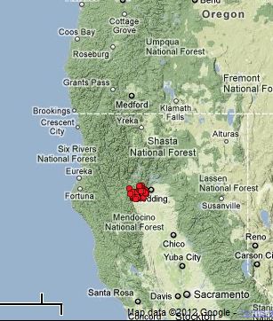
Its way too early but it looks like a swarm starting. Last three days. If so, its not only early, its 50 miles south of where the swarms usually
occur
reply to post by zworld
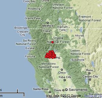
This little Mag 2.7 shook just NW of your 3-day ETS cluster.
This little Mag 2.7 shook just NW of your 3-day ETS cluster.
Magnitude
2.7
Date-Time
Sunday, February 19, 2012 at 15:56:33 UTC
Sunday, February 19, 2012 at 07:56:33 AM at epicenter
Location
41.092°N, 123.138°W
Depth
39.9 km (24.8 miles)
Region
NORTHERN CALIFORNIA
Distances
42 km (26 miles) SE (138°) from Somes Bar, CA
43 km (27 miles) NNW (337°) from Weaverville, CA
45 km (28 miles) SSW (206°) from Etna, CA
58 km (36 miles) N (1°) from Hayfork, CA
82 km (51 miles) SSW (211°) from Yreka, CA
316 km (196 miles) NNW (334°) from Sacramento, CA
Location Uncertainty
horizontal +/- 1.9 km (1.2 miles); depth +/- 1.3 km (0.8 miles)
Parameters
Nph= 14, Dmin=33 km, Rmss=0.28 sec, Gp=194°,
M-type=duration magnitude (Md), Version=0
Source
California Integrated Seismic Net:
USGSCaltechCGSUCBUCSDUNR
Event ID
nc71738376
This is most probably coincidence, but in case there is some sort of correlation, here it is.
The spectrogram at Arnica Sink (Station LAS--located in the middle of the Medicine Lake crater, northern CA) showed this small "bump" in spectra beginning about 2 hours ago.
 Source
The last time I saw this was on Feb 4th, 3 hours before the Mag 3.0 offshore Oregon @ 19:08UTC, followed over the next hour by the Mag4.3 off Oregon's coast, and the Mag 5.6 & Mag 4.8 off Vancouver Island.

Here is a link for Arnica Sink past 16 days.
I have no idea if this indicates more to come along the PNW in next few hours, but since this small Mag 2.7 happened, I thought I would share what I've noticed.
ETA: Here is a Link to the spectro for TA.N02D..BHZ, which is located halfway between the center of the ETS cluster and the Mag 2.7 from 15:56UTC in the Trinity Alps. It's pretty noisy.
The spectrogram at Arnica Sink (Station LAS--located in the middle of the Medicine Lake crater, northern CA) showed this small "bump" in spectra beginning about 2 hours ago.
 Source
 The last time I saw this was on Feb 4th, 3 hours before the Mag 3.0 offshore Oregon @ 19:08UTC, followed over the next hour by the Mag4.3 off Oregon's coast, and the Mag 5.6 & Mag 4.8 off Vancouver Island.

Here is a link for Arnica Sink past 16 days.
I have no idea if this indicates more to come along the PNW in next few hours, but since this small Mag 2.7 happened, I thought I would share what I've noticed.
ETA: Here is a Link to the spectro for TA.N02D..BHZ, which is located halfway between the center of the ETS cluster and the Mag 2.7 from 15:56UTC in the Trinity Alps. It's pretty noisy.
edit on 2/19/2012 by
Olivine because: add link
edit on 2/19/2012 by Olivine because: fix too tiny thumbnail
reply to post by Olivine
I was debating with myself on posting about this, but your post tipped the scales.
In this post on page 47 of Quakewatch 2012 I make mention of a quake that took place on Feb 9, 2012 which is near the antipodal point of the CSZ.
Today, we have this quake:
USGS
As already noted by Hellas in Quakewatch 2012 in the same location.
Now, this probably means nothing but in light of our post I thought I would post this here in case something does happen, there would be a record of the occurrence.
PM, if your lurking around here, I haven't found the time to go through the data yet as you suggested in your response to my antipodes post referenced above, but I am certainly intrigued by what such a seach would produce.
I was debating with myself on posting about this, but your post tipped the scales.
In this post on page 47 of Quakewatch 2012 I make mention of a quake that took place on Feb 9, 2012 which is near the antipodal point of the CSZ.
Today, we have this quake:
Magnitude 5.0
Date-Time Sunday, February 19, 2012 at 15:17:29 UTC Sunday,February19,2012at 06:17:29PM at epicenter Time of Earthquakein otherTimeZones
Location 40.997°S, 44.565°E
Depth 15.3 km (9.5 miles)
Region SOUTHWEST INDIANRIDGE
724 km (449 miles) NW of Ile aux Cochons, Crozet Islands
Distances
843 km (523 miles) NE of Marion Island, Prince Edward Islands 1741 km (1081 miles) SE of Durban, South Africa 2003 km (1244 miles) SSE of MAPUTO, Mozambique
Location Uncertainty horizontal+/- 18.7 km (11.6 miles);depth +/- 4.8km (3.0miles)
Parameters NST=145, Nph=163, Dmin=843.8 km, Rmss=0.63 sec, Gp= 43°, M-type=body wave magnitude (Mb), Version=5
Source Magnitude: USGSNEIC (WDCS-D) Location: USGSNEIC (WDCS-D)
Event ID usb00082gb
USGS
As already noted by Hellas in Quakewatch 2012 in the same location.
Now, this probably means nothing but in light of our post I thought I would post this here in case something does happen, there would be a record of the occurrence.
PM, if your lurking around here, I haven't found the time to go through the data yet as you suggested in your response to my antipodes post referenced above, but I am certainly intrigued by what such a seach would produce.
edit on 19-2-2012 by jadedANDcynical because: nickfix
reply to post by jadedANDcynical
Oli and J&C. We missed a quake. There was a 3.1 two + days ago. It's all in a linear flow that is slitghtly curved emanating fan like from the MTJ exactly like so many other series in this size group through the years.
I wish we had been mapping these years ago and tried to establish a data base we could be referring to. Oh well, we are starting one now.
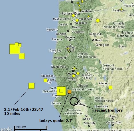
Just went to the USGS and the map showed
a very large ring of small earthquakes
encircling what I would think is the magma chamber
of Yellowstone's Super Volcano. Didn't recent
geological surveys come up with the idea that
the magma chamber covers the corner areas
of 3 or 4 surrounding states ?
earthquake.usgs.gov...
a very large ring of small earthquakes
encircling what I would think is the magma chamber
of Yellowstone's Super Volcano. Didn't recent
geological surveys come up with the idea that
the magma chamber covers the corner areas
of 3 or 4 surrounding states ?
earthquake.usgs.gov...
reply to post by TrueAmerican
Does anyone know if the cascadia fault could trigger the yellowstone super volcano, or vive versa?
Does anyone know if the cascadia fault could trigger the yellowstone super volcano, or vive versa?
has anyone posted or mentioned these pics or know their source or validity, i found them online a couple of years ago.
There are also youtube vids but i dont wanna scare people... Lol
second pic i found after looking further into the validity
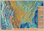
first source i found or a friend gave me or something

There are also youtube vids but i dont wanna scare people... Lol
second pic i found after looking further into the validity
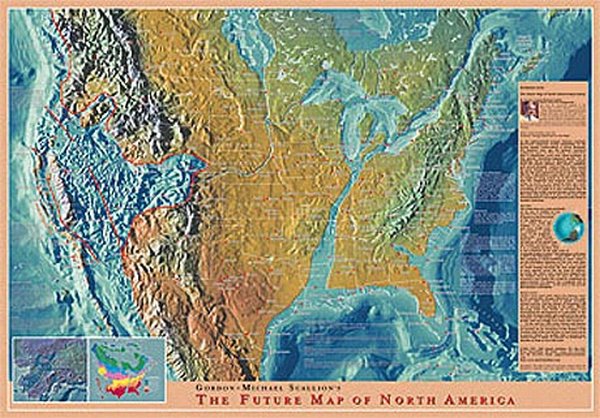
first source i found or a friend gave me or something
Dont know what everyone thinks of this, but I thought it may be a good idea to have a more natural view of earthquakes rather than spots on maps
indicating depths. The top line is the surface earth and depth goes downwards. West and South is on the left.
I have plotted depth against latitude and depth agains longitude and this is the result. Not guaranteeing that it is correct but I have given it the once-over and seems to be more or less right. Let me know if you find any anomalies. The best way to look at these is to open them in two browser tabs and then switch back and forth between them.
Data from USGS downloaded from the M1+ 7-day text file.
Please let me know what you all think and if there are other charts I can have a go at producing. My USGS data goes back to Jan 2009.
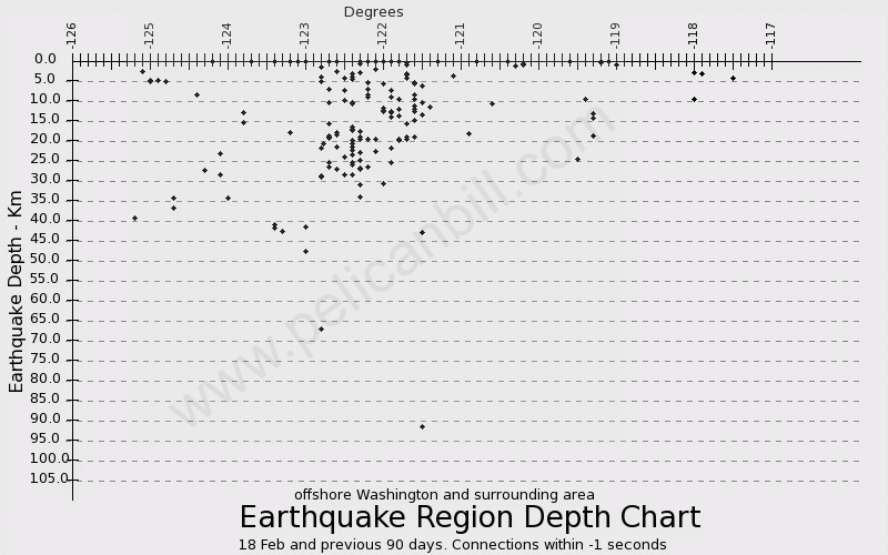
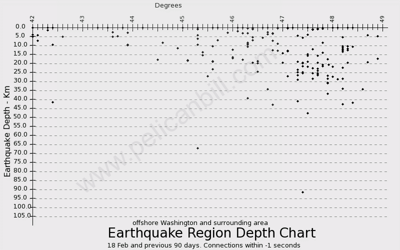
The data on which these charts are based is here
================================
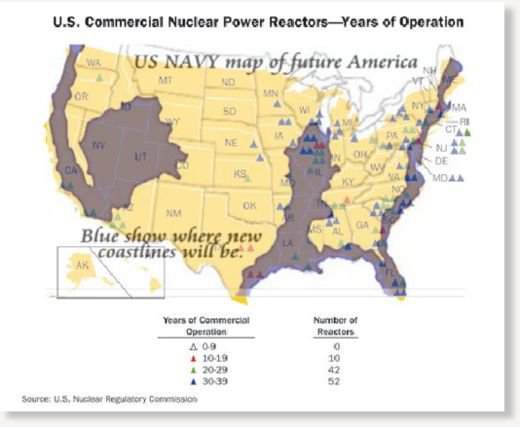
n3v3rmor3 - I should think the source of your second pic is likely to be the NRC page here plus something like a map of the height above sea level. They might well have the actual image you posted in some other part of their site. The title is the same anyway.
I have plotted depth against latitude and depth agains longitude and this is the result. Not guaranteeing that it is correct but I have given it the once-over and seems to be more or less right. Let me know if you find any anomalies. The best way to look at these is to open them in two browser tabs and then switch back and forth between them.
Data from USGS downloaded from the M1+ 7-day text file.
Please let me know what you all think and if there are other charts I can have a go at producing. My USGS data goes back to Jan 2009.
The data on which these charts are based is here
================================
n3v3rmor3 - I should think the source of your second pic is likely to be the NRC page here plus something like a map of the height above sea level. They might well have the actual image you posted in some other part of their site. The title is the same anyway.
edit on 19 Feb 2012 by qmantoo because: NRC link
reply to post by qmantoo
Nice charts, but I hate to be the bearer of bad news. For anything over some tens of kilometers out at sea off the west coast, depths are extremely difficult to gauge, and they are most likely not accurate. For some quakes this could change in the future, as Ocean Bottom Seismometer (OBS) data becomes available. Some quakes may be relocated and depths reassessed. But there is no guarantee of this. Inside sources have informed me that no decision has been made yet, as far as they are aware, of what, if anything, will be done with OBS data relative to already listed events.
Obviously it would be a tremendous job to re qualify all events recorded since the OBS's went in. They may have neither the manpower or funding to accomplish this. If I had to guess, someone might start taking a look at the bigger events first. Or they may not at all. I don't know.
For those that may not understand what in the heck I am talking about- due to the fact that prior to OBS, most or all stations have been on land. This presents a difficult problem when you only have seismic data from one side of a quake. And evidently so, as we just witnessed a couple of major epicenter re locations- to nearly 200 km from their original plotted locations. OBS data could change both depths and epicenters, and maybe even ML magnitudes of certain events off the coast. But the bottom line is depth and epicenter locations are very unreliable off the west coast, especially for the smaller events.
And to nearly quote verbatim an inside source- "There is a lot of seismicity happening out there that we cannot detect at all from land."
Ok, so I need to try to understand what you are saying. I think you are saying that any data about earthquakes which happen at sea (not near the
coast) is unreliable due to not having seismic measuring buoys or seabed measuring devices? When these devices come online, measurements will be much
more accurate.
HOW much more accurate will they be, and HOW in-accurate are they now?
Correct me if I am wrong, but there have been many many earthquakes which happen at sea and are you saying that the details which USGS are publishing (and have been for years) are unreliable and the events could be at least hundreds of kilometers different from where they are reported to be? Where is the official notice to all the universities and earth scientists who are using this data as a basis for their published papers? No-one would accept that it was as unreliable as what you are suggesting.
I am afraid after all that, I dont understand what you are saying and it makes no sense to me - even after your explanation above. :-)
Originally posted by qmantoo
HOW much more accurate will they be, and HOW in-accurate are they now?
Once OBS data is available, it will provide a means to further qualify quake events in magnitude, depth and location. To what degree exactly I do not know. But just better, making earthquake reports using such data, in addition to land stations, more accurate.
Also, we just had another 3.4 off the coast of Oregon, and it appears to be an aftershock of the 6.0:
earthquake.usgs.gov...
So is USGS data accurate or not? Without knowing how in-accurate it is, we have to assume that it is as accurate as instruments will currently allow.
This is why I dont understand your previous comment about being the bringer of bad news. I dont really mind one way or the other since I have ceased
to be as interested in eqs as I once was, but it would be nice to be able to think that these charts were useful in "visualising the ground beneath
our feet" and where eq events happened. More useful than blobs on a map to depict depth anyway.
Originally posted by TrueAmerican
Also, we just had another 3.4 off the coast of Oregon, and it appears to be an aftershock of the 6.0:
earthquake.usgs.gov...
Originally posted by qmantoo
So is USGS data accurate or not? Without knowing how in-accurate it is, we have to assume that it is as accurate as instruments will currently allow. This is why I dont understand your previous comment about being the bringer of bad news. I dont really mind one way or the other since I have ceased to be as interested in eqs as I once was, but it would be nice to be able to think that these charts were useful in "visualising the ground beneath our feet" and where eq events happened. More useful than blobs on a map to depict depth anyway.
There is definately something to learn from understanding the depth charts. This became evident to me with the series of two quakes (6 and 5.9) in the exact same spot one second apart near the most recent EQ. I have always thought this impossible, as the plate is either in motion or it's not. How it could be in motion one second then stop then be in motion the next is still going way over my head.
So depth has taken on new importance to me. And I suspected that PNSN wasnt mapping the depth of these two properly, and one was deeper than the other. But I wasnt aware though that even inside the USGS they believe there are EQs out there that they dont even map. Sure would be nice if USGS clarified that position.
ON EDIT: Or PNSN isnt mapping the location accurately. Now hearing TA I realize it could be either. And i hope it is one or the other or both, because in my world you still cant have two simultaneous quakes in the exact same location.
edit on 20-2-2012 by zworld because: (no reason
given)
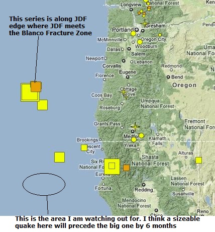
reply to post by zworld
"This is the area I am watching out for"
So it appears you are pointing to the left edge of the Gorda Plate, is that right? And I'm curious, why do you believe a precursor quake would strike there, six MONTHS out from a catastrophic rupture of the CSZ?
"This is the area I am watching out for"
So it appears you are pointing to the left edge of the Gorda Plate, is that right? And I'm curious, why do you believe a precursor quake would strike there, six MONTHS out from a catastrophic rupture of the CSZ?
Originally posted by zworld
ON EDIT: Or PNSN isnt mapping the location accurately. Now hearing TA I realize it could be either. And i hope it is one or the other or both, because in my world you still cant have two simultaneous quakes in the exact same location.edit on 20-2-2012 by zworld because: (no reason given)
The statements I have made come from a basis of inside information. They are not about to tell you that quake depths are inaccurate, and neither am I.
They are doing their damn level best with what they have to work with.
As to the two quakes 1 second apart, I didn't have too much trouble understanding how this could happen. On a diversionary boundary like that, one side could move away, and the other side could immediately move to fill in the gap. Thus, two quakes, back to back.
The USGS seems to be the site that is watched the most. What about this site. They have information that is so different at times. Is the anf a bogus
site?
edit on 20-2-2012 by AuntB because: Edited link
Originally posted by TrueAmerican
Originally posted by zworld
ON EDIT: Or PNSN isnt mapping the location accurately. Now hearing TA I realize it could be either. And i hope it is one or the other or both, because in my world you still cant have two simultaneous quakes in the exact same location.edit on 20-2-2012 by zworld because: (no reason given)
The statements I have made come from a basis of inside information. They are not about to tell you that quake depths are inaccurate, and neither am I.
They are doing their damn level best with what they have to work with.
As to the two quakes 1 second apart, I didn't have too much trouble understanding how this could happen. On a diversionary boundary like that, one side could move away, and the other side could immediately move to fill in the gap. Thus, two quakes, back to back.
Ah yes. Excellent. I can see that now. But they wouldnt be in the exact same spot, just far enough apart that the sensors couldnt really identify the difference.
new topics
-
A Warning to America: 25 Ways the US is Being Destroyed
New World Order: 10 minutes ago -
America's Greatest Ally
General Chit Chat: 55 minutes ago -
President BIDEN's FBI Raided Donald Trump's Florida Home for OBAMA-NORTH KOREA Documents.
Political Conspiracies: 5 hours ago -
Maestro Benedetto
Literature: 7 hours ago -
Is AI Better Than the Hollywood Elite?
Movies: 7 hours ago -
Las Vegas UFO Spotting Teen Traumatized by Demon Creature in Backyard
Aliens and UFOs: 11 hours ago -
2024 Pigeon Forge Rod Run - On the Strip (Video made for you)
Automotive Discussion: 11 hours ago
top topics
-
President BIDEN's FBI Raided Donald Trump's Florida Home for OBAMA-NORTH KOREA Documents.
Political Conspiracies: 5 hours ago, 26 flags -
Krystalnacht on today's most elite Universities?
Social Issues and Civil Unrest: 17 hours ago, 9 flags -
Gaza Terrorists Attack US Humanitarian Pier During Construction
Middle East Issues: 12 hours ago, 8 flags -
Supreme Court Oral Arguments 4.25.2024 - Are PRESIDENTS IMMUNE From Later Being Prosecuted.
Above Politics: 17 hours ago, 8 flags -
Weinstein's conviction overturned
Mainstream News: 15 hours ago, 8 flags -
Massachusetts Drag Queen Leads Young Kids in Free Palestine Chant
Social Issues and Civil Unrest: 14 hours ago, 7 flags -
Las Vegas UFO Spotting Teen Traumatized by Demon Creature in Backyard
Aliens and UFOs: 11 hours ago, 6 flags -
Meadows, Giuliani Among 11 Indicted in Arizona in Latest 2020 Election Subversion Case
Mainstream News: 14 hours ago, 5 flags -
2024 Pigeon Forge Rod Run - On the Strip (Video made for you)
Automotive Discussion: 11 hours ago, 4 flags -
Is AI Better Than the Hollywood Elite?
Movies: 7 hours ago, 3 flags
active topics
-
Massachusetts Drag Queen Leads Young Kids in Free Palestine Chant
Social Issues and Civil Unrest • 15 • : tarantulabite1 -
A Warning to America: 25 Ways the US is Being Destroyed
New World Order • 0 • : charlest2 -
America's Greatest Ally
General Chit Chat • 1 • : BingoMcGoof -
How ageing is" immune deficiency"
Medical Issues & Conspiracies • 35 • : annonentity -
HORRIBLE !! Russian Soldier Drinking Own Urine To Survive In Battle
World War Three • 49 • : Freeborn -
Gaza Terrorists Attack US Humanitarian Pier During Construction
Middle East Issues • 30 • : Asher47 -
Electrical tricks for saving money
Education and Media • 8 • : anned1 -
Is AI Better Than the Hollywood Elite?
Movies • 16 • : 5thHead -
Hate makes for strange bedfellows
US Political Madness • 48 • : Terpene -
President BIDEN's FBI Raided Donald Trump's Florida Home for OBAMA-NORTH KOREA Documents.
Political Conspiracies • 17 • : BingoMcGoof