It looks like you're using an Ad Blocker.
Please white-list or disable AboveTopSecret.com in your ad-blocking tool.
Thank you.
Some features of ATS will be disabled while you continue to use an ad-blocker.

West Coast USA: Pay Attention, Cascadia May Be Ready to Rupture
page: 19share:
Originally posted by zworld
reply to post by TrueAmerican
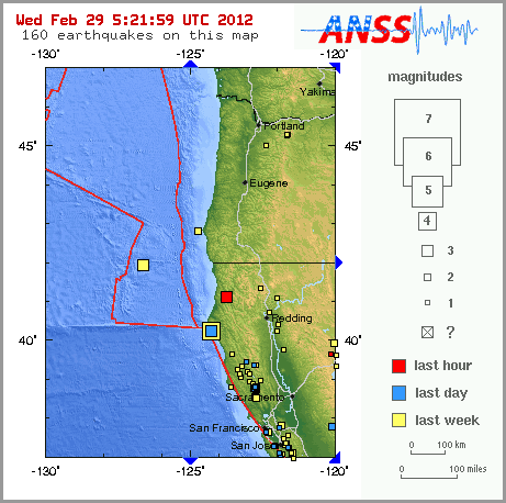
not only in the zone, when looking on the historic map, (even though I think it only goes down to >3 or 4), that area is totally void of EQs if memory serves.
And thats right on the Gorda/JDF line. I think its safe to say that that is smack dab in the heart of the locked point where I was surmising the pressure from EQs far offshore southwest Gorda would push into and cause the CSZ to rupture north from there.
Area to watch definitely
I have been following and trying to learn about EQ's for a year now without any advancement really.
Too bad there is not a dummy class ..its just too in depth.
How do you know its a "locked point"??
Originally posted by MamaJ
How do you know its a "locked point"??
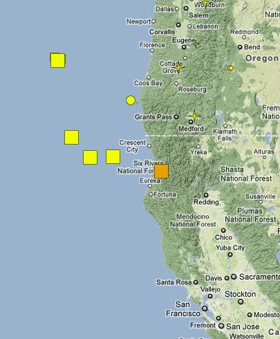
I love visuals. This is one of the better ones for understanding the three zones. The locked zone is where the two plates first meet and then that extends back till it transitions into a more released state ie the transition zone.
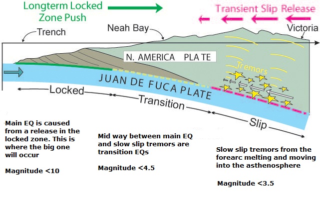
I guess locked zones release the biggest EQs but thats about all I know of locked zones.
ON EDIT. hit reply to fast.
And the reason I think that there is a particularly intense locked point right there is because thats where JDF and Gorda are splitting apart.
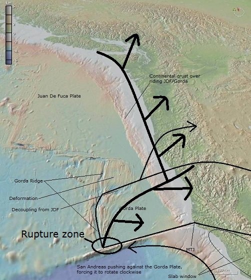
I should add that thats my guess at how the CSZ will go. Its just a guess....but I think that the southwest tip of Gorda thats being pushed up by the San Andreas/Pacific plate and is circled is where the first series of large pre quakes will take place. This will push pressure into the locked point actually just about where the little quake was today. And then from here the Gorda and JDF tear apart, and the mega quakes hit moving up the coast as it ruptures
edit on 26-2-2012 by zworld because: (no reason given)
Originally posted by TrueAmerican
Oh, what's this?
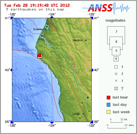
A new 2.7 close to shore off Oregon, on the upper lip of subduction.
earthquake.usgs.gov...
Yeah...right....
Nope, can't speculate on that one, even if it has been reviewed, which it has.

Yeah yeah. I know. That's unfair. Sorry Steve. Sorry John. Just frustration at not being able to depend on those locations for speculation. I can only imagine how frustrating to you all it must be. OBS, baby!
Magnitude
3.0
Date-Time
Tuesday, February 28, 2012 at 19:17:34 UTC
Tuesday, February 28, 2012 at 11:17:34 AM at epicenter
Time of Earthquake in other Time Zones
Location
40.286°N, 124.318°W
Depth
19.9 km (12.4 miles)
Region
NORTHERN CALIFORNIA
Distances
5 km (3 miles) SSW (213°) from Petrolia, CA
30 km (18 miles) SW (217°) from Rio Dell, CA
33 km (20 miles) S (188°) from Ferndale, CA
58 km (36 miles) SSW (193°) from Eureka, CA
311 km (193 miles) NW (309°) from Sacramento, CA
Location Uncertainty
horizontal +/- 1.2 km (0.7 miles); depth +/- 0.7 km (0.4 miles)
Parameters
Nph= 14, Dmin=4 km, Rmss=0.16 sec, Gp=187°,
M-type=local magnitude (ML), Version=3
Source
California Integrated Seismic Net:
USGS Caltech CGS UCB UCSD UNR
Event ID
nc71743666
earthquake.usgs.gov...
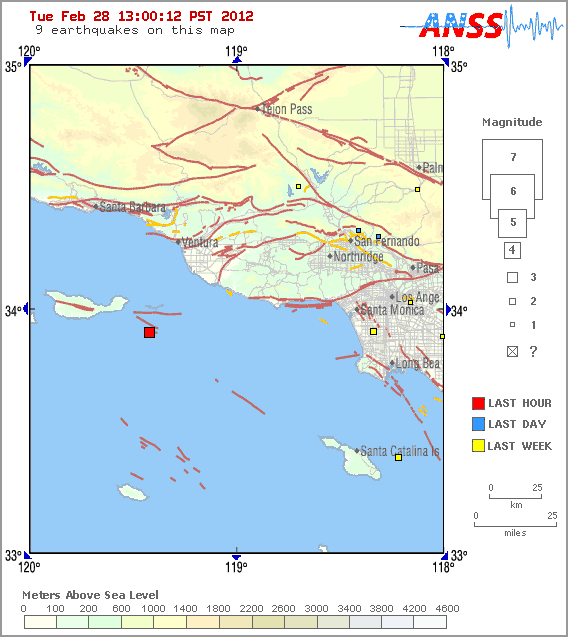
Magnitude
3.5
Date-Time
Tuesday, February 28, 2012 at 20:15:32 UTC
Tuesday, February 28, 2012 at 12:15:32 PM at epicenter
Time of Earthquake in other Time Zones
Location
33.904°N, 119.419°W
Depth
8.6 km (5.3 miles)
Region
CHANNEL ISLANDS REGION, CALIFORNIA
Distances
34 km (21 miles) SSW (213°) from Channel Islands Beach, CA
35 km (22 miles) SW (216°) from Port Hueneme, CA
39 km (24 miles) SW (214°) from Oxnard, CA
109 km (68 miles) W (262°) from Los Angeles Civic Center, CA
Location Uncertainty
horizontal +/- 0.5 km (0.3 miles); depth +/- 3.2 km (2.0 miles)
Parameters
Nph= 55, Dmin=22 km, Rmss=0.51 sec, Gp= 90°,
M-type=local magnitude (ML), Version=1
Source
California Integrated Seismic Net:
USGS Caltech CGS UCB UCSD UNR
Event ID
ci15115849
earthquake.usgs.gov...
edit on 28-2-2012 by berkeleygal because: (no reason given)
3.5 2012/02/28 12:15:32 33.896N 119.424W 12.1 35 KM (21 MI) SSW OF CHANNEL ISLANDS BEACH, CA
3.0 2012/02/28 11:17:34 40.286N 124.318W 19.9 5 KM ( 3 MI) SSW OF PETROLIA, CA
bump
Where is everyone? seems to be getting bigger
Magnitude
3.7
Date-Time
Wednesday, February 29, 2012 at 05:00:33 UTC
Tuesday, February 28, 2012 at 09:00:33 PM at epicenter
Location
41.141°N, 123.795°W
Depth
30.6 km (19.0 miles)
Region
NORTHERN CALIFORNIA
Distances
9 km (6 miles) SW (235°) from Weitchpec, CA
28 km (17 miles) NNW (342°) from Willow Creek, CA
29 km (18 miles) ENE (67°) from Westhaven-Moonstone, CA
50 km (31 miles) NE (38°) from Eureka, CA
349 km (217 miles) NW (326°) from Sacramento, CA
Location Uncertainty
horizontal +/- 0.4 km (0.2 miles); depth +/- 1.4 km (0.9 miles)
Parameters
Nph= 29, Dmin=19 km, Rmss=0.13 sec, Gp= 72°,
M-type=regional moment magnitude (Mw), Version=5
Source
California Integrated Seismic Net:
USGS Caltech CGS UCB UCSD UNR
Event ID
nc71743876
Originally posted by berkeleygal
Where is everyone? seems to be getting bigger
Gorda's waking up.
Note that PNSN has moved the earlier onshore quake in the same spot now out to sea, which they seem to do alot.
The line now reflects the southern edge of Gorda as it grinds against the San Andreas.
Originally posted by zworld
Note that PNSN has moved the earlier onshore quake in the same spot now out to sea, which they seem to do alot.
Which is why there is no point in speculating for those quakes any more. We can't depend on them.
Once there is a station on the west side of quake though, those are probably reasonably good.
TrueAmerican
Which is why there is no point in speculating for those quakes any more. We can't depend on them.
Once there is a station on the west side of quake though, those are probably reasonably good.
You never did answer my question about the USGS earthquakes and why you feel that the data is not reliable, but you keep on saying that OBS is the answer to everything. What we have is perfectly good for the government agencies to base their predictions and forcasts on and why do scientists cite all this data in their papers if it is generally as unreliable as you keep saying?
Basically, you cannot have it both ways - either it is totally unreliable within a radius of 200 miles of a coastline or else you have to admit that it is reliable (but of course OBS will make it more reliable due to better instruments and more of them).
As I said before, I dont understand why you think the earthquake data we have at present is unreliable.
TrueAmerican
Thank you for your private message reply.
I have read the thread - every page and every post. I know the thread was speculating on the small quakes just off shore. However as I said, you have not answered my question about the reliability of the data.
This is an important issue and has everything to do with what was discussed on the thread - because you said that the data was not reliable and THEN you said it was reliable. Is it or isn't it?
I am trying to pin you down to one side of the fence or the other since it is so important to not only us here on the thread but also others using the data supplied by all of the earthquake/tremor measuring agencies.
Originally posted by qmantoo
TrueAmerican
Thank you for your private message reply.
I have read the thread - every page and every post. I know the thread was speculating on the small quakes just off shore. However as I said, you have not answered my question about the reliability of the data.
Wow, you just don't give up, do you. Kinda like me. You know, I like that!
Your graphs are plots of ESTIMATED hypocenter depths. But they are the best estimates we have. In some cases they are going to be off somewhat. And in others they are going to be off by a LOT. I have merely pointed out that where they are more likely to be off is for those quakes farther out to sea, and of smaller magnitudes. The s-waves of the smaller ones are tougher to spot, so they have to review them more carefully, so they can define P-S ratios and come up with a distance to the land station.
There's not a single measure of an earthquake event, that is 100% accurate. They are best estimates, supported by a backing of collaborative sciences, and to varying degrees, supported as well by consensus and experience. And so what I am trying to tell you is that you are asking a question that is truly impossible to answer. Unless of course you'd care to invent a way you can stick your head down into the earth and tell us what's going on!
How reliable is the data on your charts? As reliable as it can be given the circumstances. And the more you understand the circumstances of what seismologists do, and especially in that bad spot, the better the understanding you will have of which of those depths plotted are going to be the more accurate ones. Ones out at sea? Less accurate than those constrained over land. So look back at your plots, and basically all the ones on the left of the first plot are not going to be as accurate, in depth, hypocenter, and epicenter, as the ones on the right. And the reason for that is the ones off shore are only measured from the right side, if you see what I am saying.
When you put this in the context of seismic institutions and universities, which you have, and then try to use that as a point to still not understand my explanations- keep in mind that seismologists at these places are of course aware of this problem and yet still do the best they can with what they have to give the best figure they can under the circumstances.
A depth plot of earthquakes off the coast of Oregon and California should immediately therefore key those cautions in the people that know these things. That's why I was the bearer of bad news in your case. Because part of the data is indeed unreliable, and in the case of depths out at sea, particularly so. Yeah, the OBS data could make a helpful difference, so that the next time we look at your plots, all those off shore depths would be more accurate.
Ha. And I am talking about offshore quakes! As if there were some kind of sureness of the depths under land! Have you looked at the uncertainty errors for each of those quakes you have plotted? We are talking about KILOMETERS of uncertainty in depth, and in epicenter, even for those!
So now go back and look at your plots. And tell me what it really means. Any one of those dots represents only an estimated location that is really, pretty far off. Yup, welcome to hell.
edit on Fri Mar 2nd 2012 by TrueAmerican because: (no reason given)
OK, thanks. I understand now more about the problem. The thing I remember from my school days is that where there are larger uncertainties then the
figures would probably be rounded round to the nearest whole number or power of 10 or whatever - depending on the level of uncedertainty. However,
some of the depth figures are to one decimal place which suggests that they are accurate to within 1 kilometre or so. Otherwise they would only give
integer kilometre depths.
The thing is, we are talking about figures supplied by (earth) scientists and they know these restrictions so they would not knowingly give loose figures to one decimal place it there was no hope of achieving that level of accuracy.
So although I understand your explanation, it still does not make good science to give an accuracy that the scientists know is wrong.
About the charts, they are probably as accurate as the USGS figures allow and as accurate as their charts and maps - since it uses the same figures as they are using.
reply to post by zworld
Thank you so much for the visuals....NOW, I understand what you were referring to. Hopefully things will not get worse but I like many others think it is just a matter of time. Literally.
Off topic: I live in TN...we are supposed to have tornadoes today. School is even letting out 3 hours early due to the threat. Even if you or the other posters are not the praying kind...say a little one for us. UGH! I hate severe storms.
With the smaller quakes off shore Oregon, I believe what may be happening is that USGS auto locating algorithms are having trouble picking up on
s-wave components to locate the quake at first, so that when they are first listed at the USGS site, they are much farther off than normal. So when
the PNSN or whoever comes back around and reviews further, that's why they are having to move them so far from the auto located position and depth-
because when they actually spot the faint s-wave component and recalculate the P-S ratio, they end up far off shore instead of close.
And sometimes they may have to move the epicenter and/or depth (or any other parameter) again, after further review before they finally settle on the spot that best fits all the parameters after full review.
Or at least that's the way I understand it so far from what little feedback I have heard on the issue. It's understandable error in the way the information is delivered, and understandable more because of the particular location, and difficulty of locating quakes there. They are just tough quakes that take a while to decipher. And even after all that, they can still be off.
In contrast, Japan has had OBS data for quite a while, to constrain and process their quakes off shore. Incoming p-waves from their OBS's are also used to trigger their early warning system- which in turn triggers automated shutdowns of many systems- from trains to nuclear power reactors, to automated earthquake early warning systems, and all kinds of stuff.
If I understand things right, a key difference between the OBS systems that have been deployed off the west coast USA and those in Japan, is that theirs provide real time data streams- while the ones here don't. They have to be retrieved manually and then the data extracted.
Another thing I am coming to understand is that there are some much deeper issues going on with our monitoring systems, and it appears that some things seem to be shuffling around a bit, or even failing in certain places. In a general sense, there appear to be some problems with funding. And its effects are being felt hard in the seismology industry as a whole, just like everywhere else. These are just my perceptions and speculation from the outside. But it is based in fact.
I know that's pretty vague. But it's just going to have to do for now.
4.1 west of Vancouver Island. 6:45 AM (Pacific Time)
earthquake.usgs.gov...
(I live on the northern tip of Vancouver Island)
Pretty small quake, but I always keep my eye on that spot because many of the quakes we have seem to be around that spot.
earthquake.usgs.gov...
(I live on the northern tip of Vancouver Island)
Pretty small quake, but I always keep my eye on that spot because many of the quakes we have seem to be around that spot.
edit on 3-3-2012 by
phoenixlights321 because: (no reason given)
For those who want some technical details about why earthquake locations don't always agree between regional and national earthquake catalogs, here
is a discussion on the Pacific Northwest Seismic
Network blog.
For some details about why offshore earthquakes are hard to locate, there was a discussion on the PNSN Facebook group, Friday, 3/2 at 11:36 here.
For some details about why offshore earthquakes are hard to locate, there was a discussion on the PNSN Facebook group, Friday, 3/2 at 11:36 here.
Well!
I see we have a pro in our midst!
On behalf of all those that haven't realized it yet, I'd like to welcome you John to ATS. So where's Steve? And be sure to invite Paul too. And be sure that when you do, you tell them that they are now on terrorist watch lists, just from joining ATS. Nice, isn't it? That's right, people that talk about earthquakes and volcanoes are terrorists too. I seriously hope you don't further get yourselves all into trouble by being tempted in a weak moment to respond to some posts you may see on this site. I would advise caution.
With no more buffer zone, and direct open line to you, information can be vetted much more quickly. So in a way it's good. Enjoy your stay.
We are speculative creatures, so be forewarned.
new topics
-
A Warning to America: 25 Ways the US is Being Destroyed
New World Order: 3 hours ago -
President BIDEN's FBI Raided Donald Trump's Florida Home for OBAMA-NORTH KOREA Documents.
Political Conspiracies: 9 hours ago -
Maestro Benedetto
Literature: 11 hours ago -
Is AI Better Than the Hollywood Elite?
Movies: 11 hours ago
top topics
-
President BIDEN's FBI Raided Donald Trump's Florida Home for OBAMA-NORTH KOREA Documents.
Political Conspiracies: 9 hours ago, 28 flags -
Gaza Terrorists Attack US Humanitarian Pier During Construction
Middle East Issues: 16 hours ago, 8 flags -
A Warning to America: 25 Ways the US is Being Destroyed
New World Order: 3 hours ago, 7 flags -
Las Vegas UFO Spotting Teen Traumatized by Demon Creature in Backyard
Aliens and UFOs: 14 hours ago, 6 flags -
Meadows, Giuliani Among 11 Indicted in Arizona in Latest 2020 Election Subversion Case
Mainstream News: 17 hours ago, 5 flags -
2024 Pigeon Forge Rod Run - On the Strip (Video made for you)
Automotive Discussion: 15 hours ago, 4 flags -
Is AI Better Than the Hollywood Elite?
Movies: 11 hours ago, 3 flags -
The functionality of boldening and italics is clunky and no post char limit warning?
ATS Freshman's Forum: 17 hours ago, 1 flags -
Maestro Benedetto
Literature: 11 hours ago, 1 flags
active topics
-
A Warning to America: 25 Ways the US is Being Destroyed
New World Order • 5 • : Myhandle -
Supreme Court to decide if states can control fate of social media
Education and Media • 14 • : SMMPanelPro -
Gaza Terrorists Attack US Humanitarian Pier During Construction
Middle East Issues • 35 • : Lazy88 -
Definitive 9.11 Pentagon EVIDENCE.
9/11 Conspiracies • 426 • : Lazy88 -
Alternate Electors vs Fake Electors - What is the Difference.
2024 Elections • 117 • : ADVISOR -
-@TH3WH17ERABB17- -Q- ---TIME TO SHOW THE WORLD--- -Part- --44--
Dissecting Disinformation • 691 • : Imbackbaby -
Victoria government has cancelled the commmonwealth games, no money.
Regional Politics • 3 • : nazaretalazareta -
President BIDEN's FBI Raided Donald Trump's Florida Home for OBAMA-NORTH KOREA Documents.
Political Conspiracies • 19 • : ADVISOR -
When an Angel gets his or her wings
Religion, Faith, And Theology • 22 • : AcrobaticDreams1 -
King Charles 111 Diagnosed with Cancer
Mainstream News • 321 • : FlyersFan