It looks like you're using an Ad Blocker.
Please white-list or disable AboveTopSecret.com in your ad-blocking tool.
Thank you.
Some features of ATS will be disabled while you continue to use an ad-blocker.

West Coast USA: Pay Attention, Cascadia May Be Ready to Rupture
page: 33share:
There was no coherent tremor clustering recorded for yesterday, October 12th. It looks like this episode has come to an end. Here is the map of the
the 8th thru the 11th:
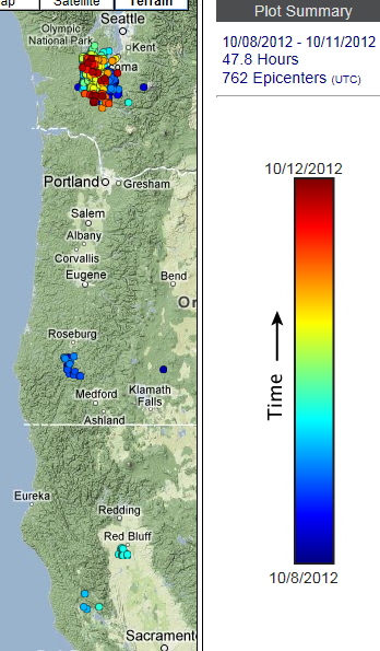
Source
Isaac, that is an interesting observation about the location of the tremor and the Nisqually earthquake location.
Nisqually quake.
The USGS write-up suggests the eq was caused by normal faulting inside the subducting Juan de Fuca because of the slab bending downward more steeply at that point.
The Wiki page (without an attributable source ) says the cause was because of a volume change in the rock due to a mineral phase transition.
Whichever mechanism is correct, maybe the tremor is a symptom of the that process at that location. I did see one graph that looked like the previous episode (to the Nisqually quake) occurred in December 2000. (I can't remember where I found that graph, though )
edit on 10/13/2012 by Olivine because: trying to fix the rolly eyed smiley face
Well, the "official" northern tremor episode is over, but tremor has been picked up everyday but one, since it ended. Almost all of this most
recent tremor has been located in northern California. Here is the map for the past 2 days:
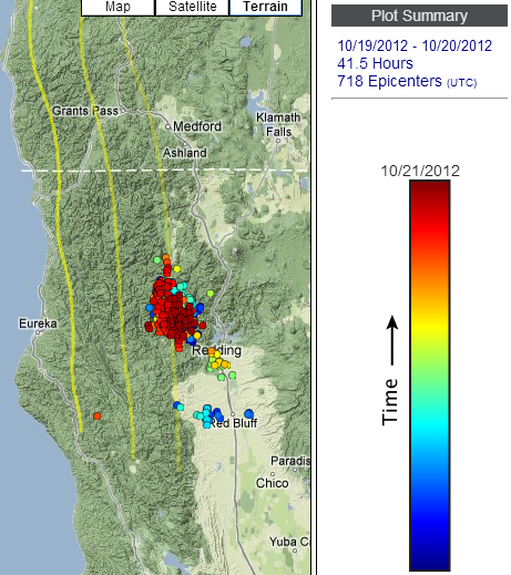
Source--the wech-o-meter (set to show events over time)
The current action looks to be centered directly over station TA.N02D..BHZ. Here are 3 different looks at that station:
New-style PNSN seismo
Old-style PNSN seismo (past 24hrs)
PNSN Spectrogram (todays)
Using the Real-time tremor map it looks as if the tremor was active just before this small Mag 3.5 (USGS) located just over 100 km due west. The depth is listed at 21.7 km, which might put the earthquake on the subduction interface, or possibly in the down-going slab; my best guess looking at the available maps is on the interface.
Just thought I would throw all of this out there; with the Mag 5.3 last night on the San Andreas, some pushing and shoving just north of the Mendocino triple junction doesn't seem unreasonable.
And remember, bolt those bookshelves to the wall.
The ETS centered under Trinity and Siskiyou counties in northern California is continuing. It has not migrated in any particular direction. (On
second look, maybe a tad west, after comparing this map to the one in the post above).
Here is the tremor map for the past 2 days, courtesy of the Pacific Northwest Seismic Network.
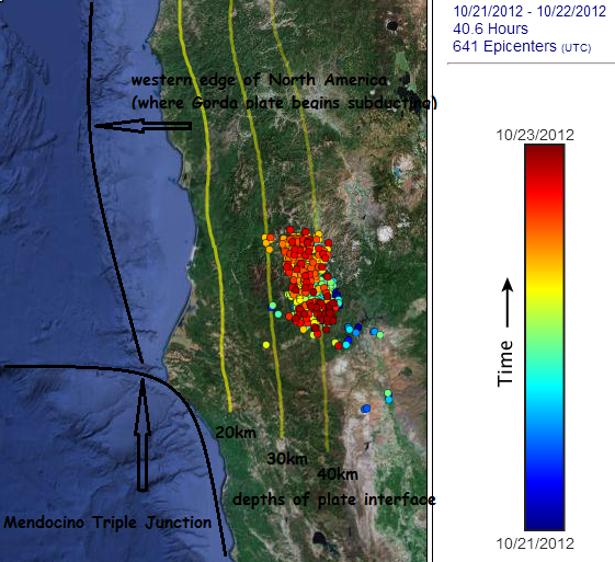
I set the map to show events over time and the satellite view, in order to show the tremor in relation to the subducting Gorda (and further north, Juan de Fuca) plate.
Tremor today is still going strong, as seen on the N02D Spectro.
The jostling among the Pacific, North American, and Gorda plates continued earlier this morning with the Mag 3.7 located just offshore at the Mendocino Triple Junction.
Here is the tremor map for the past 2 days, courtesy of the Pacific Northwest Seismic Network.
I set the map to show events over time and the satellite view, in order to show the tremor in relation to the subducting Gorda (and further north, Juan de Fuca) plate.
Tremor today is still going strong, as seen on the N02D Spectro.
The jostling among the Pacific, North American, and Gorda plates continued earlier this morning with the Mag 3.7 located just offshore at the Mendocino Triple Junction.
edit on 10/23/2012 by Olivine because: add a thought
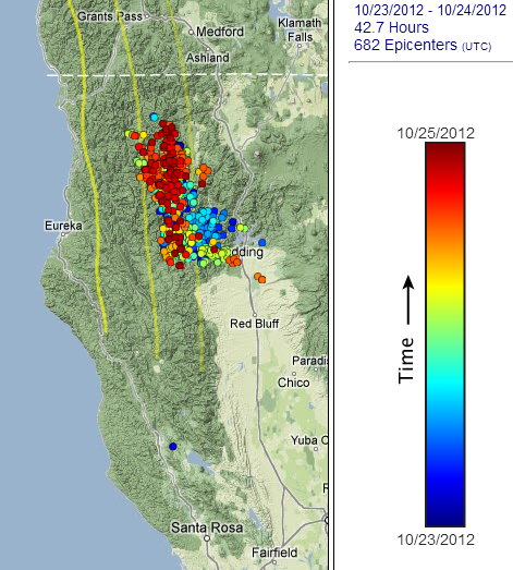
The tremor in northern California continues, and at a very consistent rate over the past 6 days.
Here is the map for the previous 2 days. It looks to be moving NW at a descent clip.Map Source
...as I was typing this post, it looks like another small quake has just happened, possibly just offshore Petrolia, CA. I'll update when I figure it out.
Meh, no listing on USGS yet, but here is the IRIS link for station B932.PB..EHZ in Petrolia.
Small, but you can see it on the USGS Cape Town spectrograph, too (at 12:00 UTC):
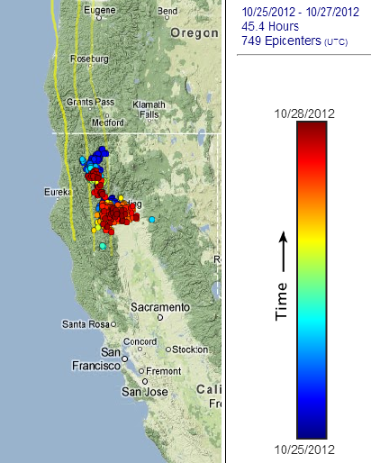
Here is the map for the previous 2 days. It looks to be moving NW at a descent clip.Map Source
...as I was typing this post, it looks like another small quake has just happened, possibly just offshore Petrolia, CA. I'll update when I figure it out.
Meh, no listing on USGS yet, but here is the IRIS link for station B932.PB..EHZ in Petrolia.
edit on 10/25/2012 by Olivine because: add info
Small, but you can see it on the USGS Cape Town spectrograph, too (at 12:00 UTC):
edit on 10/25/2012 by Olivine because: (no reason
given)
Anybody notice this "earthquake" in Oregon at approximately 14:18:45 UTC? Here it is in IRIS
Station B033.PB..EHZ (located just east of
Roseburg).
Something doesn't seem quite right about it, but I can't put a finger on it. I was guessing it was something sonic, but the arrival times on all of the seismos I've checked look too close for it to be sound waves. Still no listing on USGS or PNSN.
It seemed to have abnormally low amplitude for such a long duration event. Scroll down and check out all of the the K*** NC stations on this page. It makes it look like a teleseism, but I don't see anything yet.
I'm curious because the tremor that has been ongoing in northern CA for the past 7 days seems to have decided to jump up and down the entire CSZ today. Check out the past 12 hours on the Realtime tremor map (click the 12 button).
Westcoast, Puter, Muzzy, JohnVidale, Anyone? What do you think? It shows on seismos stretching over 400kms--it was something...
reply to post by Olivine
Wish I could help you out. Good catch. You may have to bump it over to quake watch to get more eyes on it.
Keep up the great work!
Wish I could help you out. Good catch. You may have to bump it over to quake watch to get more eyes on it.
Keep up the great work!
reply to post by Doodle19815
Thanks Doodle.
Well, after some more measuring of the distance between seismic stations and arrival times for those stations,my best estimate is that the waves were traveling approx. 6.75 km/s. That would put them in the seismic range.
I was feeling pretty pleased with myself for working that out, then I checked, USGS again, and found that it was indeed, an earthquake. Go me, lol.
It was waaaay out on the spreading ridge: details here .
So, a good learning exercise--I'm so very slowly getting the hang of this.
edit on 10/26/2012 by Olivine because: rewrite
Things are getting interesting...
First, the ongoing tremor in northern California slowed down on the 25th and 26th, but picked up again yesterday the 27th. Here is the map showing the past 3 days, courtesy of PNSN .
Now, onto the Realtime tremor map. Click on the "12" button; it will list the tremor bursts detected up and down the CSZ over the past 12 hours. And if you scroll down to the bottom of the list, and then hover your mouse over the times and slowly move up the list, you'll see the tremor begin at 20:07:30 under Vancouver Island. Just minutes after the Mag 7.7 hit farther north, on the Queen Charlotte fault.
Here is a map of the Queen Charlotte fault in relation to the northern end of the Cascadia Subduction zone.
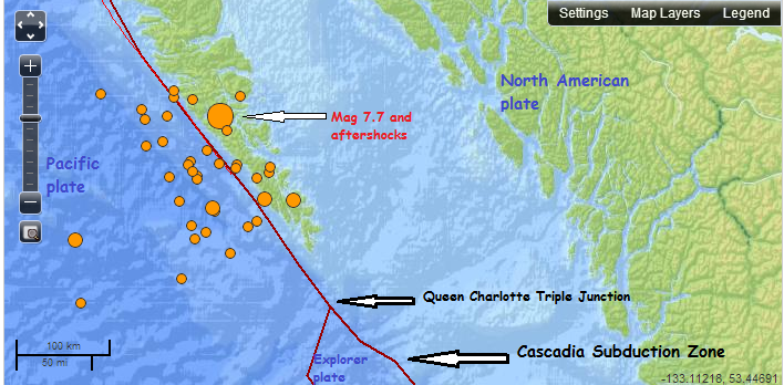
(base map from USGS, I added the graffiti. )
The spread of aftershocks southward is worrisome to me. Here is a quote from John Vidale, found on the PNSN mainpage:
First, the ongoing tremor in northern California slowed down on the 25th and 26th, but picked up again yesterday the 27th. Here is the map showing the past 3 days, courtesy of PNSN .
Now, onto the Realtime tremor map. Click on the "12" button; it will list the tremor bursts detected up and down the CSZ over the past 12 hours. And if you scroll down to the bottom of the list, and then hover your mouse over the times and slowly move up the list, you'll see the tremor begin at 20:07:30 under Vancouver Island. Just minutes after the Mag 7.7 hit farther north, on the Queen Charlotte fault.
Here is a map of the Queen Charlotte fault in relation to the northern end of the Cascadia Subduction zone.
(base map from USGS, I added the graffiti. )
The spread of aftershocks southward is worrisome to me. Here is a quote from John Vidale, found on the PNSN mainpage:
This earthquake likely applied some additional stress to the faults we are concerned with in the Puget Sound and will have local aftershocks that are prominent for weeks. As usual, the chance of further seismic activity in the immediate vicinity of this earthquake will be higher than normal for a while, but does not rise to the level at which any actions are warranted.
edit on 10/28/2012 by Olivine because: spelling
so if cascadia fault goes, and shakes the ground enough to make yellowstone pop, AND causes the new madrid fault to crack... would that be 2012 enough
for everyone. Oh and lets throw a gigantic sun flare in there to, we cant have an electrical grid working when this happens, that would be to easy.
While we are at it, lets say that huge comet coming in 2013 november crashes to earth just to add a cherry.
reply to post by R3KR
Are you being facetious?
I certainly wasn't trying to fearmonger; just pointing out the concurrent activity and slightly elevated risks in the northern CSZ area.
Are you being facetious?
I certainly wasn't trying to fearmonger; just pointing out the concurrent activity and slightly elevated risks in the northern CSZ area.
reply to post by Miraj
Your the Jackass my friend. Trying to blame someone who's pointing out the obvious. I would say to you that knowledge is powerful and the ignorance ain't bliss. Forwarning people of danger is a good thing. It can save lives. Save yourself with your sermon.
Your the Jackass my friend. Trying to blame someone who's pointing out the obvious. I would say to you that knowledge is powerful and the ignorance ain't bliss. Forwarning people of danger is a good thing. It can save lives. Save yourself with your sermon.
Good Morning All
So check out the tremor activity from yesterday.===>
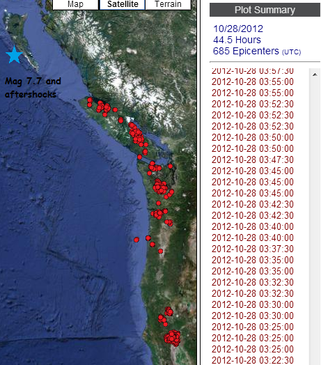 source page for interactive map
That is a lot of random tremor, especially considering that we just finished one of the biggest tremor episodes in the northern portion of the zone on the 12th of October. This last event released (approximately) the moment equivalant of a magnitude 6.5 earthquake, but it did it over 42 days.
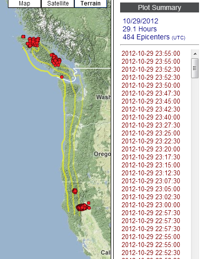
It seems as if the big earthquake up on the Queen Charlotte fault stimulated tremor throughout the northern portion of Cascadia. Maybe the tremor would have happened anyway, even if the Mag 7.7 (and aftershocks) had not occurred; but the timing is curious.
And the tremor is continuing today, as you can see on the realtime tremor map.
The aftershocks from yesterday's quake seem to be slowing, and the slight elevation in risk of a triggered earthquake is heading to zero as time passes....which is all great news.
So check out the tremor activity from yesterday.===>
That is a lot of random tremor, especially considering that we just finished one of the biggest tremor episodes in the northern portion of the zone on the 12th of October. This last event released (approximately) the moment equivalant of a magnitude 6.5 earthquake, but it did it over 42 days.
It seems as if the big earthquake up on the Queen Charlotte fault stimulated tremor throughout the northern portion of Cascadia. Maybe the tremor would have happened anyway, even if the Mag 7.7 (and aftershocks) had not occurred; but the timing is curious.
And the tremor is continuing today, as you can see on the realtime tremor map.
The aftershocks from yesterday's quake seem to be slowing, and the slight elevation in risk of a triggered earthquake is heading to zero as time passes....which is all great news.
edit on 10/29/2012 by Olivine because: format and spelling
edit on 10/29/2012 by Olivine because: (no reason given)
Hello. I was just curious if anyone else in the Pacific Northwest is experiencing strange behavior from their animals? My dog is clingy and hiding
below my feet and the cat is meowing and following us everywhere in the house . . . probably nothing as they might be freaked out by traffic or some
other factor.
Extremely quiet up here lately.
pnsn It's almost eerie.. With all the activity lately around central America, Northern Mexico Baja Mexico it's almost "too" quiet...
pnsn It's almost eerie.. With all the activity lately around central America, Northern Mexico Baja Mexico it's almost "too" quiet...
I'm with you Isaac -
The recent quiet has been incredibly eerie up here, and not setting right with me at all.
The recent quiet has been incredibly eerie up here, and not setting right with me at all.
Hmm, not sure that is a good spot on the Juan De Fuca to have a quake.
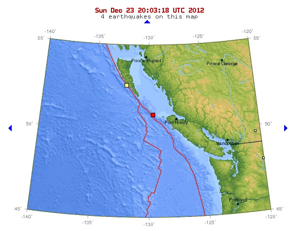
That 4.2 could be said to be an aftershock of the big quake there recently, but they seem to be working their way down the Juan De Fuca plate juncture.
earthquake.usgs.gov...
But according to the historical seismicity map, there have been many there before, so...
neic.usgs.gov...
That 4.2 could be said to be an aftershock of the big quake there recently, but they seem to be working their way down the Juan De Fuca plate juncture.
earthquake.usgs.gov...
But according to the historical seismicity map, there have been many there before, so...
neic.usgs.gov...
edit on Sun Dec 23rd 2012 by TrueAmerican because: (no reason given)
new topics
-
Say his name
US Political Madness: 4 minutes ago -
There is no such thing as moonlight.
Space Exploration: 50 minutes ago -
Breaking: 5 probed after 18-year old girl dies as a result of having the COVID jab
Diseases and Pandemics: 1 hours ago -
Official denial
Diseases and Pandemics: 4 hours ago -
MEGA - Let's Make Europe Great Again
Other Current Events: 4 hours ago -
Hamas and Other Islamist Terrorist Groups Announce Support of US Campus Anti-Israel Protests
Education and Media: 5 hours ago -
Psychotronic Operation Rwanda Who Wants To Be A Refugee?
ATS Skunk Works: 6 hours ago
top topics
-
Breaking: 5 probed after 18-year old girl dies as a result of having the COVID jab
Diseases and Pandemics: 1 hours ago, 6 flags -
Hamas and Other Islamist Terrorist Groups Announce Support of US Campus Anti-Israel Protests
Education and Media: 5 hours ago, 5 flags -
Official denial
Diseases and Pandemics: 4 hours ago, 5 flags -
AI phrenology
Science & Technology: 13 hours ago, 4 flags -
Psychotronic Operation Rwanda Who Wants To Be A Refugee?
ATS Skunk Works: 6 hours ago, 4 flags -
MEGA - Let's Make Europe Great Again
Other Current Events: 4 hours ago, 3 flags -
There is no such thing as moonlight.
Space Exploration: 50 minutes ago, 2 flags -
Say his name
US Political Madness: 4 minutes ago, 0 flags
active topics
-
Big Storms
Fragile Earth • 20 • : SpeedRacer2023 -
Breaking: 5 probed after 18-year old girl dies as a result of having the COVID jab
Diseases and Pandemics • 7 • : Lochid -
University of Texas Instantly Shuts Down Anti Israel Protests
Education and Media • 385 • : burritocat -
Say his name
US Political Madness • 0 • : network dude -
There is no such thing as moonlight.
Space Exploration • 2 • : 5thHead -
Killings of Palestinian children are soaring in the West Bank.
World War Three • 164 • : marg6043 -
MEGA - Let's Make Europe Great Again
Other Current Events • 22 • : BernnieJGato -
Hamas and Other Islamist Terrorist Groups Announce Support of US Campus Anti-Israel Protests
Education and Media • 9 • : marg6043 -
"We're All Hamas" Heard at Columbia University Protests
Social Issues and Civil Unrest • 306 • : Xtrozero -
Official denial
Diseases and Pandemics • 13 • : Justoneman