It looks like you're using an Ad Blocker.
Please white-list or disable AboveTopSecret.com in your ad-blocking tool.
Thank you.
Some features of ATS will be disabled while you continue to use an ad-blocker.

West Coast USA: Pay Attention, Cascadia May Be Ready to Rupture
page: 32share:
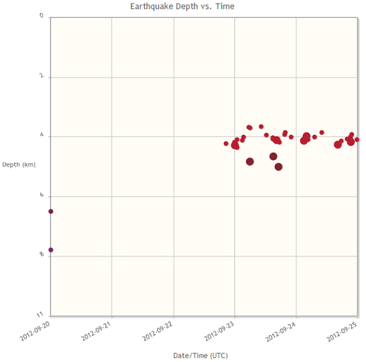
The tremor map for yesterday 14 September shows the activity is still bubbling along...with the northern California burst picking up.
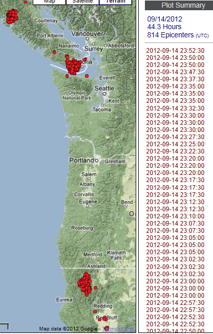
PNSN tremor map
Just an update to report that USGS has listed yesterdays earthquake located offshore of Oregon as a Mag 4.7.
PNSN tremor map
Just an update to report that USGS has listed yesterdays earthquake located offshore of Oregon as a Mag 4.7.
edit on 9/15/2012 by Olivine because: update
PNSN tremor map for the past 2 days.
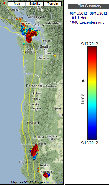
This episode has not stopped. It has died off under the northern end of Vancouver Island, but the southern portion has slid under the Olympic pennisula. Meanwhile, the tremor in northern California looks like it is trying to migrate northward to Oregon.
This blurb is from the PNSN 2012 tremor blog.
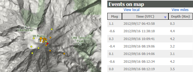
On a related front, Mount Rainier had another spate of tiny earthquakes over the past day.
Lots to monitor in the great Pacific Northwest.
This episode has not stopped. It has died off under the northern end of Vancouver Island, but the southern portion has slid under the Olympic pennisula. Meanwhile, the tremor in northern California looks like it is trying to migrate northward to Oregon.
This blurb is from the PNSN 2012 tremor blog.
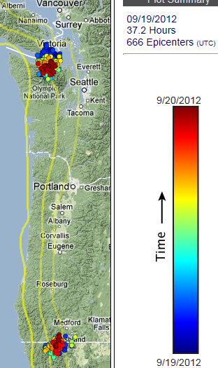
It looks like there is a good chance this will now keep going and fill in the normal 14-month ETS area that goes from southern Vancouver Island to southern Puget Sound. If that is the case it could take another two to three weeks to finish making this one of the longer and largest ETS sequence we have observed. The next couple of days should provide the data to make this prediction more sure (and then it too will probably end up being wrong).
On a related front, Mount Rainier had another spate of tiny earthquakes over the past day.
Lots to monitor in the great Pacific Northwest.
reply to post by Olivine
Yes there is..... Lots of activity and one has to wonder what's coming?
Thanks for all you do!!!
Yes there is..... Lots of activity and one has to wonder what's coming?
Thanks for all you do!!!
reply to post by MamaJ
Thanks MamaJ!.
The tremor episode continues to keep on, keepin' on.
Tremor map for the past 2 days: 91+ total hours, continuing south under the Straits of Juan de Fuca/Olympic mountains. The smaller southern pocket seems stuck at the Oregon border.
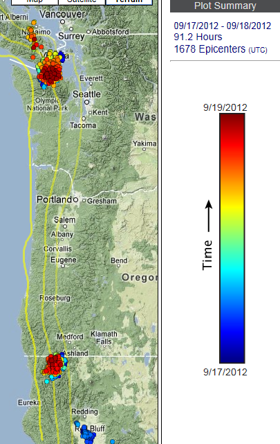
Since the map update yesterday evening, there has been at least 8 hours more tremor detected--so not finished yet. Let's hope the seismicity in the area continues to remain low.
Thanks MamaJ!.
The tremor episode continues to keep on, keepin' on.
Tremor map for the past 2 days: 91+ total hours, continuing south under the Straits of Juan de Fuca/Olympic mountains. The smaller southern pocket seems stuck at the Oregon border.
Since the map update yesterday evening, there has been at least 8 hours more tremor detected--so not finished yet. Let's hope the seismicity in the area continues to remain low.
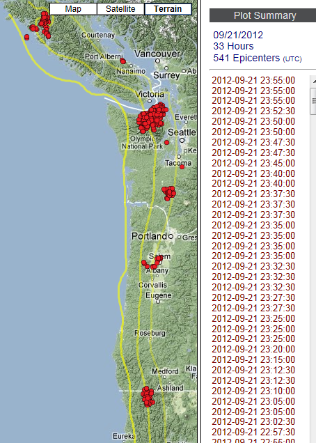
Tremor map for yesterday. Source
Here is the link to the PNSN ETS 2012 blog, commenting on the uniqueness of this episode:
and
and further
It's really interesting to get these scientists' view of the ongoing activity. This seems to be an oddball episode, both in timing of onset and migration pattern.
I'd just like to add, these entire tremor episodes are equivilant to approximately one Magnitude 6+ earthquake. It just takes weeks for the energy to be released: human safe earth adjustments--I like it.
Here is the link to the PNSN ETS 2012 blog, commenting on the uniqueness of this episode:
This ETS seems significantly different...
and
Garry Rogers, who looked back through older Canadian records says: " We have not seen that behaviour before since we have had continuous digital data to analyse; i.e. April 1997 event onwards."
and further
I haven't determined if it is unique yet or not but there have also been periods when this tremor seems VERY strong compared to previous ETS events.
It's really interesting to get these scientists' view of the ongoing activity. This seems to be an oddball episode, both in timing of onset and migration pattern.
I'd just like to add, these entire tremor episodes are equivilant to approximately one Magnitude 6+ earthquake. It just takes weeks for the energy to be released: human safe earth adjustments--I like it.
edit on 9/20/2012 by Olivine because: rewording
So what do you think Cascadia watchers? www.pnsn.org...
Reading the tremor blog (link found on source link above), this current episode seems to be grabbing attention.
They focus on the Vancouver Island/Puget Sound area for study, but I find it creepy that little bursts of tremor are joining in up and down the coast.
(hahaha, I cracked myself up, "creepy" = slow slip = ETS. I'm such a dork )
reply to post by lurksoften
Fantastic! We have have the beginnings of a club--dorks unite!
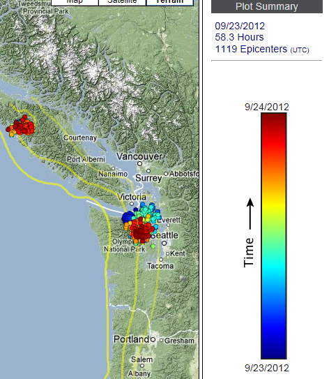
I'm waiting for the next PNSN tremor map update, because after a glance at the spectrogram page, it looks like this episode is continuing with vigor. Check out a few of these:
HDW (east side of Olympic peninsula)(this is "the main" burst that has moved down from Canada over the past weeks)
DBO (southern Oregon, inland from Coos Bay, north of Grants Pass)
If the DBO station is showing tremor (I'm pretty sure it is), and not wind, then it would seem the tremor is spreading into a new area, compared to yesterdays map.
Well, the new map update is in, and all I can say is "Wow". The subduction interface has been busy the past 24 hours.
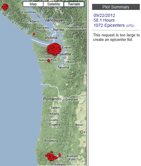
(Image courtesy of the Pacific Northwest Seismic Network--link at top of this post)
Fantastic! We have have the beginnings of a club--dorks unite!
I'm waiting for the next PNSN tremor map update, because after a glance at the spectrogram page, it looks like this episode is continuing with vigor. Check out a few of these:
HDW (east side of Olympic peninsula)(this is "the main" burst that has moved down from Canada over the past weeks)
DBO (southern Oregon, inland from Coos Bay, north of Grants Pass)
If the DBO station is showing tremor (I'm pretty sure it is), and not wind, then it would seem the tremor is spreading into a new area, compared to yesterdays map.
edit on 9/22/2012 by Olivine because: refinements
Well, the new map update is in, and all I can say is "Wow". The subduction interface has been busy the past 24 hours.
(Image courtesy of the Pacific Northwest Seismic Network--link at top of this post)
edit on 9/22/2012 by Olivine because: add a map
Looks like the Gordo plate is twisting. Some activity surrounding it lately. Earlier today I called an earthquake off the central Oregon, Washington
or Vancouver Island coast on my facebook page just for fun. I expect a 4.5 - 5.5 from one of these locations in the next week or less.
Gordo Plate (I think that's it's name)
Gordo Plate (I think that's it's name)
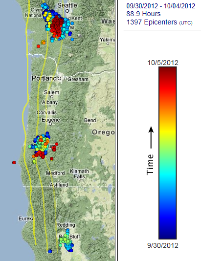
Just wanted to show the current tremor movement over time.
This 1st pic is only showing Vancouver Island and northern Washington envelopes over the past 3 weeks. (There was also tremor that moved north, but I couldn't get it to process. In fact, the pic below only shows about 1/2 of the epicenter locations.)
Both images are from www.pnsn.org/tremor (dark red color is most recent)
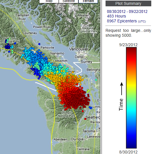
This next pic shows the smaller tremor episode that began a week later in northern California (for the most part) and has marched north into southern Oregon over the past 2 weeks.
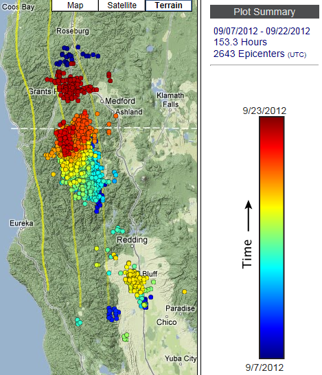
I wonder what the chances are of these 2 packets of tremor meeting in the middle? Say near Portland?
Personally, I don't think the southern bubble of tremor will continue its trek north...but I can certainly be wrong.
At the moment, the tremor under Puget Sound in Washington is particularly strong.
Have a look at the spectrogram from Station HDW Hoodsport, WA over the past hour.
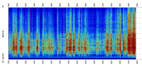 (click to enlarge)
If you are familiar with those glass-top cooking surfaces, and what happens when you heat a heavy pot on one that has water droplets on the bottom of the pan--it pops and skitters furiously--that is how I visualize these tremor events. A lot of tiny pops and a bit of slow skitter or shift at the plate interface, between the under side of the North American continent and the top side of the subducting Juan de Fuca plate. Then the episode ends, when all of the "water droplets" have evaporated; or in the case of the subduction interface, the fluids have migrated away or reached a less volatile state.
I don't know if that is how it really works, but that is how I wrap my head around it.
This 1st pic is only showing Vancouver Island and northern Washington envelopes over the past 3 weeks. (There was also tremor that moved north, but I couldn't get it to process. In fact, the pic below only shows about 1/2 of the epicenter locations.)
Both images are from www.pnsn.org/tremor (dark red color is most recent)
This next pic shows the smaller tremor episode that began a week later in northern California (for the most part) and has marched north into southern Oregon over the past 2 weeks.
I wonder what the chances are of these 2 packets of tremor meeting in the middle? Say near Portland?
Personally, I don't think the southern bubble of tremor will continue its trek north...but I can certainly be wrong.
At the moment, the tremor under Puget Sound in Washington is particularly strong.
Have a look at the spectrogram from Station HDW Hoodsport, WA over the past hour.
 (click to enlarge)
 If you are familiar with those glass-top cooking surfaces, and what happens when you heat a heavy pot on one that has water droplets on the bottom of the pan--it pops and skitters furiously--that is how I visualize these tremor events. A lot of tiny pops and a bit of slow skitter or shift at the plate interface, between the under side of the North American continent and the top side of the subducting Juan de Fuca plate. Then the episode ends, when all of the "water droplets" have evaporated; or in the case of the subduction interface, the fluids have migrated away or reached a less volatile state.
I don't know if that is how it really works, but that is how I wrap my head around it.
edit on 9/23/2012 by Olivine because: rewriting
edit on 9/23/2012 by Olivine because: (no reason given)
Tremor map for yesterday 23 September (UTC).
The tremor in southern Oregon stopped, but the northern Washington event continues its movement southward, and the bubble of tremor under northern Vancouver Island looks to be moving WNW.
The west coast of North America has gotten interesting in the past 24 hours: USGS quake data
Mag 4.5 Talmage, CA,
Mag 6.2 (and aftershocks) in the Gulf of California, Mexico (which are interesting--they don't seem to be located on the spreading center, but in the Pacific plate),
and a Mag 3.6 offshore northern CA and a Mag 4.4 off southern OR.
Here are a few more rumbles you may not have noticed:
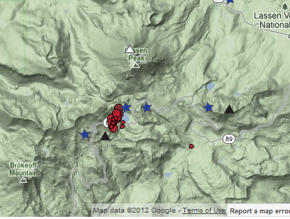
A small swarm of 34 earthquakes under Mt. Lassen in northern California over the past 3 days, clustered 4.0 to 5.5 kms deep. CalVO Lassen Monitoring
Two other Cascade range volcanoes that are normally quiet, each had 1 small tremor this week: Newberry Caldera and Mt. Hood. Volcano Seismicity Page
Up in Washington and Canada, the tremor episode continues.
It almost looks like the main pocket under Puget Sound has stalled it's southern push and has decided to head back north. Maybe?
I'll have to wait until tonights update, in the meanwhile, here is the map of the past 2 days: PNSN tremor map
Mag 4.5 Talmage, CA,
Mag 6.2 (and aftershocks) in the Gulf of California, Mexico (which are interesting--they don't seem to be located on the spreading center, but in the Pacific plate),
and a Mag 3.6 offshore northern CA and a Mag 4.4 off southern OR.
Here are a few more rumbles you may not have noticed:
A small swarm of 34 earthquakes under Mt. Lassen in northern California over the past 3 days, clustered 4.0 to 5.5 kms deep. CalVO Lassen Monitoring
Two other Cascade range volcanoes that are normally quiet, each had 1 small tremor this week: Newberry Caldera and Mt. Hood. Volcano Seismicity Page
Up in Washington and Canada, the tremor episode continues.
It almost looks like the main pocket under Puget Sound has stalled it's southern push and has decided to head back north. Maybe?
I'll have to wait until tonights update, in the meanwhile, here is the map of the past 2 days: PNSN tremor map
edit on 9/26/2012 by Olivine because: add source
reply to post by Olivine
*off topic have ya seen true american around havnt seen any threads from him in awhile?
*off topic have ya seen true american around havnt seen any threads from him in awhile?
And where is John Vidal hiding?
Keep it up Olivine. I have been wondering if the bigger quakes will affect the NW.
Keep it up Olivine. I have been wondering if the bigger quakes will affect the NW.
reply to post by lurksoften
I believe TA is taking a breather to concentrate on a different project.
reply to post by Doodle19815
Hi Doodle.
I miss his input, too. He is probably busy, but he responds to questions quickly on the PNSN's facebook group page.
Take care,
Olivine
I believe TA is taking a breather to concentrate on a different project.
reply to post by Doodle19815
Hi Doodle.
I miss his input, too. He is probably busy, but he responds to questions quickly on the PNSN's facebook group page.
Take care,
Olivine
Well, it looks like the tremor backfilled to the north just a bit, before resuming its movement southward.
A few days ago, the tremor was zipping south along strike at almost 50 km/day, which was extremely fast compared to previous years, according to the 2012 tremor blog (referenced in posts above). The current motion (much slower) is more 'normal' to my eye. Although, since this type of behavior has only been discovered and studied in Cascadia for a little over a decade, I think it is difficult to know what 'normal' truly is.
Picture source
Cheers
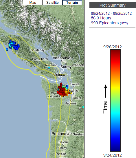
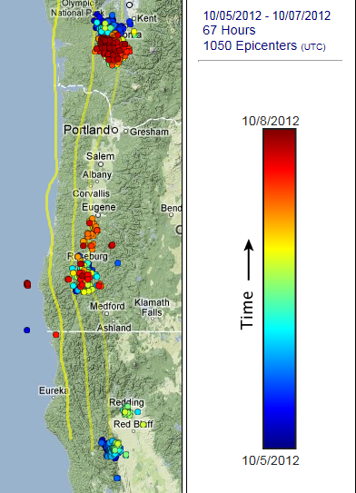
Here is your weekend update for Pacific Northwest tremor over the past 3 days.
Source Map (range 27-29 Sept, Color vs. Time, cropped to fit)
The northern bubble of tremor has either quit, or moved north out of instrument range.
This new group in Oregon began on the 28th, and is continuing, as can be seen on the Dodson Butte spectrogram:
Source Map (range 27-29 Sept, Color vs. Time, cropped to fit)
The northern bubble of tremor has either quit, or moved north out of instrument range.
This new group in Oregon began on the 28th, and is continuing, as can be seen on the Dodson Butte spectrogram:
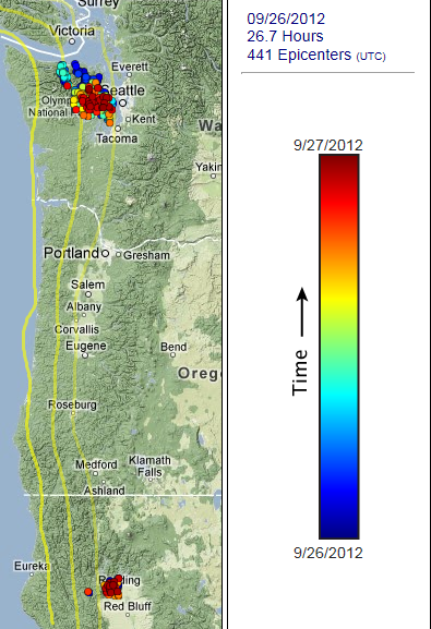
The episodic tremor and slip continues in the PNW, but with much less vigor. Map showing the previous 5 days:
Source (cropped to fit)
Link to 2012 ets main page.
From this link you can get to the Realtime tremor map which, to my eyes, looks like it shows the tremor backtracking to the NW under the Olympics.
The regular earthquake activity in the area seems ho-hum to me. A few Mag 4+ quakes in the Juan de Fuca plate out near the Blanco Fracture Zone, and the volcanoes doing their normal occasional shaking. This very small Mag 2.1 just of Newport, OR could have been on the subduction interface, but the depth uncertainty is so high, who knows?
PNSN reports this episode of tremor as the "most active" ever detected by their system. If it keeps going, it could also be the longest lived; all the while adding just a little more stress to the CSZ.
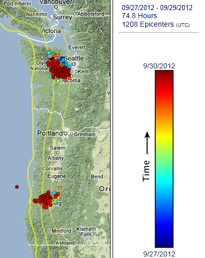
Latest tremor update shows this episode still moving along. Here is the map for the past 3 days.
Source
If the movement continues in its current directions, it looks like the Washington group and the Oregon group just may meet up.
I know it's silly, but I feel like I'm holding my breath watching this episode. Even though the possibility is very, very small, I can't help thinking all this tiny trembling may trigger the entire faultline to slip. Hopefully not; and that event will wait a few hundred more years.
edit on 10/7/2012 by Olivine because: spelling mistakes
I did a search on google to see where the last "mega quake" hit up here in the north west
and came across this article. If you read the article it says
it hit "south west of Seattle". Which I believe is where these tremors seem to stop southern progress, also where the Nisqually earthquake hit a few
years ago. Not trying the doom and gloom trend here. Just an observation..
new topics
-
whistleblower Captain Bill Uhouse on the Kingman UFO recovery
Aliens and UFOs: 2 hours ago -
1980s Arcade
General Chit Chat: 4 hours ago -
Deadpool and Wolverine
Movies: 5 hours ago -
Teenager makes chess history becoming the youngest challenger for the world championship crown
Other Current Events: 6 hours ago -
CIA botched its handling of sexual assault allegations, House intel report says
Breaking Alternative News: 7 hours ago -
Lawsuit Seeks to ‘Ban the Jab’ in Florida
Diseases and Pandemics: 10 hours ago
top topics
-
Lawsuit Seeks to ‘Ban the Jab’ in Florida
Diseases and Pandemics: 10 hours ago, 20 flags -
Starburst galaxy M82 - Webb Vs Hubble
Space Exploration: 12 hours ago, 11 flags -
CIA botched its handling of sexual assault allegations, House intel report says
Breaking Alternative News: 7 hours ago, 8 flags -
The Superstition of Full Moons Filling Hospitals Turns Out To Be True!
Medical Issues & Conspiracies: 13 hours ago, 8 flags -
IDF Intel Chief Resigns Over Hamas attack
Middle East Issues: 17 hours ago, 6 flags -
whistleblower Captain Bill Uhouse on the Kingman UFO recovery
Aliens and UFOs: 2 hours ago, 6 flags -
15 Unhealthiest Sodas On The Market
Health & Wellness: 12 hours ago, 5 flags -
Teenager makes chess history becoming the youngest challenger for the world championship crown
Other Current Events: 6 hours ago, 3 flags -
Deadpool and Wolverine
Movies: 5 hours ago, 3 flags -
1980s Arcade
General Chit Chat: 4 hours ago, 3 flags
active topics
-
1980s Arcade
General Chit Chat • 7 • : Freeborn -
How ageing is" immune deficiency"
Medical Issues & Conspiracies • 24 • : annonentity -
Europe declares war on Russia?
World War Three • 59 • : Freeborn -
George Knapp AMA on DI
Area 51 and other Facilities • 38 • : theshadowknows -
Candidate TRUMP Now Has Crazy Judge JUAN MERCHAN After Him - The Stormy Daniels Hush-Money Case.
Political Conspiracies • 618 • : WeMustCare -
New whistleblower Jason Sands speaks on Twitter Spaces last night.
Aliens and UFOs • 38 • : baablacksheep1 -
-@TH3WH17ERABB17- -Q- ---TIME TO SHOW THE WORLD--- -Part- --44--
Dissecting Disinformation • 605 • : Ektar -
Teenager makes chess history becoming the youngest challenger for the world championship crown
Other Current Events • 3 • : Skinnerbot -
So you don't believe in the devil
Paranormal Studies • 143 • : burritocat -
whistleblower Captain Bill Uhouse on the Kingman UFO recovery
Aliens and UFOs • 5 • : budzprime69