It looks like you're using an Ad Blocker.
Please white-list or disable AboveTopSecret.com in your ad-blocking tool.
Thank you.
Some features of ATS will be disabled while you continue to use an ad-blocker.

At last, The "Watergate" Of 9/11 :
page: 4share:
Originally posted by -PLB-
I must say I have not read everything, it is just way too much text,
Seriously... is this what debunking has come to these days?
Second line.
Originally posted by -PLB-
I took a look on Google Earth, it gives a very high resolution overview of the airport. When you zoom in a bit more you can with almost complete certainty say that the "corrected" flight path is wrong. The plane would have been driving on a lane meant for luggage wagons, and would have driven right through a building. The path I had figured out myself is a perfect fit without any consistencies.
It kind of amazes me how I figured this out in 5 minutes while those pilots for 911 missed it. (ok, not really)edit on 7-8-2011 by -PLB- because: (no reason given)
If the airplane which recorded the data pushed from Gate D26, which is required for the OS to be true, the airplane would have been taxiing on grass and departing from grass south of runway 30.
Source
You can also see that the luggage roadway takes up half of the taxiway, and there is no building in the way.
edit on 7-8-2011 by TigerTracks
because: (no reason given)
reply to post by TigerTracks
It all depends on the "correction" you make. When you scale the path you end up with a perfect match. I would required the raw data to verify any of this.
The building I am talking about can be seen here.
It all depends on the "correction" you make. When you scale the path you end up with a perfect match. I would required the raw data to verify any of this.
The building I am talking about can be seen here.
Originally posted by -PLB-
reply to post by TigerTracks
It all depends on the "correction" you make. When you scale the path you end up with a perfect match. I would required the raw data to verify any of this.
The raw data is provided in the OP.
When you scale the image and lat/long to attempt to line it up with D26 and the taxiways/runway, you get this,
Source
But by all means, see if you can line it up to gate D26, taxiways and runway, and post it here.
The building I am talking about can be seen here.
Understand that you are looking at a 2011 sat image of Dulles. Much has changed at Dulles since 2001. But they didn't move the taxiways and runway 30. It is clear the current luggage road you are looking at is/was a taxiway. Also know that airplanes have the right of way over luggage wagons.
Originally posted by TigerTracks
Originally posted by -PLB-
I would required the raw data to verify any of this.
The raw data is provided in the OP.
Don't make it too easy for him, TigerTracks.
-PLB- has already admitted that he hasn't read everything in the OP. Go figure...
edit on 7-8-2011 by tezzajw because: grammar
Originally posted by tezzajw
Don't make it too easy for him, TigerTracks.
-PLB- has already admitted that he hasn't read everything in the OP. Go figure...edit on 7-8-2011 by tezzajw because: grammar
I'm trying to help him out because I really would like to see what type of concoction he can come up with to line up all the variables required for the OS given the data. It can't be done. Not even the JREFer's were able to do it.
Also, here is the Airport Diagram from 2004. The building -PLB- is referring to is not there.
Source
Furthermore, and as explained at Pilots For 911 Truth, if the airplane pushed from gate D16 or D18, his building argument is moot.
reply to post by TigerTracks
Its sunday, so, ok, I made a quick drawing in paintshop.
[atsimg]http://files.abovetopsecret.com/images/member/2b90e2e04dbe.jpg[/atsimg]
I don't really have a way to verify the raw data, as, according to the OP, you require special software for that.
Its sunday, so, ok, I made a quick drawing in paintshop.
[atsimg]http://files.abovetopsecret.com/images/member/2b90e2e04dbe.jpg[/atsimg]
I don't really have a way to verify the raw data, as, according to the OP, you require special software for that.
edit on 7-8-2011 by -PLB-
because: edited picture
reply to post by TigerTracks
Yeah, fair call. It makes sense to offer your help.
So, -PLB-, it's up to you. Show how you would plot your path, using the 2001 Dulles layout.
Yeah, fair call. It makes sense to offer your help.
So, -PLB-, it's up to you. Show how you would plot your path, using the 2001 Dulles layout.
reply to post by -PLB-
Now use the same length as the red line and line it up to D26. Your creative editing has snipped most of the data points.
You cannot just scale down the path as the lat/long data points will change from the provided data. You need to superimpose the red line, lining up to D26, taxiways and runway. It cannot be done.
edit on 7-8-2011 by TigerTracks because: (no reason given)
reply to post by TigerTracks
The flightpath proposed by pilots for 911 goes right through a building, that building was there in 1991 also. It also goes through grass. So we can say for certain that the path is not correct, and there was no real plane that followed that path. So there are 3 options:
1) The data from the flight recorder is inaccurate.
2) The data is fake and the fakers made an error faking it.
3) The data is valid and the people on pilots for 911 made an error interpreting/reading it.
I find option 3 most likely, although I do not know how I can verify this. You have to take the people from pilots from 911 on their word. Some 3rd party verifying this would make the argument a lot stronger.
edit on 7-8-2011 by -PLB- because: (no reason given)
Originally posted by -PLB-
The flightpath proposed by pilots for 911 goes right through a building, that building was there in 1991 also.
Perhaps, do you have a source? 1991 is not 2001.
But what we do know is that the building was not there in 2004. You may have missed this post.
www.abovetopsecret.com...
Also, here is an image at perfect scale based on lat/long points.
Take that image, line it up to D26, taxiways, and runway. Do not change scale of the superimposed image or you will change the lat/long data provided by the NTSB, and the width and lengths of the taxiways and runway.
edit on 7-8-2011 by TigerTracks because: (no reason given)
Originally posted by TigerTracks
Perhaps, do you have a source? 1991 is not 2001.
But what we do know is that the building was not there in 2004. You may have missed this post.
www.abovetopsecret.com...
That map doesn't have enough detail to see the building. If you use Google earth you can see the building being there in 4-1991, 4-2002, 12-2002, 9-2003, 9-2005, 10-2006, 4-2007 etc.
Also, here is an image at perfect scale based on lat/long points.
Take that image, line it up to D26, taxiways, and runway. Do not change scale of the superimposed image or you will change the lat/long data provided by the NTSB, and the width and lengths of the taxiways and runway.
I understand that scaling screws up the lon/lat data. But I do not really have a way to verify this data to begin with. Google mostly shows 911 conspiracy sites when I type "longitude latitude flight data recorder". Where can I find the original data?
edit on 7-8-2011 by -PLB- because:
(no reason given)
Originally posted by -PLB-
That map doesn't have enough detail to see the building. If you use Google earth you can see the building being there in 4-1991, 4-2002, 12-2002, 9-2003, 9-2005, 10-2006, 4-2007 etc.
From my post above -
Furthermore, and as explained at Pilots For 911 Truth, if the airplane pushed from gate D16 or D18, his building argument is moot.
I understand that scaling screws up the lon/lat data. But I do not really have a way to verify this data to begin with. Google mostly shows 911 conspiracy sites when I type "longitude latitude flight data recorder". Where can I find the original data?edit on 7-8-2011 by -PLB- because: (no reason given)
It's in the original post. But if you want your own from the absolute original source, www.ntsb.gov...
Google NTSB FOIA Request next time. Came up on my first hit. From what I understand, they are pretty quick in responding.
reply to post by TigerTracks
Thanks for pointing that out, I had already found it though.
I loaded the original GPS data into Google earth. And I can confirm it is correct. But I also found out something else.
The data also contains visits to other airports, so I looked at that data as reference. After checking that, the conclusion is simple: the data is not at all that accurate. In the data at other airports you can see the plane driving on parking lots, through terminals etc, after correcting the position. Here are Google earth screenshots:
[atsimg]http://files.abovetopsecret.com/images/member/e1b8ecffc001.jpg[/atsimg]
I invite anyone to confirm this. For me its case closed.
Originally posted by -PLB-
reply to post by TigerTracks
Thanks for pointing that out, I had already found it though.
I loaded the original GPS data into Google earth. And I can confirm it is correct. But I also found out something else.
American Airlines Flight 77, N644AA, was not GPS equipped, this is further evidence that the data is not from "AA77". Read more here,
Overwhelming Evidence Pentagon Aircraft Data Is Not From An American Airlines 757
Also, none of your images line up with Dulles Gate D26, the taxiways and runways, as you said you would provide.. Possibly because you have figured out it is impossible to line up the data in such a way?
reply to post by TigerTracks
Yes it is impossible to line up the data accurately. Whatever position you choose, you end up hitting buildings, driving through grass etc. Similar to the other two airports I checked. In other words, the data is not accurate enough to determine at which gate the plane arrived or departed.
I must correct myself, it indeed nowhere said it was GPS data, I just assumed it was. I don't know much about IRS, but I suspect that this system is only accurate when the plane is in the air. But only an expert can really comment on that.
edit on 7-8-2011 by -PLB- because: (no reason
given)
Originally posted by -PLB-
reply to post by TigerTracks
Yes it is impossible to line up the data accurately.
It is impossible to line up the data to Gate D26 at Dulles, I agree. Unfortunately, that is what is required for the OS to be true.
Whatever position you choose, you end up hitting buildings, driving through grass etc. Similar to the other two airports I checked. In other words, the data is not accurate enough to determine at which gate the plane arrived or departed.
All lat/long data is offset and then aligns in flight. This is more evidence the data cannot be from "AA77". Click the link I provided above.
I must correct myself, it indeed nowhere said it was GPS data, I just assumed it was.
In fact, the GPS column in the data shows the GPS as operational. This is more evidence the data cannot be from "AA77". Click the link I provided above.
I don't know much about IRS, but I suspect that this system is only accurate when the plane is in the air. But only an expert can really comment on that.edit on 7-8-2011 by -PLB- because: (no reason given)
Many did including Captains from American Airlines. Click the link I provided above. IRS is fully aligned at the gate prior to every flight according to American Airlines pre-flight checklist.
Pilots input the current gate lat/long coordinates. The data should have been aligned to the gate if the data came from "AA77".
Parking Gate Coordinates For IRS Input.
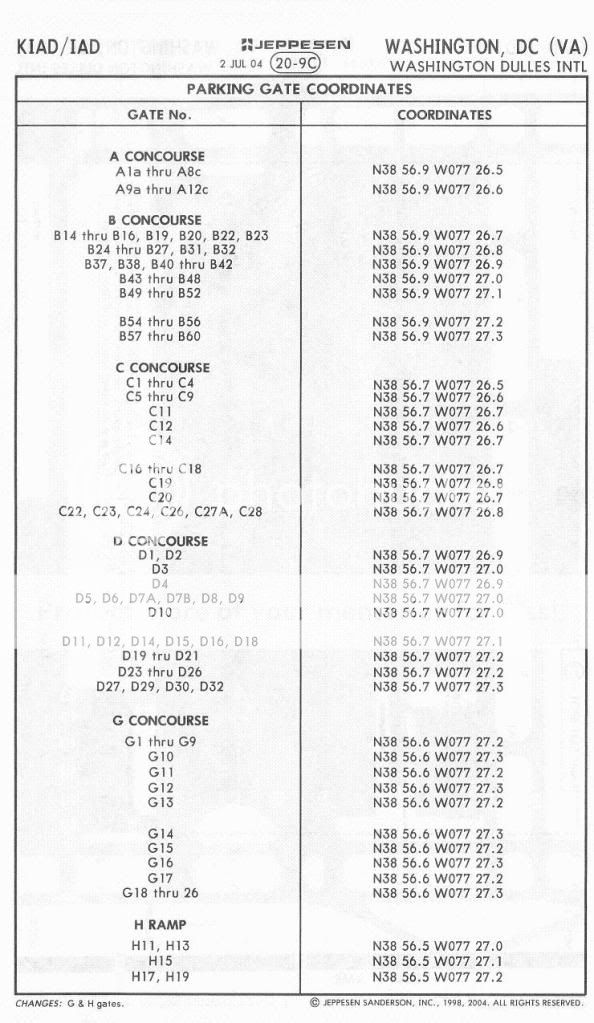
Since all data shows thousands of feet offset at all airports, this is further evidence the data is not from "AA77".
edit on 7-8-2011 by
TigerTracks because: (no reason given)
reply to post by TigerTracks
There are basically two questions that need answers, how accurate is the IRS (required to be) when the plane is on the ground and what position do pilots use as reference coordinates at the gate. We can for certain say that the data is not very accuracy when the plane is on the ground. This can be normal for an IRS, or it can mean that the IRS was malfunctioning, or it can mean that the data has been tampered with. I suspect it is normal for an IRS. As for which coordinates pilots use, only pilots can answer that.
There are basically two questions that need answers, how accurate is the IRS (required to be) when the plane is on the ground and what position do pilots use as reference coordinates at the gate. We can for certain say that the data is not very accuracy when the plane is on the ground. This can be normal for an IRS, or it can mean that the IRS was malfunctioning, or it can mean that the data has been tampered with. I suspect it is normal for an IRS. As for which coordinates pilots use, only pilots can answer that.
Originally posted by -PLB-
reply to post by TigerTracks
There are basically two questions that need answers, how accurate is the IRS (required to be) when the plane is on the ground and what position do pilots use as reference coordinates at the gate. We can for certain say that the data is not very accuracy when the plane is on the ground. This can be normal for an IRS, or it can mean that the IRS was malfunctioning, or it can mean that the data has been tampered with. I suspect it is normal for an IRS. As for which coordinates pilots use, only pilots can answer that.
The coordinates the pilots use to input lat/long into the IRS are above your post and the post you replied to. They use the lat/long coordinates at the gate. Pilots cannot depart with an IRS malfunctioning, nor will they depart the gate without the IRS fully aligned to the gate.
Read more here from a conversation with an American Airlines Captain.
Click
Originally posted by ipsedixit
I personally believe that a large airliner or equivalent aircraft did not impact the Pentagon. To this point I have been convinced by the CIT presentations and those of Pilots for 9/11 Truth.
I also do not personally believe that a large 757 crashed into the Pentagon. However, there are far too many witnesses that visually saw a plane impact the Pentagon and far too few that saw a "fly-over".
With that said, maybe a smaller jet is what likely struck the Pentagon. Too many people saw the impact, so there was an impact of some kind of jet.
And as I stated earlier in this thread, CIT's hostile and unprofessional manner automatically makes them lose credibility points, on top of the fact that many of their "theories" are ridiculous and baseless.
new topics
-
Really Unexplained
Paranormal Studies: 3 hours ago -
The Vaccine Injured
Medical Issues & Conspiracies: 3 hours ago -
Leading Surgeon from Al-Shifa Hospital Dies in Israeli Custody
Middle East Issues: 6 hours ago -
Zionists of ATS assemble
Political Issues: 10 hours ago
top topics
-
EPA sues San Francisco for dumping billions of gallons of sewage into Pacific Ocean
US Political Madness: 15 hours ago, 10 flags -
For Votes - President BIDEN Opens ObamaCare Health Ins to Illegal Aliens Eff Nov 1st 2024.
2024 Elections: 15 hours ago, 10 flags -
Zionists of ATS assemble
Political Issues: 10 hours ago, 9 flags -
Leading Surgeon from Al-Shifa Hospital Dies in Israeli Custody
Middle East Issues: 6 hours ago, 5 flags -
The Vaccine Injured
Medical Issues & Conspiracies: 3 hours ago, 3 flags -
Really Unexplained
Paranormal Studies: 3 hours ago, 2 flags -
Prophets versus priests; - Getting God's help
Religion, Faith, And Theology: 17 hours ago, 0 flags
active topics
-
Post A Funny (T&C Friendly) Pic Part IV: The LOL awakens!
General Chit Chat • 7153 • : baddmove -
Killings of Palestinian children are soaring in the West Bank.
World War Three • 168 • : cherokeetroy -
Poll - Catholic Support Swings to Trump By Significant Margin
2024 Elections • 38 • : andy06shake -
Really Unexplained
Paranormal Studies • 7 • : Beesnestbomber -
Leading Surgeon from Al-Shifa Hospital Dies in Israeli Custody
Middle East Issues • 31 • : StoutBroux -
Wounded Orangutan seen using a Plant as Medicine for the First Time
Fragile Earth • 27 • : jofafot -
Candidate TRUMP Now Has Crazy Judge JUAN MERCHAN After Him - The Stormy Daniels Hush-Money Case.
Political Conspiracies • 1147 • : Annee -
Zionists of ATS assemble
Political Issues • 56 • : Justoneman -
UN Estimates Rebuilding Gaza Will Cost Up To 40 Billion Dollars
Middle East Issues • 64 • : Zeyin -
SEC shuts down Trump Media auditor, BF Borgers, over fraud
Mainstream News • 51 • : ByeByeAmericanPie