It looks like you're using an Ad Blocker.
Please white-list or disable AboveTopSecret.com in your ad-blocking tool.
Thank you.
Some features of ATS will be disabled while you continue to use an ad-blocker.

Quake Watch 2011
page: 369share:
Originally posted by AuntB
Wow, what a find Olivine. I click on the USGS quite often but many of the earthquakes on Earthscope ANF are not listed on USGS. What is correct? Also, the LA ABC live quake cam went off this week. I figured it was broke but now are they just hiding stuff?
I also noticed that the Earthscope ANF site doesn't have the Utah quakes.edit on 11-11-2011 by AuntB because: (no reason given)
Yea - what's up with that? It's uncomfortable seeing a 5.0 off of our coast and not having a live cam available to see if it happened or not. I've written them at live cam - as I'm sure many others have.
reply to post by diamondsmith
what reports?
there is 20 seconds between the first and the last time wise on that emsc list
what reports?
there is 20 seconds between the first and the last time wise on that emsc list
edit on 11-11-2011 by muzzy because: (no reason given)
reply to post by diamondsmith
I don't see it, there is 3 seconds difference
USGS - 5.2 2011/11/11 19:00:47 -22.750 168.268 130.7 NEW CALEDONIA
EMSC - 5.2 2011-11-11 19:00:44.01 22.80 S 168.76 E 90 NEW CALEDONIA
BTW if you want to quickly compare the 3 main networks results without having to open all 3 pages/ tabs this site can be handy. www.oe-files.de...
Once you find the event you want unclick the "follow" box (right hand lower corner) and then select which network you want the details of.
seems the USGS markers are currently having shrinkage problems at the moment.
In fact my NZ Blog is having marker problems too, some days aren't showing the markers at all, it may be something to do with i-frames and Google Maps as I use the same formula as Live Earthquake Maps.
edit:
I just did what I described myself above and is this what you mean?
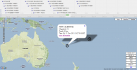
the tag off emsc on Live Earthquakes for New Caledonia shows this
NEW CALEDONIA
Magnitude: 5.2
Depth: 90 km
Time: Fri, 11 Nov 2011 19:27:00 GMT
27 minutes difference to what it shows on the emsc page itself when you click "more information"
must be a glitch in the system
I don't see it, there is 3 seconds difference
USGS - 5.2 2011/11/11 19:00:47 -22.750 168.268 130.7 NEW CALEDONIA
EMSC - 5.2 2011-11-11 19:00:44.01 22.80 S 168.76 E 90 NEW CALEDONIA
BTW if you want to quickly compare the 3 main networks results without having to open all 3 pages/ tabs this site can be handy. www.oe-files.de...
Once you find the event you want unclick the "follow" box (right hand lower corner) and then select which network you want the details of.
seems the USGS markers are currently having shrinkage problems at the moment.
In fact my NZ Blog is having marker problems too, some days aren't showing the markers at all, it may be something to do with i-frames and Google Maps as I use the same formula as Live Earthquake Maps.
edit on 11-11-2011 by muzzy because: (no reason given)
edit:
I just did what I described myself above and is this what you mean?
the tag off emsc on Live Earthquakes for New Caledonia shows this
NEW CALEDONIA
Magnitude: 5.2
Depth: 90 km
Time: Fri, 11 Nov 2011 19:27:00 GMT
27 minutes difference to what it shows on the emsc page itself when you click "more information"
must be a glitch in the system

edit on 11-11-2011 by muzzy because: (no reason given)
reply to post by StealthyKat
reply to post by spinkyboo
I know, creepy right? And that big blue square of the coast of Massachusetts? That's why I was asking for input from members.
Seems remarkable that those schools are the only folks to record these quakes. Scripps Institution of Oceanography is well regarded; and it makes some sense that they could have a leg up on open water earthquakes. I'm not sure about UCSD's seismology department.
reply to post by muzzy
Hard to understand depend on the time zone,still this one nowhere
Date: Fri, 11 Nov 2011 19:30 +0000 UTC
BEGIN GSE2.0
MSG_TYPE DATA
MSG_ID db738 SC3
REF_ID 201111111915 SC3
DATA_TYPE BULLETIN GSE2.0
EVENT GAQDI 20111111191533
Date Time Latitude Longitude Depth Ndef Nsta Gap Mag1 N Mag2 N Mag3 N Author ID
rms OT_Error Smajor Sminor Az Err mdist Mdist Err Err Err Quality
2011/11/11 19:15:33.3 36.7656 38.3147 337.3 14 14 184 mb 4.3 12 SC3 db738
9.3 6.9 +- 8.5 4.41 100.67 +-0.3 a i uk
TURKEY-SYRIA BORDER REGION
Sta Dist EvAz Phase Date Time TRes Azim AzRes Slow SRes Def SNR Amp Per Mag1 Mag2 ID
VANB 4.41 64.0 a P 2011/11/11 19:16:47.3 1.3 T 0.6 ML 4.5 SC3
AGRB 4.63 51.2 a P 2011/11/11 19:16:46.1 -1.4 T 0.2 ML 4.0 SC3
ARG 8.21 269.2 a P 2011/11/11 19:17:29.0 -0.2 T 31.5 0.57 mb 4.4 SC3
KBA 21.12 307.1 a P 2011/11/11 19:20:07.7 15.4 T SC3
PRU 21.60 315.2 a P 2011/11/11 19:19:59.6 2.7 T 4.5 3.74 mb 3.0 SC3
KHC 21.77 312.4 a P 2011/11/11 19:20:02.2 3.7 T 10.1 1.69 mb 3.7 SC3
WET 22.19 311.9 a P 2011/11/11 19:20:05.9 3.5 T 30.9 2.44 mb 4.0 SC3
WTTA 22.27 306.5 a P 2011/11/11 19:20:12.1 8.8 T SC3
BRG 22.36 316.8 a P 2011/11/11 19:19:58.1 -5.9 T 15.0 1.50 mb 4.0 SC3
FUORN 22.98 304.2 a P 2011/11/11 19:20:10.9 0.9 T 30.6 0.86 mb 4.5 SC3
DAVA 23.42 305.6 a P 2011/11/11 19:20:14.8 0.9 T 30.8 1.54 mb 4.3 SC3
TUE 23.56 303.4 a P 2011/11/11 19:20:12.1 -3.1 T 39.0 0.91 mb 4.7 SC3
MUGIO 23.64 302.0 a P 2011/11/11 19:20:12.1 -3.8 T 26.8 1.11 mb 4.4 SC3
FLT1 24.54 318.0 a P 2011/11/11 19:20:24.6 0.8 T 17.6 2.24 mb 4.0 SC3
TAM 31.49 252.9 a P 2011/11/11 19:21:26.0 0.9 T 15.3 0.82 mb 4.5 SC3
SPB 100.67 248.4 a P 2011/11/11 19:28:43.0 -0.5 T 28.0 0.80 mb 5.8 SC3
PFO 105.80 338.4 a P 2011/11/11 19:29:23.4 15.0 T SC3
STOP
emsc-csem.org/Earthquake/alert/?id=db738;SC3&date=2011-11-11)source
reply to post by AuntB
Hi AuntB,
I noticed that the map was missing many USGS listed quakes, too. I think it is because they mostly list events recorded by the Transportable Array, which doesn't cover all of the United States (they are working on it). Clicking on a few of the earthquakes, I also suspect that Mag 5, 15km depth are default parameters in their system.
I guess we can just use this page as another source of info, but look for corroboration of the data from other networks (like muzzy so expertly does).
Cheers
edit on 11/11/2011 by Olivine because: (no reason given)
reply to post by Olivine
Yes it is....I HAVE to know if it's correct....I have a home on the gulf coast. This has me concerned. How can I verify that there were 2 aprox mag 5 earthquakes in the gulf of mexico? All I know about was a 6.0 in the gulf in 2006 I think....does anyone know how I can determine if it's true?
Yes it is....I HAVE to know if it's correct....I have a home on the gulf coast. This has me concerned. How can I verify that there were 2 aprox mag 5 earthquakes in the gulf of mexico? All I know about was a 6.0 in the gulf in 2006 I think....does anyone know how I can determine if it's true?
edit on 11/11/2011 by StealthyKat because: (no reason given)
reply to post by diamondsmith
as far as I am aware its all UTC (or old Greenwich Mean Time)
No I think Live Earthquakes is broken
this one off a LiveEQ tag
TURKEY-SYRIA BORDER REGION
Magnitude: 3.0
Depth: 7 km
Time: Fri, 11 Nov 2011 18:01:00 GMT
but inside more infomation on emsc
Magnitude MD 3.0
Region TURKEY-SYRIA BORDER REGION
Date time 2011-11-11 16:53:57.0 UTC
Location 36.65 N ; 36.49 E
Depth 7 km
neither match with the one on emsc data contributions I was talking about
2011-11-11 19:15:33.3 36.77 N 38.31 E 337 mb 4.3 A TURKEY-SYRIA BORDER REGION SC3
or even
2011-11-11 18:10:16.7 38.69 N 43.74 E 2 A EASTERN TURKEY MIX
something is all messed up
edit on 11-11-2011 by muzzy because: (no reason given)
edit on 11-11-2011 by muzzy because: (no
reason given)
reply to post by muzzy
You have something like this in NZE?that will be great for every active region to see!!!!!!
digisonde.haarp.alaska.edu...
digisonde.haarp.alaska.edu...
reply to post by diamondsmith
theres nothing on KOERI (Turkey EQ web site) that matches either
www.koeri.boun.edu.tr...
must be a false reading
theres nothing on KOERI (Turkey EQ web site) that matches either
www.koeri.boun.edu.tr...
must be a false reading
So am I the only one who noticed the 4.2 in western Montana?
Now, I know that's nothing too big, but.. western Montana? Am I missing something here? Seems a little odd, we had that 5.8 in Virginia, that 5.6 (6?) in Oklahoma, the 4 in Utah, the 4 in Nevada, (wasn't there another 4-5~ in Texas/New Mexico?) and now one in western Montana?
At this rate, all 50 states will have had a quake by the end of the year. Place your bets on whose next.
edit on 11-11-2011 by Lionhearte
because: (no reason given)
reply to post by muzzy
Something like this or a sky map,total content of electrons in a time frame refering to to direction and altitude and many other things!!
www.haarp.alaska.edu...
or more complex...
digisonde.haarp.alaska.edu...
could show time prediction to emission absorption electron total mass/time frame/direction
www.haarp.alaska.edu...
or more complex...
digisonde.haarp.alaska.edu...
could show time prediction to emission absorption electron total mass/time frame/direction
reply to post by StealthyKat
Well I have looked at the 5.0mb on the 8th Nov and I believe that is an error.
There is a very slight signal on 035Z.TA..BHZ.2011.312 and on JRQG.MG..HHZ.2011.312
On the first one the black trace is NOT Taiwan as it is too early. Taiwan 6.9 was 02:29 UTC. The travel time to that area is between 14 and 15 minutes (estimates) for the P-wave and the time of that supposed 5.0mb is 03:24 UTC which I believe is the S-wave of the Taiwan quake going through which has been incorrectly identified.
The other one on the 2nd was 19:03 just 2 minutes after Costa Rica and in the right time spread more or less but 035Z.TA..BHZ.2011.306 which is the closest TA instrument really does not show it. Neither does JRQG.MG..HHZ.2011.306. I am think this is also possibly an error.
Looking at some more....
Closest station to the big red blob on the Pacific is HILB.PT..HHZ.2011.306
Data from Earthscope
I don't see it. Does anyone else? Believe me if that one can't see I am darn sure the ones on the coast of America can't.
And the other red blob at 15:10 today? SBC.CI..BHZ.2011.315 Nothing unless it was reading Tonga!!! - Oh looky me just the right travel time!
So far I pick 4 and found 4 probable errors. I think I will scrub that site. They are all computer generated and we know what computers are like!!
Well I have looked at the 5.0mb on the 8th Nov and I believe that is an error.
There is a very slight signal on 035Z.TA..BHZ.2011.312 and on JRQG.MG..HHZ.2011.312
On the first one the black trace is NOT Taiwan as it is too early. Taiwan 6.9 was 02:29 UTC. The travel time to that area is between 14 and 15 minutes (estimates) for the P-wave and the time of that supposed 5.0mb is 03:24 UTC which I believe is the S-wave of the Taiwan quake going through which has been incorrectly identified.
The other one on the 2nd was 19:03 just 2 minutes after Costa Rica and in the right time spread more or less but 035Z.TA..BHZ.2011.306 which is the closest TA instrument really does not show it. Neither does JRQG.MG..HHZ.2011.306. I am think this is also possibly an error.
Looking at some more....
Closest station to the big red blob on the Pacific is HILB.PT..HHZ.2011.306
Data from Earthscope
Latitude 19.6723
Longitude -143.2005
Magnitude 5.0 mb
Depth 15 km
UTC Time 15:08:11 UTC Friday November 11th, 2011
Location North Pacific Ocean, Pacific Basin
Author teleMb
I don't see it. Does anyone else? Believe me if that one can't see I am darn sure the ones on the coast of America can't.
And the other red blob at 15:10 today? SBC.CI..BHZ.2011.315 Nothing unless it was reading Tonga!!! - Oh looky me just the right travel time!
So far I pick 4 and found 4 probable errors. I think I will scrub that site. They are all computer generated and we know what computers are like!!
edit on 11/11/2011 by PuterMan because: (no reason given)
reply to post by muzzy
Have not the foggiest as I am not into poking the ionosphere with radio waves!
www.haarp.alaska.edu...
Have not the foggiest as I am not into poking the ionosphere with radio waves!
The HAARP Digisonde, which was developed and provided by the University of Massachusetts at Lowell, was one of the first instruments installed at the HAARP Research Station. The purposes of this instrument are to support frequency management of the 3600 kilowatt Ionospheric Research Instrument transmitter and to provide real time ionospheric characteristics for guiding experiment selection. The Digisonde data are processed, archived, and are available for post-analysis of experiment results
www.haarp.alaska.edu...
Originally posted by PuterMan
reply to post by angelchemuel
So last night was the full moon and nothing happened. Tonight is the end of the word because it is 11-11-11 or something so what is in store for the rest of the week end?
I would have thought that it the knicker elastic breaks you would be too busy to go commando to TAs thread. However, in the same vein as the Captain of the Titanic's "what iceberg?", I shall say "what earthquake?" I am not expecting any earthquake.
By the way RSOE on those supervolcanoes pages often just slam up all the quakes so they do appear under two or more different areas. It is what is know as being incompetent.
Now I am going to have to spend the weekend decontaminating myself.
Never said I was going to 'drop my knickers' on full moon...said it was going to be an interesting week end.
What's the date got to do with ANYTHING?
Never worried about going commando on the odd occasion...too much info! But if I feel my elastic go 'ping' then I might just have a 'prediction' for TA!
Pfff....EDIS...we've covered this in the past about the supers, and you know I agree with you...just thought this one was a bit odd.
Sorry I made you feel sick
Earthquake Rainbows
Jane
reply to post by angelchemuel
Mm, let's forget the elastic. The date 11-11-11 is supposed to be the end of the world, another one. That is what the date was about. Still got an hour to go so I suppose it could happen yet.
Still waiting for this prediction which I was assuming had something to do with the full moon. Perhaps not?
Mm, let's forget the elastic. The date 11-11-11 is supposed to be the end of the world, another one. That is what the date was about. Still got an hour to go so I suppose it could happen yet.
Still waiting for this prediction which I was assuming had something to do with the full moon. Perhaps not?
reply to post by muzzy
Which is why I have never linked it, because I didn't want to have to answer the inevitable 20 million questions that would result. That is raw data. Very dangerous in the hands of would be, alarmist quake watchers.
I also know of another site, but no, just no. Do yourselves a big favor and just trash that link to earthscope quakes, or you're all going to drive us insane. Go by the USGS, or EMSC and save the world 20 million posts of questions about man made activity.
reply to post by TrueAmerican
I don't know much about earthquakes, but I clicked on that link and I couldn't believe they were saying there were 2 magnitude 5 quakes in the Gulf Of Mexico. If that were true, it would be on the USGS site right? How can they get away with putting out false info like that.....I mean, do they just close thier eyes, spin around 3 times, and point to any spot on the map?? That really ticks me off. Thanks for letting us know it's BS!
I don't know much about earthquakes, but I clicked on that link and I couldn't believe they were saying there were 2 magnitude 5 quakes in the Gulf Of Mexico. If that were true, it would be on the USGS site right? How can they get away with putting out false info like that.....I mean, do they just close thier eyes, spin around 3 times, and point to any spot on the map?? That really ticks me off. Thanks for letting us know it's BS!
new topics
-
Mike Pinder The Moody Blues R.I.P.
Music: 28 minutes ago -
Putin, Russia and the Great Architects of the Universe
ATS Skunk Works: 3 hours ago -
A Warning to America: 25 Ways the US is Being Destroyed
New World Order: 7 hours ago
top topics
-
President BIDEN's FBI Raided Donald Trump's Florida Home for OBAMA-NORTH KOREA Documents.
Political Conspiracies: 13 hours ago, 31 flags -
A Warning to America: 25 Ways the US is Being Destroyed
New World Order: 7 hours ago, 13 flags -
Is AI Better Than the Hollywood Elite?
Movies: 15 hours ago, 4 flags -
Mike Pinder The Moody Blues R.I.P.
Music: 28 minutes ago, 2 flags -
Maestro Benedetto
Literature: 15 hours ago, 1 flags -
Putin, Russia and the Great Architects of the Universe
ATS Skunk Works: 3 hours ago, 1 flags
active topics
-
Truth Social goes public, be careful not to lose your money
Mainstream News • 132 • : matafuchs -
New whistleblower Jason Sands speaks on Twitter Spaces last night.
Aliens and UFOs • 67 • : Ophiuchus1 -
Gaza Terrorists Attack US Humanitarian Pier During Construction
Middle East Issues • 57 • : ToneD -
Mike Pinder The Moody Blues R.I.P.
Music • 1 • : RussianTroll -
Putin, Russia and the Great Architects of the Universe
ATS Skunk Works • 11 • : CriticalStinker -
Mood Music Part VI
Music • 3106 • : TheWoker -
University of Texas Instantly Shuts Down Anti Israel Protests
Education and Media • 275 • : Vermilion -
President BIDEN's FBI Raided Donald Trump's Florida Home for OBAMA-NORTH KOREA Documents.
Political Conspiracies • 22 • : 320MPH -
A Warning to America: 25 Ways the US is Being Destroyed
New World Order • 19 • : Cvastar -
Alternate Electors vs Fake Electors - What is the Difference.
2024 Elections • 118 • : Threadbarer