It looks like you're using an Ad Blocker.
Please white-list or disable AboveTopSecret.com in your ad-blocking tool.
Thank you.
Some features of ATS will be disabled while you continue to use an ad-blocker.

Quake Watch 2011
page: 367share:
reply to post by diamondsmith
neic.usgs.gov...
Nevada EQ Teusday 1140pm Mountain Time and 1240pm Central --- US North America
Thank you so much for providing that info, diamond!
neic.usgs.gov...
Nevada EQ Teusday 1140pm Mountain Time and 1240pm Central --- US North America
Thank you so much for providing that info, diamond!
I felt weird and shaky in my chair just now, but very slightly. It might be me, a spell of dizziness (for some reason) but just in case I actually felt a tremor, like before, and I was right,
This occurred a about a minute and-so ago, 1130'ish pm US Central. I'm still feeling off kilter, and now, my cat is suddenly acting up.
Could the Samoa quake & the Tonga quake be the same one? Gratuitous quake question!!!
Okay, so the cat is out of the bag! So to speak. So I guess it's okay to speak!!! I waaas observing quietly!!!
I've been squirming in my seat, jumping out of my skin, sitting at my computersaurus,
giggling because Robin was hiding 'in plain sight'!!!!
I love a good mystery & Robin was dropping crumbs, (clues), like Hansel & Gretel!!!!
The writing style caught my eye first.
Then Eric Blair '1984'-George Orwell! But it's been a loooong time since I read the book! So I was still doubting myself!
The facts & figures about fracking, earthquakes & Arkansas & things that he had posted as Robin before.
When he said he would watch Mike's video 1,000 times, he pretty much jumped out of his post & said, "boo"!
I thought maybe he was testing us to see how well we pay attention!
Kind of like my great grandfather when he went blind. My grandmother would walk up through the field everyday to his house see him. One day he asked her if the apple trees were in bloom yet. She had to walk right past the orchard to get to his house. But she had to go back & look because she hadn't noticed!
He was very upset! He told her she had eyes, but couldn't see!!!!
No matter what name you go by Robin, your spirit & your caring & concern still still shine through! It's the essence of who you are! It's because you care so much, that it affects you so much!
If someone recognizes the caterpillar, they will recognize the butterfly or moth after it 'morphs'!
Butterflies & moths are much 'more free' than reptiles! IMHO!
reply to post by TrueAmerican
My other half is finding it quite interesting, but I hear what you are saying.
OK, back to business:
I have an earthquake on offer here: Magnitude 6.2 Pacific-Antarctic Ridge 02-Nov-11 (b0006i5a)
Reduced to 6.1 immediately it hit 8 days for a quick sale.
My other half is finding it quite interesting, but I hear what you are saying.
OK, back to business:
I have an earthquake on offer here: Magnitude 6.2 Pacific-Antarctic Ridge 02-Nov-11 (b0006i5a)
Reduced to 6.1 immediately it hit 8 days for a quick sale.
Originally posted by wasobservingquietly
Could the Samoa quake & the Tonga quake be the same one? Gratuitous quake question!!!
No the Samoas quake was the day before, and at a different location to the Tonga quake of 9th Nov
reply to post by muzzy
So, one in Tonga, two for Fiji yesterday.
And USGS still doesn't have the one in Samoa? Hmmm...
So, one in Tonga, two for Fiji yesterday.
And USGS still doesn't have the one in Samoa? Hmmm...
edit on 9-11-2011 by wasobservingquietly because: (no reason given)
Originally posted by muzzy
Magnitude: 7.0 (Mwp)
Depth: 227 km
Tsunamigenic: Not available
Date and Time:UTC: 08 November 2011 @ 02:59:08
Location Coordinates: 27.100, 125.900
Solution status
Last updated: 08 November 2011 @ 14:11:52 (AEST)
Solution finalised: No
Source: GeoAu
www.ga.gov.au.../A
I should have screenshotted this page on GeoAu, it seems they have dumped their own report ( I think it was using PTWC data) and replaced it with an USGS copy, they even changed the original location co-ordinates
Northeast of Taiwan.
Magnitude: 6.9 (Mb)
Depth: 209 km
Tsunamigenic: Not available
Date and Time
UTC: 08 November 2011 @ 02:59:07
AEST: 08 November 2011 @ 13:59:07
Location
Coordinates: 27.291, 125.868
Solution status
Last updated: 09 November 2011 @ 10:52:49 (AEST)
Solution finalised: Yes
Source: USGS
www.ga.gov.au.../A
edit on 9-11-2011 by muzzy because: (no reason
given)
Utah:
USGS
This event has been reviewed by a seismologist.
Magnitude 4.1
Date-Time Thursday, November 10, 2011 at 04:27:45 UTC Wednesday, November 09, 2011 at 09:27:45PM at epicenter Time of Earthquakein otherTimeZones
Location 39.284°N, 111.132°W
Depth 0.1 km (~0.1 mile) (poorly constrained)
Region UTAH
Distances 9 km (6 miles) NW (314°) from Orangeville, UT 12 km (8 miles) NW (308°) from Castle Dale, UT 15 km (9 miles) WSW (250°) from Huntington, UT 45 km (28 miles) SW (219°) from Price, UT 116 km (72 miles) SSE (157°) from Provo, UT 176 km (109 miles) SSE (158°) from Salt Lake City, UT
Location Uncertainty horizontal+/- 0.9km (0.6miles);depth +/- 1.9km (1.2miles)
Parameters NST= 48, Nph= 48, Dmin=5 km, Rmss=0.6 sec, Gp= 43°, M-type=local magnitude (ML), Version=2
Source University of Utah SeismographStations
Event ID uu00008427
USGS
Whoa, Nevada, Tennessee, Georgia, Utah? Lots of NA rumbles lately.
reply to post by Saucerwench
You're welcome,now about Van earthquakes,I'm not so sure that those are aftershocks,just by looking at lake Van structure at north you can
see that it is not entirely volcanic but tectonic by twisting of the plates at the boundary of the plates,so....that is very ugly if this region can
have a domino effect for the entire region!!!
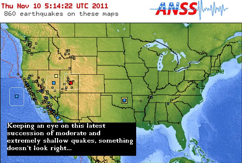
reply to post by berkeleygal
Just a hunch,but try to overlay that Image with the way the Yellowstoner Caldera travelled the last few Million (or Billion) Years...I suspect the Crust may be thinner there for obvious Reasons.
Just a hunch,but try to overlay that Image with the way the Yellowstoner Caldera travelled the last few Million (or Billion) Years...I suspect the Crust may be thinner there for obvious Reasons.
reply to post by diamondsmith
I have just posted the latest Google Earth map of the quakes in Volcano Watch.
No these are not volcanic at all they are tectonic, and yes they are aftershocks. If is a well known fact the the quakes in Turkey progress across the region from East to West so yes this will probably move as the stresses have been changed.
Thanks,but I'll stay to my opinion,I think this could be useful very useful,www.justmagic.com...-00009!!
reply to post by diamondsmith
You originally said
Seeing as I agreed, except for saying they are entirely tectonic, what is you opinion that you are sticking to?
If you are saying these are not aftershocks then perhaps you would like to present your evidence for this so we can all be enlightened. You cannot just state they are not aftershocks without having some reasoning behind it.
The evidence from past events points to this being aftershocks, but please let us hear your take on this.
You originally said
you can see that it is not entirely volcanic but tectonic by twisting of the plates at the boundary of the plates,so....that is very ugly if this region can have a domino effect for the entire region!!!
Seeing as I agreed, except for saying they are entirely tectonic, what is you opinion that you are sticking to?
If you are saying these are not aftershocks then perhaps you would like to present your evidence for this so we can all be enlightened. You cannot just state they are not aftershocks without having some reasoning behind it.
The evidence from past events points to this being aftershocks, but please let us hear your take on this.
Some evidenceYa I know you wait for me,no problem I will endure this,
his event has been reviewed by a seismologist.
Magnitude
5.2
Date-Time
Thursday, November 10, 2011 at 17:25:40 UTC
Thursday, November 10, 2011 at 07:25:40 PM at epicenter
Time of Earthquake in other Time Zones
Location
38.430°N, 21.906°E
Depth
6.9 km (4.3 miles)
Region
GREECE
Distances
27 km (16 miles) NE (34°) from Patras, Greece
141 km (88 miles) SSW (198°) from Larisa, Greece
157 km (97 miles) N (353°) from Kalamata, Greece
167 km (104 miles) WNW (287°) from ATHENS, Greece
Location Uncertainty
horizontal +/- 10.8 km (6.7 miles); depth +/- 5.2 km (3.2 miles)
Parameters
NST=227, Nph=230, Dmin=75.7 km, Rmss=0.78 sec, Gp= 79°,
M-type=body wave magnitude (Mb), Version=9
Source
Magnitude: USGS NEIC (WDCS-D)
Location: USGS NEIC (WDCS-D)
Event ID
usc0006pzk,earthquake.usgs.gov...)some water....!
edit on 10-11-2011 by diamondsmith
because: some evidence why
reply to post by diamondsmith
I thinks USGS have overestimated this one a tad
from the National Observatory of Athens
Hellenic Unified Seismological Network (HUSN)Phase Data
GFZ - 4.4mb
EMSC a bit high too at 5.1mb
JMO
I thinks USGS have overestimated this one a tad
from the National Observatory of Athens
2011/11/10 17:25:39(UTC)
Ml=4.6 , Depth 17Km
173Km WNW of Athens
265Km SSW of Thessaloniki
Hellenic Unified Seismological Network (HUSN)Phase Data
GFZ - 4.4mb
EMSC a bit high too at 5.1mb
JMO
edit on 10-11-2011 by muzzy because: (no reason given)
edit on 10-11-2011 by muzzy because: (no reason given)
Tomorrow is Friday hope everyone ok...11.11.2011...nothing will happen...on the Black Friday!!
Magnitude ML 4.6
Region CANARY ISLANDS, SPAIN REGION
Date time 2011-11-11 00:20:14.0 UTC
Location 28.03 N ; 17.96 W
Depth 10 km
Distances 168 km W San cristóbal de la laguna (pop 139,928 ; local time 00:20:14.9 2011-11-11)
69 km S Los llanos de aridane (pop 19,635 ; local time 00:20:14.9 2011-11-11)
52 km S Fuencaliente de la palma (pop 1,894 ; local time 00:20:14.9 2011-11-11)
Source
To all my esteemed comrades in quake discussions:
For the fun of it I have opened up a catch all kind of thread for earthquake predictions- 24 hour window, so we won't have to wait long to find out! Any reason, any quake, that simple. So post em!
www.abovetopsecret.com...
For the fun of it I have opened up a catch all kind of thread for earthquake predictions- 24 hour window, so we won't have to wait long to find out! Any reason, any quake, that simple. So post em!
www.abovetopsecret.com...
Originally posted by berkeleygal
Berkeleygal, I don't know if you ever read my long-winded explanation for how I envision the plates interacting here in the states?
Here is what I said on another thread a bit ago. I REALLY think it applies (in my mind) to your image.
This is my post (in-part) in response to a question my MamaJ:
I have been trying to think of a good analogy for how I picture our continent. Even saying that, I realize my view is still narrow, because I am limiting myself largely to the continental US, vs the North American Continent....but baby steps. Anyways.....I'm struggling to put my thoughts into cohesive words, but I will give it a try (for you!)
Imagine a piece of clay. You know, that nice grey kind that you used in school to make those lopsided cups and ashtrays back when they were still fashionable table pieces. So....take a nice chunk of it and roll it out so it is more or less of even density and a flat oval roughly the shape of the states. Now...imagine taking a knife and scouring a line from top to bottom...a little off-center to the right. Don't go quite all the way through, but a little over half-way. Do the same thing to the left edge (about where the san-andreas would be)
Here is the tricky part. lay it on a table. Hold the right side with your hand, or place something solid up against it so it won't move. Take a ruler (or something similar) and shove it up under the whole left edge of clay...about a 10th of the way in or so, also pushing up. What happens?
Ofcourse..this is a very rough analogy. To make it more accurate you would also pile some more clay on top where the mountain ranges are, you would draw several thousand more 'cracks' to represent the other known major faults. Then there are areas of greater and less depth, making the surface more vulnerable to 'giving'....etc. I mean, you could get really intricate, but my main point here is to keep to the basics and greatest forces at work.
When I think of the stress placed on the North American Continent by the Pacific Plate, it's got to be great. Enough to form the Cascades. I'm sorry, but that doesn't happen without having an affect on the rest of the landmass. I don't care if there are mountain ranges, rivers, etc. in-between. What do you think caused those mountain ranges, if not from Glaciers? Plate tectonics, volcanics.
So this is what I am thinking when I try to take in the possible scenario of these odd quakes being connected. Going back to my analogy, what would happen to the New madrid when enough force was placed on the landmass to the West of it? When you have something solid, with a weakened area...well, that area of weakness is going to give. Now...with these quakes we are seeing, if you were to abscribe to this theory, you would have to understand that these could be evidence of small amounts of energy being displaced and transfered. Our continent is riddled with faults, all results of said stress. Why is it so far-fetched to then think that the quakes on the East Coast, could be indicators of stress being placed on the West Coast? And that perhaps the greates area of weakness (other than the San Andreas) is the New Madrid?
I also think it possible that the San Andreas is a result of the fracturing of the plate caused by the Cascadian Subduction zone (if it extends all the way South). Now imagine that the NMZ is ALSO a subduction zone (I know...several groans). Apply that to the map you made above. Imagine the 'cracks' extending out from that subduction zone. Just try and imagine all those forces at work and the transfer of energy. Now look at the moderate, shallow quakes you have circled.
Just sayin.
new topics
-
Has Tesla manipulated data logs to cover up auto pilot crash?
Automotive Discussion: 15 minutes ago -
whistleblower Captain Bill Uhouse on the Kingman UFO recovery
Aliens and UFOs: 5 hours ago -
1980s Arcade
General Chit Chat: 7 hours ago -
Deadpool and Wolverine
Movies: 8 hours ago -
Teenager makes chess history becoming the youngest challenger for the world championship crown
Other Current Events: 9 hours ago -
CIA botched its handling of sexual assault allegations, House intel report says
Breaking Alternative News: 10 hours ago
top topics
-
Lawsuit Seeks to ‘Ban the Jab’ in Florida
Diseases and Pandemics: 12 hours ago, 20 flags -
Starburst galaxy M82 - Webb Vs Hubble
Space Exploration: 14 hours ago, 13 flags -
The Superstition of Full Moons Filling Hospitals Turns Out To Be True!
Medical Issues & Conspiracies: 16 hours ago, 8 flags -
CIA botched its handling of sexual assault allegations, House intel report says
Breaking Alternative News: 10 hours ago, 8 flags -
15 Unhealthiest Sodas On The Market
Health & Wellness: 14 hours ago, 6 flags -
whistleblower Captain Bill Uhouse on the Kingman UFO recovery
Aliens and UFOs: 5 hours ago, 6 flags -
1980s Arcade
General Chit Chat: 7 hours ago, 4 flags -
Deadpool and Wolverine
Movies: 8 hours ago, 3 flags -
Teenager makes chess history becoming the youngest challenger for the world championship crown
Other Current Events: 9 hours ago, 3 flags -
Has Tesla manipulated data logs to cover up auto pilot crash?
Automotive Discussion: 15 minutes ago, 0 flags
active topics
-
"We're All Hamas" Heard at Columbia University Protests
Social Issues and Civil Unrest • 199 • : FlyersFan -
It takes One to Be; Two to Tango; Three to Create.
Philosophy and Metaphysics • 7 • : Terpene -
Take it to the Media when you protest.. Don't let them ignore you!
Education and Media • 4 • : SchrodingersRat -
They Killed Dr. Who for Good
Rant • 62 • : FlyersFan -
Has Tesla manipulated data logs to cover up auto pilot crash?
Automotive Discussion • 0 • : Cavemannick -
Lawsuit Seeks to ‘Ban the Jab’ in Florida
Diseases and Pandemics • 22 • : Disgusted123 -
Definitive 9.11 Pentagon EVIDENCE.
9/11 Conspiracies • 421 • : Lazy88 -
1980s Arcade
General Chit Chat • 8 • : F2d5thCavv2 -
What is a dream
The Gray Area • 27 • : wrayth -
Europe declares war on Russia?
World War Three • 61 • : F2d5thCavv2