It looks like you're using an Ad Blocker.
Please white-list or disable AboveTopSecret.com in your ad-blocking tool.
Thank you.
Some features of ATS will be disabled while you continue to use an ad-blocker.

The global alignment of ancient temples
page: 5share:
a reply to: ttobban
I wish I could love your comment. I was about to reply with the same thing, ley lines.
I have quite a few books on the Earth's grid lines and ancient sites and it is amazing! How did they know this back then? Man was definitely smarter than we give them credit for, or smarter than they want us to give them credit for.
It's all about frequency, energy and vibrations. It balances the planet and right now we are off balance.
a reply to: anonentity
Exactly! Boom! and it's this (and many other things) that fry my small prune of a brain.
Exactly! Boom! and it's this (and many other things) that fry my small prune of a brain.
a reply to: mblahnikluver
Thanks, I am fascinated by this subject and the gaps of information between then ad modern day.
What I chalk the disconnect to? I feel that the Pineal Gland had stronger influence and power to the lives of ancient human than it does to modern man. There's many bandwidths of frequency that are omitted in the signaling synapses as the Pineal Gland became calcified and diminished in functional power reception of unknown frequencies.
When people try to debunk these theories, it only grounds my beliefs further to my observations about it all. The limits of frequency reception leads to just that... limits. If a person doesn't know that they had a higher reach of reception on frequencies that may explain why the grid is something that most people just feel and know is there as compared to just walking around it all oblivious to any possible links, then it just makes me learn that ancient human had a better concept of these things than modern man EVER could.
Debunking the grid myth is essentially like personally conveying that one suffers from more frequency reception issues than those who expand on the possible links of the grid. I am just as happy to be wrong, but I refuse to let my mind throw in the towel on the chance to expand frequency reception and possible Pineal Gland function increase.
a reply to: ttobban
Dude, have you seen this post??
www.abovetopsecret.com...
Named.......4500 yr old Metal Work
Posted by theatreboy, the post is about 4500 yr old Metal Work, but more importantly the post is about the ancient Greeks and the fact they carved out the entire surface of a naturally pyramid-shaped promontory on the Greek island of Keros, covered it with 1,000 tonnes of specially imported gleaming white stone.
Similarities ..............Ahem
a reply to: CaptainBeno
Thanks for the link... that's a good read and I enjoyed it a lot. I even added a question for why a Greek statue using a laptop computer being relevant.
They are constantly unearthing pyramids, with a lot of them being kept on the hush hush by governments and what not. They just keep being unearthed. There's a big one in Bosnia that blew me away, and even one found high up in the mountains in the middle of a rain forest in South America. Antarctica has them... supposedly, and they are being found in such volumes partially due to the knowledge of the grid. People are just marking these points on the globe, and they start digging... often hitting a jackpot... at a higher rate than random diggers anyway.
www.smithsonianmag.com...
originally posted by: ttobban
a reply to: Byrd
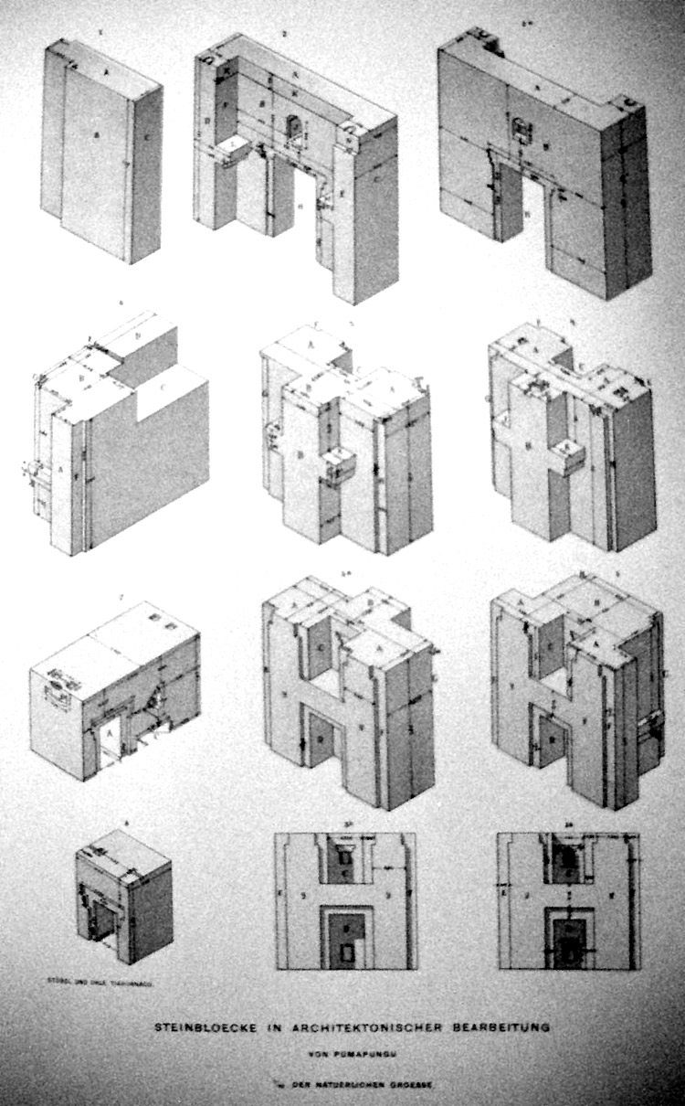
Sorry, the H blocks were put as a reference to cutting technology, and weren't related to the alignments. I'm quite good at running points together that aren't always on the OP topic.
S'okay. I've been known to paste the wrong link, myself. Ah, the hazards of the Interwebs!
Even as America was set up for modern day, there was clearly specific alignments set along ley lines. Ley line construction in the days of exploration is quite simple, I can agree to that.
But there's no general agreement as to how to find ley lines. Dowsing gives different answers, and using preexisting structures and saying they connect to ley lines is rather backwards if you think about it.
But, we were taught these ancient civilizations didn't know each other.
Provably true. When civilizations interact, they share things including food, trade goods, and language and technology - in the same time frame. So when the Middle East gets bronze, Egypt got it as well. A more trivial example is that the ancient Egyptians came up with the notion of the sphinx and the gryphon... and that the nearby cultures (including Greece) borrowed them... along with technology, trade, artifacts from other nations, language exchange, food, transportation and so forth.
I just find it to be a lesser random event that these cultures so unattached were making the same kind of structures with the gaps between the rocks fit together being measured in microns.
The fit isn't that good. Seriously. If it was that good, you couldn't tell where one stone started and the next began.
I highly doubt that a stick or marker that expands the oceans to keep all those significant temples is something that's so easily achieved without GPS of some sorts.
Sunrise is from the same direction all over the planet... and at the same angle for each latitude. Solstice Equinox sunrise direction will be the same no matter where you are. If a Native American tribesman set up a solstice marker in 2020 BC and a Bushman set up a solstice marker in 2020 BC, they would show the exact same alignment although their cultures never interacted.
What sticks were used to factor Easter island into a straight hemisphere from Giza? Did they even have compasses then? I get it... hire Mason & Dixon to measure a few sticks together... pretty simple. But, when's the last time you seen surveyors using sticks to go straight across oceans?
Easter Island is at -27.129081, -109.364261. Giza is at 30.003937, 31.179878. There's no match there in latitude or longitude. As to "straight hemisphere", you can connect any two points on a sphere with a "great circle." That's just a property of globes.
a reply to: Byrd
Oh, I meant to post that H block piece in this thread. What I meant is that I may not be so easily understood, and that the H block addition was in reference to cutting technologies of such precise measure being done across cultures that supposedly didn't know each other. How many things of similarity among these cultures do we have to relate before the lay line structure is recognized. The way I see it, the fact the cuts as so precise in universal fashion, that they all built pyramids universally, they all had equinox interface technology universally is what made modern man even look to the possibility of ley lines... the mere fact that they line up is just an added bonus to links and similarities. The word 'NO' just doesn't provide any analysis to debunk otherwise.
Agreeing on where to find ley lines gets halted at debate... when one side argues they don't exist, and the other side researches them further. Again, we are debating the space of limits here... where the points lining up aren't even being recognized as credible. How is anyone going to draw lines to someone that is not learning that they do in fact line up? If them lining up by design is not possible in ones mind, how can another create the connections they may see?
The fit is that good, and how it got that way is up for debate too. Personally, I think liquifying rock was a way to achieve it, where molding molten stone onto a cold base underneath would create a bond and seem. That's a subject for another time and place though.
I can agree on your thoughts on land measurement, but accuracy's should sway some once the oceans get traveled upon... of which the Earth is 70%. Their guess work was done with sea legs that means, and there's nothing to verify accuracy until GPS came into the picture. Water is the breakdown of the stick measuring hypothesis I feel.
originally posted by: ttobban
a reply to: Byrd
Oh, I meant to post that H block piece in this thread. What I meant is that I may not be so easily understood, and that the H block addition was in reference to cutting technologies of such precise measure being done across cultures that supposedly didn't know each other.
...and are separated by thousands of years in time. It's an interesting solution but not a unique solution... just as we use nails or nail equivalents to tack boards together.
How many things of similarity among these cultures do we have to relate before the lay line structure is recognized.
First you have to document that they knew what a ley line is and that it actually represents something that you can measure (like magnetism. You can measure it whether you believe in it or not and people using the same tools get the same results, even when they don't know what will happen beforehand.) The problem with "ley lines" is that no two people agree on what they are or what tools would allow a nonbeliever to accurately find them.
The way I see it, the fact the cuts as so precise in universal fashion, that they all built pyramids universally, they all had equinox interface technology universally is what made modern man even look to the possibility of ley lines... the mere fact that they line up is just an added bonus to links and similarities.
What about other cultures and civilizations that had beautifully done stonework... but didn't build pyramids? Like the fabulous city of Petra, the Hagia Sophia in Istanbul (which was built about the same time as Puma Punku) or Petra (built about the same time as the earliest Maya pyramids) or the Taj Mahal (built at the same time as the last of the Aztec pyramids)? You point in amazement to the pyramids... but what about these other monumental structures with finer stonework built at the same time in places with no pyramids?
Agreeing on where to find ley lines gets halted at debate... when one side argues they don't exist, and the other side researches them further. Again, we are debating the space of limits here... where the points lining up aren't even being recognized as credible. How is anyone going to draw lines to someone that is not learning that they do in fact line up? If them lining up by design is not possible in ones mind, how can another create the connections they may see?
Exactly. And the first (ever) mention of Ley Lines was in 1921. It's not exactly ancient knowledge.
I can agree on your thoughts on land measurement, but accuracy's should sway some once the oceans get traveled upon... of which the Earth is 70%.
Sunlight is a global phenomenon. If you make something in Turkey line up with the sunrise on March 3rd (a date pulled out of my hat) and make something in Texas eight years later (or eighty years before) that lines up with the sunrise on March 3rd, the two structures will line up because they're lined up on the light of the sun. You can put any number of oceans or mountains between them and it won't matter. Sunlight will still fall the exact same way.
Their guess work was done with sea legs that means, and there's nothing to verify accuracy until GPS came into the picture. Water is the breakdown of the stick measuring hypothesis I feel.
They only used sticks and cords for fairly short surveying areas (miles rather than hundreds of miles.) Early maps were poor references; they get better about the time of the Roman empire with its need to move armies and measure military things.
a reply to: Byrd
Go back to 1:11 in the OP's video... Petra is on the damn ley line shown to start the thread... Petra is on the ley line equator for Christ sakes.
Let's just face it, we keep on talking in circles here. I get what you're trying to say, and it just doesn't jive with me. It's apparent that the same occurrences are happening on your end and that what I am saying just isn't the cup of tea preferred.
In the end, I never said humans aligned these things... because I feel they had help and it was communicated by way of expanded Pineal Gland function.
I can't do anything to sway the thoughts of those that are trying to define something that may be metaphysical to be a purely physical construct.
All the math and sequential patterns are all the proof I need to know ley lines exist. Math is the only true language... all verbiage is just opinions... that goes for all of us. So, all I see here is a grid that math verifies and that there's the other side of the equation that may be ignoring math to benefit the emotions of opinion.
I wear the Flower of Life around my neck like others wear crosses. I trust math, and use words for entertainment purposes. Math has been proposed as an argument for ley lines. Where is the math that debunks ley lines?
All cells and biological life function on a system of leylines. There might not be schematics for it all, but it surely operates by way of the golden
ratio.
Go to the other side of the scale... where planets dance in perfect patterns and ratios in a sea of empty space. Whether we scale the distance of Earth to the Moon and how the Sun and Earth's scaling matches up perfectly when comparing the distances... it just always finds ways of lining up. Look at the dance of Earth around Venus from a topical view... it draws a flower pedal.
The moral of the story here is that the vector points of energy are the star of the show, and whatever humans built whatever on top was following the golden ratio as well. The physical entities discussed are irrelevant to the points that these things reside on energy vector points, where energy transfer is not of the same varieties in areas not on vector points of energy.
Because these vector points of energy are a foreign concept or priority in learning to some the only chance to disect the topic is to work with what can be seen and hope the foreign concepts stick some. If that side of the debate would work from the universal laws of vector mathematics they may find that what was lined up and built by ancients is really on the low end spectrum of paying homage to these universal laws.
The ley lines need to exist for man to even build a building. Hell, the ocean tides and life wouldn't exist if ley lines weren't in place to allow for the perfect brews to create life on Earth.
All biological life is built on the Flower of Life mathematics... if it has a heartbeat, it was built off the Flower of Life. The 5 plutonic solids compose the building blocks for every single element on the periodic table, which is measured by way of Metatrons Cube.
If the debate isn't looked at from a vector mathematics standpoint and moving towards the physical ones, it will always remain a 'chicken/egg' debate. Isn't it kind of silly to indicate that a basic foundation of all life in ley lines and vector energy was not invented or recognized until 1921? Ley lines are the DNA of the universe...
originally posted by: Byrd
What sticks were used to factor Easter island into a straight hemisphere from Giza? Did they even have compasses then? I get it... hire Mason & Dixon to measure a few sticks together... pretty simple. But, when's the last time you seen surveyors using sticks to go straight across oceans?
Easter Island is at -27.129081, -109.364261. Giza is at 30.003937, 31.179878. There's no match there in latitude or longitude. As to "straight hemisphere", you can connect any two points on a sphere with a "great circle." That's just a property of globes.
How very mathematical of you.
Harte
edit on 1/19/2018 by Harte because: of the wonderful things he does!
originally posted by: mblahnikluver
a reply to: ttobban
I wish I could love your comment. I was about to reply with the same thing, ley lines.
I have quite a few books on the Earth's grid lines and ancient sites and it is amazing! How did they know this back then? Man was definitely smarter than we give them credit for, or smarter than they want us to give them credit for.
It's all about frequency, energy and vibrations. It balances the planet and right now we are off balance.
My guess is that "they knew that back then" because somebody else informed them about that. They received such knowledge from other sentient beings.
a reply to: Salander
I think the Dragon /Ley/Telluric lines could be key to all this placement. Where it gets confusing is when someone goes out with a Dowsing rod and does their own subjective survey, then another does the same and gets a totally different placement. Remembering that two Gold type wizard/witches hats were dug up in Europe with the 18.6 year Moon cycle on them seems to suggest that perhaps, leys are activated by the moons ground position as it stresses the quartz in the Earths Quartz reefs.
New Grange has a nice quartz wall, but the wall used to be the pavement, and any people walking on it would see tiny flashes of light as they stepped along, in America Shaman rattles were filled with this rock and as they were shaken they flashed. So no wonder this Silica Oxygen stone was called "Spirit stone" and the pink Granite in the Kings Chamber of the G.P.contains a lot of it. The fact that if an electrical charge goes through it will flash with light. Same as the blue stones on Stonehenge. Ill post this and get a demonstration vid
edit on 19-1-2018 by
anonentity because: adding
a reply to: CaptainBeno
Interesting I made a topic about this in 2016.
www.abovetopsecret.com...
It it interesting. I only saw disinformation users jump on my post however.
Interesting I made a topic about this in 2016.
www.abovetopsecret.com...
It it interesting. I only saw disinformation users jump on my post however.
edit on 19-1-2018 by BlackProject because: (no reason
given)
originally posted by: BlackProject
a reply to: CaptainBeno
Interesting I made a topic about this in 2016.
www.abovetopsecret.com...
It it interesting. I only saw disinformation users jump on my post however.
I was in that thread, and the only disinformation was posted by you.
Harte
The odds? Astronomical. Ha! In one of those coincidence thingys I just posted a link to another thread about
Chaco Canyon, and how it lines up with other sites creating the
constellation Orion on the ground in Arizona and New Mexico. Chaco Canyon itself is Sirius in this layout!
It seems that many different societies were looking up at the stars. Guess which one is the easiest to detect? Well, there are several (Cygnus and Ursa Major, come to mind) but it seems Orion holds the winning bet.
When you are lining up buildings with stars in a particular constellation, even with precession, it is not so surprising that they lie upon a major axis. Notice how some sites lie at the edge while others are smack dab in the middle? It would appear that some cultures were well aware of the precession of the equinoxes and built with that in mind. Others built for the moment.
Remember the old alchemical saying, "As above, so below"!
a reply to: IgnoranceIsntBlisss
Ancient Hindus were known for it a CASTE Society
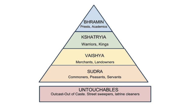
Mans Civilization is more Like a Social Insect Society then A Apes Society

Man Has More in Common with a Insect ( Wasps Bees Ants ) for Survival Then a Ape..
We have More Caste ( Natural Selection of Ability Occupation Militant /White/ Blue Collar ) like a Insect then as a Ape
yet we are 98 Percent of the Great APE's yet we live in a pyramid Structured ( Hive Society )
perhaps we had CLOSE.... to a One World Civilization Society in 3 belts Arctic Circle , Mediterranean great lakes Circle, Equator Circle , does seem s Far fetch , Mans Knowledge ( history is lost ) 90 percent of it MAN has been on the Planet ( homo Sapiens ) for 250,000 years but only Written Language history close too 10,000 and Pictorial History 40,000 years plus , So what was Modern Man doing for 210,000 years ? thats the Big Question, a Game Change some where ...
Lay Lines are Everywhere, around the World unfortunately
they have been removed ore moved or Destroyed
and what about Similarity's of Civilizations between the Old World and the New. ?
Supposedly Ancient indigenous Peruvians Made these
Ancient Hindus were known for it a CASTE Society
Mans Civilization is more Like a Social Insect Society then A Apes Society
Man Has More in Common with a Insect ( Wasps Bees Ants ) for Survival Then a Ape..
We have More Caste ( Natural Selection of Ability Occupation Militant /White/ Blue Collar ) like a Insect then as a Ape
yet we are 98 Percent of the Great APE's yet we live in a pyramid Structured ( Hive Society )
perhaps we had CLOSE.... to a One World Civilization Society in 3 belts Arctic Circle , Mediterranean great lakes Circle, Equator Circle , does seem s Far fetch , Mans Knowledge ( history is lost ) 90 percent of it MAN has been on the Planet ( homo Sapiens ) for 250,000 years but only Written Language history close too 10,000 and Pictorial History 40,000 years plus , So what was Modern Man doing for 210,000 years ? thats the Big Question, a Game Change some where ...
Lay Lines are Everywhere, around the World unfortunately
they have been removed ore moved or Destroyed
and what about Similarity's of Civilizations between the Old World and the New. ?
Supposedly Ancient indigenous Peruvians Made these
edit on 52018FridayfAmerica/Chicago118 by Wolfenz because: (no reason given)
yes, did someone already post....on utube there's some home boy pointing out if one starts at the big pyramid as the mean time line....instead of
London's Grenwich village line....common math functions locate em all....to the thousandth.....longitude and lattitude around the globe
originally posted by: ignorant_ape
a reply to: CaptainBeno
this APPEARS to be :
draw a VERY broad line around the globe - starting at one ancient site and ending at a second - then cherry pick all the other ancient sites that the line crosses
and simply ignore all sites that lay outside the " line "
what is the criteria ????
I would be interested to know just how broad this line would have to be. If it was 2 miles or less wide, that would be astounding.
originally posted by: GBP/JPY
yes, did someone already post....on utube there's some home boy pointing out if one starts at the big pyramid as the mean time line....instead of London's Grenwich village line....common math functions locate em all....to the thousandth.....longitude and lattitude around the globe
Ah, so, not a very broad line after all... (see my post above)
new topics
-
Putin, Russia and the Great Architects of the Universe
ATS Skunk Works: 37 minutes ago -
A Warning to America: 25 Ways the US is Being Destroyed
New World Order: 5 hours ago -
President BIDEN's FBI Raided Donald Trump's Florida Home for OBAMA-NORTH KOREA Documents.
Political Conspiracies: 10 hours ago
top topics
-
President BIDEN's FBI Raided Donald Trump's Florida Home for OBAMA-NORTH KOREA Documents.
Political Conspiracies: 10 hours ago, 28 flags -
A Warning to America: 25 Ways the US is Being Destroyed
New World Order: 5 hours ago, 10 flags -
Gaza Terrorists Attack US Humanitarian Pier During Construction
Middle East Issues: 17 hours ago, 8 flags -
Las Vegas UFO Spotting Teen Traumatized by Demon Creature in Backyard
Aliens and UFOs: 15 hours ago, 6 flags -
2024 Pigeon Forge Rod Run - On the Strip (Video made for you)
Automotive Discussion: 16 hours ago, 4 flags -
Is AI Better Than the Hollywood Elite?
Movies: 12 hours ago, 3 flags -
Maestro Benedetto
Literature: 12 hours ago, 1 flags -
Putin, Russia and the Great Architects of the Universe
ATS Skunk Works: 37 minutes ago, 1 flags
active topics
-
Putin, Russia and the Great Architects of the Universe
ATS Skunk Works • 7 • : RussianTroll -
"We're All Hamas" Heard at Columbia University Protests
Social Issues and Civil Unrest • 286 • : FlyersFan -
A Warning to America: 25 Ways the US is Being Destroyed
New World Order • 9 • : Lazy88 -
President BIDEN's FBI Raided Donald Trump's Florida Home for OBAMA-NORTH KOREA Documents.
Political Conspiracies • 21 • : CriticalStinker -
SETI chief says US has no evidence for alien technology. 'And we never have'
Aliens and UFOs • 75 • : Hecate666 -
Las Vegas UFO Spotting Teen Traumatized by Demon Creature in Backyard
Aliens and UFOs • 13 • : FlyersFan -
Mood Music Part VI
Music • 3105 • : BrucellaOrchitis -
The Acronym Game .. Pt.3
General Chit Chat • 7752 • : bally001 -
Is AI Better Than the Hollywood Elite?
Movies • 18 • : Hecate666 -
Hate makes for strange bedfellows
US Political Madness • 49 • : network dude