It looks like you're using an Ad Blocker.
Please white-list or disable AboveTopSecret.com in your ad-blocking tool.
Thank you.
Some features of ATS will be disabled while you continue to use an ad-blocker.

Quake Watch 2015
page: 32share:
a reply to: muzzy
USGS has it at a 7.0
M7.0 - Southern Mid-Atlantic Ridge
Time
2015-06-17 12:51:33 (UTC)
Nearby Cities
494km (307mi) WNW of Edinburgh of the Seven Seas, Saint Helena
2750km (1709mi) SE of Arraial do Cabo, Brazil
2752km (1710mi) SE of Armacao de Buzios, Brazil
2755km (1712mi) SE of Cabo Frio, Brazil
3513km (2183mi) ESE of Montevideo, Uruguay
earthquake.usgs.gov...
a reply to: Darkblade71
M6.8= 239 KT (Kilotons of energy released)
M6.9= 338 KT
M7.0= 477 KT
big difference eh.
I'll give it 24hrs before I add it to the 2015 M6.5+ map and list, see what IRIS finally posts it as.
currently @ 6.1mb, they are using GCMT's reading of 6.9Mw for the Moment Tensor
ds.iris.edu...
M6.8= 239 KT (Kilotons of energy released)
M6.9= 338 KT
M7.0= 477 KT
big difference eh.
I'll give it 24hrs before I add it to the 2015 M6.5+ map and list, see what IRIS finally posts it as.
currently @ 6.1mb, they are using GCMT's reading of 6.9Mw for the Moment Tensor
ds.iris.edu...
edit on 0600000016716715 by muzzy because: (no reason given)
M4.2 - 21km W of Perry, Oklahoma
(upgraded from a 4.1)
Time
2015-06-17 19:17:08 (UTC)
Nearby Cities
21km (13mi) W of Perry, Oklahoma
34km (21mi) ESE of Enid, Oklahoma
45km (28mi) WNW of Stillwater, Oklahoma
46km (29mi) N of Guthrie, Oklahoma
91km (57mi) N of Oklahoma City, Oklahoma
earthquake.usgs.gov...
(upgraded from a 4.1)
Time
2015-06-17 19:17:08 (UTC)
Nearby Cities
21km (13mi) W of Perry, Oklahoma
34km (21mi) ESE of Enid, Oklahoma
45km (28mi) WNW of Stillwater, Oklahoma
46km (29mi) N of Guthrie, Oklahoma
91km (57mi) N of Oklahoma City, Oklahoma
earthquake.usgs.gov...
edit on 17-6-2015 by Darkblade71 because: (no reason
given)
edit on 17-6-2015 by Darkblade71 because: (no reason given)
a reply to: muzzy
I see the USGS reading is 7.0 MO on IRIS
that's not a regular type of magnitude they use
wonder whats up with that? and why not post it in Mw?
Why did IRIS use the GCMT Mw and not USGS (NIEC)
here is where I got that info.
ds.iris.edu...
case of communication breakdown?
this is why I dropped the baseline on the M7+ project and renamed it, this one is right on the tipping point, likely USGS will drop it in 7-30 day lists.
LDEO has 6.7Ms
GeoAustralia have;
Mwp: 6.8 (Preferred)
Mb: 6.39
Ms: 7.1
Russians
6.8Ms, 6.3mb
edit on 0600000016816815 by muzzy because: (no reason given)
Magnitude M 6.1
Region NORTH PACIFIC OCEAN
Date time 2015-06-19 14:51:17.1 UTC
Location 24.70 N ; 171.54 E
Depth 10 km
Distances 1949 km N of Majuro, Marshall Islands / pop: 25,400 / local time: 02:51:17.1 2015-06-20
2591 km N of Tarawa, Kiribati / pop: 40,311 / local time: 02:51:17.1 2015-06-20
2890 km NE of Saipan, Northern Mariana Islands / pop: 48,220 / local time: 00:51:17.1 2015-06-20
EMSC
a reply to: whatnext21
Not sure GEO also has it listed.
edit on 19-6-2015 by lurksoften
because: (no reason given)
a reply to: lurksoften
How does USGS totally ignore this one a 6.1 in northern pacific, did it happen or not?
How does USGS totally ignore this one a 6.1 in northern pacific, did it happen or not?
a reply to: lurksoften
well that last one poofed lets see about this one...
EMSC
USGS 6.4
well that last one poofed lets see about this one...
Magnitude Mw 6.4
Region OFFSHORE BIO-BIO, CHILE
Date time 2015-06-20 02:10:06.4 UTC
Location 36.33 S ; 73.82 W
Depth 10 km
Distances 414 km SW of Santiago, Chile / pop: 4,837,295 / local time: 23:10:07.5 2015-06-19
62 km NW of Concepción, Chile / pop: 215,413 / local time: 23:10:07.5 2015-06-19
49 km NW of Talcahuano, Chile / pop: 252,968 / local time: 23:10:07.5 2015-06-19
EMSC
USGS 6.4
edit on 19-6-2015 by lurksoften because: (no
reason given)
a reply to: lurksoften
I've been at work all night giggling. Thinking of that missing earthquake, knowing it had been downgraded.
I crack myself up sometimes. I went back and forth with that quake twice before I put the two together. LOL!!
I've been at work all night giggling. Thinking of that missing earthquake, knowing it had been downgraded.
I crack myself up sometimes. I went back and forth with that quake twice before I put the two together. LOL!!
a reply to: lurksoften
Interesting, it wasn't even a mistake by the providing networks to EMSC
as can be seen on the following list
www.emsc-csem.org...
usually if it gets withdrawn, it still shows on the list, from an unreliable sorce usually, like BUC (Bulgaria)
but there is nothing at all at that time.
Interesting, it wasn't even a mistake by the providing networks to EMSC
as can be seen on the following list
www.emsc-csem.org...
usually if it gets withdrawn, it still shows on the list, from an unreliable sorce usually, like BUC (Bulgaria)
but there is nothing at all at that time.
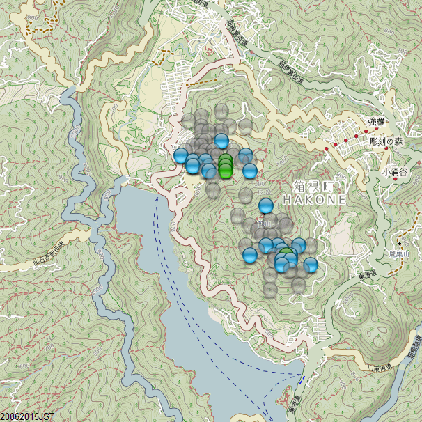
Update on Hakone, Honshu, Japan.
I stopped making the maps after the 8th when there were only 3 micro micro quakes (~M0.0). There have only been one or two quakes a day since, 4x M1's on the 15th.
Up till 2 days ago............ 20/06/2015JST
mag~1= 75
mag1= 19
mag2= 4
total= 98
Not much ER though, only 0.442TTNT
Two areas of activity,
around the Hotel Green Plaza
and under the main cone
Since our quake watchers are apparently asleep I thought I should post there was a 6.5 that I believe was downgraded to a 5.9 in the Ndoi island
region of Fiji.
Sorry I have no idea how to post that in the proper quake watch format, but it has been nearly half an hour now......
Sorry I have no idea how to post that in the proper quake watch format, but it has been nearly half an hour now......
www.9news.com.au...
earthquaketrack.com...
edit on 21-6-2015 by GoShredAK because: Really am trying to help
a reply to: GoShredAK
not asleep just was working.
USGS
EMSC still showin 6.5
GEO 5.9
not asleep just was working.
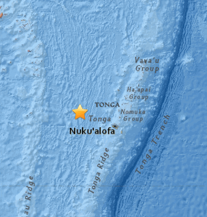
M6.0 - 42km ENE of Ndoi Island, Fiji
20.457°S 178.351°W depth=561.4 km (348.8 mi)
Time
2015-06-21 21:28:16 (UTC)
2015-06-21 16:28:16 (UTC-05:00) in your timezone
Times in other timezones
Nearby Cities
42km (26mi) ENE of Ndoi Island, Fiji
336km (209mi) WNW of Nuku`alofa, Tonga
423km (263mi) SE of Suva, Fiji
507km (315mi) SSE of Lambasa, Fiji
533km (331mi) SE of Nadi, Fiji
USGS
EMSC still showin 6.5
GEO 5.9
a reply to: GoShredAK
9 News link,
Words say Fiji, map shows Tonga
They are not the same islands
There was one to the SW yesterday too. Was 6.0 downgraded to 5.9 today on Geofon
geofon.gfz-potsdam.de...
both deep
9 News link,
Words say Fiji, map shows Tonga
They are not the same islands
There was one to the SW yesterday too. Was 6.0 downgraded to 5.9 today on Geofon
geofon.gfz-potsdam.de...
both deep
edit on 0600000017217215 by muzzy because: (no reason given)
I was wondering this morning how they were getting on at Gubbio, Perugia (Umbria), Italy, there was a long term swarm series going on 2010-2014.
Looks pretty quiet on 20/06/2015
Italy 20/06/2015
click on icon 5 and then Zoom and it will take you to the area.
A question that this process of creating the map raised is;
Is it your preference for the events to be listed by
Date?
or
Magnitude?
Because it is number icons (Bing can't do colours from KMZ) so it can be hard to find the bigger quakes on the map, you have to use the list on the left side and scroll through it.
Actually Bing WILL do colours, like if I take the ISIDe data directly as a KML file and put it on Bing it looks like this (coloured by depth)
Bing Direct KMZ
circles are a bit big though.
I still can't figure Bing out.
If I put MY icons in the CSV file and build a KMZ file, Bing shows them as Numbered Icons
If I don't put any icons in the CSV file, the KMZ comes out with big white circles on Bing.
Looks pretty quiet on 20/06/2015
Italy 20/06/2015
click on icon 5 and then Zoom and it will take you to the area.
A question that this process of creating the map raised is;
Is it your preference for the events to be listed by
Date?
or
Magnitude?
Because it is number icons (Bing can't do colours from KMZ) so it can be hard to find the bigger quakes on the map, you have to use the list on the left side and scroll through it.
edit on 0600000017217215 by muzzy because: (no reason given)
Actually Bing WILL do colours, like if I take the ISIDe data directly as a KML file and put it on Bing it looks like this (coloured by depth)
Bing Direct KMZ
circles are a bit big though.
I still can't figure Bing out.
If I put MY icons in the CSV file and build a KMZ file, Bing shows them as Numbered Icons
If I don't put any icons in the CSV file, the KMZ comes out with big white circles on Bing.
edit on 0600000017217215 by muzzy because: (no
reason given)
My mistake in the poor choice of link earlier in regards to the Fiji EQ
M6.3 - 248km WNW of Chichi-shima, Japan
27.669°N 139.793°E depth=455.9 km (283.3 mi)
Time
2015-06-23 12:18:29 (UTC)
2015-06-23 04:18:29 (UTC-08:00) in your timezone Times in other timezones
Nearby Cities
248km (154mi) WNW of Chichi-shima, Japan
764km (475mi) SSE of Shingu, Japan
780km (485mi) S of Shimoda, Japan
783km (487mi) SSE of Oyama, Japan
edit on 23-6-2015 by GoShredAK because: (no reason given)
a reply to: GoShredAK
Its not your fault 9News put the star marker in the wrong place.
Or more likely, USGS's first location was wrong, I see 9News credit's USGS for the map image.
USGS have been known to be inaccurate on initial locations, then seem to get it sorted out a few days later for the 7 days lists.
Your second link had it correctly marked, on the Lau Ridge
In Fact if you click on the map image on the USGS summary page that lursoften posted, it opens on another bigger map with the star in the correct location
Summary page map image
when clicked shows this Interactive map
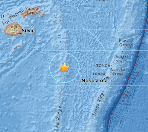
Poor housekeeping at USGS.
This is why I usually wait at least 24 hours before using the data, the other Networks are just as bad, especially with the magnitudes.
I see EMSC have 3 new 6.5+ events listed since the Southern Mid Atlantic Ridge of 17/6/2015
I will add the Chile and South of Fiji ones to my mapping project, and let the latest one (Bonin Is.) sit until they do the magnitude conversions and relocations, USGS have it as M6.3 on the General Summary page and 6.5Mw on the Scientific page.
Its not your fault 9News put the star marker in the wrong place.
Or more likely, USGS's first location was wrong, I see 9News credit's USGS for the map image.
USGS have been known to be inaccurate on initial locations, then seem to get it sorted out a few days later for the 7 days lists.
Your second link had it correctly marked, on the Lau Ridge
edit on 0600000017317315 by muzzy because: (no reason given)
In Fact if you click on the map image on the USGS summary page that lursoften posted, it opens on another bigger map with the star in the correct location
Summary page map image
when clicked shows this Interactive map
Poor housekeeping at USGS.
This is why I usually wait at least 24 hours before using the data, the other Networks are just as bad, especially with the magnitudes.
I see EMSC have 3 new 6.5+ events listed since the Southern Mid Atlantic Ridge of 17/6/2015
I will add the Chile and South of Fiji ones to my mapping project, and let the latest one (Bonin Is.) sit until they do the magnitude conversions and relocations, USGS have it as M6.3 on the General Summary page and 6.5Mw on the Scientific page.
edit on 0600000017317315 by muzzy because: (no reason given)
a reply to: GoShredAK
Still waiting for NIED AQUA to convert to Mw, it should be the next one at the top of the list, maybe it will come on overnight NZST
www.hinet.bosai.go.jp...
but they have this one as 6.9ML on the JMA page www.jma.go.jp...
Still waiting for NIED AQUA to convert to Mw, it should be the next one at the top of the list, maybe it will come on overnight NZST
www.hinet.bosai.go.jp...
but they have this one as 6.9ML on the JMA page www.jma.go.jp...
makes sense now. Thanks for all that
edit on 24-6-2015 by GoShredAK because: (no reason given)
Eketahuna again, at the north end of the 2014 aftershock series (M6.2 of
20/01/2014)
ID: 2015p469063 Network: geonet
Status: reviewed
Date/Time NZST: 24/06/2015 01:17:07
Date/Time UTC: 23/06/2015 13:17:07
Latitude, Longitude: -40.5936, 175.923
Magnitude: 4.15M
Depth: 26.80 km
Energy Released: 25.0472 tonnes of TNT
Location: Pori, Wairarapa (
www.geonet.org.nz...
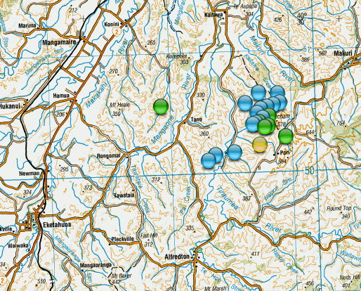
21 aftershocks;
mag1= 15
mag2= 6
Total TTNT= 25.451
nzeq2015.blogspot.co.nz...
ID: 2015p469063 Network: geonet
Status: reviewed
Date/Time NZST: 24/06/2015 01:17:07
Date/Time UTC: 23/06/2015 13:17:07
Latitude, Longitude: -40.5936, 175.923
Magnitude: 4.15M
Depth: 26.80 km
Energy Released: 25.0472 tonnes of TNT
Location: Pori, Wairarapa (
www.geonet.org.nz...
21 aftershocks;
mag1= 15
mag2= 6
Total TTNT= 25.451
nzeq2015.blogspot.co.nz...
new topics
-
Shocking Number of Voters are Open to Committing Election Fraud
US Political Madness: 27 minutes ago -
Gov Kristi Noem Shot and Killed "Less Than Worthless Dog" and a 'Smelly Goat
2024 Elections: 1 hours ago -
Falkville Robot-Man
Aliens and UFOs: 1 hours ago -
James O’Keefe: I have evidence that exposes the CIA, and it’s on camera.
Whistle Blowers and Leaked Documents: 2 hours ago -
Australian PM says the quiet part out loud - "free speech is a threat to democratic dicourse"...?!
New World Order: 2 hours ago -
Ireland VS Globalists
Social Issues and Civil Unrest: 3 hours ago -
Biden "Happy To Debate Trump"
Mainstream News: 3 hours ago -
RAAF airbase in Roswell, New Mexico is on fire
Aliens and UFOs: 4 hours ago -
What is the white pill?
Philosophy and Metaphysics: 5 hours ago -
Blast from the past: ATS Review Podcast, 2006: With All Three Amigos
Member PODcasts: 6 hours ago
top topics
-
A Warning to America: 25 Ways the US is Being Destroyed
New World Order: 13 hours ago, 21 flags -
Biden "Happy To Debate Trump"
Mainstream News: 3 hours ago, 8 flags -
Mike Pinder The Moody Blues R.I.P.
Music: 6 hours ago, 7 flags -
Blast from the past: ATS Review Podcast, 2006: With All Three Amigos
Member PODcasts: 6 hours ago, 7 flags -
What is the white pill?
Philosophy and Metaphysics: 5 hours ago, 5 flags -
James O’Keefe: I have evidence that exposes the CIA, and it’s on camera.
Whistle Blowers and Leaked Documents: 2 hours ago, 5 flags -
Australian PM says the quiet part out loud - "free speech is a threat to democratic dicourse"...?!
New World Order: 2 hours ago, 5 flags -
Ireland VS Globalists
Social Issues and Civil Unrest: 3 hours ago, 4 flags -
RAAF airbase in Roswell, New Mexico is on fire
Aliens and UFOs: 4 hours ago, 4 flags -
Putin, Russia and the Great Architects of the Universe
ATS Skunk Works: 9 hours ago, 3 flags
active topics
-
Gov Kristi Noem Shot and Killed "Less Than Worthless Dog" and a 'Smelly Goat
2024 Elections • 24 • : TimBurr -
Falkville Robot-Man
Aliens and UFOs • 4 • : Kurokage -
The functionality of boldening and italics is clunky and no post char limit warning?
ATS Freshman's Forum • 13 • : JonnyC555 -
Candidate TRUMP Now Has Crazy Judge JUAN MERCHAN After Him - The Stormy Daniels Hush-Money Case.
Political Conspiracies • 805 • : Vermilion -
Shocking Number of Voters are Open to Committing Election Fraud
US Political Madness • 1 • : YourFaceAgain -
-@TH3WH17ERABB17- -Q- ---TIME TO SHOW THE WORLD--- -Part- --44--
Dissecting Disinformation • 700 • : Thoughtful3 -
Putin, Russia and the Great Architects of the Universe
ATS Skunk Works • 26 • : RussianTroll -
Re-election Tactic - JOE BIDEN Hints He May Put Books in the Homes of Black People.
2024 Elections • 30 • : WeMustCare -
Australian PM says the quiet part out loud - "free speech is a threat to democratic dicourse"...?!
New World Order • 3 • : Athetos -
Biden "Happy To Debate Trump"
Mainstream News • 35 • : WeMustCare