It looks like you're using an Ad Blocker.
Please white-list or disable AboveTopSecret.com in your ad-blocking tool.
Thank you.
Some features of ATS will be disabled while you continue to use an ad-blocker.

Quake Watch 2015
page: 31share:
a reply to: muzzy
i don't know if anyone googled it but here is the skinny on the "black eggs"
www.atlasobscura.com...
Who would have thought eh.
i can't wait to win the Lottery and do the circuit, El Hierro, Hakone, Iceland ........... heaps of other places
After a month looking at the Hakone map every day, I almost know it like my own neighborhood.
Too bad about the tourist's though, I bet you have to queue for your black eggs, I hate queue's.
i don't know if anyone googled it but here is the skinny on the "black eggs"
Owakudani, meaning the Great Boiling Valley, is located in the mountain town of Hakone. One can take an aerial tram up to the hot springs, or walk up the 1 km path. On clear days either route delivers spectacular views of the ominous Mt. Fuji.
Once the springs are reached, kuro-tamago, or black eggs, can be purchased five at a time. The eggs are ordinary chicken eggs but the shell turns black due to being boiled in the hot sulfur spring. Local tradition holds that for each black egg eaten, seven years is added to one's life. However, some say that eating more than two is not recommended.
The valley is sometimes referred to as "The Death Valley" by locals. Some 3000 years ago Mount Hakone erupted leaving the hot spring filled crater. All along the path to the egg vendor are active sulfuric geysers, which can be hazardous at times. The area is prone to landslides due to the constant volcanic activity. In potentially unsafe conditions, the walkways to the egg boiling springs may be closed.
www.atlasobscura.com...
Who would have thought eh.
i can't wait to win the Lottery and do the circuit, El Hierro, Hakone, Iceland ........... heaps of other places
After a month looking at the Hakone map every day, I almost know it like my own neighborhood.
Too bad about the tourist's though, I bet you have to queue for your black eggs, I hate queue's.
M4.3 - 7km SE of Harper, Kansas
Time
2015-06-05 23:12:41 (UTC)
Nearby Cities
7km (4mi) SE of Harper, Kansas
64km (40mi) WSW of Haysville, Kansas
70km (43mi) WSW of Derby, Kansas
74km (46mi) SW of Wichita, Kansas
200km (124mi) NNW of Oklahoma City, Oklahoma
earthquake.usgs.gov...
Time
2015-06-05 23:12:41 (UTC)
Nearby Cities
7km (4mi) SE of Harper, Kansas
64km (40mi) WSW of Haysville, Kansas
70km (43mi) WSW of Derby, Kansas
74km (46mi) SW of Wichita, Kansas
200km (124mi) NNW of Oklahoma City, Oklahoma
earthquake.usgs.gov...
a reply to: crappiekat
The product may look something like this:
A comparison pie might look like this:
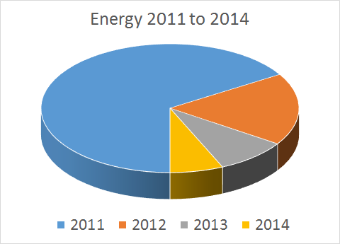
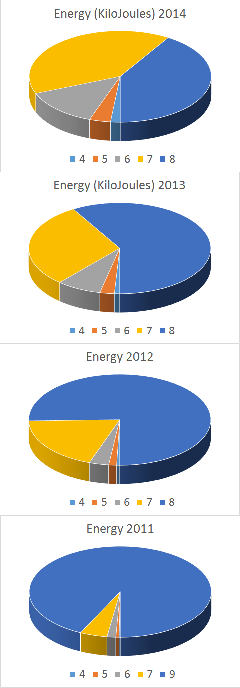
The only problem is that this is HUGELY processor intensive. It has all 4 cores on my computer banging away full throttle for over a minute to produce on of the Weekly Geophysical Report sets so it may kill a smaller PC stone dead so the question is, should I include it anyway?
The product may look something like this:
A comparison pie might look like this:
The only problem is that this is HUGELY processor intensive. It has all 4 cores on my computer banging away full throttle for over a minute to produce on of the Weekly Geophysical Report sets so it may kill a smaller PC stone dead so the question is, should I include it anyway?
a reply to: PuterMan
Those 3D Pies are handy for quick understanding of what went on.
I have found 3D graphing chews up a lot of memory. That is one reason I went back to the flat pie with just slightly rounded edges for an "almost 3D" effect.
I was experimenting with Bar Graphs today (raining again!), an "advance" on the Icelandic style of timeline graph.
The Iceland style uses "error bars" to get the line dropdown from the marker on the graph.
Here I have widened the error bar itself and mucked around with the angle of the fill to get 3D.
Trouble is once I have created the graph the Excel file won't save it because of "errors", "corruption" etc
So if I close it, then reopen it, the graph is not there.
Its a one off thing, create it, screenshot it, then it's gone.
Adding Labels sends my laptop into a spin. I think it is because I am using Excel2010 spreadsheets on a Excel2007 program.
edit on 0600000015715715 by muzzy because: (no reason given)
M6.2 -
64km ENE of Mutsu, Japan
earthquake.usgs.gov...
Time
2015-06-08 06:01:08 (UTC)
2015-06-07 23:01:08 (UTC-07:00) in your timezone
Times in other timezones
Nearby Cities
64km (40mi) ENE of Mutsu, Japan
99km (62mi) NNE of Misawa, Japan
102km (63mi) SSW of Shizunai, Japan
107km (66mi) ESE of Hakodate, Japan
670km (416mi) NNE of Tokyo, Japan
I missed this little guy over in Alabama.
USGS
Source
M3.0 - 15km NW of Eutaw, Alabama
32.938°N 88.004°W depth=6.3 km (3.9 mi)
Time
2015-06-06 18:09:35 (UTC)
2015-06-06 13:09:35 (UTC-05:00) in your timezone
Times in other timezones
Nearby Cities
15km (9mi) NW of Eutaw, Alabama
50km (31mi) SW of Tuscaloosa, Alabama
51km (32mi) SW of Northport, Alabama
73km (45mi) SSE of Columbus, Mississippi
171km (106mi) WNW of Montgomery, Alabama
USGS
GREENE COUNTY - AL - You don't hear this too often in Alabama, but the United States Geographical Survey reports an earthquake in Greene County Saturday afternoon. It happened at 1:09 p.m. near Eutaw.
USGS reports the quake at a magnitude 3.0. According to the USGS site, that means the earthquake can be felt, but rarely causes damage. At that magnitude, indoor object might noticeably shake.
Some people told us on Twitter and Facebook, they felt it all the way in Northport.
Source
edit on 8-6-2015 by lurksoften because: (no reason given)
a reply to: dreamfox1
JMA are saying that was only a 5.5ML,
www.jma.go.jp...
bumped up by the USGS conversion to MW.
earthquake.usgs.gov...
Bit of activity in Hokaiddo too that I missed a few days back, a M5.0, I just noticed the clump of aftershocks.
Lat/Long: 43.492, 144.06
UTC: 03/06/2015 19:34:15
JST: 04/06/2015 04:34:15
Depth: 0
Mag: 5.0 ML
Location: TESHIKAGA REGION
Energy Released: 476.8791 tonnes of TNT
Source: JMA Status: reviewed
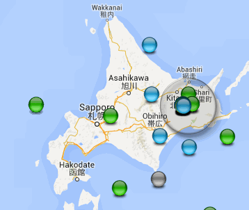
japanquakes.blogspot.co.nz...
JMA are saying that was only a 5.5ML,
www.jma.go.jp...
bumped up by the USGS conversion to MW.
earthquake.usgs.gov...
Bit of activity in Hokaiddo too that I missed a few days back, a M5.0, I just noticed the clump of aftershocks.
Lat/Long: 43.492, 144.06
UTC: 03/06/2015 19:34:15
JST: 04/06/2015 04:34:15
Depth: 0
Mag: 5.0 ML
Location: TESHIKAGA REGION
Energy Released: 476.8791 tonnes of TNT
Source: JMA Status: reviewed
japanquakes.blogspot.co.nz...
a reply to: muzzy
continued at Volcano Watch 2015 .............. new post by muzzy
ha! I forgot ATS did popups now instead of direct links
here is the direct link
continued at Volcano Watch 2015 .............. new post by muzzy
ha! I forgot ATS did popups now instead of direct links
here is the direct link
edit on 0600000015815815 by muzzy because: (no reason given)
Been working on NZ M5+ earthquake pages, replacing the thumbnails on the Home page with Energy Pie Graphs and I have upgraded a few feature events
along the way, specifically 2007 Gisborne, 2009 Dusky Sound, and 2003 Secretary Island major events, replacing the static aftershock images with NZ
Topo Interactive Maps.
I also dragged the details of 2015's major events over from my NZ Daily Blog into the 2015 page.
Seems to work OK, a lot depends on what your ISP loading is like at the time you open the page, for example 2003 has 3,660 icons on the 3rd map, when I posted it I couldn't get it to work properly, half the Icons defaulted to Google Blue icons and one panel of icons wouldn't show at all. Then I tried a couple of hours later and its all there.
I created a couple of new Timeline graphs too.
This Blog is one of my most popular (41,719 visitors), Belgium is the 2nd most popular source of visitors with 12,086, after NZ 24,120, USA only 2,150.
Been going for a while, I started it in 2010.
Disregard the dates of the page posts, I have manipulated those so I can get each year in sequence.
Quite a few more years to upgrade yet, 2013, 2010, 2011 bring in the Canterbury stuff from Wordpress. I did some prior work on the 1990's, have lost the original data, so have to download that again to create the active maps.
on the to-do list;
1995 East Cape 7.0
1994 Arthurs Pass 6.7
1993 Secretary Is. 6.8
1993 Ormond 6.3
1992 Wairau 6.8
1992 Weber 4
1991 Hawks Crag 1,2 & 3
1990 Weber 1,2 & 3
1990 Lake Tennyson 5.8
1989 Fiordland 6.1
1988 Irene River 6.1
1987 Edgecumbe 6.1
1984 Ngatoro Basin Swarm
1968 Inangahua 7.1
and heaps more back to 1840
NZ M5 Mapping Project
I have a feeling its going to be a wet Winter here, been lousy for 2 weeks already, not much work going on out on site.
edit on
0600000016016015 by muzzy because: (no reason given)
After earthquake Mw 6.1 near Antofagasta is amazing to see that seismic zone in 3D!
www.mapsism.com...
What do you think?
Is good?
www.mapsism.com...
What do you think?
Is good?
a reply to: dreamfox1
108 visitors on my japanearthquakes yesterday, must have come looking for this quake.
Good to know it comes up on the search's now.
Unfortunately I was unable to supply a map for the 8th Jun UTC until this morning, as JMA don't release the reviewed data until a few days later.
97 visitors since this morning, so looks like some of them came back again.
All good
New quake swarm at Reykjanes ridge, Iceland. This is pretty strong swarm, 7 quakes being over magnitude 3, strongest 3.9. So far over 120 quakes.


Reykjanes ridge quakes
Reykjanes ridge quakes
From both NIED Preliminary Cat. and AQUA
Off East Coast Of Honshu. Japan
TimeUTC, Lat, Long, ML, Mw, Depthkm
11/06/2015 04:45:29, 39.7134, 143.6417, 5.9ML(5.6Mw) , 25
11/06/2015 04:51:25, 39.6208, 143.5689, 6.2ML(5.6Mw), 35
11/06/2015 04:56:31, 39.6461, 143.6664, 5.7ML(5.3Mw), 47.7
www.hinet.bosai.go.jp...
46,487 TTNT Energy Relaeased, incl 17 aftershocks 2.0-4.9ML
Another one in Ohio last night near the Indiana border.
Showed up on the seismo here in PA.
Surprised me, it's been a little while since the last one.
M 2.6 - 6km NW of Convoy, Ohio
Time 2015-06-12 22:00:48 UTC
Location 40.955°N 84.762°W
Depth 5.0 km
WOQ
SOURCE: USGS
Showed up on the seismo here in PA.
Surprised me, it's been a little while since the last one.
M 2.6 - 6km NW of Convoy, Ohio
Time 2015-06-12 22:00:48 UTC
Location 40.955°N 84.762°W
Depth 5.0 km
WOQ
SOURCE: USGS
edit on 13-6-2015 by wasobservingquietly because: Forgot to post the eq!
a reply to: muzzy
FAR E OFF SANRIKU
In the end NIED/JMA settled for ML readings of
Time, Lat, Long, Depth
11/06/2015 04:45:28, 39.697, 143.626, 5.9 ML, 27
11/06/2015 04:51:24, 39.62, 143.507, 5.9 ML, 36
11/06/2015 04:56:30, 39.607, 143.591, 5.6 ML, 25
25 Kilotons of energy released all up
japanquakes.blogspot.co.nz...
Jeepers a 4.0 in Alberta west of Edmonton? That is bigger than California is seeing these days and not one felt report on EMSC?
I can't paste the darn link on my tablet but the date is June 13,2015 at 23:57 and 10 km deep
I can't paste the darn link on my tablet but the date is June 13,2015 at 23:57 and 10 km deep
a reply to: whatnext21
earthquake.usgs.gov...
www.earthquakescanada.nrcan.gc.ca...
Fox Creek.
Ironic, I was just reading the Edmonton Journal this morning on line, thinking, geez nothing exciting ever happens there.
Just had a look on Google Earth, could be related to Fracking, the whole area is littered with Pads like they have down in Oaklahoma
edit on 0600000016416415 by muzzy because: (no reason given)
a reply to: muzzy
Yeah, my suspicions confirmed by Alberta Energy Regulator (AER) and AGS in the Edmonton Journal today. Seems its been happening for a while. I hadn't really kept an eye on Alberta since my visit last year.
Story By Paige Parsons, Edmonton Journal June 14, 2015
Yeah, my suspicions confirmed by Alberta Energy Regulator (AER) and AGS in the Edmonton Journal today. Seems its been happening for a while. I hadn't really kept an eye on Alberta since my visit last year.
AER and the Alberta Geological Survey believed the two January earthquakes may have been associated with multistage hydraulic fracturing.
Story By Paige Parsons, Edmonton Journal June 14, 2015
Potsdam way out from the others on a manual revision
F-E Region: Southern Mid Atlantic Ridge
Time: 2015-06-17 12:51:31.8 UTC
Magnitude:6.8 now 6.5 back to 6.8 Mw
Epicenter: 17.73°W 35.38°S
Depth: 10 km
Status: M - manually revised
geofon.gfz-potsdam.de...
Others have it a 6.1 at this time
www.emsc-csem.org...currently 6.3 mb now Mag 6.8 Mw
earthquake.usgs.gov...currently 6.1 mb Now Mag 7.0 Mw
GFZ Event gfz2015lucg
15/06/17 12:51:31.80
Southern Mid Atlantic Ridge
Epicenter: -35.38 -17.73
MW 6.8
GFZ MOMENT TENSOR SOLUTION
Depth 10 No. of sta: 19
Moment Tensor; Scale 10**19 Nm
Mrr=-0.15 Mtt=-0.65
Mpp= 0.80 Mrt=-0.05
Mrp=-0.01 Mtp= 1.72
Principal axes:
T Val= 1.94 Plg= 1 Azm=124
N -0.15 88 255
P -1.79 1 34
Best Double Couple:Mo=1.9*10**19
NP1:Strike=169 Dip=88 Slip=-179
NP2: 79 90 -1
USGS now showing a moment tensor of Mag 6.95 Mww
earthquake.usgs.gov...
EMSC deleted the first one and now has 6.8 Mw
www.emsc-csem.org...
F-E Region: Southern Mid Atlantic Ridge
Time: 2015-06-17 12:51:31.8 UTC
Magnitude:
Epicenter: 17.73°W 35.38°S
Depth: 10 km
Status: M - manually revised
geofon.gfz-potsdam.de...
Others have it a 6.1 at this time
www.emsc-csem.org...
earthquake.usgs.gov...
GFZ Event gfz2015lucg
15/06/17 12:51:31.80
Southern Mid Atlantic Ridge
Epicenter: -35.38 -17.73
MW 6.8
GFZ MOMENT TENSOR SOLUTION
Depth 10 No. of sta: 19
Moment Tensor; Scale 10**19 Nm
Mrr=-0.15 Mtt=-0.65
Mpp= 0.80 Mrt=-0.05
Mrp=-0.01 Mtp= 1.72
Principal axes:
T Val= 1.94 Plg= 1 Azm=124
N -0.15 88 255
P -1.79 1 34
Best Double Couple:Mo=1.9*10**19
NP1:Strike=169 Dip=88 Slip=-179
NP2: 79 90 -1
USGS now showing a moment tensor of Mag 6.95 Mww
earthquake.usgs.gov...
EMSC deleted the first one and now has 6.8 Mw
www.emsc-csem.org...
edit on 17/6/2015 by PuterMan because: (no reason given)
new topics
-
University of Texas Instantly Shuts Down Anti Israel Protests
Education and Media: 1 hours ago -
Any one suspicious of fever promotions events, major investor Goldman Sachs card only.
The Gray Area: 3 hours ago -
God's Righteousness is Greater than Our Wrath
Religion, Faith, And Theology: 7 hours ago -
Electrical tricks for saving money
Education and Media: 10 hours ago
top topics
-
VP's Secret Service agent brawls with other agents at Andrews
Mainstream News: 12 hours ago, 10 flags -
Cats Used as Live Bait to Train Ferocious Pitbulls in Illegal NYC Dogfighting
Social Issues and Civil Unrest: 16 hours ago, 8 flags -
Nearly 70% Of Americans Want Talks To End War In Ukraine
Political Issues: 13 hours ago, 4 flags -
Electrical tricks for saving money
Education and Media: 10 hours ago, 4 flags -
Sunak spinning the sickness figures
Other Current Events: 12 hours ago, 3 flags -
Late Night with the Devil - a really good unusual modern horror film.
Movies: 14 hours ago, 2 flags -
Any one suspicious of fever promotions events, major investor Goldman Sachs card only.
The Gray Area: 3 hours ago, 2 flags -
God's Righteousness is Greater than Our Wrath
Religion, Faith, And Theology: 7 hours ago, 0 flags -
University of Texas Instantly Shuts Down Anti Israel Protests
Education and Media: 1 hours ago, 0 flags
active topics
-
Late Night with the Devil - a really good unusual modern horror film.
Movies • 5 • : chiefsmom -
Nearly 70% Of Americans Want Talks To End War In Ukraine
Political Issues • 33 • : andy06shake -
Sunak spinning the sickness figures
Other Current Events • 11 • : McUrnsalso -
Any one suspicious of fever promotions events, major investor Goldman Sachs card only.
The Gray Area • 6 • : ImagoDei -
University of Texas Instantly Shuts Down Anti Israel Protests
Education and Media • 1 • : PorkChop96 -
Reason of the Existence
The Gray Area • 20 • : belkide -
Black mirror, what happened.
Television • 20 • : seekshelter -
God's Righteousness is Greater than Our Wrath
Religion, Faith, And Theology • 25 • : andy06shake -
Russia Ukraine Update Thread - part 3
World War Three • 5730 • : Arbitrageur -
VP's Secret Service agent brawls with other agents at Andrews
Mainstream News • 43 • : Hakaiju