It looks like you're using an Ad Blocker.
Please white-list or disable AboveTopSecret.com in your ad-blocking tool.
Thank you.
Some features of ATS will be disabled while you continue to use an ad-blocker.

Quake Watch 2015
page: 29share:
M5.1 - 72km SSW of Little Sitkin Island, Alaska
2015-05-31 18:07:49 (UTC)
2015-05-31 11:07:49 (UTC-07:00) in your timezone
Times in other timezones
Nearby Cities
72km (45mi) SSW of Little Sitkin Island, Alaska
1348km (838mi) E of Petropavlovsk-Kamchatskiy, Russia
1364km (848mi) E of Vilyuchinsk, Russia
1366km (849mi) E of Yelizovo, Russia
3019km (1876mi) W of Whitehorse, Canada
earthquake.usgs.gov...
originally posted by: muzzy
originally posted by: muzzy
"Sorry, ikiMap is currently under maintenance. We should be back at 22:00 GMT. Thank you for your patience."
Dam I was going to update the map with the Alaskan 6.8 and this 7.9
Dam again, its still not up and running. I expected 22:00 to be 10am NZST, it doesn't say which day, could be tomorrow. That will be too late, we are on a Public Holiday and I have the spare time to get some maps up. Their timing couldn't be worse. I hope they aren't going to do a Google and scrap the ability to load KMZ files.
Luckily I haven't done too many yet.
If they do that just leaves Bing on its own, its pretty basic, no user icons, just numbers.
I wonder why everything is getting dumbed down these days, there seems less and less opportunity for creativity.
I'll have to figure out how to put the Bing map in i-frames without the use of wiki.
At the moment all I can get is a link eg 1998
1998 map
Still not on this morning ............ I think it's doomed.
Had a play around earlier and this is what a page (year) might look like using Bing
it's just not the same is it?
It appears you can't put Bing Maps inside i-frames on Blogger or Wordpress, image with link looks like the only way.
Bing Map is a bit bland but least its interactive, and I tested up to 200 markers OK.
This whole thing has been driving me crazy since Feb. The whole coloured icon thingy is what made my blog unique.
NZ and Japan still OK, using NZTopo. NZTopo won't zoom far enough out to be able to use it for Global events.
further to: muzzy
Well I've gone and done it, completely changed to Bing Maps on the M6.5+ Project. iki maps is still offline.
I have even changed the colour scheme to match Bing.
Coloured icons are out.
Thumbnails are 3D "corks"
significantearthquakes.blogspot.co.nz...
During the process of redoing the M8+ page I discovered;
192 Magnitude 8.0-8.8 earthquakes released 8,691,7540KT of energy [58%].
7 Magnitude 9.0+ earthquakes accounted for 6,411,044 KT of energy [42%].
Well I've gone and done it, completely changed to Bing Maps on the M6.5+ Project. iki maps is still offline.
I have even changed the colour scheme to match Bing.
Coloured icons are out.
Thumbnails are 3D "corks"
significantearthquakes.blogspot.co.nz...
During the process of redoing the M8+ page I discovered;
Thats equal to 132,480 times the first atomic bomb exploded on July 16, 1945, Alamogordo, N.Mex.
The total radiated energy released for the period 314AD to 2015 for earthquakes over M8.0 was 15,102,798 Kilo Tons of TNT.
192 Magnitude 8.0-8.8 earthquakes released 8,691,7540KT of energy [58%].
7 Magnitude 9.0+ earthquakes accounted for 6,411,044 KT of energy [42%].
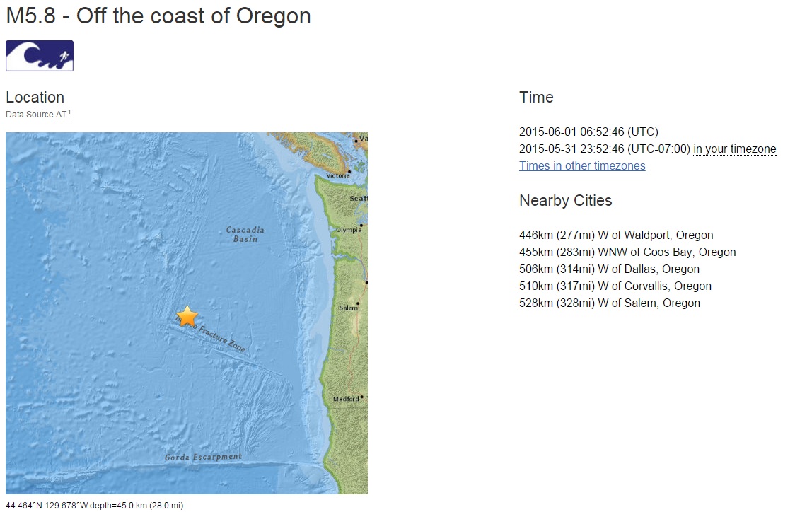
M5.8 - Off the coast of Oregon
earthquake.usgs.gov...
Time
2015-06-01 06:52:46 (UTC)
2015-05-31 23:52:46 (UTC-07:00) in your timezone
Times in other timezones
Nearby Cities
446km (277mi) W of Waldport, Oregon
455km (283mi) WNW of Coos Bay, Oregon
506km (314mi) W of Dallas, Oregon
510km (317mi) W of Corvallis, Oregon
528km (328mi) W of Salem, Oregon
files.abovetopsecret.com...
files.abovetopsecret.com...
earthquake.usgs.gov...
Time
2015-06-01 06:52:46 (UTC)
2015-05-31 23:52:46 (UTC-07:00) in your timezone
Times in other timezones
Nearby Cities
446km (277mi) W of Waldport, Oregon
455km (283mi) WNW of Coos Bay, Oregon
506km (314mi) W of Dallas, Oregon
510km (317mi) W of Corvallis, Oregon
528km (328mi) W of Salem, Oregon
edit on 7/30/2012 by dreamfox1 because: (no reason given)
files.abovetopsecret.com...
files.abovetopsecret.com...
edit on 7/30/2012 by dreamfox1 because: (no reason given)
Aftershocks:
4.3 M 4.3 - Off the coast of Oregon
Time
2015-06-01 07:01:20 UTC
Location
44.535°N 129.755°W
Depth
10.0 km
earthquake.usgs.gov...
_________________
M5.5 - Off the coast of Oregon
Time
2015-06-01 10:46:27 (UTC)
2015-06-01 03:46:27 (UTC-07:00) in your timezone
Nearby Cities
435km (270mi) W of Waldport, Oregon
447km (278mi) WNW of Coos Bay, Oregon
494km (307mi) W of Dallas, Oregon
498km (309mi) W of Corvallis, Oregon
517km (321mi) W of Salem, Oregon
earthquake.usgs.gov...
______________
M4.4 - Off the coast of Oregon
Time
2015-06-01 14:46:35 (UTC)
2015-06-01 07:46:35 (UTC-07:00) in your timezone
Times in other timezones
Nearby Cities
453km (281mi) W of Waldport, Oregon
463km (288mi) WNW of Coos Bay, Oregon
512km (318mi) W of Dallas, Oregon
516km (321mi) W of Corvallis, Oregon
535km (332mi) W of Salem, Oregon
earthquake.usgs.gov...
I live on the West Coast and I just had the coolest earthquake dream. The only dream where I've been in an earthquake that I can remember. It felt like it was going for at least 30 seconds. Cars crashed in the street outside of my house in the dream. Sorry, I went a bit off-topic. It felt so real.
edit on 1-6-2015 by phoenixlights321 because: (no reason given)
edit on 1-6-2015 by phoenixlights321 because: (no reason
given)
I did search back to 1800 at the location on the map could not find any previous eq in the area. Anyone else have any luck?
Btw the map and the map it shows on the actual page are different lol
USGS
a reply to: whatnext21
Thank you will add to my book marks appreciate it.
Btw the map and the map it shows on the actual page are different lol
M5.2 - North of Svalbard
86.123°N 31.961°E depth=10.0 km (6.2 mi)
Time
2015-06-01 12:57:52 (UTC)
2015-06-01 07:57:52 (UTC-05:00) in your timezone
Times in other timezones
Nearby Cities
724km (450mi) NNE of Nord, Greenland
1809km (1124mi) N of Alta, Norway
1852km (1151mi) N of Tromso, Norway
1865km (1159mi) N of Zapolyarnyy, Russia
908km (564mi) N of Longyearbyen, Svalbard and Jan Mayen
USGS
a reply to: whatnext21
Thank you will add to my book marks appreciate it.
edit on 1-6-2015 by lurksoften because: (no reason given)
a reply to: lurksoften
I found this site has quite a few listed for that region. Last one that far north was at least 3 years ago almost to the day...
I found this site has quite a few listed for that region. Last one that far north was at least 3 years ago almost to the day...
5.1 magnitude earthquake
3 years ago at 03:27
May 26, 2012 UTC
Location:
Epicenter at 85.939, 32.186
North Of Svalbard
Depth: 10 km
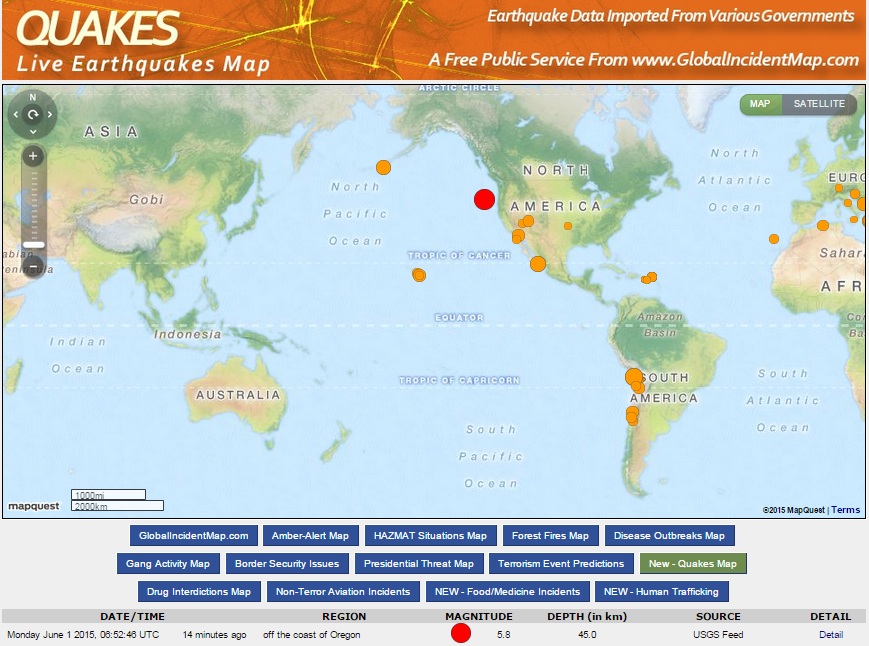
M6.0 - Off the coast of Oregon
earthquake.usgs.gov...
Time
2015-06-01 20:11:33 (UTC)
2015-06-01 13:11:33 (UTC-07:00) in your timezone
Times in other timezones
Nearby Cities
462km (287mi) W of Waldport, Oregon
471km (293mi) WNW of Coos Bay, Oregon
521km (324mi) W of Dallas, Oregon
525km (326mi) W of Corvallis, Oregon
544km (338mi) W of Salem, Oregon

files.abovetopsecret.com...
edit on 7/30/2012 by dreamfox1 because: (no reason given)
edit on 1-6-2015 by lurksoften because: already posted
a reply to: dreamfox1
yeah always watching get so many alerts for so much stuff.
If it stand will be larger than the 5.8. USGS likes to downgrades things though.
edit on 1-6-2015 by lurksoften because: (no reason
given)
5.9 now how low will she gooo
edit on 1-6-2015 by lurksoften because: (no reason given)
originally posted by: lurksoften
a reply to: dreamfox1
yeah always watching get so many alerts for so much stuff long time lurker lol
If it stand will be larger than the 5.8. USGS likes to downgrades things though.
And that would make yesturdays a foreshock which this one might be as well
earthquake.usgs.gov...
Still a foreshock if it stays this size
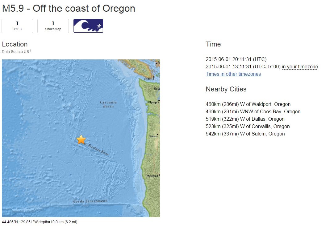
M5.9 - Off the coast of Oregon
Time
2015-06-01 20:11:31 (UTC)
2015-06-01 13:11:31 (UTC-07:00) in your timezone
Times in other timezones
Nearby Cities
460km (286mi) W of Waldport, Oregon
469km (291mi) WNW of Coos Bay, Oregon
519km (322mi) W of Dallas, Oregon
523km (325mi) W of Corvallis, Oregon
542km (337mi) W of Salem, Oregon
files.abovetopsecret.com...
Still a foreshock if it stays this size
M5.9 - Off the coast of Oregon
Time
2015-06-01 20:11:31 (UTC)
2015-06-01 13:11:31 (UTC-07:00) in your timezone
Times in other timezones
Nearby Cities
460km (286mi) W of Waldport, Oregon
469km (291mi) WNW of Coos Bay, Oregon
519km (322mi) W of Dallas, Oregon
523km (325mi) W of Corvallis, Oregon
542km (337mi) W of Salem, Oregon
files.abovetopsecret.com...
edit on 7/30/2012 by dreamfox1 because: (no reason given)
A 4.7 near Dunedin, South Island New Zealand, at 11:17 PM last night.
Geonet
Not common in this area.
Otago Daily Times
Strongest in the area since 1974
Geonet
Not common in this area.
Otago Daily Times
Strongest in the area since 1974
M5.1 - 58km S of Tanaga Volcano, Alaska
Time
2015-06-01 22:52:34 (UTC)
2015-06-01 15:52:34 (UTC-07:00) in your timezone
Times in other timezones
Depth: 51.4 km
58km (36mi) S of Tanaga Volcano, Alaska
1513km (940mi) SSE of Anadyr', Russia
1599km (994mi) E of Petropavlovsk-Kamchatskiy, Russia
1617km (1005mi) E of Yelizovo, Russia
2810km (1746mi) W of Whitehorse, Canada
earthquake.usgs.gov...
Now a 4.2
M 4.2 - Off the coast of Oregon
DYFI? - I
Time
2015-06-02 03:11:25 UTC
Location
44.758°N 129.650°W
Depth
10.0 km
Time
2015-06-02 03:11:25 (UTC)
2015-06-01 20:11:25 (UTC-07:00) in your timezone
Times in other timezones
Nearby Cities
442km (275mi) W of Depoe Bay, Oregon
461km (286mi) WNW of Coos Bay, Oregon
500km (311mi) W of Dallas, Oregon
506km (314mi) W of Corvallis, Oregon
523km (325mi) W of Salem, Oregon
earthquake.usgs.gov...
a reply to: muzzy
wedge of cheese with that earthquake?
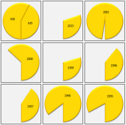
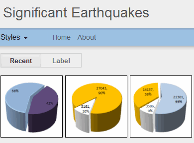
this is what I was trying to achieve with the thumbnails, show how each year stacked up in comparison with the other years.
So what each cheese wheel shows in the total amount of energy released that year.
The base line is anything over 100,000KT of energy released in that year is a complete cheese wheel, such as 1960, the year of the M9.5 in Chile.
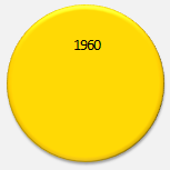
Full cheese wheels will show for any year when there was a M8.55 or bigger or the total for the year adds up to anything over 100,000KT. That is a compromise, as when I set 1960 as a base the other years were such a thin slice you couldn't hardly see it.
It will look better when I get more done, hopefully a few more in the next couple of days, the weather is crappy.
I will probably just load the maps and the thumbnails first and then go back and add the list and summaries later.
significantearthquakes.blogspot.co.nz...
wedge of cheese with that earthquake?
this is what I was trying to achieve with the thumbnails, show how each year stacked up in comparison with the other years.
So what each cheese wheel shows in the total amount of energy released that year.
The base line is anything over 100,000KT of energy released in that year is a complete cheese wheel, such as 1960, the year of the M9.5 in Chile.
Full cheese wheels will show for any year when there was a M8.55 or bigger or the total for the year adds up to anything over 100,000KT. That is a compromise, as when I set 1960 as a base the other years were such a thin slice you couldn't hardly see it.
It will look better when I get more done, hopefully a few more in the next couple of days, the weather is crappy.
I will probably just load the maps and the thumbnails first and then go back and add the list and summaries later.
significantearthquakes.blogspot.co.nz...

a reply to: Darkblade71
Ha ha yeah, I thought that to after I had done a few, I could probably make an animation of them chomping
a reply to: crappiekat
glad you like it, it's a bit brighter too eh, those 3D pie ones where OK, but I just couldn't get the right colour mix.
I'm getting a lot of full cheese wheels, hopefully I didn't set the base line too low at 100,000KT
Most regular ATS readers know how these things work by now, but I'll posts the "how it works" here for new readers.
With the Flipcard style Home Page, each panel represents a year, each segment shown is a rendering of the amount of energy released that year by all earthquakes above M6.5 as a percentage of a full circle. The base line for a full circle is anything over 100,000KT of energy released. When you hover your mouse over the panel it will flip over to reveal the year in text on a black background Clicking on this will open the page, with an World Map showing the locations of all the earthquakes above M6.5. Clicking the map opens an interactive version. It will open in a new Tab, or Window, depending on which Browser you are using. All events have further information inside a popup tag that will show when you click either the icon or click the relevant line of text on the left column on the Bing map page. Beneath the map is a text list of the earthquakes that are on the map. Below the list is a summary of how many and how much energy released by each number of magnitude.
edit on 0600000015215215 by muzzy because: (no reason given)
new topics
-
Biden "Happy To Debate Trump"
Mainstream News: 8 minutes ago -
RAAF airbase in Roswell, New Mexico is on fire
Aliens and UFOs: 17 minutes ago -
What is the white pill?
Philosophy and Metaphysics: 1 hours ago -
Mike Pinder The Moody Blues R.I.P.
Music: 2 hours ago -
Putin, Russia and the Great Architects of the Universe
ATS Skunk Works: 5 hours ago -
A Warning to America: 25 Ways the US is Being Destroyed
New World Order: 10 hours ago
top topics
-
President BIDEN's FBI Raided Donald Trump's Florida Home for OBAMA-NORTH KOREA Documents.
Political Conspiracies: 15 hours ago, 34 flags -
A Warning to America: 25 Ways the US is Being Destroyed
New World Order: 10 hours ago, 18 flags -
Mike Pinder The Moody Blues R.I.P.
Music: 2 hours ago, 6 flags -
What is the white pill?
Philosophy and Metaphysics: 1 hours ago, 5 flags -
Is AI Better Than the Hollywood Elite?
Movies: 17 hours ago, 4 flags -
RAAF airbase in Roswell, New Mexico is on fire
Aliens and UFOs: 17 minutes ago, 3 flags -
Putin, Russia and the Great Architects of the Universe
ATS Skunk Works: 5 hours ago, 2 flags -
Biden "Happy To Debate Trump"
Mainstream News: 8 minutes ago, 2 flags -
Maestro Benedetto
Literature: 17 hours ago, 1 flags
active topics
-
A Warning to America: 25 Ways the US is Being Destroyed
New World Order • 25 • : theatreboy -
ChatGPT Beatles songs about covid and masks
Science & Technology • 25 • : ArMaP -
Gaza Terrorists Attack US Humanitarian Pier During Construction
Middle East Issues • 77 • : KrustyKrab -
Biden "Happy To Debate Trump"
Mainstream News • 2 • : nugget1 -
What is the white pill?
Philosophy and Metaphysics • 12 • : nerbot -
Supreme Court Oral Arguments 4.25.2024 - Are PRESIDENTS IMMUNE From Later Being Prosecuted.
Above Politics • 91 • : Sookiechacha -
President BIDEN's FBI Raided Donald Trump's Florida Home for OBAMA-NORTH KOREA Documents.
Political Conspiracies • 30 • : xuenchen -
-@TH3WH17ERABB17- -Q- ---TIME TO SHOW THE WORLD--- -Part- --44--
Dissecting Disinformation • 692 • : 777Vader -
New whistleblower Jason Sands speaks on Twitter Spaces last night.
Aliens and UFOs • 71 • : introufo2 -
University of Texas Instantly Shuts Down Anti Israel Protests
Education and Media • 276 • : cherokeetroy