It looks like you're using an Ad Blocker.
Please white-list or disable AboveTopSecret.com in your ad-blocking tool.
Thank you.
Some features of ATS will be disabled while you continue to use an ad-blocker.

Quake Watch 2016
page: 56share:
originally posted by: PuterMan
a reply to: muzzy
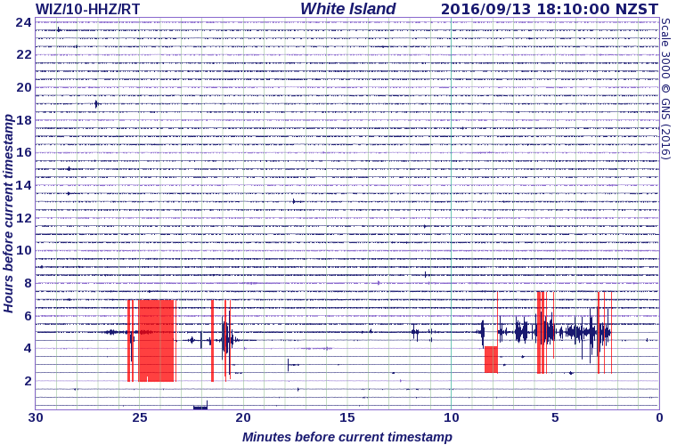
Do you reckon this might upset White Island?
I know there has been activity there over the last year. albeit low.
27 felt reports on USGS by the way.
Yep
Minor Ash eruption at White Island ,NZ
Note on the siesmograph how the traces are a different shape to the normal geonet seismos for normal earthquakes ie they are volcanic tremors
edit on 0900000025625616 by muzzy because: (no reason given)
Umm.
I wouldn't comment, but, 10 earthquakes around Oklahoma all above 2.5M.
I think they're trying to pump while they still can. Or, they're trying to cause a disaster.
I wouldn't comment, but, 10 earthquakes around Oklahoma all above 2.5M.
I think they're trying to pump while they still can. Or, they're trying to cause a disaster.
I have sort of got a standardized layout going with my reports on the large quake aftershock series now on Blooger.
While having to break the data into 197-199 bundles(lines) for Bing Maps viewing is a bit of a PITA, it can also give an overall view of the series as good as the earlier work I did with Google Maps and Wordpress where I broke it down to days-elapsed time maps.
The bundle graphs show how the magnitudes decrease over time (or show when there is a surge or resurge), and the area bundles can show how the aftershocks shifted in location over the period.
So the question now is, "how long is a suitable period" to track the data?
I am always trying to look at the bigger picture, even though each page is about one particular event.
The first series I did these bundles for was SW off Kyushu where I went for 21 bundles, which worked out to 219 days (quite a long series to just get to 21 bundles), but by that point there were days of no aftershocks or just 1 or 2 /day, then Kyushu activity shifted to Kumamoto not far away.
Kumamota (still going) is currently at 85 bundles, worth 150 days after the 7.1, with no sign of easing off because of all those ~M1 aftershocks showing up. *I just noticed that I have to go back and redo the last 10 bundles, as the elapsed time is not showing due to a column shift in the data after the reboot of Datapro following the break down at the end of August.
L'Aquilla I did 30 bundles which covered only 12.4 days, but I have data that goes for 270 days (17,040 events)
Accumoli (still going) 35 bundles brings it to 16 days
I'm working on Van, Turkey 2011 at the moment and have created 40 bundles which covers 3 months, but at that point it was still going steady at 18-20 per day.
A lot of series aftershocks don't last very long, eg East Cape Ridge has already died away after just 9 days (6 bundles)
Borrego Springs 8 bundles took it to 8 days
So repeating the question again "how long is a suitable period" to track the data?
till the aftershocks stop or the data runs out?
for 3 months?
6 months?
12 months? (*Christchurch lasted for over 6 years!)
A fresh though I just had today while doing Van, is what are readers looking for if they do actually use the Bing Map Bundles?,
click on each map number and go through the lot?
or are they trying to find something in particular?
With Van there were several M5's well into the series, at 17,22,26,37 and 42 days elapsed time, but how do you find the Bing map that shows each one?
I couldn't find them myself without going through the raw data. So I might make the bundle number with the M5's orange colour, so it stands out from the rest of the blue link numbers.
Another new feature that I took from L'Aquilla was the Town locations table, and I have used it on Accumoli as well, and plan to do so for Van.
This might be interesting for locals to read, they know themselves what happened in their town, but sometimes the actual facts don't match up.
This could be expanded to having a map for each town?, although you can see that on the main NZ Topo map by zooming in and out and scrolling.
Early days for the Blogger EQArchives, so I thought I would ask before I write a whole bunch of stuff no one will read.
eqarchives.blogspot.co.nz...
BTW I will bring the big Japanese pages in when I get the time, and they will be under the japan label (obviously)
Just had a wakeup call about preparedness for an emergency this morning.
It's raining so I'm at home.
We haven't had electricity for 2 hrs so no lights, Internet, radio, TV or most importantly NO HOT COFFEE!
I couldn't find our battery powered radio anywhere in the end I thought ah ha my phone has a radio. Got it tuned into the local station (I had to look up the phone book to get their frequency!) listened for half an hour, no bulletins about the power loss.
So using my cell phone again phoned the power retailer, still waiting for them to call back after an hour, they had no idea.
Then I phoned the power line company, took 5 minutes waiting until they checked it out, seems they are putting in a new transformer down the street. Good of them to put a notice in the mailbox that this was planned for today.
I would have made a flask of hot coffee if I had known.
Lucky we have an lpg BBQ so I will find an old pot and boil up the billy soon.
Makes me wonder how we would really cope if it had been something more serious like a big earthquake or a tsunami coming.
Off to look for the transistor radio it could be in our emergency boxes somewhere, does it have live batteries?
Where is my backup cell phone charge stick? I know that's flat.
Have 1hr 11 minutes left on my laptop, but no Internet, unless I plug it into my phone, and that it at 85% itself. That would drain down pretty quickly if I did so.
a reply to: muzzy
Just a quick post.
I forgot how to do it, connect via mobile phone. I did it before when I worked out of town a few years ago.
Set a hotspot on the cell and then come in from the laptop via wi-fi.
At least as long as the cell network survives I will be able to post the soonest details of the crisis after the Alpine Fault M8+ (promised to happen within my lifetime) on ATS
2.5hrs to go yet with no power.
I have connected my cell phone backup battery to my car charger for a couple of hours, just in case they don't get the transformer back up and running. That will give me another half days cell power.
A good dry run test, if nothing else.
14% power left on my laptop battery now. Not sure how to overcome that.
Shutting down now.
edit on 0900000025625616 by muzzy because: (no reason given)
a reply to: muzzy
You are doing the preparedness incorrectly my friend!
It should be a matter of 1, 2, 3, done!
Choose one item as your principal communication back-up.
A truck or tractor battery will do. Just keep it on float charge with a small solar array as backup. As a second backup, you can jumper it to your car and charge it while driving.
P
a reply to: pheonix358
Back on the power grid.
That was interesting. We have NEVER been without power in this area where we have lived for 21 years for so long, 8hrs.
Yes you are right pheonix.
The cell network is the most practical, as you can take it with you.
Trouble is where our house is at the mobile internet reception is poor, its OK for phone calls, but takes forever to connect to the web and often times out.
I'm glad we didn't go with a complete internet telephone system when we shifted 9 months ago, although it was cheaper and sounded wonderful it was this very situation (no power) that turned us off it.
As I said I charged up my cell phone backup stick off my car for about an hour, when I put it to my phone it charged it up to 100%. I might get some more of those and keep them fully charged. If the big one hits the cell network will 99% for sure go down, but it will be back up quickly, as was seen in Christchurch in 2011.
edit on 0900000025725716 by muzzy because: (no reason given)
originally posted by: muzzy
I'm working on Van, Turkey 2011 at the moment and have created 40 bundles which covers 3 months, but at that point it was still going steady at 18-20 per day.
A fresh thought I just had today while doing Van, is what are readers looking for if they do actually use the Bing Map Bundles?,
click on each map number and go through the lot?
or are they trying to find something in particular?
With Van there were several M5's well into the series, at 17,22,26,37 and 42 days elapsed time, but how do you find the Bing map that shows each one?
I couldn't find them myself without going through the raw data. So I might make the bundle number with the M5's orange colour, so it stands out from the rest of the blue link numbers.
A day late (due to power cut), well 4 years late really, I have been sitting on this data since the end of 2012.
Finally processed it and have done 40 bundles x 199 events so far. I will do the rest to 365 day elapsed time when I get the chance.
Van, Turkey 2011
*sorry about the scroll bar being hidden behind the popout menu on the right hand side, thats the Blogger template fault, I can shift the menu to the other side but it causes other problems with the template.
You just need to use the arrow at the bottom to get it moving down a bit, or use your mouse scrolling wheel if you have one
edit on
0900000025725716 by muzzy because: (no reason given)
Yes, yes, yes. I have found more proof of earthquakes induced by water and the tides. Kobe, 1995. It's a perfect example.
I watched a documentary about Kobe. I began to wonder about it since it has a big bay. I thought, hmmm, no. I'm sure the moon and tides didn't mean a thing. Well, they did. The tides were high, the moon full, and I even found records that say Kobe had lots, and lots of rain just before the earthquake. In fact, I found someone who had the same thinking and there's a book and a story about this exact scenario...
cool -
evidence I'm not completely obsessed for no good reason. Again, the key, water...
books.google.ca... n&sa=X&ved=0ahUKEwin7MSb0o_PAhWc14MKHULqAtgQ6AEIKDAC#v=onepage&q=rainfall%20kobe%20japan%201995&f=false
I'm not sure if that link works...
Here is the title is you want. I'm not even sure that the conclusion agrees with me or not. I haven't gotten that far. I got excited that there is an argument and people are seriously exploring the idea that the tides and season rainfall patterns are connected. I know correlation does not show causation. But you get enough correlations and the pattern because an obvious source of evidence to prove causation, or at the least, the extent of the relationship...
There is one...
And I'm going even one step further to say that air pressure and wind, all with storm surges, along with rainfall patterns, etc, give a much bigger picture of the many dynamic factors that must be calculated when thinking about earthquakes and the causes. If we factor everything in, we may be able to have a risk assessment that more closely resembles a weather forecast.
Oh, here's a site with more info.
www.springer.com...
a reply to: ericblair4891
So we can expect a large quake in China today?
That typhoon they are having right now has the lowest pressure ever recorded
So we can expect a large quake in China today?
That typhoon they are having right now has the lowest pressure ever recorded
a reply to: muzzy
I don't know. I just went and checked that cool nullschool thingy wind map. Man is it cool. Yes, there's a doozy of a storm bearing down on China. And, yeah, with the tides starting to come up from the full moon, maybe...
Oh, and this is weird, I get a news alert for earthquakes. When I just opened it a minute ago, the first story was about the tides. Kid you not. It was strange since I just went and looked up Kobe and the tides.
This is a brand new article as of 19 hours ago...
I hadn't read anything in regular news so this was just a coincidence.
Taiwan might get something...
time.com...
www.spacedaily.com...
weather.com...
But it's not like I haven't been ranting about the moon for years now... so it ain't news to me
edit on 14-9-2016 by ericblair4891 because: (no reason given)
a reply to: ericblair4891
the only problem with the theory is all the big quakes that didn't coincide with the things you mention, about 50%+ of them from my research in previous years.
There seems to be a bit of talk on this going around, someone must be pushing a book launch.
Enough that they had a scientist from Geonet write an article in our regional paper poopooing the theory earlier this week.
Geofon are giving some quite high mb conversions for todays East Cape Ridge quakes
2016-09-14 17:55:35 5.2 37.40°S 179.78°E 10 C Off E. Coast of N. Island, N.Z.
2016-09-14 16:09:30 5.2 37.20°S 178.79°E 15 M Off E. Coast of N. Island, N.Z
the Geonet numbers (ML) way lower
respectively
4.976ML
4.591ML
2016-09-14 17:55:35 5.2 37.40°S 179.78°E 10 C Off E. Coast of N. Island, N.Z.
2016-09-14 16:09:30 5.2 37.20°S 178.79°E 15 M Off E. Coast of N. Island, N.Z
the Geonet numbers (ML) way lower
respectively
4.976ML
4.591ML
a reply to: ericblair4891
I just read the Time link you put on, its the same text that was on the local newspaper story, so they must have picked up the article from there and added the Geonet response.
The Tokyo based study release must be what is behind all the discussion about tides right now.
They basically cherry-picked the events that met the criteria of their theory
edit on 0900000025825816 by muzzy because: (no reason given)
a reply to: muzzy
I don't dispute the fact that not all major earthquakes line up with the tides. As I have been trying to articulate, there are many factors. And they don't "Cause" the earthquake. There are the faults themselves that move due to "whatever" pressure. Whether you believe in plate tectonics, an expanding earth, or anything else. Force from different directions and sources, crack the earth. I'm saying, that water, and the other stuff I mention, are "Triggers". They are the gentle squeezing that sets off the explosion. Just like a gun. The pressure of your finger, sets off a chain reaction. And, the fault has to be ready to rupture. As, the story suggest, the tides raise the odds that something will squeeze a trigger. But if there's no load, no bullet in the chamber, the squeezing causes only a soft clicking.
And, as I have stated before, the effect of tides, etc, don't happen at the exact stroke of midnight. Lag, and other factors mess up a neat connection. Water is dynamic. Sometimes, it takes awhile before all the water gets into a system, and more time, maybe till the next lunar cycle, it discharges the energy. Like a pump. Or, like a piston in a car. The explosion happens at the top stroke, but there's also a down stroke with draws in the fuel and creates a mixture. Maybe that's what happens in faults, also, like the same thing that happens in liquefaction. The solids sink when shaken, then water moves up and down, and mixes with gases, making it even less dense and the fluid moves upward. All these changes, would prime the pump. Until, maybe like diesel engine, until the right pressure and heat levels are achieved. Then boom.
The trigger is merely a spark. A tiny action, that sets of a chain reaction. The odds are small, but someone has to win the lottery...
a reply to: ericblair4891
No one has had much luck predicting the lottery either
I do agree the water, tides and the Moon do have an influence in some cases though
No one has had much luck predicting the lottery either
I do agree the water, tides and the Moon do have an influence in some cases though
Its a VERY wet Saturday morning and I was just updating Kumamoto earthquakes series.
I went to test the Bing maps from 75th onwards as I think I put the elapsed time in the wrong column in the CSV file so it probably won't show on the Bing Maps popup tags.
None of the text links on the blog seem to connect and bring up the icons,
japanquakes.blogspot.co.nz...
Its the same on NZEQ2016
could be a temporary fault at Bing, or Dropbox, not surewhich
what I note is at the end of the address after the .kmz end is added "&ignoreoptin=1"
I have never seen that before
googling the &ignoreoptin=1 doesn't bring anything up.
I know you can't use the Bing Maps on your cell phone but it HAS worked on desk or lap tops.
Anyone have the same results?
This really pisses me off, first Google discontinued Classic Maps, now this hassle.
All i want to do is get the information out, I'm not making any money out of it.
I'm getting sick of these services setting up systems that work OK for a whilethen they go and change things and there is soooooooo much time wasted re-doing stuff over and over to make it work again.
edit on 0900000025925916 by muzzy because: (no reason given)
new topics
-
President BIDEN's FBI Raided Donald Trump's Florida Home for OBAMA-NORTH KOREA Documents.
Political Conspiracies: 3 hours ago -
Maestro Benedetto
Literature: 4 hours ago -
Is AI Better Than the Hollywood Elite?
Movies: 4 hours ago -
Las Vegas UFO Spotting Teen Traumatized by Demon Creature in Backyard
Aliens and UFOs: 8 hours ago -
2024 Pigeon Forge Rod Run - On the Strip (Video made for you)
Automotive Discussion: 9 hours ago -
Gaza Terrorists Attack US Humanitarian Pier During Construction
Middle East Issues: 9 hours ago -
The functionality of boldening and italics is clunky and no post char limit warning?
ATS Freshman's Forum: 10 hours ago -
Meadows, Giuliani Among 11 Indicted in Arizona in Latest 2020 Election Subversion Case
Mainstream News: 11 hours ago -
Massachusetts Drag Queen Leads Young Kids in Free Palestine Chant
Social Issues and Civil Unrest: 11 hours ago
top topics
-
President BIDEN's FBI Raided Donald Trump's Florida Home for OBAMA-NORTH KOREA Documents.
Political Conspiracies: 3 hours ago, 23 flags -
Krystalnacht on today's most elite Universities?
Social Issues and Civil Unrest: 14 hours ago, 9 flags -
University of Texas Instantly Shuts Down Anti Israel Protests
Education and Media: 17 hours ago, 8 flags -
Weinstein's conviction overturned
Mainstream News: 12 hours ago, 8 flags -
Supreme Court Oral Arguments 4.25.2024 - Are PRESIDENTS IMMUNE From Later Being Prosecuted.
Above Politics: 14 hours ago, 8 flags -
Massachusetts Drag Queen Leads Young Kids in Free Palestine Chant
Social Issues and Civil Unrest: 11 hours ago, 7 flags -
Gaza Terrorists Attack US Humanitarian Pier During Construction
Middle East Issues: 9 hours ago, 7 flags -
Las Vegas UFO Spotting Teen Traumatized by Demon Creature in Backyard
Aliens and UFOs: 8 hours ago, 6 flags -
Meadows, Giuliani Among 11 Indicted in Arizona in Latest 2020 Election Subversion Case
Mainstream News: 11 hours ago, 5 flags -
2024 Pigeon Forge Rod Run - On the Strip (Video made for you)
Automotive Discussion: 9 hours ago, 4 flags
active topics
-
Hate makes for strange bedfellows
US Political Madness • 47 • : 19Bones79 -
-@TH3WH17ERABB17- -Q- ---TIME TO SHOW THE WORLD--- -Part- --44--
Dissecting Disinformation • 689 • : daskakik -
University of Texas Instantly Shuts Down Anti Israel Protests
Education and Media • 265 • : Astrocometus -
Gaza Terrorists Attack US Humanitarian Pier During Construction
Middle East Issues • 27 • : ToneD -
Reason of the Existence
The Gray Area • 21 • : BingoMcGoof -
President BIDEN's FBI Raided Donald Trump's Florida Home for OBAMA-NORTH KOREA Documents.
Political Conspiracies • 10 • : nugget1 -
Supreme Court Oral Arguments 4.25.2024 - Are PRESIDENTS IMMUNE From Later Being Prosecuted.
Above Politics • 85 • : Sookiechacha -
Chris Christie Wishes Death Upon Trump and Ramaswamy
Politicians & People • 24 • : nugget1 -
New whistleblower Jason Sands speaks on Twitter Spaces last night.
Aliens and UFOs • 63 • : pianopraze -
SETI chief says US has no evidence for alien technology. 'And we never have'
Aliens and UFOs • 74 • : Justoneman