It looks like you're using an Ad Blocker.
Please white-list or disable AboveTopSecret.com in your ad-blocking tool.
Thank you.
Some features of ATS will be disabled while you continue to use an ad-blocker.

Quake Watch 2016
page: 58share:
I thought I would post this here on ATS as there have been some changes on my japanquakes blog over the last week, and I know from my blog Pageview
Stats that there are definitely readers coming to my blog from Quake Watch ATS.
These are pretty big changes, such as the day going from UTC to being JST, the crashing of Bing Maps and a new idea I had yesterday of using miniature timeline graphs on the Flipcard home page instead of the pie graphs ( an issue with W10 update messing with my page layouts on Excel).
NAVIGATION OF POSTS (PAGES)
On the Home Page, which is set to "Flipcard" style, each card/panel/image represents one day/24hours time period. The "days" are determined using JST time after 15th September, although both UTC and JST are shown in the popup tags on the interactive maps. Prior to 15th Sept the "day" is UTC.
GRAPHS/PIE CHARTS
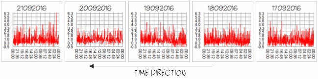
Post 15th September the Flipcard card/panel/image shows a tiny version of the daily timeline of events of the JST day, they are laid out to read right to left. The reason they are laid out this way is that when looking at the whole page you can see the trend for the whole 10 days on each row. The last graph/card/panel/image is always the one on the left, this is due to the format of the blog itself.
example layout on the Flipcard style home page
example of 5 days of graphs on Flipcard
what the graphs might look like if joined as one
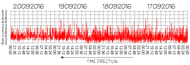
The actual full sized timeline graph is shown at the bottom of each days page, with the bigger earthquakes tagged with the locations. The timeline maps are just a guide to when certain events occurred and are not particularly detailed, on average each day there are 600 earthquakes and creating a graph with the location of each marked on it would be messy.
*NOTE. There was a failure of the Picasa image hosting files for Japan when Google took over Picasa in August 2016 and I lost all the pie charts/graphs, therefore there are no pies/graphs on the flipcard home page prior to 1st July. I am slowly working backwards as time allows and creating new graphs for this.
japanquakes.blogspot.co.nz...
One other reason I've changed again away from the pie charts (again) is that Japan (NIED) seem to have a fixed quota of located earthquakes per day (around about 600) and I have noted that the numbers per day don't really change that much.
I think the timeline graphs might be more useful, as you can see in what sequence the bigger events occurred.
The blog will be a bit of a hodgepodge for a bit, while I go back and change each days layout ( back to July 1st initially)
These are pretty big changes, such as the day going from UTC to being JST, the crashing of Bing Maps and a new idea I had yesterday of using miniature timeline graphs on the Flipcard home page instead of the pie graphs ( an issue with W10 update messing with my page layouts on Excel).
NAVIGATION OF POSTS (PAGES)
On the Home Page, which is set to "Flipcard" style, each card/panel/image represents one day/24hours time period. The "days" are determined using JST time after 15th September, although both UTC and JST are shown in the popup tags on the interactive maps. Prior to 15th Sept the "day" is UTC.
GRAPHS/PIE CHARTS
Post 15th September the Flipcard card/panel/image shows a tiny version of the daily timeline of events of the JST day, they are laid out to read right to left. The reason they are laid out this way is that when looking at the whole page you can see the trend for the whole 10 days on each row. The last graph/card/panel/image is always the one on the left, this is due to the format of the blog itself.
example layout on the Flipcard style home page
example of 5 days of graphs on Flipcard
what the graphs might look like if joined as one
The actual full sized timeline graph is shown at the bottom of each days page, with the bigger earthquakes tagged with the locations. The timeline maps are just a guide to when certain events occurred and are not particularly detailed, on average each day there are 600 earthquakes and creating a graph with the location of each marked on it would be messy.
*NOTE. There was a failure of the Picasa image hosting files for Japan when Google took over Picasa in August 2016 and I lost all the pie charts/graphs, therefore there are no pies/graphs on the flipcard home page prior to 1st July. I am slowly working backwards as time allows and creating new graphs for this.
japanquakes.blogspot.co.nz...
One other reason I've changed again away from the pie charts (again) is that Japan (NIED) seem to have a fixed quota of located earthquakes per day (around about 600) and I have noted that the numbers per day don't really change that much.
I think the timeline graphs might be more useful, as you can see in what sequence the bigger events occurred.
The blog will be a bit of a hodgepodge for a bit, while I go back and change each days layout ( back to July 1st initially)
Dang that fault area is really got alot of get up and go.
earthquake.usgs.gov...
6.3 SE of Tamisan, Philippines.
I wonder if something will really let loose in that area.
Alot of movement.
Ahha,
TA already has a Thread on it.
www.abovetopsecret.com...
earthquake.usgs.gov...
6.3 SE of Tamisan, Philippines.
I wonder if something will really let loose in that area.
Alot of movement.
edit on 23-9-2016 by crappiekat because: to add
Ahha,
TA already has a Thread on it.
www.abovetopsecret.com...
edit on 23-9-2016 by crappiekat because: to add
a reply to: crappiekat
thanks, I will go with that style for a while.
I just went to the blog I was doing on 6.5+ quakes, thats a total blank now, all the maps going back to 1867 were based on using Bing maps to show where the earthquakes were. A years work down the drain.
I am pretty angry, first Google Maps then Bing Maps pulling the plug.
what is wrong with these morons?
If they think people are going to pay for the service then they are wrong, I for one will be bad mouthing both to everyone I meet.
I can make my own semi-interactive maps, but it takes a lot of code writing (HTML) and I really haven't got the time.
Okay, bear withe me. I'm old, so my famous person impression might only hit target my intended victim, and miss the younger folk.
"Hey, ABBOTT!!!!!!!" er, I mean "Hey, PUTERMANNNN!"
Puterman,
again we have earthquakes out there in the Atlantic, and at the same time, we have the Nullschool wind map showing strong winds right on top, and at the same time, we have a big storm bearing down on that same spot. I haven't forgot that you and I both have observed that in the autumn, we start get lots of earthquakes near Iceland. Well, right now, we have the trifecta. It just turned fall, the winds are there, and the low pressure is swirling around in the North Atlantic.
The real reason I'm probably thinking of you is the weather. We used to argue about global warming all the time. We just had a ridiculous summer, and Muzzy is making me look for sunspots... But forget that, your Welsh. I read sad news about the Welshman Terry Jones, he's in bad shape and is doing no more interviews. Yes, I loved Python, but I'm a history buff, and I watched all his other stuff. He loved history and could find something to ridicule in any century...
Oh, what else. ah, nothing.
I was just noticing the big map, and the ocean quakes jumped out at me. Yesterday, the Romanian earthquake made me go hmmm, but not really. They have mountains and earthquakes so there's nothing rare there. Maybe Italy kicked of this nearby earthquake... I wouldn't be surprised, but there's nothing to point to as a pattern in the region. Macedonia had one in the last 30 days, and Greece had some bunches. But they always get them... so nothing above a normal level.
originally posted by: muzzy
I just went to the blog I was doing on 6.5+ quakes, thats a total blank now, all the maps going back to 1867 were based on using Bing maps to show where the earthquakes were. A years work down the drain.
I am pretty angry, first Google Maps then Bing Maps pulling the plug.
what is wrong with these morons?
If they think people are going to pay for the service then they are wrong, I for one will be bad mouthing both to everyone I meet.
I'm not going to give up, I have put too much work into this, I said a years work, but that was just the conversion to Bing Maps. I've been working on this blog for over 5 years now.
So what to do?
I went back 10 months to when I was experimenting with ikiMaps.
They do work, but its a Beta program (still under development).
As it happens I already created several ikiMaps 10 months ago, so have something at hand to test out again.
The iframe which puts the interactive map directly on your web page doesn't work properly. there is no background map, although the icons show up. There is no button to select a map background, which should be there.
So that's no use.
What I have done is make a screenshot and link to the full page ikimap through that (similar to how Bing Maps worked)
I have rewritten the code for 1996 and republished it
have a look and see what you think.
significantearthquakes.blogspot.co.nz...
Once on the ikiMap page for 1996 you need to click on one of the maps in the drop down menu on the left, to bring up the background map.
I tested it on my phone, it works but its not specifically setup for mobile so you have to scroll a lot to get to 1996, and you can't expand the map for a closer view.
edit on 0900000026726716 by muzzy because: (no reason given)
when I first published the 1996 map and went to view it I had to click on some of the map buttons twice to get them to work, not sure why. I went and deleted cookies on Internet Options and it seems to work OK now.
I'll see if I can do a couple more years, I see I did quite a few other ikiMaps for this blog.
Can't remember why I didn't continue, although the ikiMaps dashboard can be frustrating to work on, its a Spanish site.
edit on
0900000026726716 by muzzy because: (no reason given)
Great, I just did 1997 as well, which I had already on ikiMaps, works OK.
I notice that the Bing Maps button doesn't work on ikiMaps. So they are screwing everyone around.
I noticed recently that even Geonet were having trouble with their maps, the backgrounds not showing and they have stopped using NZ Topo as an overlay, hope this doesn't mean NZ Topo is going to crash as well as Google and Bing!,
rewriting NZ's and Japans earthquakes on ikiMaps is not going to be an option I want to even consider.
edit on 0900000026726716 by muzzy
because: (no reason given)
another edit: Yep on a roll now.
The screenshot below is what you should be able to see on 2016, the last M7 at East Cape Ridge.
I prefer Open Street Maps myself, but you can switch to Google if you really need to.
It would be great if they did a deal with National Geographic Maps, their maps are nice, USGS use them.
back of my mind though the whole time those bastards at Microsoft (Bing) and Google drawing $million salaries while giving no thought whatsoever of how much trouble they have caused thousands if not millions of users of their products. What a waste of time they are.
enough complaining and talking, time to just get on with it, using open source programs
edit on 0900000026726716 by muzzy because: (no
reason given)
a reply to: ericblair4891
I hear you. I was thinking the same thing and only said to her indoors a couple of days ago that the Iceland earthquakes off the south west would be starting.
again we have earthquakes out there in the Atlantic, and at the same time, we have the Nullschool wind map showing strong winds right on top, and at the same time, we have a big storm bearing down on that same spot.
I hear you. I was thinking the same thing and only said to her indoors a couple of days ago that the Iceland earthquakes off the south west would be starting.
On my phone don't know how to link.
Went through a dead zone ad I hit reply,
& lost everything!
6.4 in Tonga & 6.9 in Fiji.
Quite a few higher mag ones,
in the last couple of days in diverse places.
Pressure from a bigger one in the works?
WOQ
Went through a dead zone ad I hit reply,
& lost everything!
6.4 in Tonga & 6.9 in Fiji.
Quite a few higher mag ones,
in the last couple of days in diverse places.
Pressure from a bigger one in the works?
WOQ
a reply to: wasobservingquietly
I just saw these two bigger ones. At first, I thought they are two different zones. But, they are under 400 km from each other. I was going to called it a double tap, or a coupling, but, I don't know with find the specific faults. It's not directly on the big ones. Given, that the map shows a big gap near Fiji, who knows.
Okay Puterman, so what's the cause. Do you think it happens when the earth tilts? A tipping point?
Maybe something sloshes around inside the earth and this puts pressure under the Atlantic crust. The magma pushing up, hence, putting pressure on the rift. Or, is it the seasonal shift in storms and winds and such? Maybe colder denser waters sinking and moving pressure points along the ridge itself. Like someone running their hands up and down both sides of your spine during a massage. Whatever!? Something is happening and it is very seasonal. Forget about everywhere else. In the North Atlantic, there are seasonal earthquakes. It's a fact.
Oh, and the 6.4M happened just before the other. Meaning, is it a fore-shock? Or, did it trigger the larger one?
edit on 24-9-2016 by ericblair4891 because: (no reason given)
a reply to: wasobservingquietly
earthquaketrack.com
6.4 magnitude earthquake
Today about 2 hours ago at 21:07
September 24, 2016 UTC
Location:
Epicenter at -18.127, -175.039
124.2 km from Neiafu (77.2 miles)
6.9 magnitude earthquake
Today about 2 hours ago at 21:28
September 24, 2016 UTC
5.0 magnitude earthquake
Today about 2 hours ago at 21:55
September 24, 2016 UTC
earthquaketrack.com
Folks, I'm starting to feel like I'm in a bad sci-fi movie, just north of New Zealand, and just south of the two 6+Ms near Figi, there's a bunch more.
5.8M
5.2M
4.9M
5.1M
In the last 24 hours. Three in last hour.
I'm hoping this is it for the cluster and that it's not leading up to something bigger. So, along with Japan last week, now we another region with some clusters.
Had to edit, there's been revisions to those and more added. the list for the last 24 hours is...
4.9
146km SE of L'Esperance Rock, New Zealand
2016-09-25 00:28:00 (UTC)
10.0 km
4.7
135km SE of L'Esperance Rock, New Zealand
2016-09-25 00:25:10 (UTC)
10.0 km
5.1
129km SE of L'Esperance Rock, New Zealand
2016-09-24 23:52:03 (UTC)
10.0 km
4.9
121km SSE of L'Esperance Rock, New Zealand
2016-09-24 23:42:49 (UTC)
10.0 km
5.2
118km SE of L'Esperance Rock, New Zealand
2016-09-24 23:27:19 (UTC)
10.0 km
5.8
177km SE of L'Esperance Rock, New Zealand
2016-09-24 04:02:13 (UTC)
10.0 km
edit on 24-9-2016 by ericblair4891 because: (no reason given)
a reply to: PuterMan
Thanks P'man. I had forgotten myself until about 9am.
Daylight Saving kicked off today as well, Spring already?
Seemed to have been a looooong Winter this year, cooler for longer?, wet too but only just enough to be annoying.
We didn't get any "summer in the middle of winter" weeks this year.
Thanks P'man. I had forgotten myself until about 9am.
Daylight Saving kicked off today as well, Spring already?
Seemed to have been a looooong Winter this year, cooler for longer?, wet too but only just enough to be annoying.
We didn't get any "summer in the middle of winter" weeks this year.
edit on 0900000026726716 by muzzy because: (no reason given)
a reply to: ericblair4891
Re Fiji/Tonga today
its simply the Pacific Plate slipping under the Australian Plate, there are no "Faults" involved, the whole PacPlate just slipped under to the west a millimetre or so suddenly.
check out the depths, the 1st one at 185km (M6.4) and the 2nd one at 591km (M6.9), 3rd one at 605km (M5.1)
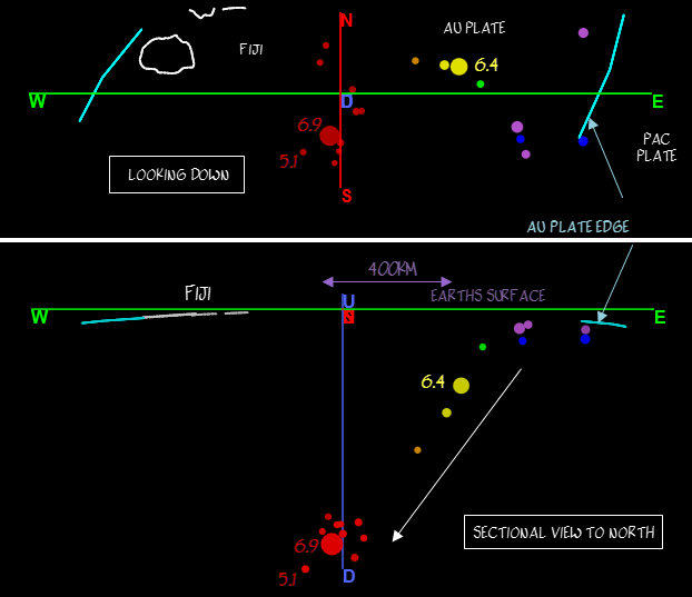
* Note. I especially turned off Ad Block Plus to load the images twice today. I don't know how you guys that don't have it can stand all the junk on the pages.
Re Fiji/Tonga today
its simply the Pacific Plate slipping under the Australian Plate, there are no "Faults" involved, the whole PacPlate just slipped under to the west a millimetre or so suddenly.
check out the depths, the 1st one at 185km (M6.4) and the 2nd one at 591km (M6.9), 3rd one at 605km (M5.1)
* Note. I especially turned off Ad Block Plus to load the images twice today. I don't know how you guys that don't have it can stand all the junk on the pages.
edit on 0900000026726716 by muzzy because: (no reason given)
Just 3 minutes after the Fiji 6.9 there was a countrywide series of light-moderate quakes right across both islands of New Zealand over a period of
less than 60 seconds
Mag, TimeUTC, Lat, Long, Depth, Location
4.12, 24/09/2016 21:32:06, -37.99492, 177.2542, 105.31km, Opotiki
4.25, 24/09/2016 21:32:19, -39.22507, 175.628, 95.94km, Tongaririo Crossing
4.23, 24/09/2016 21:32:46, -41.63729, 172.94908, 85.63km, NW of St Arnaud
NZ Topo Map shows them all, and a couple of the Sth of Kermadec ones too
It will be interesting to see if these were ghosts or replicas's of the big quake or were for real, they were not as deep as the Fiji ones but not shallow either, in relation to NZ section of the PacPlate subduction zone.
The Opotiki one says 3.9 on the Geonet link, but I downloaded the data after that number was put up on their web page
None of these were reported felt, because of the depth I guess
5.0 WSW of Gold Beach, Oregon.
earthquake.usgs.gov...
Cascadia wants to get in the mix of things. Haven't seen anything this big in this area for some time.
earthquake.usgs.gov...-info
I was hoping Olivine would pop in and comment on this one.
earthquake.usgs.gov...
Cascadia wants to get in the mix of things. Haven't seen anything this big in this area for some time.
earthquake.usgs.gov...-info
I was hoping Olivine would pop in and comment on this one.
edit on 25-9-2016 by crappiekat because: to add link
a reply to: crappiekat
Another one just popped off.
4.6 W of Brookings, Oregon.
earthquake.usgs.gov...
Are these foreshocks of something bigger, or just an adjustment.
earthquake.usgs.gov...
Another one just popped off.
4.6 W of Brookings, Oregon.
earthquake.usgs.gov...
Are these foreshocks of something bigger, or just an adjustment.
earthquake.usgs.gov...
edit on 25-9-2016 by crappiekat because: to add link
edit on
25-9-2016 by crappiekat because: to add
new topics
-
USO 10 miles west of caladesi island, Clearwater beach Florida
Aliens and UFOs: 3 hours ago
top topics
-
Anti-Israel Protesters in CHICAGO Chant 'Death to Israel and 'Death to America'
Social Issues and Civil Unrest: 15 hours ago, 15 flags -
Denver to Defund the Police 8.4 Million To Pay for Illegal Aliens
Social Issues and Civil Unrest: 17 hours ago, 14 flags -
Running Through Idiot Protestors Who Block The Road
Rant: 14 hours ago, 12 flags -
Report March 2024 - Underwater UFOs display capability that ‘jeopardizes US maritime security,’
Aliens and UFOs: 17 hours ago, 6 flags -
Tesla cutting 14,000 jobs
Global Meltdown: 12 hours ago, 6 flags -
USO 10 miles west of caladesi island, Clearwater beach Florida
Aliens and UFOs: 3 hours ago, 6 flags -
Israel ufo shoot down drones?
Aliens and UFOs: 12 hours ago, 5 flags -
Abortions in first 12 weeks should be legalised in Germany, commission says
Medical Issues & Conspiracies: 12 hours ago, 5 flags -
On this Day in History, April 15, 1865, Abraham Lincoln Passed Away.
General Chit Chat: 12 hours ago, 4 flags -
Negotiations and Diplomacy.
History: 16 hours ago, 0 flags
active topics
-
Mandela Effect - It Happened to Me!
The Gray Area • 98 • : BeTheGoddess2 -
The Truth About Jesus
Conspiracies in Religions • 265 • : glend -
J Balvin Columbian Singer captured this Triangle UFO footage…….
Aliens and UFOs • 13 • : magicai -
Another whistleblower: Rear Admiral Tim Gallaudet
Aliens and UFOs • 27 • : Ophiuchus1 -
Terrifying Encounters With The Black Eyed Kids
Paranormal Studies • 36 • : Consvoli -
Abortions in first 12 weeks should be legalised in Germany, commission says
Medical Issues & Conspiracies • 9 • : Vermilion -
Running Through Idiot Protestors Who Block The Road
Rant • 45 • : glen200376 -
The Reality of the Laser
Military Projects • 27 • : Zaphod58 -
Israel ufo shoot down drones?
Aliens and UFOs • 17 • : Zaphod58 -
Tesla cutting 14,000 jobs
Global Meltdown • 43 • : Vermilion