It looks like you're using an Ad Blocker.
Please white-list or disable AboveTopSecret.com in your ad-blocking tool.
Thank you.
Some features of ATS will be disabled while you continue to use an ad-blocker.

Quake Watch 2014
page: 66share:
a reply to: BobAthome
Thanks I hadn't seen that yet!
Things that make you go hmmm.....!
I wonder if there have been any die offs around that area?
You would think that something going into the ocean suddenly,
or the rising of a volcano, would have the opposite effect...
raising levels first, then normalizing again.
If there was a drop in the ocean floor somewhere,
big enough to move that much water, it would have sloshed back.
But would it have returned to normal height or been lower than before?
Something is definitely perking somewhere!!!
Guess we'll have to wait to see what it is.
WOQ
a reply to: wasobservingquietly
to much activity on the same time and wrong places.....
i ágree... **something is stirring***
to much activity on the same time and wrong places.....
i ágree... **something is stirring***
Does anyone feel this guys theories have any merit?
Mr Nabhan lists the plain spoken reasons how and why it should be realized that it is plausible, with some degree of accuracy, to forecast the next ground-shaking catastrophe.
Mr Nabhan says that there has never been a new idea in science that wasn’t accepted without a fight and claims the next earthquake will happen on July 12 and September 9, between 4:45 to 7:55 a.m. or p.m.
In his book, Mr Nabhan lists every tremor powerful enough to have caused fatalities within a 70 mile radius of Los Angeles' city center, struck Southern California between 1933 and 1994.
He states that every one of them occurred either within a tight 3 hour window at dawn or a corresponding time interval at dusk.
Two thirds of those events also took place not only either at dawn or dusk, but within 36 hours of the precise instant of new or full moon phases.
Read more: www.dailymail.co.uk...
Follow us: @MailOnline on Twitter | DailyMail on Facebook
I just saw Alaska come through. It looked bigger than 5.7, but what do I know. I was beginning to think I was watching the Alaskan webicorders for
nothing. It's still not the large one I think is due. Also, it's not in the usual location. Of course, this area gets earthquakes, it's just that
compare to the other nearby zones, this area is further southeast. Also, also, that swarm way up in the north is ongoing.
The other day I was so bored because watching Yellowstone was like watching paint flake. But now it's popping off in the location of the last majorish swarm up just to the west of Norris. Norris is clearly subsiding. So, it arose very quickly, popped off tons of little quakes, and then fell just as quickly as it had risen. Hmmm. And I'm sure this latest series has nothing to do with Alaska. Maybe. Research 7.9 M Alaskan earthquake changes Yellowstone's geysers.
I am trying the EMSC to watch. It doesn't post Yellowstone. There were other quakes I saw that it misses. Oh well, I'll just keeping watching the squigglies and cross referencing. Charlie Brown groan.
I was going to post about the Moon theory guy. But didn't. When I looked up the San Fran earthquake of 1906, I found the moon was not full or new. I believe heavy rains that in the area was in part a trigger. The moon does help trigger earthquakes, but only a small percentage. There are many factors working together that determine the level of stress and the conditions under which it will rupture. Like when you pump millions of gallons of water directly underneath them, they tend be be more active. Or, after a long drought breaks, earthquakes will follow. There's a Chinese study.
nuff
nope
also a Alaskan volcano erupting.
www.volcanodiscovery.com...
edit on 4-6-2014 by ericblair4891 because: (no reason given)
2014-06-05 05:44:31 5.1 61.31°N 140.44°W 10 Southern Yukon Territory, Canada
2014-06-05 05:38:03 5.1 61.34°N 140.47°W 10 Southern Yukon Territory, Canada
geofon.gfz-potsdam.de...
only the second one confirmed by EQ Canada
Date Time (UT) Lat Lon Depth Mag Felt? Region
2014/06/05 05:44:29 61.15 -140.27 1.4 5.2 Yes 154 km W of Haines Jct.,YT.
www.earthquakescanada.nrcan.gc.ca...
USGS not so Useless on this one; (latest at top)
2.6 152km WNW of Haines Junction, Canada 2014-06-05 15:24:16 UTC 0.1 km
2.8 159km WNW of Haines Junction, Canada 2014-06-05 06:55:49 UTC 0.0 km
2.8 161km WNW of Haines Junction, Canada 2014-06-05 06:55:20 UTC 20.4 km
2.8 160km WNW of Haines Junction, Canada 2014-06-05 06:28:17 UTC 0.0 km
2.8 155km WNW of Haines Junction, Canada 2014-06-05 05:51:27 UTC 0.7 km
5.2 162km WNW of Haines Junction, Canada 2014-06-05 05:44:27 UTC 9.5 km
4.9 142km WNW of Haines Junction, Canada 2014-06-05 05:37:59 UTC 11.8 km
you know where to go, link is too long to work here
edit on 0600000015515514 by muzzy because: (no reason given)
USGS depths, if correct, show some of those may have broken the surface, closer inspection on one of those 0.0km depths shows "± 0.2 km"
edit
on 06u15515514 by muzzy because: (no reason given)
Just felt this one 10 minutes ago. Was standing next to MsMuzzy who was sitting at the computer, me giving instructions on setting column widths in
Excel ( as one does on a Friday late afternoon!) and suddenly she jumped out of her skin, WTF?? then she pointed to the CD disc stand and the green
indoor plants shaking, then I felt it, quite wobbly it was, went on for 30 seconds or so. Interesting standing up i probably wouldn't have noticed it,
but she sitting felt it right away
4520 felt reports already!!
www.geonet.org.nz...
Public ID 2014p422047
Universal Time June 6 2014 at 3:46:56
NZ Standard Time Friday, June 6 2014 at 3:46:56 pm
Latitude, Longitude -39.49, 175.24
Intensity ? moderate
Focal Depth 76 km
Magnitude 5.1
Location 20 km west of Ohakune
4520 felt reports already!!
www.geonet.org.nz...
edit on 06u15515514 by muzzy because: (no reason given)
a reply to: muzzy
What do you think of this one Muzzy, I follow NZ herald on facebook so the news article on the quake was linked and they put:
If its smack bang in the center of the NI, can it even be a subduction event? scuse'my ignorance, but I thought they were more off the coast? Or is that why they have the active volcanoes not far away? (I feel like i just answered my own question there) Either way, to have felt reports from Auckland to Blenheim, to Hawkes bay to new plymouth is pretty bloody far isn't it? Seems a bit unusual too?
oddly enough (for me, anyway) I was looking at holiday homes in Ohakune on Tuesday. Doing a North Island road trip next March/April.
What do you think of this one Muzzy, I follow NZ herald on facebook so the news article on the quake was linked and they put:
GeoNet said the quake struck at a depth of 76km. It was a "subduction zone event" so was felt quite far afield, the organisation said.
If its smack bang in the center of the NI, can it even be a subduction event? scuse'my ignorance, but I thought they were more off the coast? Or is that why they have the active volcanoes not far away? (I feel like i just answered my own question there) Either way, to have felt reports from Auckland to Blenheim, to Hawkes bay to new plymouth is pretty bloody far isn't it? Seems a bit unusual too?
oddly enough (for me, anyway) I was looking at holiday homes in Ohakune on Tuesday. Doing a North Island road trip next March/April.
a reply to: bkaust
yeah the Plates overlap that far in, all the way to a line through Hawera/ Stratford/ north of the Volcanic Plateau/Tauranga if you go by the depth maps
Au Plate shifting slowly east , its only 900 years since Mt. Taranaki erupted, must be off the hot spot now, although there are still hot springs deep below New Plymouth.
ETA:
yeah pretty rare, I only got 7 events above M5 since 1840 between Mt Ruapehu and Wanganui (todays area)
map 5 of the 7 were deeper than 90km
BTW that 5.1 today been relocated to 103km deep.
i wonder of this is related to those 5 deep quakes offshore of the West Coast of the NI on 02.06.2014?, if you believe in subduction, those would be the edge of the Pacific Plate dropping off into the mantle, and todays the result of the springback due to the loss of mass along there. Could have popped anywhere along the 100km depth mark (blue icons on the depth map I linked to above) but found the weakest part?
edit on 0600000015615614 by muzzy because: (no reason given)
a reply to: Char-Lee
From the article
Regrettably in this instance I have to agree with them.
Just another quack sucking in the media. Muzzy did quite a protracted study on this and found no reasonable correlation. Neither did I.
From the article
Earthquake prediction has been almost a taboo field of study for the United States Geological Survey and say such findings are nonsense
Regrettably in this instance I have to agree with them.
Just another quack sucking in the media. Muzzy did quite a protracted study on this and found no reasonable correlation. Neither did I.
a reply to: PuterMan
Thanks for the response.
This little article i was reading this morning, do you agree also that is is normal stuff? Thanks.
www.oregonlive.com...
Thanks for the response.
This little article i was reading this morning, do you agree also that is is normal stuff? Thanks.
The University of Utah Seismograph Station reported five small earthquakes including those with magnitudes of 3.4, 2.7 and 3.2 in a 20-minute period starting at 3:33 a.m. in an area 16 to 18 miles south of Gardiner.
www.oregonlive.com...
further to post by: muzzy
This quake was located just south of the Waipuna Fault running West/East, which follows the Kaukore Stream on its Western end
but may be on an extension of the Oruakukuru Fault which runs the same way and in line with the quake location but stops before it.
Who knows? at 100km depth neither of these faults may be involved, they are not major faults, but offshoots of the Karioi Fault, which in itself is not a major fault either, but part of the fault system surrounding the Volcanic Plateau.
Waipuna Fault
Oruakukuru Fault
ETA: I've KMZ'd (tracked) the Faults with GPS Visualiser, and put it with the quake location map here
edit
on 06u15615614 by muzzy because: add another map link
earthquake.usgs.gov...
M6.0 - 45km ENE of Noatak, Alaska
2014-06-07 04:43:36 UTC
Event Time
2014-06-07 04:43:36 UTC
2014-06-06 20:43:36 UTC-08:00 at epicenter
2014-06-06 21:43:36 UTC-07:00 system time
Location
67.747°N 161.985°W depth=14.3km (8.9mi)
Nearby Cities
45km (28mi) ENE of Noatak, Alaska
711km (442mi) WNW of College, Alaska
715km (444mi) WNW of Fairbanks, Alaska
725km (450mi) WNW of Badger, Alaska
1505km (935mi) NW of Whitehorse, Canada
a reply to: dreamfox1
overestimated again by Useless
5.7mb, 5.5ML
ever notice on USGS that it takes them forever to put up Mw and Moment Tensors for American quakes
compared to overseas that is
overestimated again by Useless
5.7mb, 5.5ML
ever notice on USGS that it takes them forever to put up Mw and Moment Tensors for American quakes
compared to overseas that is
swarm off Oman
2014-06-07 04:19:36, 4.7, 14.62°N, 54.82°E, 10 , Owen Fracture Zone Region
2014-06-06 15:31:12, 4.7, 14.62°N, 54.75°E, 10 , Owen Fracture Zone Region
2014-06-06 03:43:57, 4.5, 14.71°N, 54.86°E, 10 , Owen Fracture Zone Region
2014-06-06 03:38:29, 4.7, 14.67°N, 54.68°E, 10 , Owen Fracture Zone Region
2014-06-06 02:55:47, 4.4, 14.67°N, 54.36°E, 10 , Owen Fracture Zone Region
geofon.gfz-potsdam.de...
a reply to: muzzy
5.7Mwb in the end
earthquake.usgs.gov...-tensor
looks like Noatak has been building up for a while
text list 30 days
or its just plain active, 2 other M5.5's in the last 12 months
text list 12 months
not much size wise before the first one of those M5.5's on 2014-04-18 18:44:18 UTC
text list since 1990
data from IRIS using custom queries and using the map
So, the data seems to show that there is no correlation between solar activity and earthquakes.
USGS blog May 2013
Remember how prior to the Tohoku earthquake in 2011, there was a spike in the 10.7 cm radio solar flux values on March 7th (938.6 observed sfu)? This was due to an M3 flare, which also generated a very fast moving coronal mass ejection, that gave earth a glancing blow at 0630 UTC on March 10th. source
Maybe those solar events and the mag 9.0 were coincidental. Or maybe, some solar activity can prompt earthquakes, and some doesn't.
Well, today at 11:42 UTC there was an impulsive X2.2 solar flare which produced a 10.7 type II radio burst lasting 3 minutes, measuring 1400 sfu. There was an associated small plasma ejection, but it is not earth directed.
It was followed an hour later by a slow emerging, but strong X1.5 flare, which generated a type IV, 18 minute radio burst lasting 18 minutes & measuring 530 solar flux units. Find up-to-date info at solar ham
I also want to note that there was a coronal hole in the middle of the sun a few days ago, which should blast the earth with solar wind by June 12th.
Image
I'll be watching the seismos with curiosity over the next few days, to see if anything large pops off.
Scientists assembled historical records of the Sun’s interaction with Earth, looking at sunspots, solar wind, and magnetic storms. They then compared these with historical records of earthquake occurrence. They found no significant pattern between solar activity and more or larger earthquakes.
USGS blog May 2013
Remember how prior to the Tohoku earthquake in 2011, there was a spike in the 10.7 cm radio solar flux values on March 7th (938.6 observed sfu)? This was due to an M3 flare, which also generated a very fast moving coronal mass ejection, that gave earth a glancing blow at 0630 UTC on March 10th. source
Maybe those solar events and the mag 9.0 were coincidental. Or maybe, some solar activity can prompt earthquakes, and some doesn't.
Well, today at 11:42 UTC there was an impulsive X2.2 solar flare which produced a 10.7 type II radio burst lasting 3 minutes, measuring 1400 sfu. There was an associated small plasma ejection, but it is not earth directed.
It was followed an hour later by a slow emerging, but strong X1.5 flare, which generated a type IV, 18 minute radio burst lasting 18 minutes & measuring 530 solar flux units. Find up-to-date info at solar ham
I also want to note that there was a coronal hole in the middle of the sun a few days ago, which should blast the earth with solar wind by June 12th.
Image
I'll be watching the seismos with curiosity over the next few days, to see if anything large pops off.
While things are quiet.................
big upgrade on NZ Earthquakes blog
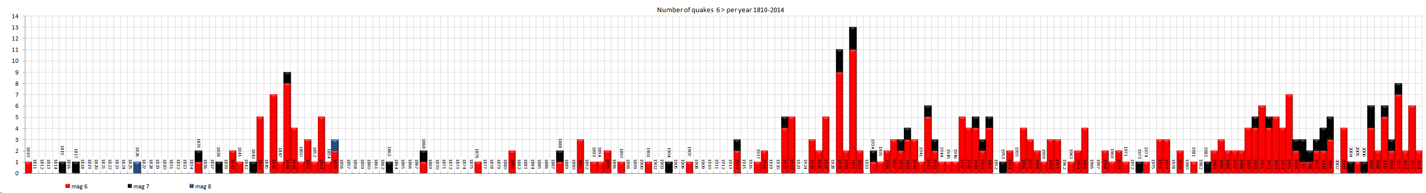
I have brought over from Blogger my historic NZ M5+ earthquake maps, made the maps interactive and gone back 204 years to 1810!
151 new maps!!
And found another M8
Ref: 2177651
Lat/Long: -45 167
Date/Time UTC: 1826/01/01 00:00:00
Depth: 25.0 km
Mag: 8 ML
Status: reviewed
Location: offshore Caswell Sound, Fiordland
Energy Released: 15,080,242.46 tonnes of TNT
heres the starting page
summary
1859 =mag5
284 = mag6
45 = mag7
2 = mag8
2190 = total M5+
2 timeline/numbers graphs
this is the one that is important to see the trend, the M6+ one
 (click image for larger version, opens in new
tab/window)
(click image for larger version, opens in new
tab/window)
we have had a couple of rough years 2009-2014, but its still no where as bad as 1925-1932 (Napier)
1840-1855, 1942-1951 and 1989-2001 were pretty busy too.
so thanks to a post by: bkaust after that last M5, and the comment "Seems a bit unusual too? ". I had a heck of a job searching that area using Geonet's new web layout, the only way was to do a one degree square search, but that was spilling over offshore and had to be edited back.
Now one can go to this page and at a glance see the whole history of whatever area just by zooming around the map.
big upgrade on NZ Earthquakes blog
I have brought over from Blogger my historic NZ M5+ earthquake maps, made the maps interactive and gone back 204 years to 1810!
151 new maps!!
And found another M8
Ref: 2177651
Lat/Long: -45 167
Date/Time UTC: 1826/01/01 00:00:00
Depth: 25.0 km
Mag: 8 ML
Status: reviewed
Location: offshore Caswell Sound, Fiordland
Energy Released: 15,080,242.46 tonnes of TNT
heres the starting page
summary
1859 =mag5
284 = mag6
45 = mag7
2 = mag8
2190 = total M5+
2 timeline/numbers graphs
this is the one that is important to see the trend, the M6+ one

we have had a couple of rough years 2009-2014, but its still no where as bad as 1925-1932 (Napier)
1840-1855, 1942-1951 and 1989-2001 were pretty busy too.
so thanks to a post by: bkaust after that last M5, and the comment "Seems a bit unusual too? ". I had a heck of a job searching that area using Geonet's new web layout, the only way was to do a one degree square search, but that was spilling over offshore and had to be edited back.
Now one can go to this page and at a glance see the whole history of whatever area just by zooming around the map.
edit on 06u16016014 by muzzy because: well the inevitable spelling mistake, saquae, meant to be square
a reply to: Olivine
probably the same co-incidence as;
I buy a new (jap import 2nd hand) vehicle
I drive it for 8 months no problems.....
I put it for a service
less than a month later the alternator pulley fails
when I get that fixed, the central locking doesn't work
when that is fixed, the seatbelt light won't go out on the dash
the electricians says its just co-incidence
yeah right, a $1500 co-incidence
back on topic, they found the same thing I did when I did my study re flares/earthquakes ...... nothing stood out
edit on 06u16016014 by muzzy
because: (no reason given)
new topics
-
BIDEN Admin Begins Planning For January 2025 Transition to a New President - Today is 4.26.2024.
2024 Elections: 3 hours ago -
Big Storms
Fragile Earth: 4 hours ago -
Where should Trump hold his next rally
2024 Elections: 7 hours ago -
Shocking Number of Voters are Open to Committing Election Fraud
US Political Madness: 8 hours ago -
Gov Kristi Noem Shot and Killed "Less Than Worthless Dog" and a 'Smelly Goat
2024 Elections: 8 hours ago -
Falkville Robot-Man
Aliens and UFOs: 9 hours ago -
James O’Keefe: I have evidence that exposes the CIA, and it’s on camera.
Whistle Blowers and Leaked Documents: 9 hours ago -
Australian PM says the quiet part out loud - "free speech is a threat to democratic dicourse"...?!
New World Order: 10 hours ago -
Ireland VS Globalists
Social Issues and Civil Unrest: 11 hours ago -
Biden "Happy To Debate Trump"
2024 Elections: 11 hours ago
top topics
-
James O’Keefe: I have evidence that exposes the CIA, and it’s on camera.
Whistle Blowers and Leaked Documents: 9 hours ago, 17 flags -
Australian PM says the quiet part out loud - "free speech is a threat to democratic dicourse"...?!
New World Order: 10 hours ago, 15 flags -
Blast from the past: ATS Review Podcast, 2006: With All Three Amigos
Member PODcasts: 13 hours ago, 13 flags -
Biden "Happy To Debate Trump"
2024 Elections: 11 hours ago, 13 flags -
Ireland VS Globalists
Social Issues and Civil Unrest: 11 hours ago, 9 flags -
Mike Pinder The Moody Blues R.I.P.
Music: 13 hours ago, 8 flags -
BIDEN Admin Begins Planning For January 2025 Transition to a New President - Today is 4.26.2024.
2024 Elections: 3 hours ago, 7 flags -
What is the white pill?
Philosophy and Metaphysics: 13 hours ago, 6 flags -
Shocking Number of Voters are Open to Committing Election Fraud
US Political Madness: 8 hours ago, 6 flags -
Big Storms
Fragile Earth: 4 hours ago, 6 flags
active topics
-
Australian PM says the quiet part out loud - "free speech is a threat to democratic dicourse"...?!
New World Order • 7 • : 19Bones79 -
It takes One to Be; Two to Tango; Three to Create.
Philosophy and Metaphysics • 8 • : Compendium -
Big Storms
Fragile Earth • 16 • : rickymouse -
James O’Keefe: I have evidence that exposes the CIA, and it’s on camera.
Whistle Blowers and Leaked Documents • 14 • : 19Bones79 -
BIDEN Admin Begins Planning For January 2025 Transition to a New President - Today is 4.26.2024.
2024 Elections • 18 • : rickymouse -
RAAF airbase in Roswell, New Mexico is on fire
Aliens and UFOs • 12 • : pianopraze -
A Warning to America: 25 Ways the US is Being Destroyed
New World Order • 29 • : 19Bones79 -
What is the white pill?
Philosophy and Metaphysics • 22 • : AlexandrosOMegas -
University of Texas Instantly Shuts Down Anti Israel Protests
Education and Media • 315 • : CriticalStinker -
Gov Kristi Noem Shot and Killed "Less Than Worthless Dog" and a 'Smelly Goat
2024 Elections • 58 • : cherokeetroy