It looks like you're using an Ad Blocker.
Please white-list or disable AboveTopSecret.com in your ad-blocking tool.
Thank you.
Some features of ATS will be disabled while you continue to use an ad-blocker.

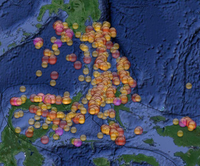
Quake Watch 2014
page: 100share:
originally posted by: muzzy
I wouldn't give it too much notice, although it is in the general area (278km)
the prediction was from Monday, January 7, 2013 - December 2014
almost 2 years span
its 1,344,028 TTNT(M7.3) versus 15,080,242 TTNT(M8.0)
massive difference
lets not hope its not a foreshock,
the 6.0 aftershock was quite a long way from the 7.3 (362.6km)which might mean this is a major fault about to break
plenty of history there (497 quakes above M5.5 since 1990)
goo.gl... (link good till Feb 2015 ........ apparently)
FYI data comes from Wilber3 ds.iris.edu...
.
.
[snip]
.
.
IRIS - what a great site. Thank you Muzzy.
Magnitude 4.2 - Kansas (480)
Location in Google Maps
- Date-Time: Saturday, November 15, 2014 @ 10:18:13 UTC
- Earthquake location: 37.208°N, 98.056°W,
- Earthquake depth: 7.7 km
- Distances:
6km (3mi) NNW of Anthony, Kansas
73km (45mi) WSW of Haysville, Kansas
79km (49mi) WSW of Derby, Kansas
83km (51mi) SW of Wichita, Kansas
199km (123mi) NNW of Oklahoma City, Oklahoma
- Event ID: usc000sxkz
Derived from Event Data Source: USGS
Powered by QVSData
Appears to be right in the middle of farmland with no immediate frack pads visible on 2013 imagery.
edit on 15/11/2014 by PuterMan because: (no reason given)
a reply to: pheonix358
But then again I did not say this was the event. That may still be to come if their prediction methods work.
But then again I did not say this was the event. That may still be to come if their prediction methods work.
a reply to: PuterMan
No, you didn't. I was replying to Doodle's post and obviously replied to the wrong post.
Sorry about that.
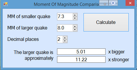
Time will tell. Thank you for the math answer, I could not do it in my head. Would you mind defining the terms 'Bigger' and 'stronger' for plebes like me please.
P
No, you didn't. I was replying to Doodle's post and obviously replied to the wrong post.
Sorry about that.
Time will tell. Thank you for the math answer, I could not do it in my head. Would you mind defining the terms 'Bigger' and 'stronger' for plebes like me please.
P
Felt this one down here on the Kapiti Coast!
Vibration, definitely knew it was an earthquake, probably wouldn't have felt it if not sitting down
Vibration, definitely knew it was an earthquake, probably wouldn't have felt it if not sitting down
Public ID 2014p864702
Intensity severe
Universal Time November 16 2014, 22:33:25
NZ Daylight Time Mon, Nov 17 2014, 11:33:25 am
Depth 49 km
Magnitude 6.2
Location 100 km east of Te Araroa
Latitude, Longitude -37.82, 179.48
Agency WEL(GNS_Primary)
www.geonet.org.nz...
edit on 1100000031931914 by muzzy because: (no reason given)
Eh? another one (may have been happening at the same time, a minute apart) S wave from the East Cape one still going when the P wave from Hamner
Springs hit???)
Wow wacked from both sides, no wonder we felt the ground move here in the middle, yeah it did go on for a while
Na h just SiesComp having a fit, this one has changed to a 6.1 East Cape now
could get dropped
was it 2 x M6's or just the equipment having a fit?
geez, now its one quake 6.5
www.geonet.org.nz...
GFZ
Wow wacked from both sides, no wonder we felt the ground move here in the middle, yeah it did go on for a while
Public ID 2014p864703
Intensity severe
Universal Time November 16 2014, 22:34:52
NZ Daylight Time Mon, Nov 17 2014, 11:34:52 am
Depth 6 km
Magnitude 5.1
Location 30 km east of Hanmer Springs
Latitude, Longitude -42.52, 173.17
Agency WEL(GNS_Primary)
www.geonet.org.nz...
edit on 11u31931914 by muzzy because: (no reason given)
edit on 11u31931914 by muzzy because: (no reason
given)
Na h just SiesComp having a fit, this one has changed to a 6.1 East Cape now
could get dropped
was it 2 x M6's or just the equipment having a fit?
edit on 11u31931914 by muzzy because: (no reason given)
geez, now its one quake 6.5
www.geonet.org.nz...
edit on 11u31931914 by muzzy because: (no reason given)
GFZ
F-E Region: Off E. Coast of N. Island, N.Z.
Time: 2014-11-16 22:33:21.0 UTC
Magnitude: 6.6
Epicenter: 179.49°E 37.58°S
Depth: 10 km
Status: A - automatic
geofon.gfz-potsdam.de...
edit on 11u31931914 by muzzy because: (no reason given)
87km east of the 1995 East Cape 6.99
The 1995 (February 5) Waitangi Day sequence, offshore East Cape, began with a magnitude 6.99 mainshock at 22:51:02 UTC at a depth of 12km and was followed by 696 aftershocks events 2.84 - 5.99ML within the first 24 hours of the main rupture.
This one is out the Pacific Plate according to initial Geonet co-ordinates ( reviewed) whereas the 1995 event was under the Australian Plate.
just doing some maps now, 10 aftershocks so far, all quite small
Date/Time UTC, Latitude, Longitude, Magnitude
16/11/2014 22:33:15, -37.5366, -179.5679, 6.639
16/11/2014 23:09:48, -37.6746, 179.9211, 3.45
16/11/2014 23:11:14, -37.652, 179.719, 3.60
16/11/2014 23:30:21, -37.4324, 179.6478, 3.22
16/11/2014 23:35:13, -37.575, 179.8173, 2.93
17/11/2014 00:03:33, -37.4314, 179.8446, 3.04
17/11/2014 00:32:24, -37.518, 179.8387, 3.24
17/11/2014 00:34:53, -37.536, 179.8295, 2.59
17/11/2014 02:37:38, -37.6605, 179.9496, 3.58
17/11/2014 03:06:18, -37.6958, 179.6398, 3.25
17/11/2014 03:55:52, -37.7145, 179.9185, 2.95
17/11/2014 04:10:08, -37.7072, 179.7907, 3.29
just ran those through GPS Visualiser, they are all in where the 1995 6.99 was, the 6.6 today is out there on its own, could be a faulty location, its early days yet
map after dinner (Stew)
here you go, I put the 3 x 1995 M6 quakes on it too
interactive map of todays 6.63ML East Cape quake and aftershocks to 5:35pm NZDT
The 1995 (February 5) Waitangi Day sequence, offshore East Cape, began with a magnitude 6.99 mainshock at 22:51:02 UTC at a depth of 12km and was followed by 696 aftershocks events 2.84 - 5.99ML within the first 24 hours of the main rupture.
This one is out the Pacific Plate according to initial Geonet co-ordinates ( reviewed) whereas the 1995 event was under the Australian Plate.
just doing some maps now, 10 aftershocks so far, all quite small
Date/Time UTC, Latitude, Longitude, Magnitude
16/11/2014 22:33:15, -37.5366, -179.5679, 6.639
16/11/2014 23:09:48, -37.6746, 179.9211, 3.45
16/11/2014 23:11:14, -37.652, 179.719, 3.60
16/11/2014 23:30:21, -37.4324, 179.6478, 3.22
16/11/2014 23:35:13, -37.575, 179.8173, 2.93
17/11/2014 00:03:33, -37.4314, 179.8446, 3.04
17/11/2014 00:32:24, -37.518, 179.8387, 3.24
17/11/2014 00:34:53, -37.536, 179.8295, 2.59
17/11/2014 02:37:38, -37.6605, 179.9496, 3.58
17/11/2014 03:06:18, -37.6958, 179.6398, 3.25
17/11/2014 03:55:52, -37.7145, 179.9185, 2.95
17/11/2014 04:10:08, -37.7072, 179.7907, 3.29
edit on 11u31931914 by muzzy because: commas
just ran those through GPS Visualiser, they are all in where the 1995 6.99 was, the 6.6 today is out there on its own, could be a faulty location, its early days yet
map after dinner (Stew)
edit on 1100000031931914 by muzzy because: (no reason given)
here you go, I put the 3 x 1995 M6 quakes on it too
interactive map of todays 6.63ML East Cape quake and aftershocks to 5:35pm NZDT
edit on 1100000032032014
by muzzy because: (no reason given)
here is the latest map based on data from Geonet at 6am, 18 hours, 26 minutes and 45 seconds after the main shock
Not many aftershocks, only 19 in the data for the GL region known as East Cape Ridge Off NI N.Z.
that 3.87 and 4.14 to the north are 175km away from the main bunch of aftershocks and the main shock, so may not be directly related (aftershocks) as this area is pretty active all the time anyway.
interactive map of yesterdays 6.63ML East Cape quake and aftershocks to 6am 18th Nov NZDT
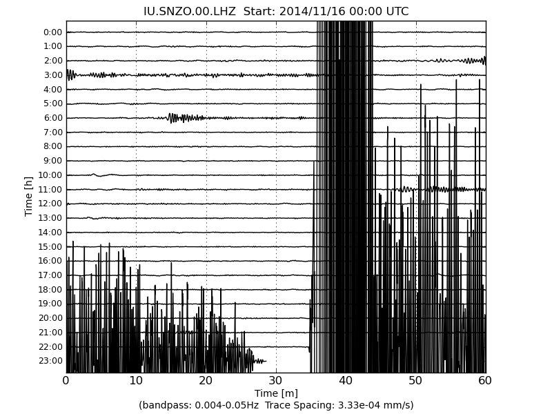
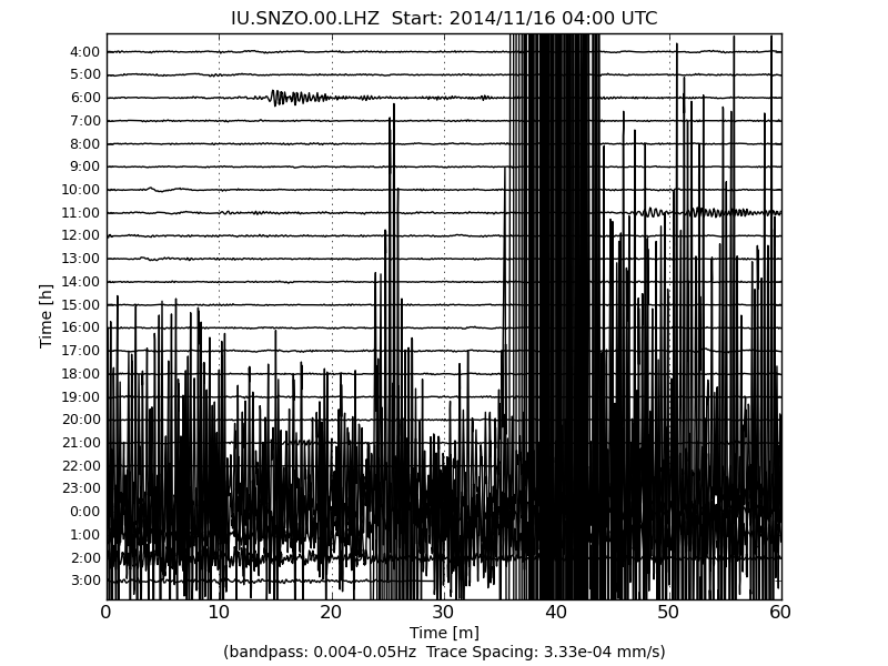
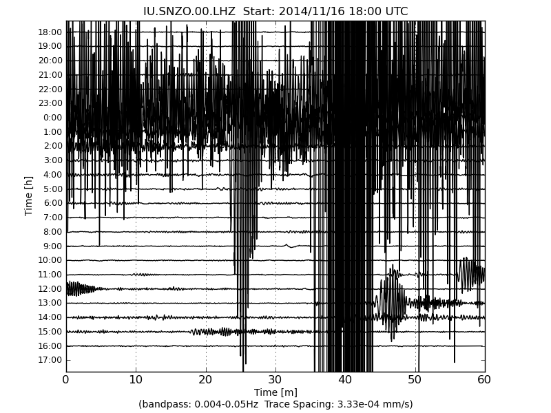
That 5.9 at the D'Entrecasteaux Islands west of the Solomon Is an hour and half later made a mess of our East Cape trace on LISS.
its the shorter skinnier one in the centre of the 2nd and 3rd graphs below
Not many aftershocks, only 19 in the data for the GL region known as East Cape Ridge Off NI N.Z.
that 3.87 and 4.14 to the north are 175km away from the main bunch of aftershocks and the main shock, so may not be directly related (aftershocks) as this area is pretty active all the time anyway.
interactive map of yesterdays 6.63ML East Cape quake and aftershocks to 6am 18th Nov NZDT
That 5.9 at the D'Entrecasteaux Islands west of the Solomon Is an hour and half later made a mess of our East Cape trace on LISS.
its the shorter skinnier one in the centre of the 2nd and 3rd graphs below
edit on 1100000032032014 by muzzy because: (no reason given)
Lots of ground movement
earthquake.usgs.gov...
earthquake.usgs.gov...
5.3
8km SSW of Limni, Greece
2014-11-17 15:09:04 UTC-08:0010.0 km
5.4
7km SW of Prokopion, Greece
2014-11-17 15:05:57 UTC-08:0013.2 km
earthquake.usgs.gov...
earthquake.usgs.gov...
5.3
8km SSW of Limni, Greece
2014-11-17 15:09:04 UTC-08:0010.0 km
5.4
7km SW of Prokopion, Greece
2014-11-17 15:05:57 UTC-08:0013.2 km
a reply to: dreamfox1
why don't they just say "North Euboean Gulf"
scheech at least everyone knows where that is
bbnet.gein.noa.gr...
why don't they just say "North Euboean Gulf"
scheech at least everyone knows where that is
bbnet.gein.noa.gr...
edit on 1100000032032014 by muzzy because:
(no reason given)
interactive map of yesterdays 6.63ML East Cape quake and aftershocks to 6pm 18th Nov NZDT
That 4.14 been downgraded to 3.97
summary
mag2= 7
mag3= 24
mag4= 1
mag5= 0
mag6= 1
total= 33
TTNT= 137,181.579
That 4.14 been downgraded to 3.97
summary
mag2= 7
mag3= 24
mag4= 1
mag5= 0
mag6= 1
total= 33
TTNT= 137,181.579
edit on 11u32132114 by muzzy because: (no reason given)
a reply to: pheonix358
Bigger refers to the amplitude of the seismic waves recorded at a seismograph station, in other words the effect on the arm of the seismograph if it was one like the LA drum we look at from time to time. The amount the needle swings back and forth.
Stronger refers to the amount of energy released.
Bigger refers to the amplitude of the seismic waves recorded at a seismograph station, in other words the effect on the arm of the seismograph if it was one like the LA drum we look at from time to time. The amount the needle swings back and forth.
Stronger refers to the amount of energy released.
a reply to: dreamfox1
Gee that is a really confusing set of times you have there for an event 2014-11-17 23:09:04 UTC. I guess this is courtesy of Useless who insist in showing quakes in local times when all should be in UTC. A quake in local time is completely meaningless unless you live there just as 15kmSouthe West of Little Puddlwick is meaningless unless you live there.
I guess the US is just peeved that the UK is the centre of the time bands despite the International Meridian Conference in 1884 to determine the prime meridian being held in Washington DC. Just to pay us back they insiston using local times and screwing up the order of dates
Then we have this odd quake here today
earthquake.usgs.gov...
M3.8
17km NW of Eutaw, Alabama
Event Time
2014-11-20 10:25:31 UTC
2014-11-20 04:25:31 UTC-06:00 at epicenter
2014-11-20 02:25:31 UTC-08:00 system time
Location
32.950°N 88.017°W depth=5.0km (3.1mi)
Nearby Cities
17km (11mi) NW of Eutaw, Alabama
50km (31mi) SW of Tuscaloosa, Alabama
51km (32mi) SW of Northport, Alabama
71km (44mi) SSE of Columbus, Mississippi
173km (107mi) WNW of Montgomery, Alabama
Magnitude 6.9 - Northern Molucca Sea (266)
Location in Google Maps
- Date-Time: Friday, November 21, 2014 @ 10:10:24 UTC
- Earthquake location: 2.100°N, 127.000°E,
- Earthquake depth: 10.0 km
- Distances:
119km (73mi) WNW of Tobelo, Indonesia
150km (93mi) NNW of Ternate, Indonesia
151km (93mi) NNW of Kota Ternate, Indonesia
214km (132mi) ENE of Bitung, Indonesia
1011km (628mi) SW of Koror Town, Palau
- Event ID: at00nfdw9c
Derived from Event Data Source: USGS
Powered by QVSData
6.5Mw at present got GFZ Potsdam
This is pretty much bang on top of the Mag 7+ so I guess you might call it an aftershock although it does not play by the 1 mad difference rules.
6.8Mw for EMSC
edit on 21/11/2014 by PuterMan because: (no reason
given)
Possible Mag 6 - China
www.emsc-csem.org...
Waiting more details
In on Useless as 5.8 mb (which is over 6 Mw)
earthquake.usgs.gov...
Looks as if there a re quite a number of houses within 10 miles of the epicentre. USGS giving it a Pager YELLOW now. Intensity Mercalli VI
www.emsc-csem.org...
Waiting more details
In on Useless as 5.8 mb (which is over 6 Mw)
earthquake.usgs.gov...
Looks as if there a re quite a number of houses within 10 miles of the epicentre. USGS giving it a Pager YELLOW now. Intensity Mercalli VI
Green alert level for shaking-related fatalities. There is a low likelihood of casualties.
Yellow alert level for economic losses. Some damage is possible and the impact should be relatively localized. Estimated economic losses are less than 1% of GDP of China. Past events with this alert level have required a local or regional level response.
edit on 22/11/2014 by PuterMan because: (no reason given)
Announcement
Google has decided to upgrade the interactive mapping system of Google Maps, from Feb 2015 all my maps will go blank. It has to do with the use of KMZ files which are used to create the maps, it will no longer be supported.
This really pisses me off as I have spent the last 3 years building an archive of interactive earthquake maps, initially for New Zealand, daily/monthly/yearly, but also on EQArchives, a selection of countries on a monthly basis.
The EQArchives pages/maps are a problem, not only is KMZ not going to be supported, there is also a limit on how many events/items/icons one can use on each map
therefore any map with more than 500 events cannot be re created.
So that is the end of USA, Greece, Turkey, NZ, Japan, China etc etc monthly maps as they all have over 500 events on them (the USA has over 5000 earthquakes a month, which I had mapped, but even breaking it down to weekly it still wouldn't work)
Unless they change back to Classic Maps or offer it as an option, or come up with a way to display KMZ files, that is 3 years work down the drain!
I had a look at my Stats and notice some pages that I thought would be popular actually had buggerall readers, such as Turkey, Yellowstone, Mexico, Iceland, L'Aquila etc.
L'Aquila maps really surprised me, only 18 reads, I spent weeks on that to provide a comprehensive series of maps on the whole episode, I thought a lot of people would be interested in that especially afterthe coverage of the Court proceedings agains the geologists in the media. Appears not so.
USA readership is also quite low, only 11 reads of the 2014 year!
Really, I think I have been wasting my time.
I may redo my M7+ pages as I have put a lot of time into that, none of the maps have anywhere near 500 events on them, so they are re-doable, but I might just dump EQArchives altogether.
I have looked into various other mapping systems as alternatives to Googles, but none of them allow importation of KMZ files or if they do allow CSV files importation, its too complcated for me to understand how to use it.
So say goodbye to Mr.Aftershock, it was fun while it lasted.
I will continue to do the New Zealand maps using the new MyPlaces system, and may back track and "upgrade" the old maps back to as far as possible, its going to be a lot of work.
new topics
-
What is the white pill?
Philosophy and Metaphysics: 1 hours ago -
Mike Pinder The Moody Blues R.I.P.
Music: 2 hours ago -
Putin, Russia and the Great Architects of the Universe
ATS Skunk Works: 5 hours ago -
A Warning to America: 25 Ways the US is Being Destroyed
New World Order: 9 hours ago
top topics
-
President BIDEN's FBI Raided Donald Trump's Florida Home for OBAMA-NORTH KOREA Documents.
Political Conspiracies: 15 hours ago, 34 flags -
A Warning to America: 25 Ways the US is Being Destroyed
New World Order: 9 hours ago, 18 flags -
Mike Pinder The Moody Blues R.I.P.
Music: 2 hours ago, 5 flags -
Is AI Better Than the Hollywood Elite?
Movies: 17 hours ago, 4 flags -
What is the white pill?
Philosophy and Metaphysics: 1 hours ago, 4 flags -
Putin, Russia and the Great Architects of the Universe
ATS Skunk Works: 5 hours ago, 2 flags -
Maestro Benedetto
Literature: 16 hours ago, 1 flags
active topics
-
God's Righteousness is Greater than Our Wrath
Religion, Faith, And Theology • 34 • : andy06shake -
A Warning to America: 25 Ways the US is Being Destroyed
New World Order • 22 • : charlest2 -
Las Vegas UFO Spotting Teen Traumatized by Demon Creature in Backyard
Aliens and UFOs • 14 • : pianopraze -
Gaza Terrorists Attack US Humanitarian Pier During Construction
Middle East Issues • 73 • : FlyersFan -
SETI chief says US has no evidence for alien technology. 'And we never have'
Aliens and UFOs • 76 • : andy06shake -
Russia Ukraine Update Thread - part 3
World War Three • 5734 • : Arbitrageur -
So this is what Hamas considers 'freedom fighting' ...
War On Terrorism • 264 • : FlyersFan -
Candidate TRUMP Now Has Crazy Judge JUAN MERCHAN After Him - The Stormy Daniels Hush-Money Case.
Political Conspiracies • 792 • : Threadbarer -
What is the white pill?
Philosophy and Metaphysics • 6 • : kwaka -
Putin, Russia and the Great Architects of the Universe
ATS Skunk Works • 19 • : FlyersFan