It looks like you're using an Ad Blocker.
Please white-list or disable AboveTopSecret.com in your ad-blocking tool.
Thank you.
Some features of ATS will be disabled while you continue to use an ad-blocker.

Quake Watch 2014
page: 99share:
a reply to: wasobservingquietly
Yup another stunning example of their stupid 'locations love affair'. I have said it before but, these are OK if you are a local otherwise they are useless. If I said there was an earthquake 95km SE of Garahill would that mean anything to anyone? No, not even to people who live 50 miles from there. (It is Ireland of course)
My program converts (optionally) all locations to the FE nomenclature
2014-11-11 01:30:17, 66.461, -142.602, 3.2, 34.4 Nthn Alaska (676)
There have been a few small quakes in the Mount Lassen area of California. Could those be related to the swarm in Nevada?
USGS
M2.9 - 24km WNW of Chester, California
2014-11-11 11:12:57 UTC
ETA:
There was also a swarm in the Lassen area during the month of October:
USGS Volcanoes
USGS
M2.9 - 24km WNW of Chester, California
2014-11-11 11:12:57 UTC
ETA:
There was also a swarm in the Lassen area during the month of October:
Lassen Volcanic Center: A modest swarm of low-magnitude earthquakes occurred about 25 miles NW of the town of Chester on October 3-12. There were close to 10 earthquakes of M1.0 or greater, with the largest registering M2.1.
USGS Volcanoes
edit on 11-11-2014 by Jennyfrenzy because: eta
EMSC
Magnitude M 5.4
Region KANSAS
Date time 2014-11-12 21:40:00.6 UTC
Location 37.39 N ; 97.47 W
Depth 10 km
Distances 515 km N of Dallas, United States / pop: 1,197,816 / local time: 15:40:00.6 2014-11-12
213 km N of Oklahoma City, United States / pop: 579,999 / local time: 15:40:00.6 2014-11-12
16 km NW of Wellington, United States / pop: 8,172 / local time: 15:40:00.6 2014-11-12
I don't know where they came up with these locations?? Closer to Wichita Kansas, jeesh. Not even on USGS yet
4.8 on USGS now and now 4.8 for EMSC
Gotta love the comments/testimonies for these though...
looks like this was felt for quite some distance Savannah Georgia?
Magnitude M 5.4
Region KANSAS
Date time 2014-11-12 21:40:00.6 UTC
Location 37.39 N ; 97.47 W
Depth 10 km
Distances 515 km N of Dallas, United States / pop: 1,197,816 / local time: 15:40:00.6 2014-11-12
213 km N of Oklahoma City, United States / pop: 579,999 / local time: 15:40:00.6 2014-11-12
16 km NW of Wellington, United States / pop: 8,172 / local time: 15:40:00.6 2014-11-12
I don't know where they came up with these locations?? Closer to Wichita Kansas, jeesh. Not even on USGS yet
4.8 on USGS now and now 4.8 for EMSC
Gotta love the comments/testimonies for these though...
We thought a "heavy" person walked by with a cart full of computers causing the shelves and cube walls to shake. Got up and there was no heavy person there.
seemed like everything was swaying.....my daughter was laying in bed (a very heavy bed) and i was in an overstuffed chair. It felt to me that a cat was sharpening his claws on the back of the chair but no cat was there or sound
looks like this was felt for quite some distance Savannah Georgia?
edit on 11/12/2014 by whatnext21 because: (no reason given)
edit on 11/12/2014 by whatnext21 because: (no reason
given)
edit on 11/12/2014 by whatnext21 because: (no reason given)
originally posted by: whatnext21
EMSC
Magnitude M 5.4
Region KANSAS
Date time 2014-11-12 21:40:00.6 UTC
Location 37.39 N ; 97.47 W
Depth 10 km
Distances 515 km N of Dallas, United States / pop: 1,197,816 / local time: 15:40:00.6 2014-11-12
213 km N of Oklahoma City, United States / pop: 579,999 / local time: 15:40:00.6 2014-11-12
16 km NW of Wellington, United States / pop: 8,172 / local time: 15:40:00.6 2014-11-12
I don't know where they came up with these locations?? Closer to Wichita Kansas, jeesh. Not even on USGS yet
4.8 on USGS now
Area is in danger for a bigger one.
A wee quakie in bonny Scotland
2014-11-13 09:23:38, 55.800, -3.210, 2.2, 4.0 Scotland. United Kingdom
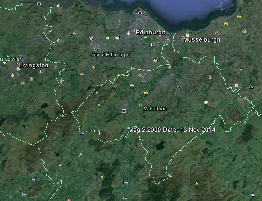
From the text below you can see that it is rare which was my immediate thought when it popped up.
The code I use for creating the Google Maps link does not seem to show anything now. The location should be in the middle of the screen. Muzzy, any ideas on how to deal with what they have obviously changed? The numpties can't leave anything alone!
2014-11-13 09:23:38, 55.800, -3.210, 2.2, 4.0 Scotland. United Kingdom
From the text below you can see that it is rare which was my immediate thought when it popped up.
At this time the BGS have received a single report from the area of this event being felt. It described "a weak trembling" and "effect was like somebody jumping on the roof".
This is the largest earthquake detected in the region since a magnitude 2.3 event on 9 December 2007 which was felt, in the Penicuik area, with a intensity of 3 EMS. There was also another magnitude 2.3 event detected around three weeks earlier (30 November 2007), which was also felt in the region with a similar intensity.
Updated 13 November 2014 11:30 UTC.
The code I use for creating the Google Maps link does not seem to show anything now. The location should be in the middle of the screen. Muzzy, any ideas on how to deal with what they have obviously changed? The numpties can't leave anything alone!
edit on 13/11/2014 by PuterMan because: To add location image
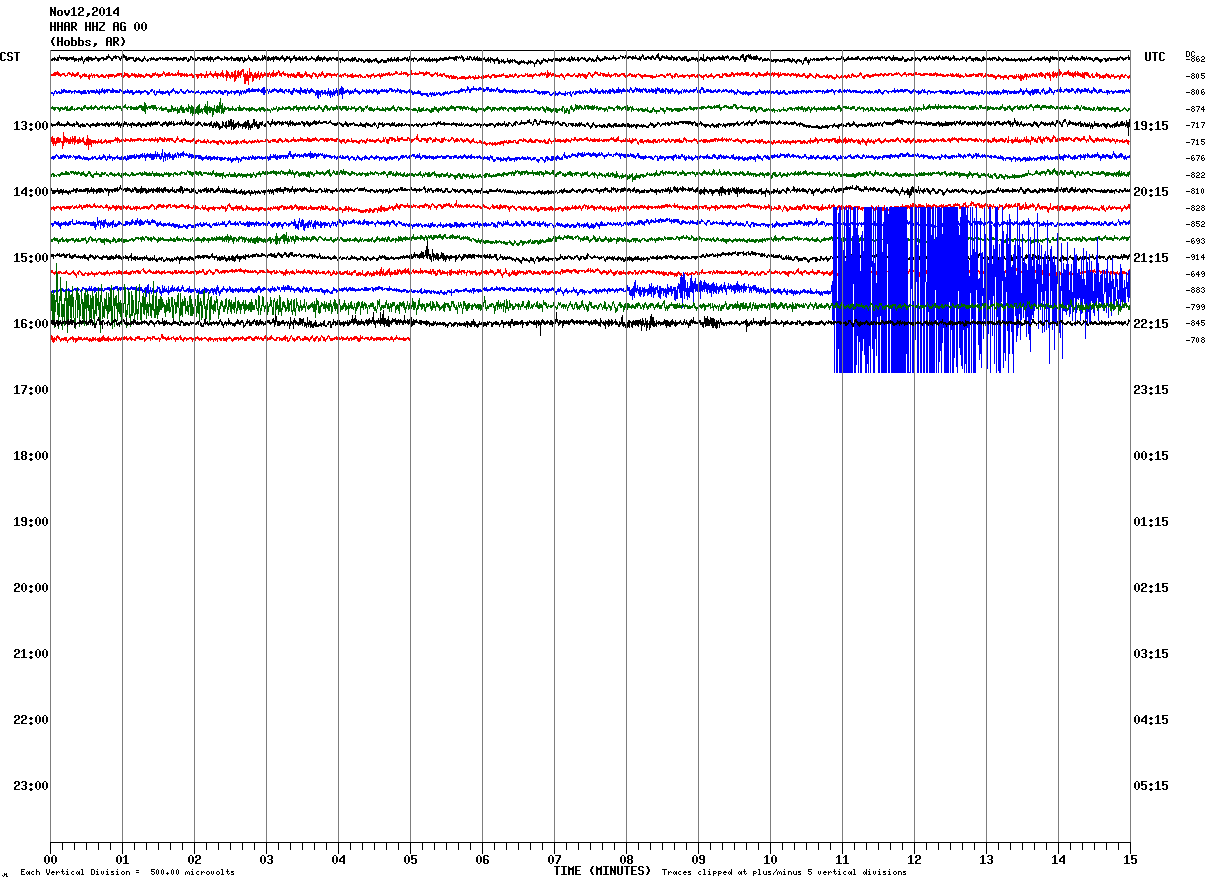
a reply to: ericblair4891
Looks a cracker on BCOK.OK
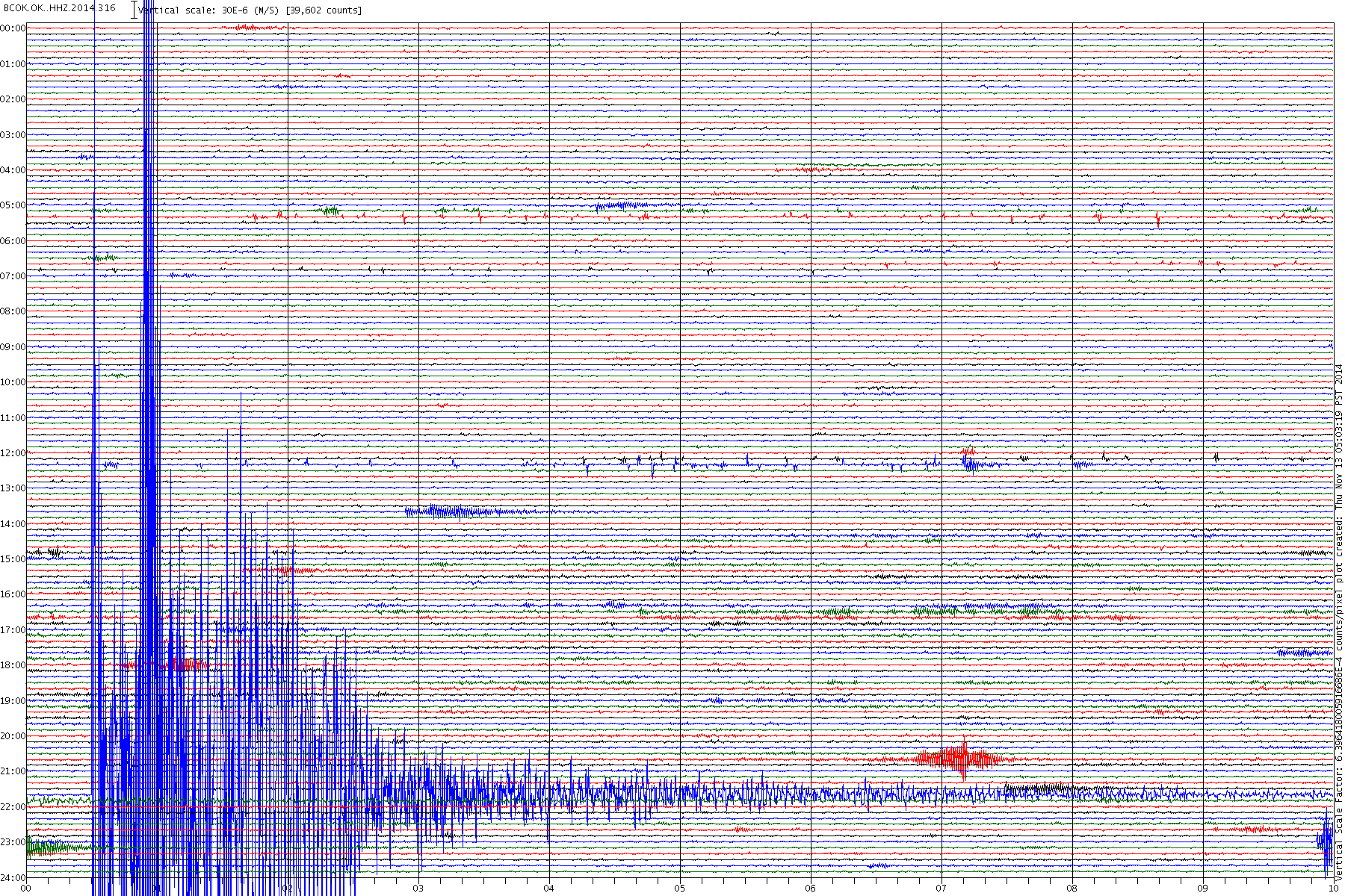
Click the image to enlarge
Any particular reason why you say mad made?
Looks a cracker on BCOK.OK

Click the image to enlarge
Any particular reason why you say mad made?
It appears that NW Nevada is still not settled down. The shaking continues.
Magnitude: 4.6 ml ± 0.31
Location: 41.901°N, 119.622°W ± 4.4 km
Depth: 0.0 km ± 3.4 km
Number of Stations Used: 7
Number of Phases Used: 10
Minimum Distance: 56.4 km (0.51°)
Travel Time Residual: 0.0742 sec
Azimuthal Gap: 81°
Review Status: MANUAL
Event ID: nn00467620
So long . . . and thanks for all the fish!
Bishop
F-E Region: Fiji Islands Region
Time: 2014-11-13 10:24:18.8 UTC
Magnitude: 6.0 (Mw)
Epicenter: 173.10°E 15.22°S
Depth: 10 km
Status: M - manually revised
geofon.gfz-potsdam.de...
Quite rare, between Vanuatu and Fiji, I think there was anothe M6 earlier this year there too
a reply to: muzzy
Yes EMSC have this as a 6 as ell but USGS still have it as 5.7mb which does not quite make it to 6.0 Mw
Iceland:
Still popping off bigger quakes in the caldera but this last one is way off course compared to the others.
Yes EMSC have this as a 6 as ell but USGS still have it as 5.7mb which does not quite make it to 6.0 Mw
Iceland:
Still popping off bigger quakes in the caldera but this last one is way off course compared to the others.
Prov,Date/Time UTC,Latitude,Longitude,Magnitude,Depth(Km),Location
emsc,2014-11-14 11:25:52, 64.680, -16.640, 5.2, 2.0, Iceland
emsc,2014-11-13 23:08:48, 64.660, -17.610, 4.6, 5.0, Iceland
emsc,2014-11-13 20:46:21, 64.730, -17.580, 4.5, 10.0, Iceland
emsc,2014-11-13 01:18:29, 64.680, -17.880, 4.5, 2.0, Iceland
emsc,2014-11-11 19:39:47, 64.680, -17.500, 4.5, 1.0, Iceland
emsc,2014-11-11 03:39:52, 64.670, -17.430, 4.5, 1.0, Iceland
emsc,2014-11-11 01:49:51, 64.650, -17.400, 4.6, 2.0, Iceland
emsc,2014-11-10 22:40:01, 64.700, -17.780, 4.8, 2.0, Iceland
emsc,2014-11-10 09:16:39, 64.680, -17.450, 3.6, 1.0, Iceland
emsc,2014-11-09 21:19:42, 64.410, -17.490, 5.3, 2.0, Iceland
emsc,2014-11-09 04:22:04, 64.630, -17.660, 4.4, 10.0, Iceland
emsc,2014-11-08 21:14:29, 64.660, -17.050, 4.6, 10.0, Iceland
emsc,2014-11-08 19:00:51, 64.670, -17.480, 3.5, 1.0, Iceland
emsc,2014-11-08 00:56:31, 64.650, -17.650, 4.4, 2.0, Iceland
emsc,2014-11-07 07:11:24, 64.700, -17.820, 5.2, 5.0, Iceland
You may have received a notification in product saying "A Google Maps feature used on this page is changing soon. Custom map content will need to be migrated."
After February 2015, you will no longer able to view custom KML content in the classic version of Google Maps. KML is the file format Google Earth uses for the exchange of geographic information
If you are the owner of a custom map with KML content, you need to update your content. Or, you can import your KML content into My Maps.
support.google.com...
Holy Cow, I hope i-frames still work, or that MyMaps can be inserted in an i-frame
otherwise 8 years worth of my earthquake archiving will go down the drain.
edit on 11u31731714 by muzzy because: (no reason given)
a reply to: PuterMan
IMO say different, its at the south side of the Caldera according to them
14.11.2014 11:25:46, 64.612, -17.433, 5.4, 2.6 km
emsc have since moved it closer to Bardarbunga, not on the Caldera Rim, but down on the Glacier
64.65 N ; 17.29 W
www.emsc-csem.org...
quite a big jump in number of quakes on yesterday 13th, before this M5.4
mag~1= 12
mag1= 48
mag2= 15
mag3= 22
mag4= 13
mag5= 0
total= 110
TTNT= 1179.111
numbers had been averaging 56 per day so far this month
most of the activity has been on/under the North Rim, but one of those 4's (a 4.4) was at the same spot the Dike broke out on the 16th Aug, and just east of the aforementioned M5.4.
could be a new development
emsc,2014-11-14 11:25:52, 64.680, -16.640, 5.2, 2.0, Iceland
IMO say different, its at the south side of the Caldera according to them
14.11.2014 11:25:46, 64.612, -17.433, 5.4, 2.6 km
emsc have since moved it closer to Bardarbunga, not on the Caldera Rim, but down on the Glacier
64.65 N ; 17.29 W
www.emsc-csem.org...
edit on 1100000031731714 by muzzy because: (no reason given)
quite a big jump in number of quakes on yesterday 13th, before this M5.4
mag~1= 12
mag1= 48
mag2= 15
mag3= 22
mag4= 13
mag5= 0
total= 110
TTNT= 1179.111
numbers had been averaging 56 per day so far this month
most of the activity has been on/under the North Rim, but one of those 4's (a 4.4) was at the same spot the Dike broke out on the 16th Aug, and just east of the aforementioned M5.4.
could be a new development
edit on 11u31731714 by muzzy because: (no reason given)
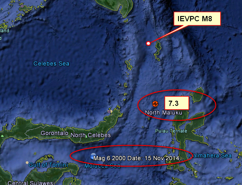
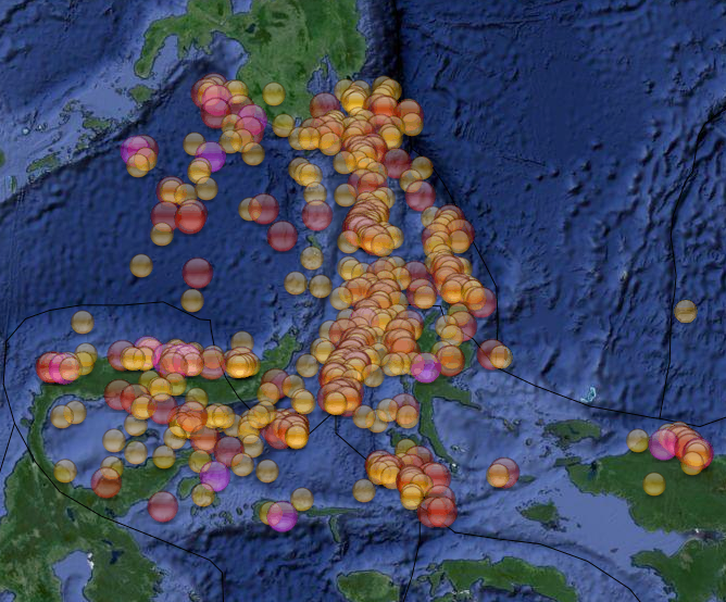
Magnitude 7.3 - Northern Molucca Sea (266)
Location in Google Maps
- Date-Time: Saturday, November 15, 2014 @ 02:31:42 UTC
- Earthquake location: 1.885°N, 126.509°E,
- Earthquake depth: 47.0 km
- Distances:
154km (95mi) NW of Kota Ternate, Indonesia
155km (96mi) ENE of Bitung, Indonesia
155km (96mi) NW of Ternate, Indonesia
167km (103mi) W of Tobelo, Indonesia
1070km (664mi) SW of Koror Town, Palau
- Event ID: usc000sxh8
Derived from Event Data Source: USGS
Powered by QVSData
This is not far off the point given by the IEVPC for the Mag 8 they have predicted.
edit on 14/11/2014 by PuterMan because: (no reason given)
Mag 6+ after shock - more details in a moment
2014-11-15 03:08:05, -0.300, 124.100, 6.2, 85.0 Molucca Sea
EMSC now saying 5.9mb but that translates to about 6.1 Mw
www.emsc-csem.org...
Finally USGS on the scene with 5.9mb as well
earthquake.usgs.gov...
GFZ still on 6.2 but this is automatic
geofon.gfz-potsdam.de...
2014-11-15 03:08:05, -0.300, 124.100, 6.2, 85.0 Molucca Sea
EMSC now saying 5.9mb but that translates to about 6.1 Mw
www.emsc-csem.org...
Finally USGS on the scene with 5.9mb as well
earthquake.usgs.gov...
GFZ still on 6.2 but this is automatic
geofon.gfz-potsdam.de...
edit on 14/11/2014 by PuterMan because: (no reason given)
edit on 14/11/2014 by PuterMan because: To say goodnight to all. See
ya!
I am somewhat in awe of that prediction. Whew, it slid in there right before the closing bell didn't it? Well, it wasn't an 8, but close enough in
the "prediction field" I think we should let them have it.
I am excited to see them actually get one near enough. What does that mean for the future of earthquake watches? I am saddened that Indonesia will more than likely have damage though.
Thank you for bringing that article to my attention PM.
a reply to: PuterMan
I am excited to see them actually get one near enough. What does that mean for the future of earthquake watches? I am saddened that Indonesia will more than likely have damage though.
Thank you for bringing that article to my attention PM.
a reply to: PuterMan
a reply to: PuterMan
Not far in distance but a mile away in strength, unless this is just a precursor.
It is a log scale so it is quite a few magnitudes off.
I don't remember how to do logs way too long ago.
P
This is not far off the point given by the IEVPC for the Mag 8 they have predicted.
Not far in distance but a mile away in strength, unless this is just a precursor.
It is a log scale so it is quite a few magnitudes off.
I don't remember how to do logs way too long ago.
P
I wouldn't give it too much notice, although it is in the general area (278km)
the prediction was from Monday, January 7, 2013 - December 2014
almost 2 years span
its 1,344,028 TTNT(M7.3) versus 15,080,242 TTNT(M8.0)
massive difference
lets not hope its not a foreshock,
the 6.0 aftershock was quite a long way from the 7.3 (362.6km)which might mean this is a major fault about to break
plenty of history there (497 quakes above M5.5 since 1990)
goo.gl... (link good till Feb 2015 ........ apparently)
FYI data comes from Wilber3 ds.iris.edu...
I'm using that instead of Useless these days, same data, but more user friendly presentation , and of course the history aspect right there in the dropdown Load Event Data: space
How long till they dump this handy web page I wonder? or should I say "upgrade " it, and ruin it.
Get all my P and S wave Travel/Arrival Times from here too.
been converted from 7.3 Mwp to 7.1Mww now
the prediction was from Monday, January 7, 2013 - December 2014
almost 2 years span
its 1,344,028 TTNT(M7.3) versus 15,080,242 TTNT(M8.0)
massive difference
lets not hope its not a foreshock,
the 6.0 aftershock was quite a long way from the 7.3 (362.6km)which might mean this is a major fault about to break
plenty of history there (497 quakes above M5.5 since 1990)
goo.gl... (link good till Feb 2015 ........ apparently)
FYI data comes from Wilber3 ds.iris.edu...
I'm using that instead of Useless these days, same data, but more user friendly presentation , and of course the history aspect right there in the dropdown Load Event Data: space
How long till they dump this handy web page I wonder? or should I say "upgrade " it, and ruin it.
Get all my P and S wave Travel/Arrival Times from here too.
edit on 11u31731714 by muzzy because: (no reason given)
been converted from 7.3 Mwp to 7.1Mww now
edit on 11u31731714 by muzzy because: (no reason given)
earthquake.usgs.gov...
M4.5
- 3km E of Whitefish, Montana
2014-11-15 06:58:48 UTC
ShakeMap - VDYFI? - IV
Earthquake location 48.414°N, 114.287°W
Return to the EQ List/Map/Search
kml iconGoogle Earth KML
SummaryLocation and Magnitude contributed by: USGS National Earthquake Information CenterGeneral
+
-
30 km
20 mi
Powered by Leaflet
Montana
48.415°N, 114.287°W
Depth: 8.9km (5.5mi)
Event Time
2014-11-15 06:58:48 UTC
2014-11-14 23:58:48 UTC-07:00 at epicenter
2014-11-14 22:58:48 UTC-08:00 system time
Location
48.414°N 114.287°W depth=8.9km (5.5mi)
Nearby Cities
3km (2mi) E of Whitefish, Montana
24km (15mi) N of Kalispell, Montana
162km (101mi) SE of Cranbrook, Canada
172km (107mi) N of Missoula, Montana
264km (164mi) NW of Helena, Montana
edit on 7/30/2012 by dreamfox1 because: (no reason given)
new topics
-
President BIDEN's FBI Raided Donald Trump's Florida Home for OBAMA-NORTH KOREA Documents.
Political Conspiracies: 2 hours ago -
Maestro Benedetto
Literature: 3 hours ago -
Is AI Better Than the Hollywood Elite?
Movies: 3 hours ago -
Las Vegas UFO Spotting Teen Traumatized by Demon Creature in Backyard
Aliens and UFOs: 7 hours ago -
2024 Pigeon Forge Rod Run - On the Strip (Video made for you)
Automotive Discussion: 8 hours ago -
Gaza Terrorists Attack US Humanitarian Pier During Construction
Middle East Issues: 8 hours ago -
The functionality of boldening and italics is clunky and no post char limit warning?
ATS Freshman's Forum: 9 hours ago -
Meadows, Giuliani Among 11 Indicted in Arizona in Latest 2020 Election Subversion Case
Mainstream News: 10 hours ago -
Massachusetts Drag Queen Leads Young Kids in Free Palestine Chant
Social Issues and Civil Unrest: 10 hours ago -
Weinstein's conviction overturned
Mainstream News: 11 hours ago
top topics
-
President BIDEN's FBI Raided Donald Trump's Florida Home for OBAMA-NORTH KOREA Documents.
Political Conspiracies: 2 hours ago, 16 flags -
Krystalnacht on today's most elite Universities?
Social Issues and Civil Unrest: 13 hours ago, 9 flags -
University of Texas Instantly Shuts Down Anti Israel Protests
Education and Media: 16 hours ago, 8 flags -
Supreme Court Oral Arguments 4.25.2024 - Are PRESIDENTS IMMUNE From Later Being Prosecuted.
Above Politics: 13 hours ago, 8 flags -
Weinstein's conviction overturned
Mainstream News: 11 hours ago, 7 flags -
Massachusetts Drag Queen Leads Young Kids in Free Palestine Chant
Social Issues and Civil Unrest: 10 hours ago, 7 flags -
Gaza Terrorists Attack US Humanitarian Pier During Construction
Middle East Issues: 8 hours ago, 7 flags -
Meadows, Giuliani Among 11 Indicted in Arizona in Latest 2020 Election Subversion Case
Mainstream News: 10 hours ago, 5 flags -
Las Vegas UFO Spotting Teen Traumatized by Demon Creature in Backyard
Aliens and UFOs: 7 hours ago, 4 flags -
2024 Pigeon Forge Rod Run - On the Strip (Video made for you)
Automotive Discussion: 8 hours ago, 3 flags
active topics
-
Massachusetts Drag Queen Leads Young Kids in Free Palestine Chant
Social Issues and Civil Unrest • 14 • : ToneD -
President BIDEN's FBI Raided Donald Trump's Florida Home for OBAMA-NORTH KOREA Documents.
Political Conspiracies • 6 • : pianopraze -
British TV Presenter Refuses To Use Guest's Preferred Pronouns
Education and Media • 169 • : WakeUpBeer -
Is AI Better Than the Hollywood Elite?
Movies • 11 • : rickymouse -
Supreme Court Oral Arguments 4.25.2024 - Are PRESIDENTS IMMUNE From Later Being Prosecuted.
Above Politics • 83 • : Sookiechacha -
Sol Et Luna - TIME2024
Short Stories • 10 • : BrotherKinsMan -
University of Texas Instantly Shuts Down Anti Israel Protests
Education and Media • 263 • : cherokeetroy -
Gaza Terrorists Attack US Humanitarian Pier During Construction
Middle East Issues • 26 • : nugget1 -
Manly P. Hall says Freemasonry is a religion?
Secret Societies • 22 • : Therealbeverage -
One Flame Throwing Robot Dog for Christmas Please!
Weaponry • 11 • : Therealbeverage