It looks like you're using an Ad Blocker.
Please white-list or disable AboveTopSecret.com in your ad-blocking tool.
Thank you.
Some features of ATS will be disabled while you continue to use an ad-blocker.

Quake Watch 2014
page: 97share:
a reply to: PuterMan
I don't think so
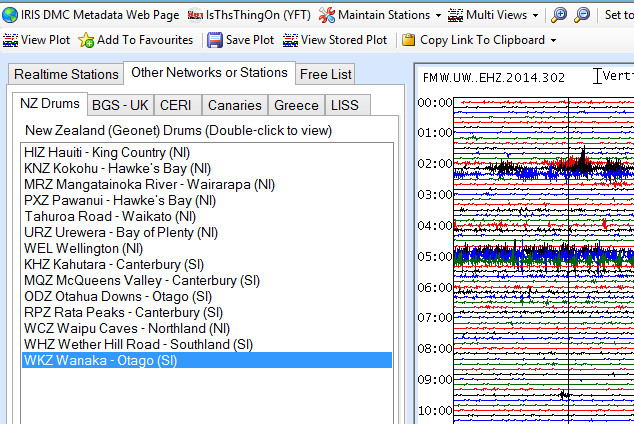
here's one,direct link to image h t t p://images.geonet.org.nz/earthquake/drums/latest/waz-seismic-drum.png
or the page is h t t p://www.geonet.org.nz/quakes/drums/wanganui
The reason I don't know for sure is I don't have the Geonet Drums loaded on DataPro
I don't think so
here's one,direct link to image h t t p://images.geonet.org.nz/earthquake/drums/latest/waz-seismic-drum.png
or the page is h t t p://www.geonet.org.nz/quakes/drums/wanganui
The reason I don't know for sure is I don't have the Geonet Drums loaded on DataPro
a reply to: muzzy
I will take a look at the code and see if there is a problem.
So you are not seeing the data below in the Webicorder viewer?
Yup they have changed the format. I will recode it and issue a new version.
I will take a look at the code and see if there is a problem.
So you are not seeing the data below in the Webicorder viewer?
Yup they have changed the format. I will recode it and issue a new version.
edit on 1/11/2014 by PuterMan because: (no reason given)

LDEO fallen asleep at the wheel?
nothing since
2014/11/2 9: 20: 32.0, -2.75, 147.75, 33.0, 5.0, ADMIRALTY ISLANDS REGION, P.N.G.
www.ldeo.columbia.edu...
I was looking for their take on the Fiji 6.7-7.1 yesterday
nothing since
2014/11/2 9: 20: 32.0, -2.75, 147.75, 33.0, 5.0, ADMIRALTY ISLANDS REGION, P.N.G.
www.ldeo.columbia.edu...
I was looking for their take on the Fiji 6.7-7.1 yesterday
Strange we were talking about Zambia a few days ago and all of a suddenly:...........
Location in Google Maps
Derived from Event Data Source: USGS
Powered by QVSData
Magnitude 5.3 - Zambia (576)
Location in Google Maps
- Date-Time: Sunday, November 02, 2014 @ 18:25:41 UTC
- Earthquake location: 10.971°S, 29.696°E,
- Earthquake depth: 10.0 km
- Distances:
46km (28mi) NNE of Samfya, Zambia
91km (56mi) ENE of Mansa, Zambia
146km (90mi) SSE of Kawambwa, Zambia
182km (113mi) WSW of Kasama, Zambia
513km (318mi) NNE of Lusaka, Zambia
- Event ID: usc000stin
Derived from Event Data Source: USGS
Powered by QVSData
a reply to: PuterMan
Yeah been wondering what’s up with these African quakes the past couple of days… Very unusual. Hopefully they didn't freak the animals out too much. I can imagine a family of gorillas sitting there looking at each other thinking what on earth was that
Yeah been wondering what’s up with these African quakes the past couple of days… Very unusual. Hopefully they didn't freak the animals out too much. I can imagine a family of gorillas sitting there looking at each other thinking what on earth was that
edit on 2-11-2014 by
paradisepurple because: Sp.
a reply to: PuterMan
DO NOT DOWNLOAD THAT VERSION - THERE IS AN ERROR IN THE DATA COLLECTION.
I am working on it.
If you have already installed it revert to 3.1.65.1 which you can download from the page in my signature.
DO NOT DOWNLOAD THAT VERSION - THERE IS AN ERROR IN THE DATA COLLECTION.
I am working on it.
If you have already installed it revert to 3.1.65.1 which you can download from the page in my signature.
edit on 3/11/2014 by PuterMan
because: (no reason given)
a reply to: PuterMan
A new version of QVSData was just released replacing the errored version 3.2.66.1 issued yesterday.
Details of the release and the download links for the standard version can be found here
Pro users will receive an email notification.
The introduction of the SQL Server Compact 4.0 modules caused an error on code that had successfully run with the two previous versions. Indeed the change in version 4.0 seems to be a backward step as it diables a feature that is present in the full SQL Server.
a reply to: muzzy
LDEO still not showing a record of that Fiji M7
I wonder why?
Too deep to show S waves? which is what they use (Ms)
Can't say I have noticed that before, will have to look back, perhaps do a search for deep quakes in the last year or two and then compare with what LDEO archive I have built and see if they showed any that match.
Likely looking at Fiji or Andes in SA.
www.ldeo.columbia.edu...
eqarchives.wordpress.com...
edit on 11u30630614 by muzzy because: (no reason given)
a reply reply to: muzzy (talking to myself again it seems)
If its Ms you want, and I do (for my M7+ project), and besides Ms is more important than anything else IMO, due to the fact that is what we feel as the shaking and it is what does the damage to buildings and infrastructure,
GCMT have that Fiji quake at 7.1Ms link
The Aussies didn't get even get the Ms to M7 or in fact with any magnitude type (finalised) (not towing the USGS line!?)
Mwp: 6.9 (Preferred)
Mb: 6.48
Ms: 6.33
link
GSRAS didn't bother to do the conversion, just posting it as 6.6mb link and also called it West of Tonga, like Geonet did.
Neither did CEDC,
2014-11-02 02:57:20.1 -19.60 -177.80 410 mb6.7 天然地震 斐济群岛地区 link good for about 3 days
So we likely will see USelessGS take it down below M7 on the 7 or 30 day reviewed data, maybe
edit on 11u30730714 by muzzy because: (no reason given)
Interesting to see what people read about NZ earthquakes.
I just noticed I had categorised all my NZ Earthquakes for October under the September category, due to using the copy/template feature on Wordpress and not changing the Month.
484 people read my blog in the last 30 days, but no one noticed!, or didn't bother to give me a heads up in the Comments.
Other 30 day stats are interesting;
Biggest read was 1. SNZO – IRIS (50 views) which has the IRIS graphs for SNZO and which I stopped posting to 11 months ago on Dec 6th 2013 !
2. 13.10.2014 (day286) (13 views) the day of the Puysegur M6.2, which is understandable
3. SNZO Archives (9 views) which has the old LISS graphs for SNZO and I stopped posting to over a year ago on July 20th 2013 !
10. Canterbury Series, NZ 2010 to 2012 (6 views)
maybe its time to bring back LISS, it was always interesting to see wiggles on the graphs that the likes of USGS and EMSC didn't catch
I started saving them again on 13/10, the day of the Puysegur M6.2
I don't suppose anyone else saves these? I asked Puterman, but he hadn't.
LISS
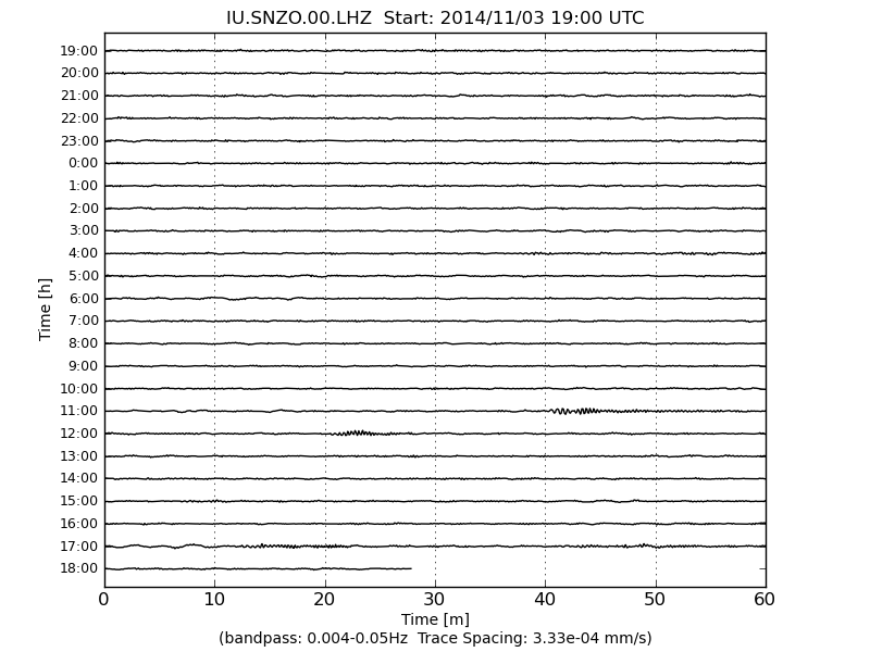
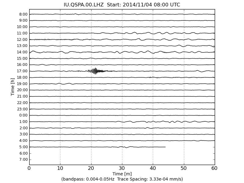
Just noticed on todays graphs something on the 1700 line QSPA and SNZO, Zambia and Kenya, but not RAO or MBWA( W Australia), so likely something went off down south of NZ, or at least close to Antarctica, nothing showing on any Networks
I just noticed I had categorised all my NZ Earthquakes for October under the September category, due to using the copy/template feature on Wordpress and not changing the Month.
484 people read my blog in the last 30 days, but no one noticed!, or didn't bother to give me a heads up in the Comments.
Other 30 day stats are interesting;
Biggest read was 1. SNZO – IRIS (50 views) which has the IRIS graphs for SNZO and which I stopped posting to 11 months ago on Dec 6th 2013 !
2. 13.10.2014 (day286) (13 views) the day of the Puysegur M6.2, which is understandable
3. SNZO Archives (9 views) which has the old LISS graphs for SNZO and I stopped posting to over a year ago on July 20th 2013 !
10. Canterbury Series, NZ 2010 to 2012 (6 views)
maybe its time to bring back LISS, it was always interesting to see wiggles on the graphs that the likes of USGS and EMSC didn't catch
I started saving them again on 13/10, the day of the Puysegur M6.2
I don't suppose anyone else saves these? I asked Puterman, but he hadn't.
LISS
Just noticed on todays graphs something on the 1700 line QSPA and SNZO, Zambia and Kenya, but not RAO or MBWA( W Australia), so likely something went off down south of NZ, or at least close to Antarctica, nothing showing on any Networks
Watching USGS...
Oregon seems to be throwing a small hissy fit !
As usual will be keeping a close eye out!
Oregon seems to be throwing a small hissy fit !
As usual will be keeping a close eye out!
originally posted by: muzzy
...............
Just noticed on todays graphs something on the 1700 line QSPA and SNZO, Zambia and Kenya, but not RAO or MBWA( W Australia), so likely something went off down south of NZ, or at least close to Antarctica, nothing showing on any Networks
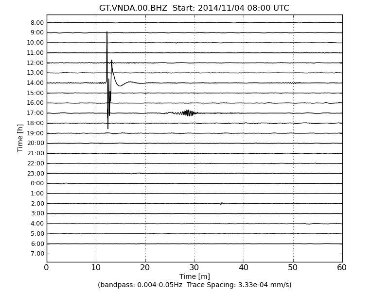
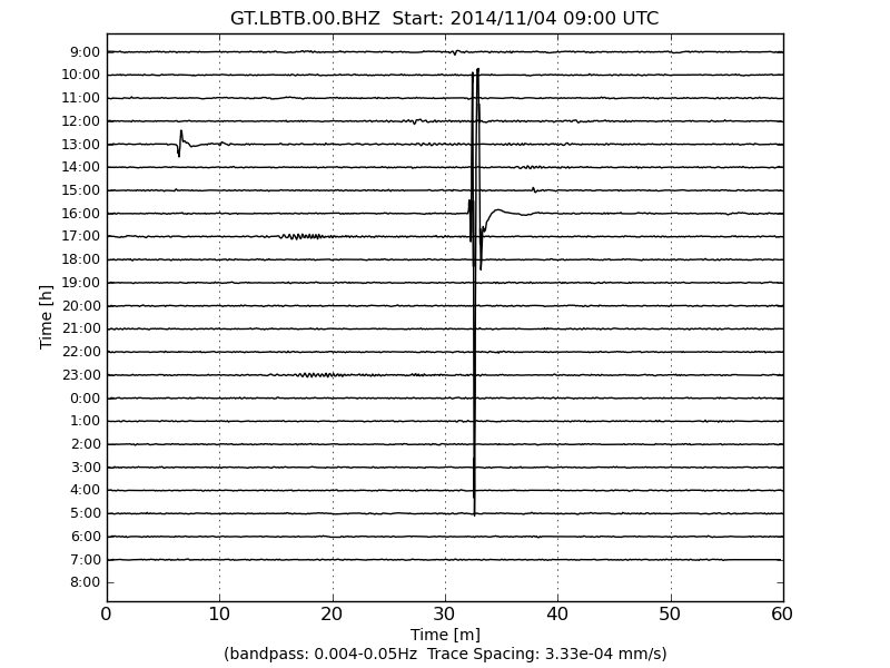
looks like it was this one;
F-E Region: Southern Mid Atlantic Ridge
Time: 2014-11-04 16:58:24.3 UTC
Magnitude: 4.8
Epicenter: 8.98°W 49.05°S
Depth: 10 km
Confirmed by Wilber3, part of IRIS ds.iris.edu...
49.0343° S 9.064° W 2014-11-04 16:58:24 UTC 15.0 km MB4.9 Southern Mid-Atlantic Ridge
Yes, it was showing on the following stations, with relevant arrival times.
SNZO: South Karori, New Zealand,
P +12m 56s, 17:11:20, S +23m 47s, 17:22:11
QSPA: South Pole Remote Earth Science Observatory (Quiet Zone)
P +7m 42s, 17:06:06, S +13m 55s, 17:12:19
VNDA: Wright Valley (Bull Pass) Antarctica, in the Mts behind McMurdo Sound
P +9m 18s, 17:07:42, S +16m 50s, 17:15:14
LBTB: Lobatse, Botswana, Africa
P +7m 1s, 17:05:25, S +12m 40s, 17:11:04
Amazing it showed on SNZO, for a M4.9, its so far away, 9962 km
The graphs for that period are gone now, thats why its called Live ISS
and why someone should save them.
I'll get onto it, am depending on WIlber3 for the arrival time details, if they don't post the event then there is no AT detail.
I'll make some new pages on GSAIM which has been sitting idle for 3 months and new SNZO and RAO pages on NZEQ
On VNDA and LBTB there were a couple of local quakes as well, different times, no sign of where/howbigtheywere on any networks.
edit on 1100000030830814 by muzzy because: (no reason given)
seen it on the graphs, strong showing on SNZO and RAO
That Coleville Ridge seems to transfer the S waves straight down the length to Cook Strait
16.694° S 179.0337° W 2014-11-05 18:13:18 UTC 10.0 km MB4.9 Fiji Islands Region
ds.iris.edu...
edit on 11u30830814 by muzzy because: add event and link
LISS
edit on 11u30830814 by muzzy because: another link
Interesting swarm going on in Oregon.
Dang, sorry trying to post pict but having problems
Text
Dang, sorry trying to post pict but having problems
Strong Earthquake Gulf Of California
08-Oct-14 (E142810240) - Downgraded from 6.2 to 6.0
Actually one of the first downgrades/upgrades for some time. They used to be very frequent but now they are either more accurate or less bothered! (Or do it after 30 days which misses my radar)
Actually one of the first downgrades/upgrades for some time. They used to be very frequent but now they are either more accurate or less bothered! (Or do it after 30 days which misses my radar)
a reply to: crappiekat
Yes it is... been observing the swarm for a few days now.
I don't think we have seen the worst of it yet.
Yes it is... been observing the swarm for a few days now.
I don't think we have seen the worst of it yet.
a reply to: crappiekat
a reply to: MamaJ
Neither of you have given links
If this is the swarm, then crappiekat needs to go back to skool for geography lessons
its in Nevada
The Sheldon National Antelope Refuge, Nevada
222 quakes since 23/10/2014
7 x M4's in it
pnsn.org...
Looking at USelessGS I see that you were sucked in by the terrible location system they use, given as ... ESE/SE of Lakeview, Oregon
even though they were in Nevada.
This is why the location system is useless and confusing
a reply to: MamaJ
Neither of you have given links
If this is the swarm, then crappiekat needs to go back to skool for geography lessons
its in Nevada
The Sheldon National Antelope Refuge, Nevada
222 quakes since 23/10/2014
7 x M4's in it
pnsn.org...
edit on 1100000030930914 by muzzy because: (no reason given)
Looking at USelessGS I see that you were sucked in by the terrible location system they use, given as ... ESE/SE of Lakeview, Oregon
even though they were in Nevada.
This is why the location system is useless and confusing
edit on 1100000030930914 by muzzy because: (no reason given)
new topics
-
Bobiverse
Fantasy & Science Fiction: 2 hours ago -
Florida man's trip overseas ends in shock over $143,000 T-Mobile phone bill
Social Issues and Civil Unrest: 2 hours ago -
Former Labour minister Frank Field dies aged 81
People: 4 hours ago -
SETI chief says US has no evidence for alien technology. 'And we never have'
Aliens and UFOs: 6 hours ago -
This is our Story
General Entertainment: 8 hours ago -
President BIDEN Vows to Make Americans Pay More Federal Taxes in 2025 - Political Suicide.
2024 Elections: 11 hours ago -
Ode to Artemis
General Chit Chat: 11 hours ago
top topics
-
President BIDEN Vows to Make Americans Pay More Federal Taxes in 2025 - Political Suicide.
2024 Elections: 11 hours ago, 14 flags -
Should Biden Replace Harris With AOC On the 2024 Democrat Ticket?
2024 Elections: 17 hours ago, 6 flags -
One Flame Throwing Robot Dog for Christmas Please!
Weaponry: 15 hours ago, 6 flags -
Florida man's trip overseas ends in shock over $143,000 T-Mobile phone bill
Social Issues and Civil Unrest: 2 hours ago, 5 flags -
Don't take advantage of people just because it seems easy it will backfire
Rant: 15 hours ago, 4 flags -
Ditching physical money
History: 15 hours ago, 4 flags -
SETI chief says US has no evidence for alien technology. 'And we never have'
Aliens and UFOs: 6 hours ago, 4 flags -
Former Labour minister Frank Field dies aged 81
People: 4 hours ago, 4 flags -
Ode to Artemis
General Chit Chat: 11 hours ago, 3 flags -
This is our Story
General Entertainment: 8 hours ago, 3 flags
active topics
-
VirginOfGrand says hello
Introductions • 3 • : F2d5thCavv2 -
President BIDEN Vows to Make Americans Pay More Federal Taxes in 2025 - Political Suicide.
2024 Elections • 53 • : Bluntone22 -
"We're All Hamas" Heard at Columbia University Protests
Social Issues and Civil Unrest • 272 • : WeMustCare -
The Acronym Game .. Pt.3
General Chit Chat • 7743 • : F2d5thCavv2 -
SETI chief says US has no evidence for alien technology. 'And we never have'
Aliens and UFOs • 25 • : Cvastar -
Suspended Nigerian Poverty Minister had $24M in her Bank Accounts
Political Issues • 11 • : malamarabi -
Should Biden Replace Harris With AOC On the 2024 Democrat Ticket?
2024 Elections • 47 • : Cvastar -
Florida man's trip overseas ends in shock over $143,000 T-Mobile phone bill
Social Issues and Civil Unrest • 2 • : mysterioustranger -
Post A Funny (T&C Friendly) Pic Part IV: The LOL awakens!
General Chit Chat • 7133 • : underpass61 -
Thousands Of Young Ukrainian Men Trying To Flee The Country To Avoid Conscription And The War
Other Current Events • 128 • : twistedpuppy