It looks like you're using an Ad Blocker.
Please white-list or disable AboveTopSecret.com in your ad-blocking tool.
Thank you.
Some features of ATS will be disabled while you continue to use an ad-blocker.

Volcano Watch 2014
page: 21share:
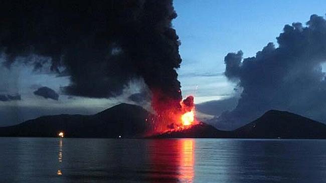
PNG volcano Tavurvur eruption may disrupt Australian flights
A MAJOR volcanic eruption in Papua New Guinea this morning could disrupt flights to and from Australia.
The Volcanic Ash Advisory Centre in Darwin is monitoring the ash cloud from Tavurcur on PNG’s East Britain Island, which is slowly drifting southwest.
Senior meteorologist Ian Shepherd said they were watching the cloud closely and providing advice to airlines.
“The volcanic eruption reached the top of the atmosphere at 50,000 feet which is the same height as which planes travel,” said Mr Shepherd.
The news site PNGloop reported that ash from the volcano is blowing toward the north coast of the island. The site also posted a notice from the Department of Mineral Policy and Geohazards Management that stated the eruption commenced between 3.30am-4am. The eruption involved “incandescent projections and ongoing loud roaring and rumbling noises,” the notice stated.
Link
edit on 29-8-2014 by lurksoften because: (no reason given)
edit on 29-8-2014 by lurksoften because: (no reason given)
HI Muzzy, yes you found it.
(I was in bed or I would have said so sooner.)
www.ruv.is...
I don't think this is over either.
M.
(I was in bed or I would have said so sooner.)
"It was a small eruption and a small sample of the magma that is moving underground reached the surface," says Páll, describing the events of the night as an abberation in the larger course of events of the last two weeks.
Páll agrees with fellow professor of geophysics, Magnús Tumi Guðmundsson, who earlier today described the eruption as an "accident". "The magma intrusion strayed unnecessarily close to the surface and some magma came out," Páll says.
www.ruv.is...
I don't think this is over either.
M.
a reply to: Thebel
Based on that this is where it is at (approx.) 64.896534, -16.810223. Coloured Icons are earthquakes for the 29th, last event archived 14:00 UTC
[pic]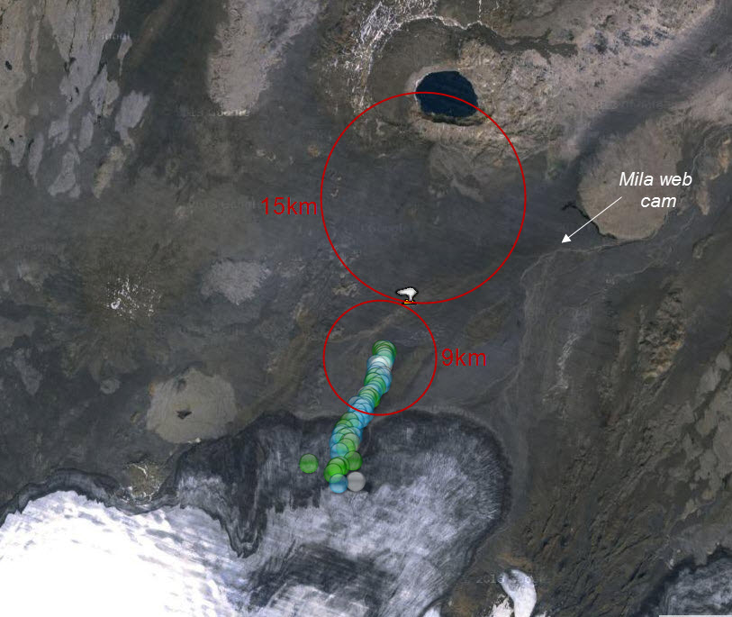 [/pic]
cameras are on!
Bunga 2 seems to be showing better at this time (17:33 UTC), some steam?
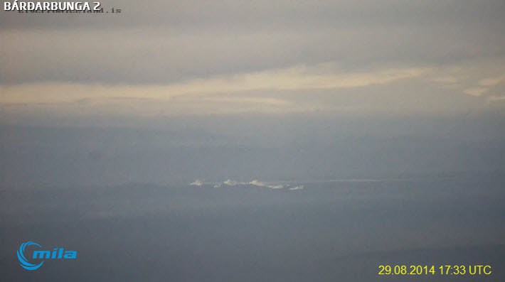
compare with earlier (4:09 UTC)
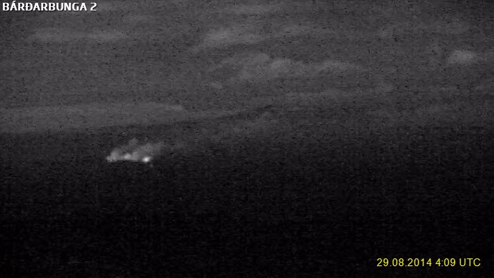
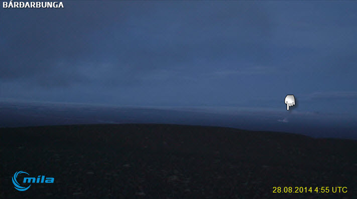
Bunga 1 not showing much (17:39 UTC)
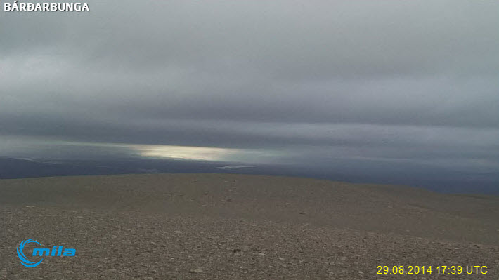
compared with earlier, (4:55UTC)
A fissure eruption started around midnight in the Holuhraun lavafield, ca. 9 kilometers north of Dyngjujokull glacier. Lava streams out of a 100 meter long fissure, in the northern part of the lava field, about 15 kilometers south of the Askja caldera.
Based on that this is where it is at (approx.) 64.896534, -16.810223. Coloured Icons are earthquakes for the 29th, last event archived 14:00 UTC
[pic]
cameras are on!
Bunga 2 seems to be showing better at this time (17:33 UTC), some steam?
compare with earlier (4:09 UTC)
Bunga 1 not showing much (17:39 UTC)
compared with earlier, (4:55UTC)
edit on 0800000024024014 by muzzy because: (no reason given)
From Bardarbunga Updates
Possible scenarios
"- At 00:02 UTC signs of a lava eruption were detected on web camera images from Mila. The web-camera is located at Vaðalda, north-east of the eruption site.
- Around midnight, weak signs of increased tremor were apparent on IMO's seismic stations near to the eruption site. At 00:20 UTC scientists in the field from the Icelandic Met Office, Institute of Earth Sciences and Cambridge University confirmed the location of the eruption.
- The eruption occurred on an old volcanic fissure on the Holuhraun lava field, about 5 km north of the Dyngjujökull ice margin. The active fissure was about 600 m in length.
A small amount of lava drained from the fissure and by around 04:00 UTC, lava flow is thought to have stopped.
- According to seismic data and web-camera imagery, the eruption peaked between 00:40 and 01:00 UTC.
- At the beginning of the eruption, seismic activity decreased, although seismicity has since returned to levels observed in recent days.
- Aerial observations by the Icelandic Coastguard show that only steam is rising from the site of the lava eruption.
- There are no indications that the intensity of the activity declining.
Possible scenarios
1 The migration of magma could stop, resulting in a gradual reduction in seismic activity and no further eruptions.
2 The dike could reach the Earth's surface north of Dyngjujökull causing another eruption, possibly on a new fissure. Such an eruption could include lava flow and (or) explosive activity.
3 The intrusion reaches the surface and an eruption occurs again where either the fissure is partly or entirely beneath Dyngjujökull. This would most likely produce a flood in Jökulsá á Fjöllum and perhaps explosive, ash-producing activity.
Other scenarios cannot be excluded. For example, an eruption inside the Bárdarbunga caldera."
a reply to: whatnext21
Dr. Tom Pfeiffer does a damn good job on Volcano Discovery, but the images are lousy
Its pretty disappointing the coverage IMO are giving this, where are the high quality Coast Guard images?
Geez its been 18 hours since the eruption, wheres the pics?
Dr. Tom Pfeiffer does a damn good job on Volcano Discovery, but the images are lousy
Its pretty disappointing the coverage IMO are giving this, where are the high quality Coast Guard images?
Geez its been 18 hours since the eruption, wheres the pics?
edit on 0800000024024014 by muzzy because: (no reason given)
Not sure when this came out, its pretty awesome, a lot of work must have gone into this
en.vedur.is...
3D direct link
coloured patches on the surface only work on the satellite version on Chrome
good effort though
I like the 10X on Chrome
An interactive 3D model of the earthquakes in Bárðarbunga – preliminary version
Instructions
The depth of the earthquakes is indicated by two planes, at 5 km and 10 km. The topography is exaggerated by factor 5. The depth of the earthquakes is not exaggerated, they are positioned with sea level as a referral plane.
Coloured patches on the surface represent the 20 most recent earthquakes. As the coloured patches move on they leave a gray color, which consequently shows where the activity has been. Doing is learning and our users are encouraged to test out the interactive possibilities:
zoom in and out (central mouse scroll), pan (right click), turn over (left click)
choose speed 1x, 2x, 10x (available in some browsers (e.g. Chrome but not Firefox)
coloured patches on/off (ring icon)
choose landscape map (mountain icon) or satellite image (bell icon) for the surface
Tryggvi Hjörvar, specialist at the Icelandic Met Office, created this mode
en.vedur.is...
3D direct link
coloured patches on the surface only work on the satellite version on Chrome
good effort though
I like the 10X on Chrome
edit on 0800000024024014 by muzzy because: (no reason given)
a reply to: lurksoften
Thank you for the info on Tavurvur.
Check out the massive amount of Sulfur Dioxide it released. I wouldn't want to be breathing that.
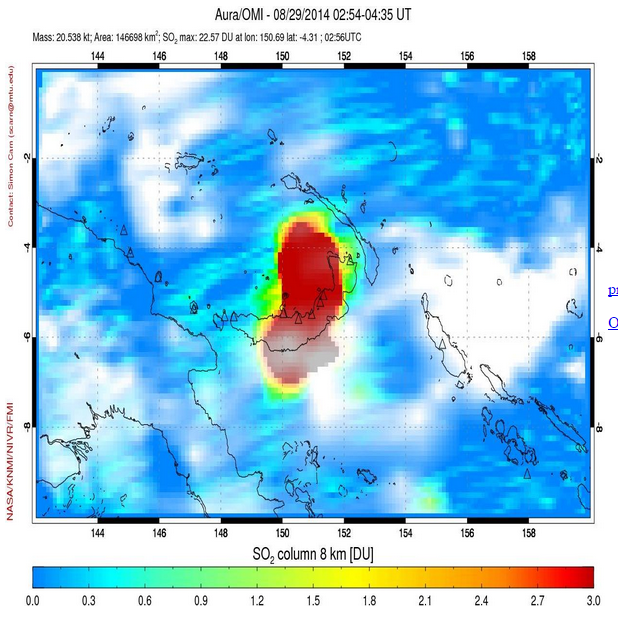
source
a reply to: muzzy
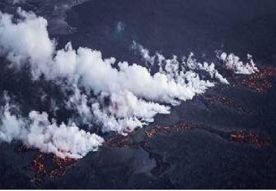
There are some cool photos floating around. Here is one from @fencingtobba on twitter.
That map is awesome, and stays updated to within a few hours. Agreed, 10X speed is the way to go. When I used it for the 1st time yesterday, it took almost 10 minutes to watch the animation at normal speed.
Thank you for the info on Tavurvur.
Check out the massive amount of Sulfur Dioxide it released. I wouldn't want to be breathing that.
source
a reply to: muzzy
There are some cool photos floating around. Here is one from @fencingtobba on twitter.
That map is awesome, and stays updated to within a few hours. Agreed, 10X speed is the way to go. When I used it for the 1st time yesterday, it took almost 10 minutes to watch the animation at normal speed.
edit on 8/29/2014 by Olivine because: (no reason given)
edit on
8/29/2014 by Olivine because: poor spacing
a reply to: BGTM90
Really? Maybe it doesn't seem like much because this is just a snapshot for a few hours. It sure looks like a huge emission.
Here is the daily shot of China today
It has a listing for Mass: 0.270kt.
Really? Maybe it doesn't seem like much because this is just a snapshot for a few hours. It sure looks like a huge emission.
Here is the daily shot of China today
It has a listing for Mass: 0.270kt.
a reply to: Olivine
I used the figure of 25,000,000 tons per year divided it by 365 to get a daily emission. That figures from 2008 though they could have reduced their emmissios but I'm pretty sure it's been going up. Maybe it is a seasonal thing.
I used the figure of 25,000,000 tons per year divided it by 365 to get a daily emission. That figures from 2008 though they could have reduced their emmissios but I'm pretty sure it's been going up. Maybe it is a seasonal thing.
edit on 29-8-2014 by BGTM90 because: (no reason given)
Magnitude 5.4 quake in Bárðarbunga caldera, and before that there was 4.5 and 4.2. The caldera still seems to be collapsing.
Saturday 30.08.2014 07:03:02 64.611 -17.457 2.9 km 5.4 99.0 4.7 km SE of Bárðarbunga
Saturday 30.08.2014 06:18:43 64.678 -17.465 9.1 km 4.2 99.0 5.1 km NE of Bárðarbunga
Saturday 30.08.2014 02:35:34 64.676 -17.463 8.3 km 4.5 99.0 5.0 km NE of Bárðarbunga
There is very bad weather coming for the area, which could make webcam useless. Also would cause wrong readings to tremor graphs. Its hard to see if the fissure is still erupting, there seems to be dust storms(?). The webcam plays very smooth now, showing low clouds passing by fast.
edit on
30-8-2014 by Thebel because: (no reason given)
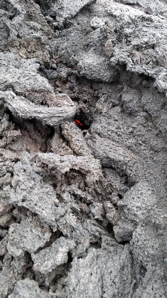
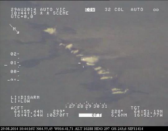
I think I've got the exact location of the fissure eruption, from watching the steam eruptions on TV News tonight I noticed a big gash in the
landscape which I recognized from looking at the Google satellite maps for nearly a week plotting earthquake locations.
had a bit of a fiddle around with the co-ordinates on the Coast Guard image, converting the hrs:min.sec
lat 64:51.19N, Long 16:52.59W to decimal equals 64.855527, -16.88305
pop that on Google Earth and voiila!! there's the gash, just to the SW at 640metres away , just like on the TV video
they were saying it was about half a kilometer or longer steam eruption.
quite dramatic footage from the air.
Anybody kbnow what happened to the youtube live bardabunga channel? I can't find it. I've got the live from iceland up
I think the Youtube live Bardarbunga channel died due to gross stupidity.
Well, that and the fact that the Live from Icelands feeds are so unstable due to overloading.
You can still get the Bardarbunga live feeds if you hit refresh (F5) until it connects.
www.livefromiceland.is...
www.livefromiceland.is...
I prefer Bardarbunga 2 due to the large moving panorama, very soothing.
This is the IRC Channel they used during the live stream
kiwiirc.com...
M.
Activity in Bárðarbunga has dropped significantly. Dike is no longer going towards Askja, maybe hit the hard granite layers around the volcano.
There is still activity within the dike, but Bárðarbunga caldera is calm. Askja has calmed down too. But I expect this to be long-time event. Its
the fact that Iceland is long due for significant volcanic activity, it has never been so calm as its now.
Eruptions of VEI-5 or more:
Askja 1875
Bárðarbunga 1477
Eldgjá 934 (part of Katla)
Hekla 1104
Katla 1755, 1918
Laki 1783 (part of Grimsvötn)
Öraefajökull 1362
Eruptions of VEI-5 or more:
Askja 1875
Bárðarbunga 1477
Eldgjá 934 (part of Katla)
Hekla 1104
Katla 1755, 1918
Laki 1783 (part of Grimsvötn)
Öraefajökull 1362
edit on 30-8-2014 by Thebel because: (no reason given)
new topics
-
A Warning to America: 25 Ways the US is Being Destroyed
New World Order: 17 minutes ago -
America's Greatest Ally
General Chit Chat: 1 hours ago -
President BIDEN's FBI Raided Donald Trump's Florida Home for OBAMA-NORTH KOREA Documents.
Political Conspiracies: 6 hours ago -
Maestro Benedetto
Literature: 7 hours ago -
Is AI Better Than the Hollywood Elite?
Movies: 7 hours ago -
Las Vegas UFO Spotting Teen Traumatized by Demon Creature in Backyard
Aliens and UFOs: 11 hours ago
top topics
-
President BIDEN's FBI Raided Donald Trump's Florida Home for OBAMA-NORTH KOREA Documents.
Political Conspiracies: 6 hours ago, 26 flags -
Krystalnacht on today's most elite Universities?
Social Issues and Civil Unrest: 17 hours ago, 9 flags -
Gaza Terrorists Attack US Humanitarian Pier During Construction
Middle East Issues: 12 hours ago, 8 flags -
Supreme Court Oral Arguments 4.25.2024 - Are PRESIDENTS IMMUNE From Later Being Prosecuted.
Above Politics: 17 hours ago, 8 flags -
Weinstein's conviction overturned
Mainstream News: 15 hours ago, 8 flags -
Massachusetts Drag Queen Leads Young Kids in Free Palestine Chant
Social Issues and Civil Unrest: 14 hours ago, 7 flags -
Las Vegas UFO Spotting Teen Traumatized by Demon Creature in Backyard
Aliens and UFOs: 11 hours ago, 6 flags -
Meadows, Giuliani Among 11 Indicted in Arizona in Latest 2020 Election Subversion Case
Mainstream News: 14 hours ago, 5 flags -
2024 Pigeon Forge Rod Run - On the Strip (Video made for you)
Automotive Discussion: 12 hours ago, 4 flags -
Is AI Better Than the Hollywood Elite?
Movies: 7 hours ago, 3 flags
active topics
-
Massachusetts Drag Queen Leads Young Kids in Free Palestine Chant
Social Issues and Civil Unrest • 15 • : tarantulabite1 -
A Warning to America: 25 Ways the US is Being Destroyed
New World Order • 0 • : charlest2 -
America's Greatest Ally
General Chit Chat • 1 • : BingoMcGoof -
How ageing is" immune deficiency"
Medical Issues & Conspiracies • 35 • : annonentity -
HORRIBLE !! Russian Soldier Drinking Own Urine To Survive In Battle
World War Three • 49 • : Freeborn -
Gaza Terrorists Attack US Humanitarian Pier During Construction
Middle East Issues • 30 • : Asher47 -
Electrical tricks for saving money
Education and Media • 8 • : anned1 -
Is AI Better Than the Hollywood Elite?
Movies • 16 • : 5thHead -
Hate makes for strange bedfellows
US Political Madness • 48 • : Terpene -
President BIDEN's FBI Raided Donald Trump's Florida Home for OBAMA-NORTH KOREA Documents.
Political Conspiracies • 17 • : BingoMcGoof