It looks like you're using an Ad Blocker.
Please white-list or disable AboveTopSecret.com in your ad-blocking tool.
Thank you.
Some features of ATS will be disabled while you continue to use an ad-blocker.

Rough evening shaping up for Oklahoma, Moore and points NE - Tornado Emergency Declared
page: 6share:
Source: ABC Channel 7 OKC
EL RENO, Okla. -- The Oklahoma Highway Patrol says motorists have been hurt in a storm that hit the Oklahoma City area and that others are missing. The National Weather Service issued a tornado emergency for the city's downtown, airport and several suburbs as the storm rolled through central Oklahoma.
Trooper Betsy Randolph said numerous vehicles were damaged in the storm and that many motorists are stranded. The Highway Patrol is urging motorists to get off Interstate 40 and drive to the south. A tornado touched down near El Reno and the storm moved to the east, toward Oklahoma City.
Sounds like a bad hit there on the West side of OKC from El Reno onward. I hope it's minimal for harm.
Originally posted by pez1975
possible tornado will go directly over my house at 8:11
Please stay safe and hope you are under ground!!
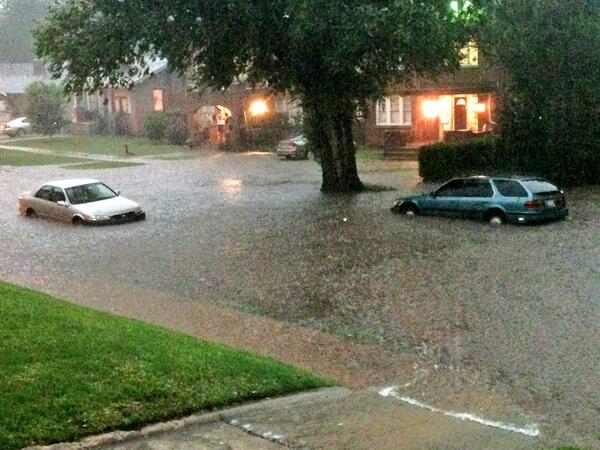
Damage reported in Moore in the same exact areas where the last tornado hit on the 20th (per Channel 9).
edit on 31-5-2013 by _BoneZ_ because: (no reason given)
thank god it has weakened i live se of manford ok they had me #ten my britches
The National Weather Service in St Louis has issued a
* Tornado Warning for...
northwestern Monroe County in southwest Illinois...
East Central Franklin County in east central Missouri...
northern Jefferson County in east central Missouri...
southern St. Louis County in east central Missouri...
www.wunderground.com...
* Tornado Warning for...
northwestern Monroe County in southwest Illinois...
East Central Franklin County in east central Missouri...
northern Jefferson County in east central Missouri...
southern St. Louis County in east central Missouri...
www.wunderground.com...
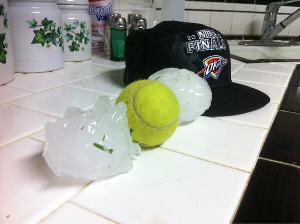
man that was scary were geting large hail its broken my sky light
8:06pm CDT: Large dangerous tornado near I-70 bridge over the Missouri River at St Charles, MO!! Take cover in NW suburbs of St Louis!
twitter.com...
we are safe now the storm has passed over with only minor damage thank you for your prayers everyone and continue to pray for all us okies
Originally posted by antar
Just out on the porch, like a constant sound of rolling thunder with spider web looking lightning. Will log off now and start unplugging the important stuff. Should be ok, but want to be safe and sure. If Ok. is tornado alley, we here in mo. are the bowling pins.
Will check back later.
All of my friends in OK and MO know that my prayers and positive thoughts are with you.
We love you Antar! Stay safe dear friend. Please check back when you are in the clear.
~OKieDokie
A Tornado Warning remains in effect for northern St. Louis city...
northeastern St. Louis... northeastern St. Charles and western Madison
counties until 845 PM CDT...
At 810 PM CDT... a confirmed large and extremely dangerous tornado was
located near Bridgeton... and moving east at 50 mph.
Locations impacted include...
overland... Lambert Field... Woodson Terrace... St. John... University
City... Hazelwood... Berkeley... Bel-Ridge... Kinloch... Florissant... Cool
Valley... Normandy... Hillsdale... Ferguson... Northwoods... Dellwood...
Jennings... Black Jack... Bellefontaine Neighbors and Riverview.
www.wunderground.com...
Wundermap
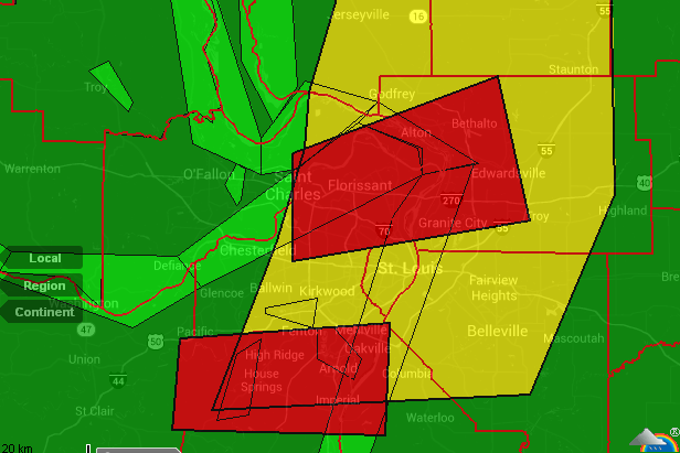
Tornado Watch 260 remains in effect until 1000 PM CDT for the
following locations
MO
. Missouri counties included are
Barry Barton Benton
Boone Callaway Camden
Cedar Christian Cole
Dade Dallas Greene
Hickory Jasper Laclede
Lawrence McDonald Maries
Miller Moniteau Morgan
Newton Osage Phelps
Polk Pulaski St. Clair
stone Taney Vernon
Webster
www.wunderground.com...
edit on 31-5-2013 by MariaLida because: (no reason given)
8:18pm CDT - Tornado in St Louis metro following path similar to (though maybe not exactly same as) EF4 on April 22, 2011
twitter.com...
new topics
-
Putin, Russia and the Great Architects of the Universe
ATS Skunk Works: 1 hours ago -
A Warning to America: 25 Ways the US is Being Destroyed
New World Order: 6 hours ago -
President BIDEN's FBI Raided Donald Trump's Florida Home for OBAMA-NORTH KOREA Documents.
Political Conspiracies: 11 hours ago
top topics
-
President BIDEN's FBI Raided Donald Trump's Florida Home for OBAMA-NORTH KOREA Documents.
Political Conspiracies: 11 hours ago, 29 flags -
A Warning to America: 25 Ways the US is Being Destroyed
New World Order: 6 hours ago, 12 flags -
Las Vegas UFO Spotting Teen Traumatized by Demon Creature in Backyard
Aliens and UFOs: 16 hours ago, 7 flags -
2024 Pigeon Forge Rod Run - On the Strip (Video made for you)
Automotive Discussion: 17 hours ago, 4 flags -
Is AI Better Than the Hollywood Elite?
Movies: 13 hours ago, 3 flags -
Maestro Benedetto
Literature: 13 hours ago, 1 flags -
Putin, Russia and the Great Architects of the Universe
ATS Skunk Works: 1 hours ago, 1 flags
active topics
-
Weinstein's conviction overturned
Mainstream News • 27 • : brodby -
University of Texas Instantly Shuts Down Anti Israel Protests
Education and Media • 270 • : Xtrozero -
Gaza Terrorists Attack US Humanitarian Pier During Construction
Middle East Issues • 38 • : brodby -
ChatGPT Beatles songs about covid and masks
Science & Technology • 24 • : iaylyan -
The Acronym Game .. Pt.3
General Chit Chat • 7754 • : bally001 -
Nearly 70% Of Americans Want Talks To End War In Ukraine
Political Issues • 96 • : andy06shake -
Rupert Murdoch engaged at 92
People • 8 • : brodby -
"We're All Hamas" Heard at Columbia University Protests
Social Issues and Civil Unrest • 287 • : FlyersFan -
Skinwalker Ranch and the Mystery 1.6GHz Signal
Aliens and UFOs • 144 • : brodby -
A Warning to America: 25 Ways the US is Being Destroyed
New World Order • 11 • : brodby